Manual de Teledetección - Secretaría de Ambiente y Desarrollo ...
Manual de Teledetección - Secretaría de Ambiente y Desarrollo ...
Manual de Teledetección - Secretaría de Ambiente y Desarrollo ...

You also want an ePaper? Increase the reach of your titles
YUMPU automatically turns print PDFs into web optimized ePapers that Google loves.
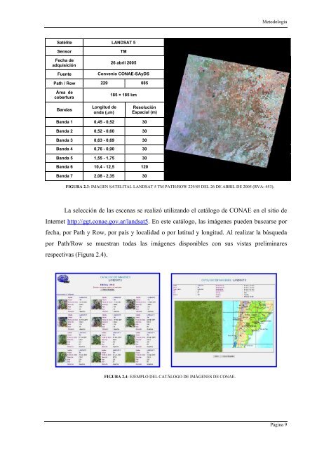
Satélite LANDSAT 5<br />
Sensor TM<br />
Fecha <strong>de</strong><br />
adquisición<br />
26 abril 2005<br />
Fuente Convenio CONAE-SAyDS<br />
Path / Row 229 085<br />
Área <strong>de</strong><br />
cobertura<br />
Bandas<br />
Longitud <strong>de</strong><br />
onda (µm)<br />
185 × 185 km<br />
Resolución<br />
Espacial (m)<br />
Banda 1 0,45 - 0,52 30<br />
Banda 2 0,52 - 0,60 30<br />
Banda 3 0,63 - 0,69 30<br />
Banda 4 0,76 - 0,90 30<br />
Banda 5 1,55 - 1,75 30<br />
Banda 6 10,4 - 12,5 120<br />
Banda 7 2,08 - 2,35 30<br />
FIGURA 2.3: IMAGEN SATELITAL LANDSAT 5 TM PATH/ROW 229/85 DEL 26 DE ABRIL DE 2005 (RVA: 453).<br />
Metodología<br />
La selección <strong>de</strong> las escenas se realizó utilizando el catálogo <strong>de</strong> CONAE en el sitio <strong>de</strong><br />
Internet http://ggt.conae.gov.ar/landsat5. En este catálogo, las imágenes pue<strong>de</strong>n buscarse por<br />
fecha, por Path y Row, por país y localidad o por latitud y longitud. Al realizar la búsqueda<br />
por Path/Row se muestran todas las imágenes disponibles con sus vistas preliminares<br />
respectivas (Figura 2.4).<br />
FIGURA 2.4: EJEMPLO DEL CATÁLOGO DE IMÁGENES DE CONAE.<br />
Página 9