Ver Documento... - Conagua
Ver Documento... - Conagua
Ver Documento... - Conagua

You also want an ePaper? Increase the reach of your titles
YUMPU automatically turns print PDFs into web optimized ePapers that Google loves.
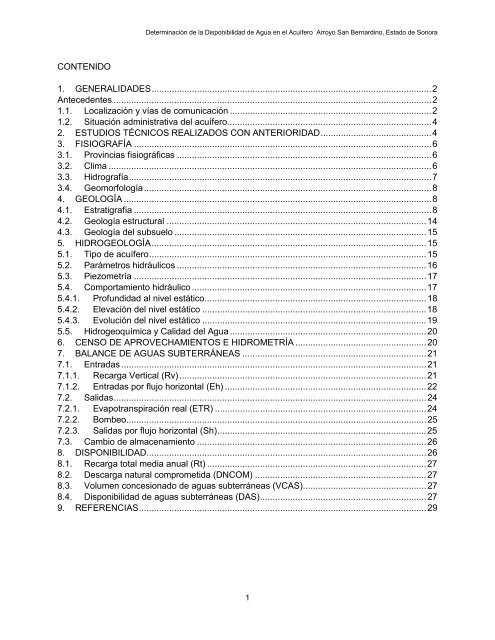
CONTENIDO<br />
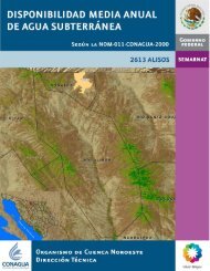
Determinación de la Disponibilidad de Agua en el Acuífero Arroyo San Bernardino, Estado de Sonora<br />
1. GENERALIDADES ............................................................................................................... 2<br />
Antecedentes .............................................................................................................................. 2<br />
1.1. Localización y vías de comunicación ................................................................................ 2<br />
1.2. Situación administrativa del acuífero ................................................................................. 4<br />
2. ESTUDIOS TÉCNICOS REALIZADOS CON ANTERIORIDAD ............................................ 4<br />
3. FISIOGRAFÍA ...................................................................................................................... 6<br />
3.1. Provincias fisiográficas ..................................................................................................... 6<br />
3.2. Clima ................................................................................................................................ 6<br />
3.3. Hidrografía ........................................................................................................................ 7<br />
3.4. Geomorfología .................................................................................................................. 8<br />
4. GEOLOGÍA .......................................................................................................................... 8<br />
4.1. Estratigrafía ...................................................................................................................... 8<br />
4.2. Geología estructural ....................................................................................................... 14<br />
4.3. Geología del subsuelo .................................................................................................... 15<br />
5. HIDROGEOLOGÍA ............................................................................................................. 15<br />
5.1. Tipo de acuífero .............................................................................................................. 15<br />
5.2. Parámetros hidráulicos ................................................................................................... 16<br />
5.3. Piezometría .................................................................................................................... 17<br />
5.4. Comportamiento hidráulico ............................................................................................. 17<br />
5.4.1. Profundidad al nivel estático ........................................................................................ 18<br />
5.4.2. Elevación del nivel estático ......................................................................................... 18<br />
5.4.3. Evolución del nivel estático ......................................................................................... 19<br />
5.5. Hidrogeoquímica y Calidad del Agua .............................................................................. 20<br />
6. CENSO DE APROVECHAMIENTOS E HIDROMETRÍA .................................................... 20<br />
7. BALANCE DE AGUAS SUBTERRÁNEAS ......................................................................... 21<br />
7.1. Entradas ......................................................................................................................... 21<br />
7.1.1. Recarga <strong>Ver</strong>tical (Rv) .................................................................................................. 21<br />
7.1.2. Entradas por flujo horizontal (Eh) ................................................................................ 22<br />
7.2. Salidas ............................................................................................................................ 24<br />
7.2.1. Evapotranspiración real (ETR) .................................................................................... 24<br />
7.2.2. Bombeo ....................................................................................................................... 25<br />
7.2.3. Salidas por flujo horizontal (Sh) ................................................................................... 25<br />
7.3. Cambio de almacenamiento ........................................................................................... 26<br />
8. DISPONIBILIDAD............................................................................................................... 26<br />
8.1. Recarga total media anual (Rt) ....................................................................................... 27<br />
8.2. Descarga natural comprometida (DNCOM) .................................................................... 27<br />
8.3. Volumen concesionado de aguas subterráneas (VCAS) ................................................. 27<br />
8.4. Disponibilidad de aguas subterráneas (DAS) .................................................................. 27<br />
9. REFERENCIAS .................................................................................................................. 29<br />
1