Channel Adjustment to Extreme Floods in Arid Central ... - TARA
Channel Adjustment to Extreme Floods in Arid Central ... - TARA
Channel Adjustment to Extreme Floods in Arid Central ... - TARA
- TAGS
- floods
- arid
- tara
- www.tara.tcd.ie

You also want an ePaper? Increase the reach of your titles
YUMPU automatically turns print PDFs into web optimized ePapers that Google loves.
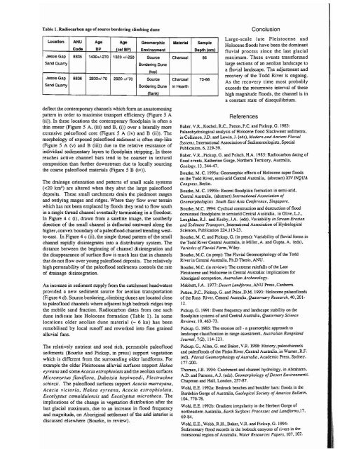
Table 1. Radiocarbon age ofsource border<strong>in</strong>g climb<strong>in</strong>g dune<br />
Location ANU Age Age Geomorphic Material Sample<br />
Code BP (cal BP) EnvIronment Del)th (eml<br />
Jessie Gap 8835 1430+/-270 1320+/·250 Source Charcoal 86<br />
SandQuany Border<strong>in</strong>g Dune<br />
Jessie Gap 8836 2830+/·70 2920 +/-70 Source Charcoal 75-88<br />
l<strong>to</strong>Dl<br />
Sand Quarry Border<strong>in</strong>g Dune <strong>in</strong> HeaI1h<br />
/flank\<br />
deflect the contemporary channels which form an anas<strong>to</strong>mos<strong>in</strong>g<br />
pattern <strong>in</strong> order <strong>to</strong> maximise transport efficiency (Figure 5 A<br />
(ii». In these locations the contemporary floodpla<strong>in</strong> is often a<br />
th<strong>in</strong> smear (Figure 5 A, (iii) and B, (i» over a laterally more<br />
extensive paleoflood core (Figure 5 A (iv) and B (ii». The<br />
morphology of exposed paleoflood sediment is often step-like<br />
(Figure 5 A (v) and B (iii» due <strong>to</strong> the relative resistance of<br />
<strong>in</strong>dividual sedimentary layers <strong>to</strong> floodpla<strong>in</strong> stripp<strong>in</strong>g. In these<br />
reaches active channel bars tend <strong>to</strong> be coarser <strong>in</strong> textural<br />
composition than further downstream due <strong>to</strong> locally sourc<strong>in</strong>g<br />
the coarse paleoflood materials (Figure 5 B (iv».<br />
The dra<strong>in</strong>age orientation and patterns of small scale systems<br />
«20 km 2 ) are altered when they abut the large paleoflood<br />
deposits. These small catchments dra<strong>in</strong> the piedmont ranges<br />
and outly<strong>in</strong>g ranges and ridges. Where they flow over terra<strong>in</strong><br />
which has not been emplaced by floods they tend <strong>to</strong> flow south<br />
<strong>in</strong> a s<strong>in</strong>gle thread channel eventually term<strong>in</strong>at<strong>in</strong>g <strong>in</strong> a floodout.<br />
In Figure 4 c (i), drawn from a satellite image, the southerly<br />
direction of the small channel is deflected eastward along the<br />
higher, convex boundary of a paleoflood channel trend<strong>in</strong>g west<strong>to</strong>-east.<br />
In Figure 4 c (ii), the s<strong>in</strong>gle thread pattern of the small<br />
channel rapidly dis<strong>in</strong>tegrates <strong>in</strong><strong>to</strong> a distributary system. The<br />
distance between the beg<strong>in</strong>n<strong>in</strong>g of channel dis<strong>in</strong>tegration and<br />
the disappearance of surface flow is much less that <strong>in</strong> channels<br />
that do not flow over young paleoflood deposits. The relatively<br />
high penneability of the paleoflood sediments controls the rate<br />
of dra<strong>in</strong>age dis<strong>in</strong>tegration.<br />
An <strong>in</strong>crease <strong>in</strong> sediment supply from the catchment headwaters<br />
provided a new sediment source for aeolian transportation<br />
(Figure 4 d). Source border<strong>in</strong>g, climb<strong>in</strong>g dunes are located close<br />
<strong>to</strong> paleoflood channels where adjacent high bedrock ridges trap<br />
the mobile sand fraction. Radiocarbon dates from One such<br />
dune <strong>in</strong>dicate late Holocene formation (Table 1). In some<br />
locations older aeolian dune material (- 6 ka) has been<br />
remobilised by local runoff and reworked <strong>in</strong><strong>to</strong> f<strong>in</strong>e gra<strong>in</strong>ed<br />
alluvial fans.<br />
The relatively nutrient and seed rich, permeable paleoflood<br />
sediments (Bourke and Pickup, <strong>in</strong> press) support vegetation<br />
which is different from the surround<strong>in</strong>g older landforms. For<br />
example the older Pleis<strong>to</strong>cene alluvial surfaces support Hakea<br />
eyreana and someAcacia estrophiolata and the aeolian surfaces<br />
Micromyrtus flaviflora, Duboisia hopiwoodi, Plectrachne<br />
sch<strong>in</strong>zii. The paleoflood surfaces support Acacia murrayana,<br />
Acacia vic<strong>to</strong>ria, Hakea eyreana, Acacia estrophiolara,<br />
Eucalyptus camaldulensis and Eucalyptus microtheca. The<br />
implications of the change <strong>in</strong> vegetation distribution after the<br />
last glacial maximum, due <strong>to</strong> an <strong>in</strong>crease <strong>in</strong> flood frequency<br />
and magnitude, on Aborig<strong>in</strong>al settlement of the arid <strong>in</strong>terior is<br />
discussed elsewhere (Bourke, <strong>in</strong> review).<br />
Conclusion<br />
Large-scale late Pleis<strong>to</strong>cene and<br />
Holocene floods have been the dom<strong>in</strong>ant<br />
fluvial process s<strong>in</strong>ce the last glacial<br />
maximum. These events transformed<br />
large sections of an aeolian landscape <strong>to</strong><br />
a fluvial landscape. The adjustment and<br />
recovery of the Todd River is ongo<strong>in</strong>g.<br />
As the recovery time most probably<br />
exceeds the recurrence <strong>in</strong>terval of these<br />
high magnitude floods, the channel is <strong>in</strong><br />
a COnstant state of disequilibrium.<br />
References<br />
Baker, VR., Kochel, R.C., Panon. P.C. and Pickup, G. 1983:<br />
Palaeohydrological analysis of Holocene flood Slackwater sediments,<br />
<strong>in</strong> Coll<strong>in</strong>son, JD. and Lew<strong>in</strong>. J. (cds), Modern and Ancient Fluvial<br />
Systems, International Association·of Sedimen<strong>to</strong>logists, Special<br />
Publication, 6, 229-39.<br />
Baker, V R., PickUp, G. and PoJach, H.A. 1985: Radiocarbon dat<strong>in</strong>g of<br />
flood events, Kather<strong>in</strong>e Gorge, Nonhern Terri<strong>to</strong>ry, Australia,<br />
Geology, 13,344-47.<br />
Bourke, M. C. 1995a: Geomorphic effects of Holocene super floods<br />
on the Todd River, semi-arid <strong>Central</strong> Australia, (abstract) XIV INQUA<br />
Congress, Berl<strong>in</strong>.<br />
Bourke, M. C. I 995b: Recent floodpla<strong>in</strong> formation <strong>in</strong> semi-arid,<br />
<strong>Central</strong> Australia, (abstract) Internati01Ul1 Association of<br />
Geomorphologists South East Asia Conference. S<strong>in</strong>gapore.<br />
Bourke. M.C. 1994: Cyclical construction and destruction of flood<br />
dom<strong>in</strong>ated floodpla<strong>in</strong>s <strong>in</strong> semiarid <strong>Central</strong> Australia, <strong>in</strong> Olive, LJ.,<br />
Loughlan, RJ. and Kesby, JA. (cds), Variability <strong>in</strong> Stream Erosion<br />
and Sediment Transport, International Association of Hydrological<br />
Sciences, Publication 224,113-23.<br />
Bourke, M. C. and Pickup, G. (<strong>in</strong> press): Variability of fluvial fonns <strong>in</strong><br />
the Todd River <strong>Central</strong> Australia, <strong>in</strong> Miller, A. and Gupta, A. (eds),<br />
Varieties ofFluvial Form, Wiley.<br />
Bourke. M.e. (<strong>in</strong> prep): The Fluvial Geomorphology of the Todd<br />
River <strong>in</strong> <strong>Central</strong> Australia. PhD Thesis, AND.<br />
Bourke. M.C. (<strong>in</strong> review): The extreme ra<strong>in</strong>falls of the Late<br />
Pleis<strong>to</strong>cene and Holocene <strong>in</strong> <strong>Central</strong> Australia: implications for<br />
Aborig<strong>in</strong>al occupation, Australian Archaeology.<br />
Mabbun,JA. 1977: Desert Landforms, AND Press, Canberra.<br />
Panen. P.C.. Pickup, G. and Price, OM. 1993: Holocene palaeofloods<br />
of the Ross River. <strong>Central</strong> Australia, Quater1Ulry Research. 40, 201<br />
12.<br />
Pickup. G. 1991: Event frequency and landscape stability on the<br />
floodpla<strong>in</strong> systems of arid <strong>Central</strong> Australia, Quaternary Science<br />
Reviews, 10,463·73.<br />
Pickup, G. 1985: The erosion cell - a geomorphic approaCh <strong>to</strong><br />
landscape classification <strong>in</strong> range assessment, Australian Rangeland<br />
Journal. 7(2), 114-121.<br />
Pickup, G., Allan, G. and Baker, VR. 1988: His<strong>to</strong>ry, paleochannels<br />
and paleofloods of the F<strong>in</strong>ke River, <strong>Central</strong> Australia, <strong>in</strong> Warner, R.F.<br />
(cd), Fluvial Geomorpholagy ofAustralia, Academic Press. Sydney.<br />
177-200.<br />
Thomes. J.B. 1994: Catchment and channel hydrology, <strong>in</strong> Abrahams.<br />
AD. and Parsons, AJ. (cds). Geomorphology ofDesert Environments,<br />
Chapman and Hall, London. 257-87.<br />
Wohl, E.E. 1992.3: Bedrock benches and boulder bars: floods <strong>in</strong> the<br />
Burdek<strong>in</strong> Gorge of Australia, Geological Society ofAmerica Bullet<strong>in</strong>,<br />
104.770-78.<br />
Wohl. E.E. 1992b: Gradient irregularity <strong>in</strong> the Herbert Gorge of<br />
nonheastern Australia, Earth Surfaces Processes and Landforms.17.<br />
69-84.<br />
Wohl, E.E., Webb, RR., Baker, VR. and Pickup, G. 1994:<br />
Sedimentary flood records <strong>in</strong> the bedrock canyons of rivers <strong>in</strong> the<br />
monsoonal region of Australia, Water Resources Papers, 107, 102.