inventario de infraestructuras en desuso en la cuenca del tajo
inventario de infraestructuras en desuso en la cuenca del tajo
inventario de infraestructuras en desuso en la cuenca del tajo

You also want an ePaper? Increase the reach of your titles
YUMPU automatically turns print PDFs into web optimized ePapers that Google loves.
INVENTARIO DE INFRAESTRUCTURAS EN DESUSO EN LA CUENCA DEL TAJO<br />
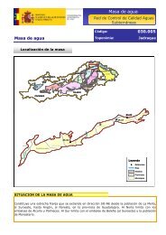
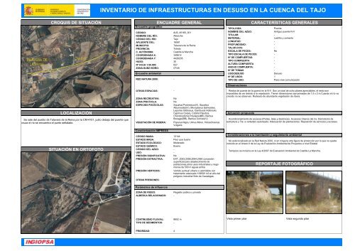
CROQUIS DE SITUACIÓN<br />
LOCALIZACIÓN<br />
Se sale <strong>de</strong>l pueblo <strong>de</strong> Ta<strong>la</strong>vera <strong>de</strong> <strong>la</strong> Reina por <strong>la</strong> CM-4101, justo <strong>de</strong>bajo <strong>de</strong>l pu<strong>en</strong>te que<br />
cruza el río se <strong>en</strong>cu<strong>en</strong>tra el punto seña<strong>la</strong>do.<br />
SITUACIÓN EN ORTOFOTO<br />
ENCUADRE GENERAL<br />
Encuadre geográfico<br />
CÓDIGO:<br />
ALB_45165_001<br />
NOMBRE DEL RÍO:<br />
Alberche<br />
CÓDIGO DEL RÍO:<br />
Tajo<br />
AFLUENTE DEL:<br />
16581<br />
MUNICIPIO:<br />
Ta<strong>la</strong>vera <strong>de</strong> <strong>la</strong> Reina<br />
PROVINCIA:<br />
Toledo<br />
C. AUTÓNOMA: Castil<strong>la</strong> <strong>la</strong> Mancha<br />
COORDENADA X: 349614<br />
COORDENADA Y: 4426235<br />
HUSO: 30<br />
Nº HOJA 1:50.000: 627<br />
ZONA-SUBZ HIDRO: 07/45<br />
Encuadre ambi<strong>en</strong>tal<br />
RED NATURA 2000: -<br />
OTROS ESPACIOS: -<br />
ZONA RECREATIVA:<br />
ZONA PISCÍCOLA:<br />
ESPECIES PISCÍCOLAS:<br />
VEGETACIÓN DE RIBERA:<br />
Caracterización IMPRESS<br />
No<br />
No<br />
Squalius Pyr<strong>en</strong>eicus(V), Squalius<br />
Alburnoi<strong>de</strong>s(V), Micropterus Salmoi<strong>de</strong>s,<br />
Lepomis Gibbosus, Gambusia Holbrooki,<br />
Cyprinus Carpio, Cobitis Paludica,<br />
Chondrostoma Polylepis(BR), Barbus<br />
Bocagei(BR), Barbus Comizo(V)<br />
Populus Nigra, Ulmus Minor, Holoscho<strong>en</strong>us<br />
Vulgaris<br />
CÓDIGO MASA: 12144<br />
ESTADO MASA:<br />
Peor que bu<strong>en</strong>o<br />
ESTADO ECOLÓGICO: Mo<strong>de</strong>rado<br />
ESTADO QUÍMICO:<br />
Bu<strong>en</strong>o<br />
CÓDIGO DEL AZUD: -<br />
USO: -<br />
PRESIÓN SIGNIFICATIVA: No<br />
PRESIÓN EXTRACTIVA: EXT_2053,2056,2064,2065 concesión<br />
superficial para abastecimi<strong>en</strong>to <strong>de</strong><br />
pob<strong>la</strong>ciones,otros usos industriales y riego<br />
m<strong>en</strong>os <strong>de</strong> 500 m aguas arriba<br />
PRESIÓN VERTIDOS:<br />
Vertido puntual urbano o asimi<strong>la</strong>ble con<br />
tratami<strong>en</strong>to a<strong>de</strong>cuado 109500 m3 al año <strong>de</strong>l<br />
poligono industrial Soto <strong>de</strong> Cazalegas.<br />
OTRAS PRESIONES: -<br />
CARACTERÍSTICAS GENERALES<br />
TIPOLOGÍA:<br />
Pu<strong>en</strong>te<br />
NOMBRE DEL AZUD:<br />
Antiguo pu<strong>en</strong>te N-V<br />
TITULAR: -<br />
MATERIAL:<br />
Ladrillo y cem<strong>en</strong>to<br />
LONGITUD: -<br />
PROFUNDIDAD: -<br />
TALUD (H/V): -<br />
ESCALA DE PECES:<br />
No<br />
TIPO ESCALA DE PECES: -<br />
Nº DE COMPUERTAS: -<br />
TIPO COMPUERTA -<br />
ALTURA COMPUERTA -<br />
ANCHO COMPUERTA: -<br />
Nº DE TOMAS -<br />
USO/DESUSO<br />
Desuso<br />
Nº DE USOS: 1<br />
TIPO DE USO:<br />
Paso vías comunicación<br />
Observaciones<br />
Restos <strong>de</strong> pu<strong>en</strong>te <strong>de</strong> <strong>la</strong> guerra <strong>en</strong> <strong>la</strong> N-V. Son un total <strong>de</strong> ocho pi<strong>la</strong>res apreciables, el resto son<br />
imposibles <strong>de</strong> ver <strong>de</strong>bido a <strong>la</strong> vegetación. Ti<strong>en</strong><strong>en</strong> dim<strong>en</strong>siones aproximadas <strong>de</strong> 1.5 x 2 m.Cuando el río va<br />
crecido no se observan. Ro<strong>de</strong>ado <strong>de</strong> abundante vegetación <strong>de</strong> ribera.<br />
Actuación propuesta<br />
Acondicionami<strong>en</strong>to <strong>de</strong> accesos (Podas, ta<strong>la</strong>s y <strong>de</strong>sbroces. Accesos); Desvío <strong>de</strong>l río; Demolición <strong>de</strong><br />
estructura y Tte. a verte<strong>de</strong>ro autorizado; A<strong>de</strong>cuación <strong>de</strong> p<strong>la</strong>ntaciones. Reposición <strong>de</strong> servicios y accesos.<br />
Consi<strong>de</strong>raciones a <strong>la</strong> tramitación y seguimi<strong>en</strong>to ambi<strong>en</strong>tal<br />
No está localizado <strong>en</strong> <strong>la</strong> Red Natura 2000, ni <strong>en</strong> ninguna otra figura <strong>de</strong> protección por lo que no queda<br />
incluido <strong>en</strong> el Anexo II <strong>de</strong> <strong>la</strong> Ley <strong>de</strong> Evaluación Ambi<strong>en</strong>tal <strong>de</strong> Proyectos a nivel Estatal.<br />
Tampoco se incluiría <strong>en</strong> <strong>la</strong> Ley 4/2007 <strong>de</strong> Evaluación Ambi<strong>en</strong>tal <strong>de</strong> Castil<strong>la</strong> La Mancha.<br />
REPORTAJE FOTOGRÁFICO<br />
Parámetros <strong>de</strong> influ<strong>en</strong>cia<br />
ZONA DE RIEGO:<br />
Regadío público y privado<br />
ALBERCA RELACIONADO: -<br />
CONTINUIDAD FLUVIAL: 8652 m<br />
TIPO DE SEDIMENTOS: -<br />
Vista primer pi<strong>la</strong>r<br />
Vista segundo pi<strong>la</strong>r<br />
PRIORIDAD: 4