RECEPTOR DE GIS Y MAPPING - Topcon Positioning
RECEPTOR DE GIS Y MAPPING - Topcon Positioning
RECEPTOR DE GIS Y MAPPING - Topcon Positioning

Create successful ePaper yourself
Turn your PDF publications into a flip-book with our unique Google optimized e-Paper software.
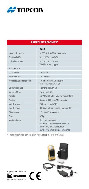
ESPECIFICACIONES*GMS-2Número de canales50 GPS+GLONASS L1 seguimientoPrecisión DGPS50 cm HECM (Hor-RMS)L1 función estáticaH: ECM 3 mm + 0,8 ppmV: ECM 4 mm + 1,0 ppmWAAS/EGNOSSiCORS beaconSi con BR-1Memoria internaFlash 256 MBProcesador/sistema operativo 520 MHz Intel PXA270 Bulverde /Microsoft Windows CE ® 5.0Software OnboardTopPAD o TopSURV-<strong>GIS</strong>Software Office<strong>Topcon</strong> Tools <strong>GIS</strong>Pantalla3.5” 240 x 320 color QVGA con pantalla táctilPuertosBluetooth, USB, serie, ANT y energíaVida de la batería7.5 horas en modo GPSTipo de bateríaBatería de Li-Ion recargable / reemplazableDimensiones197 mm x 90 mm x 46 mmPeso0,7 KgMedioambientalIP66, 1 metro en caída-20º a +50ºC temperatura de operación-10º a +50ºC utilizando la cámara-30º a +60ºC temperatura de almacenaje* Todos los cambios técnicos están reservados por <strong>Topcon</strong>, 01/2007