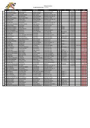
VIII SUBIDA ALISAS - Subida de Alisas
VIII SUBIDA ALISAS - Subida de Alisas
VIII SUBIDA ALISAS - Subida de Alisas
- No tags were found...

Create successful ePaper yourself
Turn your PDF publications into a flip-book with our unique Google optimized e-Paper software.
MAPA<strong>SUBIDA</strong> A <strong>ALISAS</strong>Carretera AUTONÓMICA CA- 261 <strong>de</strong> la Cavada al Puerto <strong>de</strong> <strong>Alisas</strong> y Arredondo.Salida: Bº Los Caminucos punto kilométrico 5.200 Altitud 180 m.Llegada: Mirador <strong>de</strong> <strong>Alisas</strong> punto kilométrico 12.400 Altitud 674 m.Longitud: 7.200 metros.HORARIOS:14/07/1211.00 Entrenamientos libres <strong>ALISAS</strong>SeguidoSeguidoEntrenamientos oficiales1ª <strong>Subida</strong> Oficial<strong>ALISAS</strong><strong>ALISAS</strong>Seguido 2ª <strong>Subida</strong> Oficial <strong>ALISAS</strong>La carrera se disputará a dos mangas, siendo obligatorio llevar el vehículo alparque cerrado <strong>de</strong> final <strong>de</strong> carrera.La clasificación se confeccionará con la suma <strong>de</strong>l tiempo realizado en las dosmangas oficiales <strong>de</strong> carrera.