

Revista Nº. 1 - Mayo 2013 - EOI Sagunt
Revista Nº. 1 - Mayo 2013 - EOI Sagunt
Revista Nº. 1 - Mayo 2013 - EOI Sagunt

Create successful ePaper yourself
Turn your PDF publications into a flip-book with our unique Google optimized e-Paper software.
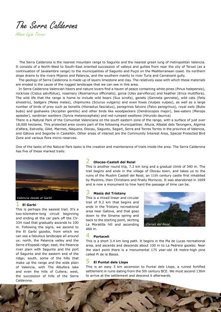
INDICEThe Serra CalderonaAlonso Luján TorresEl Ricón del ArtistaObras de Diógenes AlarcónThe Serra Calderona is the nearest mountain range to <strong>Sagunt</strong>o and the nearest green lung of metropolitan Valencia.It consists of a North-West to South-East oriented succession of valleys and gullies from near the city of Teruel (as acontinuation of Javalambre range) to the municipalities of <strong>Sagunt</strong>o and Puçol on the Mediterranean coast. Its northernslope drains to the rivers Mijares and Palancia, and the southern mainly to river Turia and Carraixent gully.The geology of Serra Calderona is made up of layers limestone and clay. The relatively ease with which these materialsare eroded is the cause of the rugged landscape that we can see in this area.In Serra Calderona Valencian hikers and nature lovers find a haven of peace containing white pines (Pinus halepensis),rockrose (Cistus salvifolius), rosemary (Rosmarinus officinalis), gorse (Ulex parviflorus) and heather (Erica multiflora).The wild life that the range is home to include wild boars (Sus scrofa), genets (Genneta genneta), wild cats (Felissilvestris), badgers (Meles meles), chipmunks (Sciurus vulgaris) and even foxes (Vulpes vulpes), as well as a largenumber of birds of prey such as bonellis (Hieraetus fasciatus), peregrines falcons (Falco peregrinus), royal owls (Bubobubo) and goshawks (Accipiter gentilis) and other birds like woodpeckers (Dendrocopos major), bee-eaters (Meropsapiaster), sardinian warblers (Sylvia melanocephala) and red-rumped swallows (Hirundo daurica)There is a Natural Park of the Comunitat Valenciana on the south eastern zone of the range, with a surface of just over18,000 hectares. This protected area covers part of the following municipalities: Altura, Albalat dels Tarongers, Algimiad’alfara, Estivella, Gilet, Marines, Nàquera, Olocau, <strong>Sagunt</strong>o, Segart, Serra and Torres Torres in the province of Valencia,and Gàtova and Segorbe in Castellón. Other areas of interest are the Community Interest Area, Special Protected BirdZone and various flora micro-reserves.One of the tasks of the Natural Park tasks is the creation and maintenance of trails inside the area. The Serra Calderonahas five of these marked trails:Valencia desde el Garbí1El GarbíThis is perhaps the easiest trail. It’s atwo-kilometre-long circuit beginningand ending at the car park off the CV-334 road that gradually ascends to 100m. Following the signs, we ascend tothe El Garbí gazebo, from which wecan see a fabulous landscape all aroundus: north, the Palancia valley and theSerra d’Espadá ridge; east, the Palanciariver plain with <strong>Sagunt</strong>o and the portof <strong>Sagunt</strong>o and the eastern end of theridge; south, some of the hills thatmake up the range and the wide plainof Valencia, with The Albufera lakeand even the hills of Cullera; west,the succession of hills of the SerraCalderona.2Olocao-Castell del ReialThis is another round trip, 7.2 km long and a gradual climb of 340 m. Thetrail begins and ends in the village of Olocau town, and takes us to theruins of the Muslim Castell del Reial, an 11th century castle first inhabitedby Muslims, then Christians and finally Moriscos. It was abandoned in 1609and is now a monument to how hard the passage of time can be.3Masia del TristanyThis is a mixed linear and circulartrail of 9.2 km that begins andends in the Tristany recreationalarea near Gatova, and that goesdown to the Sinaina spring andback to the starting point, skirtingLa Moratilla hill and ascending460 m.4PortaceliThis is a short 3.4 km long path. It begins in the Pla de Lucas recreationalarea, and ascends and descends about 100 m to La Pedrera gazebo. Nearthe start point there is a monumental 175 year-old 18 metre-high pinecalled Pi de la Bassa.5Cartell del ReialEl Puntal dels LlopsThis is an easy 3 km ascension to Puntal dels Llops, a ruined fortifiedsettlement in ruins dating from the 5th century BCE. We must ascend 136mto arrive at the settlement and descend it afterwards.Un artista entre nosotrosPág. 28