Senderos de Alicante
Senderos de Alicante
Senderos de Alicante

You also want an ePaper? Increase the reach of your titles
YUMPU automatically turns print PDFs into web optimized ePapers that Google loves.
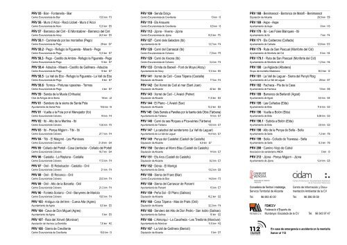
PRV 55 · Biar - Fontanella - Biar<br />
Centro Excursionista <strong>de</strong> Biar 15,5 km · F3<br />
PRV 56 · Muro d´Alcoi - Racó Llobet - Muro d´Alcoi<br />
Centro Excursionista <strong>de</strong> Muro 12,5 km · E5<br />
PRV 57 · Barranco <strong>de</strong>l Cint - El Montcabrer - Barranco <strong>de</strong>l Cint<br />
Centro Excursionista <strong>de</strong> Alcoy 24,5 km · E5<br />
PRV 58.1 · Caminando por las montañas (Pego)<br />
Centro Excursionista <strong>de</strong> Pego 29 km · D7<br />
PRV 58.2 · Pego - Refugio la Figuereta - Miserà - Pego<br />
Centro Excursionista <strong>de</strong> Pego 12,5 km · D7<br />
PRV 58.3 · Pego - Castillo <strong>de</strong> Ambra - Refugio la Figuereta - Pego<br />
Centro Excursionista <strong>de</strong> Pego 13 km · D7<br />
PRV 58.4 · Adsubia - Miserà - Castillo <strong>de</strong> Gallinera - Adsubia<br />
Centro Excursionista <strong>de</strong> Pego 10 km · D7<br />
PRV 58.5 · La Vall <strong>de</strong> Ebo - Refugio la Figuereta - La Vall <strong>de</strong> Ebo<br />
Centro Excursionista <strong>de</strong> Pego 8 km · D7<br />
PRV 58.6 · Tormos - Pinturas rupestres - Tormos<br />
Centro Excursionista <strong>de</strong> Pego 4 km · D7<br />
PRV 59 · Senda <strong>de</strong> la Muela (Orihuela)<br />
Club <strong>de</strong> Amigos <strong>de</strong> la Sierra 16 km · J2<br />
PRV 61 · Sen<strong>de</strong>ro <strong>de</strong> la sierra <strong>de</strong> Santa Pola<br />
Ayuntamiento <strong>de</strong> Santa Pola 10,6 km · I5<br />
PRV 81 · Vuelta a la Foia por el Menejador (Ibi)<br />
Centro Excursionista Colivenc 18 km · F4<br />
PRV 82 · Ibi - Alto <strong>de</strong> la Martina - Ibi<br />
Centro Excursionista Colivenc 13,6 km · F5<br />
PRV 83 · Ibi - Penya Migjorn - Tibi - Ibi<br />
Centro Excursionista Colivenc 27,7 km · F4<br />
PRV 84 · Tibi - El Maigmó - Les Planisses<br />
Centro Excursionista Colivenc 21,9 km · G4<br />
PRV 85 · Collado <strong>de</strong>l Portell - Casa Llentisclar - Collado <strong>de</strong>l Portell<br />
Centro Excursionista Colivenc 19,7 km · G4<br />
PRV 86 · Castalla - La Replana - Castalla<br />
Centro Excursionista Colivenc 17,5 km · F4<br />
PRV 87 · Onil - El Rebolcador - Castalla - Onil<br />
Centro Excursionista Colivenc 21 km · F4<br />
PRV 88 · Onil - El Reconco - Onil<br />
Centro Excursionista Colivenc 20,5 km · F4<br />
PRV 89 · Onil - Alto <strong>de</strong> la Barcella - Onil<br />
Centro Excursionista Colivenc 21,3 km · F4<br />
PRV 90 · Fonteta Soriano - Onil - Banyeres <strong>de</strong> Mariola<br />
Centro Excursionista Colivenc 18,5 km · F4<br />
PRV 103 · Antigua vía <strong>de</strong>l tren - Cueva Alta (Agres)<br />
Ayuntamiento <strong>de</strong> Agres 8,5 km · E5<br />
PRV 104 · Cava <strong>de</strong> Don Miguel (Agres)<br />
Ayuntamiento <strong>de</strong> Agres 5 km · E5<br />
PRV 107 · Ruta <strong>de</strong>l Xirivell (Monóvar)<br />
Asociación <strong>de</strong> Vecinos La Bombilla 7,6 km · H2<br />
PRV 108 · Sierra <strong>de</strong> Crevillente<br />
Centro Excursionista <strong>de</strong> Crevillente 16,9 km · I3<br />
PRV 109 · Senda Dolça<br />
Centro Excursionista <strong>de</strong> Crevillente 13 km · I3<br />
PRV 110 · Els Anouers<br />
Centro Excursionista <strong>de</strong> Crevillente 8,5 km · I3<br />
PRV 112 · Jijona - Vivens - Jijona<br />
Centro Excursionista <strong>de</strong> Jijona 16,5 km · F5<br />
PRV 127 · Camí <strong>de</strong>ls Geladors (Ibi)<br />
Ayuntamiento <strong>de</strong> Ibi 13,7 km · F4<br />
PRV 128 · Camí <strong>de</strong>l Carrascal (Ibi)<br />
Centro Excursionista <strong>de</strong> Colivenc 7,5 km · F5<br />
PRV 129 · Camí <strong>de</strong> Xixona (Ibi)<br />
Centro Excursionista <strong>de</strong> Colivenc 3,4 km · F4<br />
PRV 133 · Ermita <strong>de</strong> Barxell - Font <strong>de</strong> Moya (Alcoy)<br />
Ayuntamiento <strong>de</strong> Alcoy 11,5 km · E5<br />
PRV 141 · Xorret <strong>de</strong> Catí - Casa Tàpena (Castalla)<br />
Diputación <strong>de</strong> <strong>Alicante</strong> 17 km · F4<br />
PRV 142 · Del Xorret <strong>de</strong> Catí al mar (Sant Joan)<br />
Diputación <strong>de</strong> <strong>Alicante</strong> 42 km · G5<br />
PRV 143 · Xorret <strong>de</strong> Catí - L’Avaiol (Petrer)<br />
Diputación <strong>de</strong> <strong>Alicante</strong> 11,5 km · G3<br />
PRV 144 · El Plano - L’Avaiol (Sax)<br />
Diputación <strong>de</strong> <strong>Alicante</strong> 12,2 km · G3<br />
PRV 145 · Dels Serrals a Parelles por la fuente <strong>de</strong>ls Olbis (Tàrbena)<br />
Ayuntamiento <strong>de</strong> Tàrbena 14 km · E7<br />
PRV 146 · Camí <strong>de</strong> ses Roques a Pica-sàries (Tàrbena)<br />
Ayuntamiento <strong>de</strong> Tàrbena 10,5 km · E7<br />
PRV 147 · La catedral <strong>de</strong>l sen<strong>de</strong>rismo (La Vall <strong>de</strong> Laguar)<br />
Ayuntamiento <strong>de</strong> La Vall <strong>de</strong> Laguar 14,4 km · E7<br />
PRV 149 · Penya <strong>de</strong>l Castellet (Castell <strong>de</strong> Castells)<br />
Diputación <strong>de</strong> <strong>Alicante</strong> 8,9 km · E7<br />
PRV 150 · Sen<strong>de</strong>ro al Morro Blau (Castell <strong>de</strong> Castells)<br />
Diputación <strong>de</strong> <strong>Alicante</strong> 14 km · E7<br />
PRV 151 · Els Arcs (Castell <strong>de</strong> Castells)<br />
Diputación <strong>de</strong> <strong>Alicante</strong> 9,2 km · E7<br />
PRV 152 · Dénia - El Montgó<br />
Ayuntamiento <strong>de</strong> Dénia 10,2 km · E8<br />
PRV 155 · Sierra <strong>de</strong>l Frare (Biar)<br />
Centro Excursionista <strong>de</strong> Biar 14,6 km · F3<br />
PRV 158 · Sierra <strong>de</strong>l Carrascar <strong>de</strong> Parcent<br />
Ayuntamiento <strong>de</strong> Parcent 15 km · E7<br />
PRV 159 · Peña Sol - El Plano (Salinas)<br />
Diputación <strong>de</strong> <strong>Alicante</strong> 16,2 km · G2<br />
PRV 160 · Casa Tàpena - Mas <strong>de</strong> Prats (Onil)<br />
Diputación <strong>de</strong> <strong>Alicante</strong> 32,3 km · F4<br />
PRV 165 · Sen<strong>de</strong>ro <strong>de</strong>l Alto <strong>de</strong> Don Pedro - San Isidro (Salinas)<br />
Ayuntamiento <strong>de</strong> Salinas 10 km · G2<br />
PRV 166 · L’Almorquí - La Cavafreda - Les Tresfonts (Monóvar)<br />
Ayuntamiento <strong>de</strong> Monóvar 11,9 km · H2<br />
PRV 167 · La Vall <strong>de</strong> Gallinera (Benialí)<br />
Diputación <strong>de</strong> <strong>Alicante</strong> 5 km · D7<br />
PRV 168 · Benimassot - Barranco <strong>de</strong> Malafí - Benimassot<br />
Diputación <strong>de</strong> <strong>Alicante</strong> 29,5 km · E6<br />
PRV 169 · Aspe - Aspe<br />
Ayuntamiento <strong>de</strong> Aspe 9 km · H3<br />
PRV 170 · Ibi - Les Foies Blanques - Ibi<br />
Ayuntamiento <strong>de</strong> Ibi 7 km · F4<br />
PRV 171 · Els Cal<strong>de</strong>rons (Cañada)<br />
Ayuntamiento <strong>de</strong> Cañada 12,8 km · E3<br />
PRV 179 · Ruta <strong>de</strong> San Pascual (Monforte <strong>de</strong>l Cid)<br />
Ayuntamiento <strong>de</strong> Monforte <strong>de</strong>l Cid 8 km · H4<br />
PRV 179.1 · Ruta <strong>de</strong> San Pascual (Monforte <strong>de</strong>l Cid)<br />
Ayuntamiento <strong>de</strong> Monforte <strong>de</strong>l Cid 1,2 km · H4<br />
PRV 180 · La Algüeda (Albatera)<br />
Grupo <strong>de</strong> montaña Albaterano 30,5 km · I2<br />
PRV 181 · La Vall <strong>de</strong> Laguar - Sierra <strong>de</strong>l Penyó Roig<br />
Ayuntamiento <strong>de</strong> La Vall <strong>de</strong> Laguar 25 km · E7<br />
PRV 182 · Facheca - Pla <strong>de</strong> la Casa<br />
Ayuntamiento <strong>de</strong> Facheca 13 km · E6<br />
PRV 189 · Barranco <strong>de</strong> Berlandí (Agost)<br />
Ayuntamiento <strong>de</strong> Agost 5,5 km · G4<br />
PRV 195 · Las Cañadas (Elda)<br />
Ayuntamiento <strong>de</strong> Elda 11,6 km · G3<br />
PRV 196 · Vuelta a Bolón (Elda)<br />
Ayuntamiento <strong>de</strong> Elda 6,59 km · G3<br />
PRV 196.1 · Subida a Bolón (Elda)<br />
Ayuntamiento <strong>de</strong> Elda 3,9 km · G3<br />
PRV 198 · Alto <strong>de</strong> la Penya <strong>de</strong> Sella - Sella<br />
Ayuntamiento <strong>de</strong> Sella 7,2 km · F6<br />
PRV 199 · Sella - Collado <strong>de</strong> Travessa - Sella<br />
Ayuntamiento <strong>de</strong> Sella 8,3 km · F6<br />
PRV 208 · Camino Viejo <strong>de</strong> Catral<br />
Asociacion <strong>de</strong> sen<strong>de</strong>rismo ANDA 5 km · I3<br />
PRV 212 · Jijona - Penya Migjorn - Jijona<br />
Ayuntamiento <strong>de</strong> Jijona 12,4 km · G5<br />
Conselleria <strong>de</strong> Territori i Habitatge,<br />
Servicio Territorial <strong>de</strong> <strong>Alicante</strong><br />
Tel. 96 593 40 00<br />
F.E.M.E.C.V.<br />
Centro <strong>de</strong> Información y Documentación<br />
Ambiental <strong>de</strong> la CV<br />
Tel. 96 386 58 58<br />
FEMECV<br />
Fe<strong>de</strong>ració d’Esports <strong>de</strong><br />
Muntanya i Escalada <strong>de</strong> la CV Tel. 96 543 97 47<br />
En caso <strong>de</strong> emergencia o acci<strong>de</strong>nte en la montaña<br />
llamar al 112
![Ficha UE-17 a 48, 50 y 56 [PDF]](https://img.yumpu.com/14783743/1/184x260/ficha-ue-17-a-48-50-y-56-pdf.jpg?quality=85)
![Anejo 10: Agua Potable [PDF]](https://img.yumpu.com/14296713/1/184x260/anejo-10-agua-potable-pdf.jpg?quality=85)