Berliinin maankäyttöyleiskaava - Helsingin kaupunki
Berliinin maankäyttöyleiskaava - Helsingin kaupunki
Berliinin maankäyttöyleiskaava - Helsingin kaupunki

You also want an ePaper? Increase the reach of your titles
YUMPU automatically turns print PDFs into web optimized ePapers that Google loves.
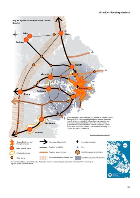
Map 13. Spatial vision for Eastern Central<br />
Sweden<br />
N<br />
Greater Stockholm and<br />
the regional cores<br />
Major network towns<br />
Collaboration areas<br />
Other towns<br />
Key regional travel links<br />
Regional travel links<br />
Regional goods structure<br />
Main route for national goods flows<br />
The spatial vision is a spatial view of the future for Eastern Central<br />
Sweden in 2050. It is intended to facilitate a common discussion<br />
regarding how the markets for labour, housing, education and<br />
entrepreneurship can be tied together. The spatial vision is a<br />
platform for broader collaboration. Map 14 illustrates a greater<br />
regional city structure in Eastern Central Sweden and Map 15 a<br />
greater regional goods structure.<br />
International airports<br />
The selection of towns (presented in the diagram) is based on the current population size, forecasts and the proximity to<br />
regional routes and to Stockholm.<br />
Port<br />
0 10 20 30 40 50 km<br />
Stockholm's outer terminal sites<br />
Stockholm's outer commuter zone<br />
Itäisen Keski-Ruotsin spatiaalivisio<br />
91