Les risques qui interfèrent sur l'urbanisation - Ville de Clichy
Les risques qui interfèrent sur l'urbanisation - Ville de Clichy
Les risques qui interfèrent sur l'urbanisation - Ville de Clichy

Create successful ePaper yourself
Turn your PDF publications into a flip-book with our unique Google optimized e-Paper software.
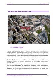
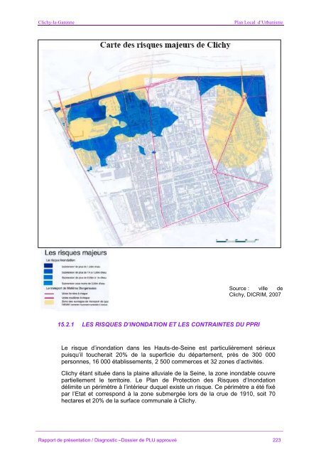
<strong>Clichy</strong>-la-GarennePlan Local d’UrbanismeSource : ville <strong>de</strong><strong>Clichy</strong>, DICRIM, 200715.2.1 LES RISQUES D’INONDATION ET LES CONTRAINTES DU PPRILe risque d’inondation dans les Hauts-<strong>de</strong>-Seine est particulièrement sérieuxpuisqu’il toucherait 20% <strong>de</strong> la superficie du département, près <strong>de</strong> 300 000personnes, 16 000 établissements, 2 500 commerces et 32 zones d’activités.<strong>Clichy</strong> étant située dans la plaine alluviale <strong>de</strong> la Seine, la zone inondable couvrepartiellement le territoire. Le Plan <strong>de</strong> Protection <strong>de</strong>s Risques d’Inondationdélimite un périmètre à l’intérieur duquel existe un risque. Ce périmètre a été fixépar l’Etat et correspond à la zone submergée lors <strong>de</strong> la crue <strong>de</strong> 1910, soit 70hectares et 20% <strong>de</strong> la <strong>sur</strong>face communale à <strong>Clichy</strong>.Rapport <strong>de</strong> présentation / Diagnostic –Dossier <strong>de</strong> PLU approuvé 223