Vegetation of Girraween National Park - Flora ... - www.rymich.com!
Vegetation of Girraween National Park - Flora ... - www.rymich.com!
Vegetation of Girraween National Park - Flora ... - www.rymich.com!

You also want an ePaper? Increase the reach of your titles
YUMPU automatically turns print PDFs into web optimized ePapers that Google loves.
<strong>Girraween</strong> <strong>National</strong> <strong>Park</strong> en<strong>com</strong>passes some areas that are not considered remnant vegetation. These<br />
are areas that before amalgamation with the park were used for farming or orchards. These non-remnant<br />
areas are being managed or rehabilitated using a <strong>com</strong>bination <strong>of</strong> Assisted Natural Regeneration (with weed<br />
control and fire being the primary interventions) or revegetation using local provenance plants raised in a<br />
nursery (QPWS 2010).<br />
Management strategies and objectives that aim to preserve the <strong>Park</strong>’s unique vegetation <strong>com</strong>munities<br />
and flora, and mitigate identified threatening processes are detailed within the <strong>Girraween</strong> <strong>National</strong> <strong>Park</strong><br />
Management Plan 2010 (QPWS 2010).<br />
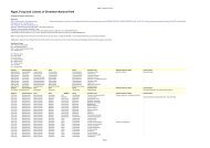
Figure 1 Composition <strong>of</strong> the <strong>Park</strong>’s Remnant Regional Ecosystems and non-remnant vegetation<br />
It is important that the goals and scale <strong>of</strong> Regional Ecosystem mapping are kept in mind when<br />
interpreting the graph above. Queensland Regional Ecosystems are a landscape scale mapping and<br />
classification framework. For most areas <strong>of</strong> Queensland, the Regional Ecosystem mapping and classification<br />
is at a scale <strong>of</strong> 1:100,000 4 (Neldner, et al. 2005) and this limits the amount <strong>of</strong> information that is<br />
represented. This is not a design fault <strong>of</strong> the mapping methodology as the framework was designed as a<br />
tool to work at the landscape scale. At finer scales, the differences between vegetation <strong>com</strong>munities are<br />
more <strong>com</strong>plex and diverse than the regional ecosystem framework provides.<br />
4 Some areas <strong>of</strong> Queensland are mapped at a scale <strong>of</strong> 1:50,000<br />
<strong>Vegetation</strong> <strong>of</strong> <strong>Girraween</strong> <strong>National</strong> <strong>Park</strong>, July 2011<br />
Page 13