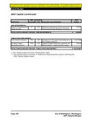
Woodstock Master Plant List - City of Bellingham, WA
Woodstock Master Plant List - City of Bellingham, WA
Woodstock Master Plant List - City of Bellingham, WA

Create successful ePaper yourself
Turn your PDF publications into a flip-book with our unique Google optimized e-Paper software.
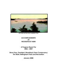
Location Codes (see map on next page)<br />
On Farm Site<br />
BC Building compound yards, beds and edges<br />
BP Beach Pasture, includes shore-slump wetland<br />
BPW Beach Pasture Woody Margin (AKA North Point shoreline)<br />
CCM Chuckanut Creek Saltmarsh Strip<br />
CLU Cliff and ledges outside UBR fence (Windlift Cliff) and slopes below Inspiration Point<br />
CLL Cliff and ledges outside LBP fence<br />
CLW Cliffs and ledges outside WPM fence and W <strong>of</strong> OBR<br />
DW Driveway corridor; SR 11 highway to Cook's House and cleared ptn. <strong>of</strong> Kopperdahl Knoll<br />
KDW Kopperdahl Woods<br />
LBP Lower Bluff Pasture<br />
OBR Old Boat House Ravine, includes wetland and drier slopes<br />
OBM Old Boat House Ravine Saltmarsh<br />
OP Orchard Pasture and wooded highway fringe<br />
WCF <strong>Woodstock</strong> Creek Highway Fill<br />
WCR <strong>Woodstock</strong> Creek Ravine<br />
WPM West Point Meadow<br />
UBR Upper Bluff Ridge (includes N slope forest & W exposed meadow areas)<br />
NE Chuckanut Bay Off <strong>of</strong> Farm Site<br />
CBNU North Shore Uplands, incudes Jones property<br />
CBNB North Shore Backshore, Upper Beach & Spray Zone, includes Jones property shoreline<br />
CCM Chuckanut Creek Saltmarsh<br />
CLPS Clark Point pocket beaches and spray zone<br />
CLPU Clark Point uplands<br />
CVU Chuckanut Village Uplands adjacent to bay shore<br />
CVWF Chuckanut Village Wetland, freshwater<br />
CVWS Chuckanut Village Wetland, brackish meadow area, beach berm & upper beach N <strong>of</strong> marsh ditch<br />
OKW Okanogan Street Wetland<br />
OGW Owl Gallery Woods