Analisi radar e GPS per lo studio dei ghiacciai Alpini
Analisi radar e GPS per lo studio dei ghiacciai Alpini
Analisi radar e GPS per lo studio dei ghiacciai Alpini
- No tags were found...

You also want an ePaper? Increase the reach of your titles
YUMPU automatically turns print PDFs into web optimized ePapers that Google loves.
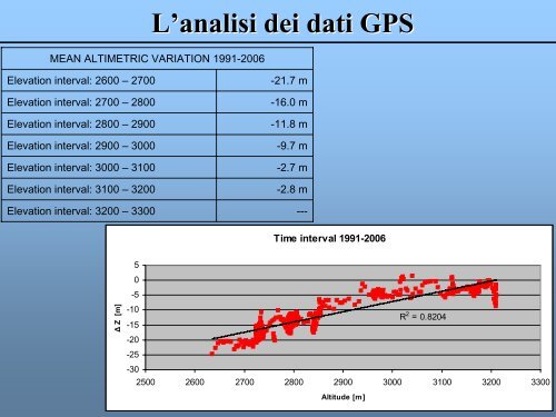
L’analisi <strong>dei</strong> dati <strong>GPS</strong>MEAN ALTIMETRIC VARIATION 1991-2006Elevation interval: 2600 – 2700Elevation interval: 2700 – 2800Elevation interval: 2800 – 2900Elevation interval: 2900 – 3000Elevation interval: 3000 – 3100Elevation interval: 3100 – 3200-21.7 m-16.0 m-11.8 m-9.7 m-2.7 m-2.8 mElevation interval: 3200 – 3300 ---Time interval 1991-200650-5Δ Z [m]-10-15R 2 = 0.8204-20-25-302500 2600 2700 2800 2900 3000 3100 3200 3300Altitude [m]