fibel-it-low

You also want an ePaper? Increase the reach of your titles
YUMPU automatically turns print PDFs into web optimized ePapers that Google loves.
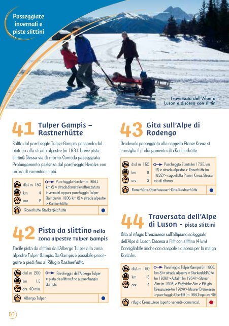
Passeggiate<br />
invernali e<br />
piste sl<strong>it</strong>tini<br />
Traversata dell’Alpe di<br />
Luson e discesa con sl<strong>it</strong>tini<br />
41<br />
Tulper Gampis –<br />
43<br />
Rastnerhütte<br />
Sal<strong>it</strong>a dal parcheggio Tulper Gampis, passando dal<br />
biotopo, alla strada alpestre (m 1931, breve pista<br />
sl<strong>it</strong>tini). Stessa via di r<strong>it</strong>orno. Comoda passeggiata.<br />
Prolungamento: partenza dal parcheggio Heroler, con<br />
un'ora di cammino in piú.<br />
50<br />
disl. .m. 150<br />
Parcheggio Heroler (m 1650,<br />
km 6) > strada forestale (attrezzatura<br />
km 4 invernale), oppure parcheggio Tulper<br />
ore 2<br />
Gampis (m 1806, km 8) > strada alpestre<br />
> Rastnerhütte.<br />
Ronerhütte, Starkenfeldhütte<br />
42<br />
Pista da sl<strong>it</strong>tino nella<br />
zona alpestre Tulper Gampis<br />
Facile pista da sl<strong>it</strong>tino dall'Albergo Tulper alla zona<br />
alpestre Tulper Gampis. Da Gampis è possibile proseguire<br />
a piedi fino al Rifugio Rastnerhütte.<br />
disl. .m. 200<br />
km 1,5<br />
ore 40 min.<br />
Albergo Tulper<br />
Parcheggio dell'Albergo Tulper<br />
> pista da sl<strong>it</strong>tino fino al parcheggio<br />
Gampis<br />
G<strong>it</strong>a sull’Alpe di<br />
Rodengo<br />
Gradevole passeggiata alla cappella Pianer Kreuz, si<br />
consiglia il prolungamento alla Rastnerhütte.<br />
disl. m. 150<br />
km 8<br />
ore 3<br />
Parcheggio Zumis (m 1735, km<br />
12) > strada alpestre > Ronerhütte (m<br />
1832) > cappelletta Pianer Kreuz. Stessa<br />
via di r<strong>it</strong>orno<br />
Ronerhütte, Oberhasuser Hütte, Rastnerhütte<br />
44<br />
Traversata dell’Alpe<br />
di Luson - pista sl<strong>it</strong>tini<br />
G<strong>it</strong>a al rifugio Kreuzwiese sull'altipiano soleggiato<br />
dell'Alpe di Luson. Discesa a Fl<strong>it</strong>t con sl<strong>it</strong>tino (4 km).<br />
Consigliabile anche con ciaspole e discesa per la malga<br />
Kostalm.<br />
disl. m. 150 Parcheggio Tulper Gampis (m 1806,<br />
km 13<br />
km 8) > strada alpestre > Starkenfeldhütte<br />
(m 1936) > Astalm (m 1954) > Steiner<br />
ore 4 Alm (m 1908) > Raffreider Alm > Rifugio<br />
Kreuzwiese (m 1924) > Maurer Dreiwiesen<br />
> parcheggio Oberfl<strong>it</strong>t (m 1650) oppure Fl<strong>it</strong>t<br />
rifugio Kreuzwiese (aperto venerdì-domenica).