Download the complete Map - Consorzio del Vino Brunello di ...
Download the complete Map - Consorzio del Vino Brunello di ...
Download the complete Map - Consorzio del Vino Brunello di ...

You also want an ePaper? Increase the reach of your titles
YUMPU automatically turns print PDFs into web optimized ePapers that Google loves.
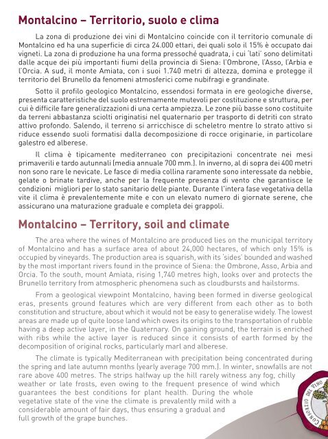
Montalcino – Territorio, suolo e clima<br />
La zona <strong>di</strong> produzione dei vini <strong>di</strong> Montalcino coincide con il territorio comunale <strong>di</strong><br />
Montalcino ed ha una superficie <strong>di</strong> circa 24.000 ettari, dei quali solo il 15% è occupato dai<br />
vigneti. La zona <strong>di</strong> produzione ha una forma pressoché quadrata, i cui ‘lati’ sono <strong>del</strong>imitati<br />
dalle acque dei più importanti fiumi <strong>del</strong>la provincia <strong>di</strong> Siena: l’Ombrone, l’Asso, l’Arbia e<br />
l’Orcia. A sud, il monte Amiata, con i suoi 1.740 metri <strong>di</strong> altezza, domina e protegge il<br />
territorio <strong>del</strong> <strong>Brunello</strong> da fenomeni atmosferici come nubifragi e gran<strong>di</strong>nate.<br />
Sotto il profilo geologico Montalcino, essendosi formata in ere geologiche <strong>di</strong>verse,<br />
presenta caratteristiche <strong>del</strong> suolo estremamente mutevoli per costituzione e struttura, per<br />
cui è <strong>di</strong>fficile fare generalizzazioni <strong>di</strong> una certa ampiezza. Le zone più basse sono costituite<br />
da terreni abbastanza sciolti originatisi nel quaternario per trasporto <strong>di</strong> detriti con strato<br />
attivo profondo. Salendo, il terreno si arricchisce <strong>di</strong> scheletro mentre lo strato attivo si<br />
riduce essendo suoli formatisi dalla decomposizione <strong>di</strong> rocce originarie, in particolare<br />
galestro ed alberese.<br />
Il clima è tipicamente me<strong>di</strong>terraneo con precipitazioni concentrate nei mesi<br />
primaverili e tardo autunnali (me<strong>di</strong>a annuale 700 mm.). In inverno, al <strong>di</strong> sopra dei 400 metri<br />
non sono rare le nevicate. Le fasce <strong>di</strong> me<strong>di</strong>a collina raramente sono interessate da nebbie,<br />
gelate o brinate tar<strong>di</strong>ve, anche per la frequente presenza <strong>di</strong> vento che garantisce le<br />
con<strong>di</strong>zioni migliori per lo stato sanitario <strong>del</strong>le piante. Durante l'intera fase vegetativa <strong>del</strong>la<br />
vite il clima è prevalentemente mite e con un elevato numero <strong>di</strong> giornate serene, che<br />
assicurano una maturazione graduale e completa dei grappoli.<br />
Montalcino – Territory, soil and climate<br />
The area where <strong>the</strong> wines of Montalcino are produced lies on <strong>the</strong> municipal territory<br />
of Montalcino and has a surface area of about 24,000 hectares, of which only 15% is<br />
occupied by vineyards. The production area is squarish, with its ‘sides’ bounded and washed<br />
by <strong>the</strong> most important rivers found in <strong>the</strong> province of Siena: <strong>the</strong> Ombrone, Asso, Arbia and<br />
Orcia. To <strong>the</strong> south, mount Amiata, rising 1,740 metres high, looks over and protects <strong>the</strong><br />
<strong>Brunello</strong> territory from atmospheric phenomena such as cloudbursts and hailstorms.<br />
From a geological viewpoint Montalcino, having been formed in <strong>di</strong>verse geological<br />
eras, presents ground features which are very <strong>di</strong>fferent from each o<strong>the</strong>r as to both<br />
constitution and structure, about which it would not be easy to generalise wi<strong>del</strong>y. The lowest<br />
areas are made up of quite loose land which owes its origins to <strong>the</strong> transportation of rubble<br />
having a deep active layer, in <strong>the</strong> Quaternary. On gaining ground, <strong>the</strong> terrain is enriched<br />
with ribs while <strong>the</strong> active layer is reduced since it consists of earth formed by <strong>the</strong><br />
decomposition of original rocks, particularly marl and alberese.<br />
The climate is typically Me<strong>di</strong>terranean with precipitation being concentrated during<br />
<strong>the</strong> spring and late autumn months (yearly average 700 mm.). In winter, snowfalls are not<br />
rare above 400 metres. The strips halfway up <strong>the</strong> hill rarely witness any fog, chilly<br />
wea<strong>the</strong>r or late frosts, even owing to <strong>the</strong> frequent presence of wind which<br />
guarantees <strong>the</strong> best con<strong>di</strong>tions for plant health. During <strong>the</strong> whole<br />
vegetative state of <strong>the</strong> vine <strong>the</strong> climate is prevalently mild with a<br />
considerable amount of fair days, thus ensuring a gradual and<br />
full growth of <strong>the</strong> grape bunches.