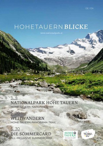
NATIONALPARK HOHE TAUERN NATIONALPARK HOHE TAUERN
Als bereits im Jahr 1872 der weltweit erste Nationalpark – der Yellowstone Nationalpark im Norden der Vereinigten Staaten errichtet wurde – ahnte wohl noch niemand, dass dies der Grundstein für tausende weitere Nationalparks in der ganzen der Welt sein
4 würde, so auch für den Nationalpark Hohe Tauern. Im Jahr 1913 ergriff der Landtags- abgeordnete Dr. August Prinzinger die Ini- tiative und der Verein Naturschutzpark kauf- te rund 1100 ha Grund im Amertal und im Stubachtal an, um es speziell zu schützen.
1971 beschlossen dann die drei Landes- hauptleute von Salzburg, Kärnten und Tirol durch die Unterzeichnung der Dreiländer- Vereinbarung in Heiligenblut die Errich- tung eines Nationalparks. Die Umsetzung dauerte unterschiedlich lange in den einzelnen Ländern und mehrere Etappen galt es zu überwinden. In den 1980er Jahren wurde der Nationalpark Hohe Tauern als erster und größter Nationalpark in Österreich errichtet und seither wurde stets an diesem Projekt weitergearbeitet.
When the world’s first national park – Yel- lowstone National Park, in the northwest- ern United States – was established back in 1872, nobody would ever have imagined it would be the foundation stone for thou- sands of other national parks around the globe, National Park Hohe Tauern amongst them. In 1913, provincial legislator Dr. Au- gust Prinzinger took the initiative and fol- lowing the Nature Sanctuary Association bought up roughly 1100 ha in Amertal and Stubachtal in order to put that land under special protection.
In 1971, the three provincial governors of Salzburg, Carinthia and Tyrol signed the Three Provinces Agreement in Heiligen- blut, thereby committing themselves to creating a national park. The actual im- plementation period varied in length f rom province to province and took place in several stages. In the 1980s, National Park Hohe Tauern finally opened, Austria’s first and largest national park, since when this project has continued to evolve.
HOHETAUERNBLICKE
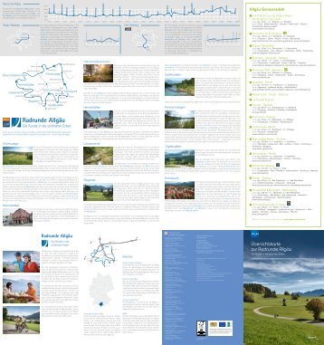
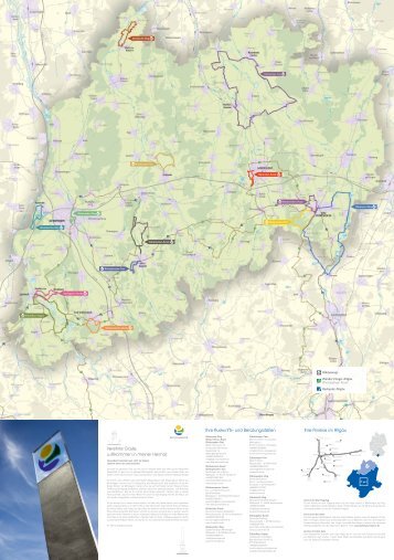
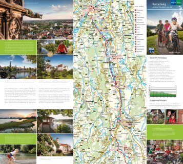
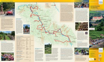
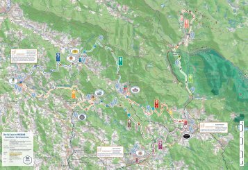
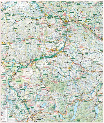
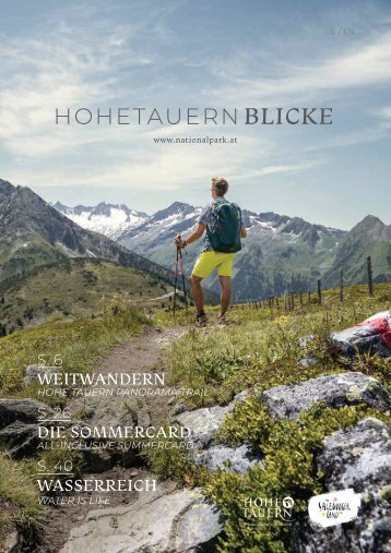
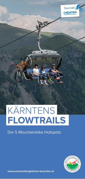
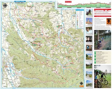
HOHETAUERNBLICKE WEITWANDERN Der „HoheTauern Panorama Trail“ führt auf 270 Kilometern quer durch die Nationalparkregion. Ab Sommer 2022 ist der "HoheTauern Panorama Trail" ein Weitwander-Erlebnis der Extraklasse in der Ferienregion Nationalpark HoheTauern. Im Rahmen von 17 Tagesetappen legen Wanderer vom Startpunkt am Fuße der Krimmler Wasserfälle bis ins Tal der Almen nach Hüttschlag im Großarltal 270 Kilometer und 14.000 Höhenmeter zurück. Übernachtet wird wechselweise im Tal oder auf den Bergen. Der Trail führt quer durch die Nationalparkregion HoheTauern und eröffnet atemberaubende Ausblicke auf die höchsten Berge Österreichs. Die Nutzung von Bergbahnen oder praktischen Shuttle-Diensten an den Etappenzielen sowie ein buchbarer Gepäcktransfer bieten höchsten Komfort. Auf dem Weg liegen Naturschauspiele, sehenswerte Ausstellungen, gepflegte Nationalpark-Orte und attraktive Ausflugsziele. Ein Wander-Erlebnis, das nachhaltig Eindruck hinterlässt Im größten Naturschutzgebiet Zentraleuropas gilt es ein fantastisches Stückchen Erde zu entdecken, das in seiner Vielfalt und Unberührtheit seinesgleichen sucht und in dem die bewegte Geschichte allgegenwärtig ist. Diese Region zu Fuß, aus eigener Kraft und mit kleinem ökologischen Fußabdruck zu entdecken, ist ein Natur- und Wandererlebnis der besonderen Art. Der „HoheTauern Panorama Trail“ macht genau das möglich. Bestens beschildert führt er vom Die größten Wasserfälle Europas, uralte Gletscher und sagenumwobene Handelswege. Bartgeier, Murmeltiere und Gämsen, die Historie des Goldabbaus und ein einzigartiges Smaragdvorkommen. Die mächtigsten Berge Österreichs, Klammen, echte Urwälder und ein international anerkanntes Wildnisgebiet: Die Natur spielt im Nationalpark HoheTauern alle Stücke und ein Superlativ reiht sich an das nächste. Doch auch von Menschenhand Geschaffenes liegt auf dem „HoheTauern Panorama Trail“ und macht diesen nicht nur aufregend schön, sondern auch aufregend spannend und informativ: malerische Orte, seit Generationen bewirtschaftete Almhütten, weltberühmte Orte der Sommerfrische, Wallfahrtsstätten und steinerne Zeitzeugen der Geschichte sowie spektakuläre Ausflugsziele zählen dazu. westlichsten Teil des Bundeslandes Salzburg auf der nördlichen Seite des Salzachtals bis nach Zell am See und von dort immer weiter ostwärts über Raurisertal und Gasteinertal bis ins Großarltal. Die gesamte Strecke von 270 Kilometern ist für 17 Etappen ausgelegt. Pro Tag sind Weitwanderer zwischen vier bis acht Gehstunden – ohne Seilversicherung und in einer Aussichtslage zwischen 1.500 bis 2.400 Meter Seehöhe – unterwegs. Sollten in den Nebensaisonen witterungsbedingt – etwa durch Schnee in den Höhenlagen – die Hauptrouten noch nicht begangen werden können, stehen Wanderern Alternativrouten zur Verfügung. www.hohetauerntrail.at The 270-kilometre HoheTauern Panorama Trail takes you right through the National Park region. From summer 2022, the HoheTauern Panorama Trail in the HoheTauern National Park holiday region will be a long-distance hiking experience that's in a class of its own. Over the course of 17 one-day stages, hikers cover a distance of 270 kilometres and 14,000 metres altitude from the starting point at the foot of the Krimmler Waterfalls to Hüttschlag in the Großarltal valley, also called the "Tal der Almen", or the valley of the Alpine inns. Overnight accommodation alternates between the valley and the mountains. The trail takes hikers through the HoheTauern National Park region, affording breathtaking views of Austria's highest mountains. The mountain railways and handy shuttle services at the stage destinations as well as optional luggage transfer offer maximum comfort. En route you will find stunning natural attractions, great exhibitions, well-kept national parks and attractive excursion destinations. The highest waterfalls in Europe, ancient glaciers and legendary trade routes. Bearded vultures, marmots and chamois, the history of gold mining and unique emerald deposits. Austria's mightiest mountains, ravines, truly primeval forests and an internationally recognised wilderness reserve: At the HoheTauern National Park, nature rolls out one superlative after another. But the picturesque HoheTauern Panorama Trail also offers plenty of exciting and informative man-made wonders: charming towns and villages, Alpine farms passed down through the generations, world-famous summer resorts, places of pilgrimage, stony witnesses to history as well as spectacular tourist destinations. A hiking experience that leaves a lasting impression The largest nature reserve in Central Europe is a stunning part of the world that is more diverse and pristine that almost anywhere else - a place with a chequered history that's all around you. Discovering this region on foot, under your own steam and with a small ecological footprint is a fabulous nature and hiking experience. That's what the HoheTauern Panorama Trail is all about. The trail is well signposted and takes you from the westernmost tip of the province of Salzburg on the northern side of the Salzachtal valley to Zell am See and from there eastwards via the Raurisertal and Gasteinertal valleys and all the way to the Großarltal valley. The 270-kilometre route is perfect for 17 stages. Each day the long-distance hikers walk for four to eight hours – without rope and between 1,500 and 2,400 metres above sea level, affording panoramic views. Alternative routes are available if the main routes cannot be accessed during low season due to bad weather, such as snow at high altitudes. www.hohetauerntrail.at HOHETAUERNBLICKE 9 WEITWANDERN