- Page 1 and 2: Create account or Sign in Loriga |
- Page 3 and 4: Loriga is a town in Portugal locate
- Page 5 and 6: [Lusitanian Warriors. Loriga prides
- Page 7: LORICA - LUSITANIA --- LORIGA - POR
- Page 12 and 13: [Pormenor noturno do centro histór
- Page 14 and 15: A vila está dotada de uma ampla ga
- Page 16 and 17: Lorica, e deste nome derivou Loriga
- Page 18 and 19: [Vestígios medievais de uma casa s
- Page 20: [Um fontanário exibindo uma data d
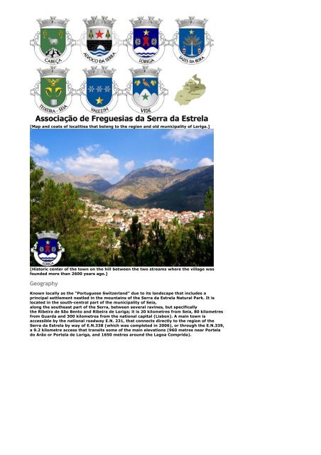
- Page 24: [Mapas e brasões das freguesias at
- Page 27 and 28: A paróquia e a Igreja Matriz de Lo
- Page 29: A igreja tinha três naves e as dim
- Page 32 and 33: substituir o nome latino Lorica que
- Page 34 and 35: [Extratos da obra do historiador An
- Page 36 and 37: [O antigo brasão de Loriga era con
- Page 38 and 39: A vila de Loriga vestida de branco
- Page 40 and 41: Outros sites sobre Loriga / Others
- Page 42 and 43: Freguesias da Região de Loriga [á
- Page 44 and 45: Sazes da Beira Sazes da Beira é um
- Page 46: possuem várias inscrições rupest
- Page 51 and 52: LORIGA Loriga is an ancient, beauti
- Page 53 and 54: Lusitanian Warriors. Loriga prides
- Page 55 and 56: The so-called industrial revolution
- Page 57 and 58: Sepultura antropomórfica com mais
- Page 59 and 60:
Soldado legionário romano usando a
- Page 61 and 62:
ser incluídas plenamente no concel
- Page 63 and 64:
aprenderam com os erros, como se co
- Page 65 and 66:
Loriga ancient Lorica Concise note
- Page 67 and 68:
Brasão de Loriga - Coat of arms He
- Page 69 and 70:
O centro histórico da vila, na col
- Page 71 and 72:
Casa de Repouso Nossa Senhora da Gu
- Page 73 and 74:
Esta prestigiada associação foi f
- Page 75 and 76:
Esta foi a primeira associação lo
- Page 77 and 78:
Mapa da Região e antigo Município
- Page 79 and 80:
Brasão de Teixeira Teixeira Teixei
- Page 81 and 82:
___________________________________
- Page 83 and 84:
vila). Loriga, existe há mais de v
- Page 85 and 86:
Vista do centro histórico de Lorig
- Page 87 and 88:
Terceira Idade, o Grupo Desportivo
- Page 89 and 90:
CASTRUM EST). É um caso raro de um
- Page 91 and 92:
Centro histórico de Loriga com as
- Page 93 and 94:
HOMENAGEM: O Sr.Conde, de uma forma
- Page 95 and 96:
Se o concelho de Loriga não for re
- Page 97 and 98:
Loriga, repairing of EN 231, constr
- Page 99 and 100:
PDF - Extratos da obra do historiad
- Page 101 and 102:
QUANDO O CONCELHO DE LORIGA FOI EXT
- Page 103 and 104:
-----------------------------------
- Page 105 and 106:
Loriga's Site - LINKS Outros sites
- Page 108:
Extratos da obra do historiador Ant
- Page 112:
Extratos da obra do historiador Ant
- Page 143 and 144:
Adelino Manuel Martins de Pina (na
- Page 145 and 146:
Estes são dois dos muitos document
- Page 147 and 148:
478 !"#$%&"#'()%*%+(",-%.%/"#'0("-
- Page 149 and 150:
3782"57733773%588158"8195882587573-
- Page 151 and 152:
!"# 86 845556 257 856584 1234567857
- Page 153 and 154:
0123457089353570123571285070323589
- Page 155:
*+,-,./ 862856249012682227465942785
- Page 158 and 159:
33763'334>3764" &66737945376&79"165
- Page 160 and 161:
DEFGFHIJKLMEJN 76232:3555545+4625+4
- Page 162 and 163:
813334591 0123456898818982310123598
- Page 164 and 165:
593453459&43#33843%98744393534 2994
- Page 166:
123567897676399896766699963769899 6
- Page 170:
12343578935753597753533777577539733
- Page 173 and 174:
023456783934933489483 +' (((')*)(*)
- Page 175:
64219846147484#3488996498444-498139
- Page 178 and 179:
554797753587405748983757! 012034314
- Page 180 and 181:
123456478 6 756 7 8475675 47 7 7 84
- Page 182 and 183:
95649999497964649497497844 12456789
- Page 184 and 185:
02345678935273656759 808008008800 7
- Page 186 and 187:
01234557285549384370283557285941243
- Page 188 and 189:
01234256759723692163712797634661634
- Page 190 and 191:
012346173891 6+0 K38L3891 0B;7:+8,D
- Page 192:
01223457892294293042942125194242149
- Page 197:
!"#0$%&'()0$*+&' 438911231478875594
- Page 202 and 203:
A BC!"!"# 7892629(2(.+&.92+89(63%62
- Page 205 and 206:
! "#$% & '( !& )%( 1*65*6866**+6,-.
- Page 208 and 209:
HIJ *976'53"5,:1545"459".'1*9;2329"
- Page 210 and 211:
.KL9MN(1(OPLLN(QP(R9L9NOK *6&7#/(89
- Page 212 and 213:
&'()*+,-,&./)0+1)+,-,&'()2+,-,3'(0.
- Page 214 and 215:
0123567891369353962383 012356789133
- Page 216 and 217:
012356789131393115362308513 77 7!"!
- Page 218 and 219:
012325673289273829132 0123286732891
- Page 220:
02345678349637353738346 02667834933
- Page 226 and 227:
75 !"#$0%&'()*0%+,'( -./0123045260
- Page 228 and 229:
-,$%./-, %(", :!";
- Page 231 and 232:
1718 2199!179191"!11!9319219117#711
- Page 233 and 234:
[Loriga coat of arms and logos.] Hi
- Page 235 and 236:
Country - Portugal Region - Centro,
- Page 237 and 238:
[Roman legionary soldier wearing Lo
- Page 239 and 240:
[Map and coats of localities that b
- Page 242 and 243:
40º 19 N 7º 41’O * Gentílico -
- Page 244 and 245:
[A bela e sempre premiada praia flu
- Page 246 and 247:
[Guerreiros Lusitanos. Loriga orgul
- Page 248 and 249:
[Troço da estrada romana, na área
- Page 250 and 251:
Loriga era uma paróquia criada pel
- Page 254 and 255:
[Algumas das antigas instalações
- Page 257 and 258:
[Os três monumentais fontanários
- Page 259 and 260:
povoação então existente, e quan
- Page 262 and 263:
[Centro histórico da vila, na coli
- Page 264 and 265:
[A ponte romana ainda existente sob
- Page 266 and 267:
[Brasão de Loriga - Coat of arms.]
- Page 268 and 269:
autoridades competentes. O brasão
- Page 270 and 271:
Vale glaciar de Loriga Praia Fluvia
- Page 272 and 273:
História de Loriga História de Lo
- Page 274 and 275:
Associação de Freguesias da Serra
- Page 276 and 277:
Valezim Valezim é uma freguesia po
- Page 281 and 282:
[Limites aproximados do antigo muni
- Page 286 and 287:
LORIGA - INSTITUIÇÕES E ASSOCIAÇ
- Page 288:
Centro de Assistência Paroquial de
- Page 291:
ecolhendo dados e documentos precio
- Page 294 and 295:
Heráldica Loriguense Resumo do sig
- Page 296 and 297:
(Página do livro manuscrito Histó
- Page 298 and 299:
Região de Loriga - Serra da Estrel
- Page 300 and 301:
Lorica - Lusitania & Loriga - Portu
- Page 302 and 303:
Vila de Loriga, Serra da Estrela -
- Page 304 and 305:
Região de Loriga - Serra da Estrel
- Page 310 and 311:
Powered by Wikidot.com Help | Terms
- Page 312 and 313:
Loriga's Site - LINKS História de
- Page 314:
History of Loriga / História de Lo
- Page 317 and 318:
Create account or Sign in Loriga |
- Page 319 and 320:
Loriga is a town in Portugal locate
- Page 321 and 322:
[Lusitanian Warriors. Loriga prides
- Page 323 and 324:
LORICA - LUSITANIA --- LORIGA - POR
- Page 325:
The region is carved by U-shaped gl
- Page 328 and 329:
[Pormenor noturno do centro histór
- Page 330 and 331:
A vila está dotada de uma ampla ga
- Page 332 and 333:
Lorica, e deste nome derivou Loriga
- Page 334 and 335:
[Vestígios medievais de uma casa s
- Page 336:
[Um fontanário exibindo uma data d
- Page 340:
[Mapas e brasões das freguesias at
- Page 343 and 344:
A paróquia e a Igreja Matriz de Lo
- Page 345:
A igreja tinha três naves e as dim
- Page 348 and 349:
substituir o nome latino Lorica que
- Page 350 and 351:
[Extratos da obra do historiador An
- Page 352 and 353:
[O antigo brasão de Loriga era con
- Page 354 and 355:
A vila de Loriga vestida de branco
- Page 356 and 357:
Outros sites sobre Loriga / Others
- Page 358 and 359:
Freguesias da Região de Loriga [á
- Page 360 and 361:
Sazes da Beira Sazes da Beira é um
- Page 362:
possuem várias inscrições rupest
- Page 367:
Create account or Sign in Loriga |
- Page 372 and 373:
Banda de Loriga em 1905 Sociedade R
- Page 375 and 376:
Emblema da ANALOR e página do jorn
- Page 378 and 379:
Bandeira do CLBP Centro Loriguense
- Page 380 and 381:
(Nota: Esta heráldica foi desenhad
- Page 382 and 383:
strategist to military and diplomat
- Page 384 and 385:
Vila de Loriga Vila de Loriga, Serr
- Page 386 and 387:
Vila de Loriga - Missa transmitida
- Page 388 and 389:
Praia uvial da vila de Loriga Praia
- Page 390:
* More information about the town o
- Page 396 and 397:
Create account or Sign in Loriga |
- Page 398 and 399:
História de Loriga História de Lo
- Page 401 and 402:
Powered by Wikidot.com Help | Terms
- Page 404:
: História concisa da vila de Lori
- Page 408:
A estrada romana ligava Lorica a Eg
- Page 412:
Coroa. No século XII, o concelho d
- Page 416:
vila, os quais até à década de t
- Page 420:
transversais, a que ligava Conímbr
- Page 424:
Loriga@site2002 Casa da Ponte do Ar
- Page 427 and 428:
esconder uma história milenar. Em
- Page 431 and 432:
A Igreja Matriz de Loriga Uma image
- Page 433 and 434:
"adaptação linguística" que tend
- Page 435 and 436:
sublinhar que os estragos não se l
- Page 437 and 438:
Loriga Origem: Wikipédia, a encicl
- Page 439 and 440:
A área que englobava o extinto mun
- Page 441 and 442:
Loriga Origem: Wikipédia, a encicl
- Page 443 and 444:
Loriga e a sua região possuem enor
- Page 445 and 446:
Loriga Origem: Wikipédia, a encicl
- Page 447 and 448:
Loriga e a sua região possuem enor
- Page 449 and 450:
Loriga Origem: Wikipédia, a encicl
- Page 451 and 452:
Crêse que o nome veio da localiz
- Page 453 and 454:
situada na área, no local onde hoj
- Page 455 and 456:
php/ambiente/item/120praiadel
- Page 457 and 458:
Nª. Srª. da Guia, uma das última
- Page 459 and 460:
Marquês de Pombal esteve em Loriga
- Page 461 and 462:
freguesia o tal "brasão" que foi c
- Page 463 and 464:
Loriga Origem: Wikipédia, a encicl
- Page 465 and 466:
Crêse que o nome veio da localiz
- Page 467 and 468:
para depois a reconstruirem com o a
- Page 469 and 470:
Categorias: Freguesias de Seia Anti
- Page 471 and 472:
Nª. Srª. da Guia, uma das última
- Page 473 and 474:
Marquês de Pombal esteve em Loriga
- Page 475 and 476:
incompreensível cumplicidade da Wi
- Page 477 and 478:
Loriga Origem: Wikipédia, a encicl
- Page 479 and 480:
Loriga e a sua região possuem enor
- Page 481:
: Foral Manuelino de Loriga A Hist
- Page 485:
A Lorica usada pelos romanos e que
- Page 489:
sobrevivência, tais como água e s
- Page 493:
Cabeça, Teixeira e Vide. Na primei
- Page 497:
época em que não existia democrac
- Page 501:
outra, construída sobre a Ribeira
- Page 505 and 506:
A Igreja Matriz de Loriga Uma image
- Page 507 and 508:
"adaptação linguística" que tend
- Page 509 and 510:
sublinhar que os estragos não se l
- Page 511 and 512:
Loriga Origem: Wikipédia, a encicl
- Page 513 and 514:
A área que englobava o extinto mun
- Page 515 and 516:
Loriga Origem: Wikipédia, a encicl
- Page 517 and 518:
Loriga e a sua região possuem enor
- Page 519 and 520:
Loriga Origem: Wikipédia, a encicl
- Page 521 and 522:
Loriga e a sua região possuem enor
- Page 523 and 524:
Loriga Origem: Wikipédia, a encicl
- Page 525 and 526:
Crêse que o nome veio da localiz
- Page 527 and 528:
situada na área, no local onde hoj
- Page 529 and 530:
php/ambiente/item/120praiadel
- Page 531 and 532:
Nª. Srª. da Guia, uma das última
- Page 533 and 534:
Marquês de Pombal esteve em Loriga
- Page 535 and 536:
freguesia o tal "brasão" que foi c
- Page 537 and 538:
Loriga Origem: Wikipédia, a encicl
- Page 539 and 540:
Crêse que o nome veio da localiz
- Page 541 and 542:
para depois a reconstruirem com o a
- Page 543 and 544:
Categorias: Freguesias de Seia Anti
- Page 545 and 546:
Nª. Srª. da Guia, uma das última
- Page 547 and 548:
Marquês de Pombal esteve em Loriga
- Page 549 and 550:
incompreensível cumplicidade da Wi
- Page 551 and 552:
Loriga Origem: Wikipédia, a encicl
- Page 553 and 554:
Loriga e a sua região possuem enor
- Page 555:
Loriga vila de Portugal Portuga e p
- Page 558 and 559:
Historia De Loriga - Gentes de Lori
- Page 560 and 561:
Historia De Loriga - Gentes de Lori
- Page 562 and 563:
História resumida de Loriga Detalh
- Page 564 and 565:
sendo de grande importância histó
- Page 566 and 567:
O bairro de São Ginês (São Gens)
- Page 568 and 569:
___________________________________
- Page 570 and 571:
Alvoco da Serra é uma freguesia po
- Page 572 and 573:
deu nome à area e à ribeira mas e
- Page 574 and 575:
LORIGA -PORTUGAL Loriga is an ancie
- Page 576 and 577:
Loriga (Portuguese pronunciation: [
- Page 578:
Por António Conde - Loriga. Extrat
- Page 604 and 605:
esconder uma história milenar. Em
- Page 606:
- 1 - Fontão de Loriga A mais bela
- Page 616 and 617:
933886555!79-25!5 63236563 /0'55793
- Page 618 and 619:
!&"9;;9!# +* +=*A)=,B&>)/) +%!"!>6
- Page 620 and 621:
\89348528981548 0123457893485815482
- Page 622 and 623:
hrh \946'7945689c848(95675(66936434
- Page 624 and 625:
0123456729161621922176 176727172347
- Page 626 and 627:
012345168909199 0123451689844859 e
- Page 628 and 629:
12345674893499239439343242644923948
- Page 630 and 631:
2345679734747435 2493494@49734A4 3
- Page 632 and 633:
.,-
- Page 635 and 636:
2/-:30)-;4/)A90)0+,0)2/-:30)@4/1290
- Page 637 and 638:
./0.123.02450647893.:24784;
- Page 639 and 640:
123242567896287183846872 #$%#&'( *
- Page 641 and 642:
'C1! B1?!T$ Y1!C Q"! > >1''!?""' U
- Page 643 and 644:
3456789558656849 3 1111111111111111
- Page 645 and 646:
BCCCCCCCCCCCCCCCCCCCCCCCCCCCCCCCCCC
- Page 647 and 648:
72523&(+55$7 7252354727457854962 70
- Page 649 and 650:
$365282356282(646%9#46#5868225686 /
- Page 651 and 652:
#$ .,E-?!)!) &#B*!: 3C1 2C'2 11 !2
- Page 653 and 654:
^_`abcde_fg^hf`_bfidj_kblmn_fo_pkcf
- Page 655 and 656:
12345674389 #!776" #!$ "#$ #$ "%&#!
- Page 657 and 658:
o4ž.Ÿ 9(k¡.¢ .(.k£¡(¢.F £4/
- Page 659 and 660:
, 012345628953234161231185282181832
- Page 661 and 662:
*1234)+,4-.,/0,1)+,241)+/-2 438 123
- Page 663 and 664:
12345668648965963694633386484835935
- Page 665:
#$%&%'()*+,($ -77 34678974744778797
- Page 668:
:: 1234567899246235946963366936 123
- Page 688 and 689:
01234167189114218991911229184891128
- Page 690:
13456785948589555457845598554559489
- Page 716 and 717:
Extratos da obra do historiador Ant
- Page 718 and 719:
História da vila de Loriga _ Histo
- Page 720 and 721:
LORIGA - PORTUGAL Extratos da obra
- Page 722 and 723:
Loriga - Das origens à extinção
- Page 724 and 725:
Loriga - Das origens à extinção
- Page 726 and 727:
Loriga - Das origens à extinção
- Page 728 and 729:
Loriga - Das origens à extinção
- Page 730 and 731:
PDF - LORIGA - Vila de PORTUGAL - E
- Page 732 and 733:
PDF - LORIGA - Vila de PORTUGAL - E
- Page 734 and 735:
PDF - LORIGA - Vila de PORTUGAL - E
- Page 736 and 737:
PDF - LORIGA - Denúncia contra a e
- Page 738 and 739:
———————————
- Page 740 and 741:
Extratos da obra de António Conde,
- Page 742 and 743:
LORIGA - Vídeo II LORIGA - Turismo
- Page 744 and 745:
LORIGA - Vila bela e histórica! LA
- Page 746 and 747:
Loriga - Wikipédia - Artigo criado
- Page 748 and 749:
Os melhores sites sobre a terra-nat
- Page 750 and 751:
history of the town of Loriga - Fro
- Page 752 and 753:
PDF - LORIGA - Vila de PORTUGAL - E
- Page 754 and 755:
PDF - LORIGA - Vila de PORTUGAL - E
- Page 756 and 757:
PDF - LORIGA - Vila de PORTUGAL - E
- Page 758 and 759:
PDF - LORIGA - Vila de PORTUGAL - E
- Page 760 and 761:
PDF - LORIGA - Vila de PORTUGAL - E
- Page 762 and 763:
PDF - LORIGA - Vila de PORTUGAL - A
- Page 764 and 765:
PDF - LORIGA - Vila de PORTUGAL - E
- Page 766 and 767:
PDF - LORIGA - Denúncia contra a e
- Page 768 and 769:
Land of Viriathus LORIGA - PORTUGAL
- Page 770 and 771:
LORIGA - SERRA DA ESTRELA LORIGA -
- Page 772 and 773:
LORIGA LORIGA - PORTUGAL Ligações
- Page 774 and 775:
Extratos da obra do historiador Ant
- Page 776 and 777:
Extratos da obra do historiador Ant
- Page 778 and 779:
LORIGA - PORTUGAL LORIGA - VILA DE
- Page 780 and 781:
PDF - LORIGA - Vila de PORTUGAL - E
- Page 782 and 783:
PDF - LORIGA - Vila de PORTUGAL - E
- Page 784 and 785:
PDF - LORIGA - Vila de PORTUGAL - E
- Page 786 and 787:
PDF - LORIGA - Vila de PORTUGAL - E
- Page 788 and 789:
Loriga - Das origens à extinção
- Page 790 and 791:
Loriga - Das origens à extinção
- Page 792 and 793:
Das origens à extinção do munic
- Page 794 and 795:
Das origens à extinção do munic
- Page 796 and 797:
Os melhores vídeos sobre a terra-n
- Page 798 and 799:
Extratos da obra do historiador Ant
- Page 800 and 801:
LORIGA - Land of VIRIATHUS LORIGA -
- Page 802 and 803:
TRIBOS E ANTIGOS POVOS DA LUSITÂNI
- Page 804 and 805:
History of Portugal on the Encyclop
- Page 806 and 807:
478 !"#$%&"#'()%*%+(",-%.%/"#'0("-
- Page 808 and 809:
#124V 32539833581581525953578123258
- Page 810 and 811:
0123456 =1>>?@ABC@2 98924MM9H1#8$89
- Page 812 and 813:
!"#$%&'( 368638C3634E37933837967363
- Page 814 and 815:
#184
- Page 816 and 817:
12456758595597777676767578777745757
- Page 818 and 819:
756 487 12345546578 367 1 7 *735 4
- Page 820 and 821:
12345478938783488839894344497843858
- Page 822 and 823:
33155315357345235235152151757542755
- Page 826 and 827:
?9753 3 67 768 37 78 67 3 38 676 7
- Page 828 and 829:
123567389853956936939963363 3663 &9
- Page 830 and 831:
955827407-4$%14514$'573794444277$%1
- Page 832 and 833:
1234567956747434563636743747779 347
- Page 834 and 835:
96243765858286652787694562878262797
- Page 836 and 837:
K#LMN !"# 012345689623636324 $94%68
- Page 838 and 839:
0123457089353570123571285070323589
- Page 840:
0123451689516 012355160123451689516
- Page 843 and 844:
G H"I !"## 04955214412.421M221?N&14
- Page 845 and 846:
0123456 05G3 889*828(08.5*89*8 4988
- Page 849 and 850:
9171:;
- Page 851 and 852:
município" / History of Loriga - E
- Page 853 and 854:
areas. The larger, older and princi
- Page 855 and 856:
minor. Starting at an altitude of 1
- Page 857 and 858:
Lorica, foi o nome dado pelos Roman
- Page 859 and 860:
visigóticas, aproveitada de um ant
- Page 861 and 862:
política, numa época em que não
- Page 863 and 864:
Matriz, tratando-se de uma pequena
- Page 865 and 866:
almas, aqueles que desenvolvem perm
- Page 867 and 868:
Loriga, Valezim e Alvoco, e isso tr
- Page 869 and 870:
contrário, alguns pseudointelectua
- Page 871:
Lusitanians and Lorica by the Roman
- Page 875 and 876:
História de Loriga | History of Lo
- Page 877 and 878:
Loriga Sobre | About Lorica - Lusit
- Page 879 and 880:
expansão. De estilo românico, com
- Page 881 and 882:
vila, ainda existem vestígios bem
- Page 883 and 884:
povoação e a história antiga da
- Page 885 and 886:
Desde a sua fundação, Sazes perte
- Page 887 and 888:
40.3204694; -7.6661528 - location -
- Page 889 and 890:
century. It was one of the few indu
- Page 893 and 894:
História
- Page 896 and 897:
LORIGA LORIGA - PORTUGAL História
- Page 898 and 899:
Coordinates: 40°1913.69N 7°3958.1
- Page 900 and 901:
[Lusitanian Warriors. Loriga prides
- Page 902 and 903:
Loriga was an ecclesiastical parish
- Page 904 and 905:
Guarda and 300 kilometres from the
- Page 906 and 907:
considered since its time an exampl
- Page 908 and 909:
Loriga é um dos maiores afluentes
- Page 910 and 911:
[Guerreiros Lusitanos. Loriga orgul
- Page 912 and 913:
chegada dos romanos e a Rua de Viri
- Page 914 and 915:
Loriga era uma paróquia criada pel
- Page 917 and 918:
[Algumas das antigas instalações
- Page 919 and 920:
A Região de Loriga, área do antig
- Page 921 and 922:
do Povo, coincide exatamente com um
- Page 923 and 924:
A igreja tinha três naves e as dim
- Page 925 and 926:
Depois, aparece novamente em docume
- Page 927 and 928:
VIRIATO “…Sucedeu o pastor Viri
- Page 929 and 930:
Resumo do significado do brasão Br
- Page 931 and 932:
Para saberem mais sobre esta vila b
- Page 933 and 934:
Vale glaciar de Loriga Praia Fluvia
- Page 935 and 936:
Extratos da obra do historiador Ant
- Page 937 and 938:
História da vila de Loriga - Extra
- Page 939 and 940:
history of the town of Loriga - Fro
- Page 942 and 943:
História concisa de Loriga pelo hi
- Page 944 and 945:
Freguesias da Região de Loriga [á
- Page 946 and 947:
Sazes da Beira Sazes da Beira é um
- Page 948:
Vide Vide é uma freguesia portugue
- Page 951 and 952:
History_of_Portugal_old_and_young_a
- Page 953 and 954:
LORIGA - Vila bela e histórica! LA
- Page 955 and 956:
Extratos da obra do historiador Ant
- Page 957 and 958:
História concisa da vila de Loriga
- Page 959 and 960:
Loriga - Vila Lusitana Loriga - Vil
- Page 963 and 964:
História concisa de Loriga pelo hi
- Page 965 and 966:
Loriga - Wikipedia, the free encycl
- Page 967 and 968:
Loriga - Wikipédia - Artigo criado
- Page 969 and 970:
O caso vergonhoso da cidade portugu
- Page 971 and 972:
LORIGA - Vila de PORTUGAL LORICA -
- Page 973 and 974:
Extratos da obra do historiador Ant
- Page 975 and 976:
História concisa da vila de Loriga
- Page 977 and 978:
Loriga - Vila Lusitana Loriga - Vil
- Page 981 and 982:
História concisa de Loriga pelo hi
- Page 983 and 984:
Loriga - Wikipedia, the free encycl
- Page 985 and 986:
Loriga - Wikipédia - Artigo criado
- Page 987 and 988:
COMUNIDADE_LUSÓFONA_CPLP_Desafios_
- Page 989:
História de Loriga - Memória Port
- Page 993:
História de Loriga - Memória Port
- Page 997 and 998:
Dados do mapa ©2017 Google Imagens
- Page 1000 and 1001:
Dados do mapa ©2017 Google Imagens
- Page 1002 and 1003:
História de Loriga - Visitar Portu
- Page 1004 and 1005:
História resumida de Loriga Detalh
- Page 1006 and 1007:
sendo de grande importância histó
- Page 1008 and 1009:
O bairro de São Ginês (São Gens)
- Page 1010 and 1011:
___________________________________
- Page 1012 and 1013:
Alvoco da Serra é uma freguesia po
- Page 1014 and 1015:
deu nome à area e à ribeira mas e
- Page 1016 and 1017:
LORIGA -PORTUGAL Loriga is an ancie
- Page 1018 and 1019:
Loriga (Portuguese pronunciation: [
- Page 1020:
Por António Conde - Loriga. Extrat
- Page 1046 and 1047:
esconder uma história milenar. Em
- Page 1073 and 1074:
A paróquia e a Igreja Matriz da vi
- Page 1075:
foi depois transformada em capela-s
- Page 1081 and 1082:
LORIGA - INSTITUIÇÕES E ASSOCIAÇ
- Page 1083:
Centro de Assistência Paroquial de
- Page 1086:
ecolhendo dados e documentos precio
- Page 1089 and 1090:
Heráldica Loriguense Resumo do sig
- Page 1091 and 1092:
(Página do livro manuscrito Histó
- Page 1093 and 1094:
Região de Loriga - Serra da Estrel
- Page 1095 and 1096:
Lorica - Lusitania & Loriga - Portu
- Page 1097 and 1098:
Vila de Loriga, Serra da Estrela -
- Page 1099 and 1100:
Região de Loriga - Serra da Estrel
- Page 1105 and 1106:
Powered by Wikidot.com Help | Terms
- Page 1107 and 1108:
[Loriga coat of arms and logos.] Hi
- Page 1109 and 1110:
Country - Portugal Region - Centro,
- Page 1111 and 1112:
[Roman legionary soldier wearing Lo
- Page 1113 and 1114:
[Map and coats of localities that b
- Page 1116 and 1117:
40º 19 N 7º 41’O * Gentílico -
- Page 1118 and 1119:
[A bela e sempre premiada praia flu
- Page 1120 and 1121:
[Guerreiros Lusitanos. Loriga orgul
- Page 1122 and 1123:
[Troço da estrada romana, na área
- Page 1124 and 1125:
Loriga era uma paróquia criada pel
- Page 1128 and 1129:
[Algumas das antigas instalações
- Page 1131 and 1132:
[Os três monumentais fontanários
- Page 1133 and 1134:
povoação então existente, e quan
- Page 1136 and 1137:
[Centro histórico da vila, na coli
- Page 1138 and 1139:
[A ponte romana ainda existente sob
- Page 1140 and 1141:
[Brasão de Loriga - Coat of arms.]
- Page 1142 and 1143:
autoridades competentes. O brasão
- Page 1144 and 1145:
Vale glaciar de Loriga Praia Fluvia
- Page 1146 and 1147:
História de Loriga História de Lo
- Page 1148 and 1149:
Associação de Freguesias da Serra
- Page 1150 and 1151:
Valezim Valezim é uma freguesia po
- Page 1155 and 1156:
[Limites aproximados do antigo muni
- Page 1157 and 1158:
Loriga's Site - LINKS História de
- Page 1159:
History of Loriga / História de Lo
- Page 1162 and 1163:
LORIGA - Vila bela e histórica! LA
- Page 1164 and 1165:
Extratos da obra do historiador Ant
- Page 1166 and 1167:
História concisa da vila de Loriga
- Page 1168 and 1169:
Loriga - Vila Lusitana Loriga - Vil
- Page 1172 and 1173:
História concisa de Loriga pelo hi
- Page 1174 and 1175:
Loriga - Wikipedia, the free encycl
- Page 1176 and 1177:
Loriga - Wikipédia - Artigo criado
- Page 1178 and 1179:
O caso vergonhoso da cidade portugu
- Page 1180 and 1181:
LORIGA - Vila de PORTUGAL LORICA -
- Page 1182 and 1183:
Extratos da obra do historiador Ant
- Page 1184 and 1185:
História concisa da vila de Loriga
- Page 1186 and 1187:
Loriga - Vila Lusitana Loriga - Vil
- Page 1190 and 1191:
História concisa de Loriga pelo hi
- Page 1192 and 1193:
Loriga - Wikipedia, the free encycl
- Page 1194 and 1195:
Loriga - Wikipédia - Artigo criado
- Page 1196 and 1197:
COMUNIDADE_LUSÓFONA_CPLP_Desafios_
- Page 1198 and 1199:
LORIGA LORIGA - PORTUGAL Ligações
- Page 1200 and 1201:
Extratos da obra do historiador Ant
- Page 1202 and 1203:
Extratos da obra do historiador Ant
- Page 1204 and 1205:
Os melhores sites sobre a terra-nat
- Page 1206 and 1207:
Extratos da obra do historiador Ant
- Page 1208 and 1209:
PDF - LORIGA - Vila de PORTUGAL - E
- Page 1210 and 1211:
PDF - LORIGA - Vila de PORTUGAL - E
- Page 1212 and 1213:
PDF - LORIGA - Vila de PORTUGAL - E
- Page 1214 and 1215:
PDF - LORIGA - Vila de PORTUGAL - E
- Page 1216 and 1217:
PDF - LORIGA - Vila de PORTUGAL - E
- Page 1218 and 1219:
Loriga - Das origens à extinção
- Page 1220 and 1221:
PDF - LORIGA - Vila de PORTUGAL - E
- Page 1222 and 1223:
PDF - LORIGA - Vila de PORTUGAL - E
- Page 1224 and 1225:
PDF - LORIGA - Vila de PORTUGAL - E
- Page 1226 and 1227:
Os melhores vídeos sobre a terra-n
- Page 1228 and 1229:
Extratos da obra do historiador Ant
- Page 1230 and 1231:
LORIGA - Escola Básica LORIGA - La
- Page 1232 and 1233:
LUSITÂNIA - CRONOLOGIA HISTÓRICA
- Page 1234 and 1235:
History of Portugal on the Encyclop
- Page 1236 and 1237:
LORIGA - Vila bela e histórica! LA
- Page 1238 and 1239:
LORIGA VILA LUSITANA Loriga - Vila
- Page 1240 and 1241:
LORIGA-PORTUGAL História da vila d
- Page 1242 and 1243:
Extratos da obra do historiador Ant
- Page 1244 and 1245:
Extratos da obra do historiador Ant
- Page 1246 and 1247:
PDF - LORIGA - Vila de PORTUGAL - E
- Page 1248 and 1249:
PDF - LORIGA - Vila de PORTUGAL - E
- Page 1250 and 1251:
PDF - LORIGA - Vila de PORTUGAL - E
- Page 1252 and 1253:
PDF - LORIGA - Vila de PORTUGAL - E
- Page 1254 and 1255:
Das origens à extinção do munic
- Page 1256 and 1257:
PDF - LORIGA - Vila de PORTUGAL - E
- Page 1258 and 1259:
PDF - LORIGA - Vila de PORTUGAL - E
- Page 1260 and 1261:
PDF - LORIGA - Vila de PORTUGAL - E
- Page 1262 and 1263:
inseriu na sua referida obra, e out
- Page 1264 and 1265:
PDF - LORIGA - Denúncia contra a e
- Page 1266 and 1267:
———————————
- Page 1268 and 1269:
Extratos da obra do historiador Ant
- Page 1270 and 1271:
LORIGA - Vídeos VI LORIGA - Vídeo
- Page 1272 and 1273:
LORIGA - Vila de PORTUGAL LORICA -
- Page 1274 and 1275:
Extratos da obra História concisa
- Page 1276 and 1277:
LORIGA - PORTUGAL _ LORICA LUSITANO
- Page 1278 and 1279:
LORIGA - PORTUGAL LORIGA - PORTUGAL
- Page 1280 and 1281:
Loriga - Das origens à extinção
- Page 1282 and 1283:
Loriga - Das origens à extinção
- Page 1284 and 1285:
Loriga - Das origens à extinção
- Page 1286 and 1287:
Loriga - Das origens à extinção
- Page 1288 and 1289:
Loriga - Das origens à extinção
- Page 1290 and 1291:
Das origens à extinção do munic
- Page 1292 and 1293:
PDF - LORIGA - Vila de PORTUGAL - E
- Page 1294 and 1295:
PDF - LORIGA - Vila de PORTUGAL - E
- Page 1296 and 1297:
PDF - LORIGA - Vila de PORTUGAL - E
- Page 1298 and 1299:
PDF - LORIGA - Denúncia contra a e
- Page 1300 and 1301:
PDF - LORIGA - Denúncia contra a e
- Page 1302 and 1303:
LORIGA LUSÓFONA LORIGA - PORTUGAL
- Page 1304 and 1305:
LORIGA - Bombeiros LORIGA - Escola
- Page 1306 and 1307:
Curtir Seja o primeiro a curtir est
- Page 1308 and 1309:
+(,"-.+(!"%"&(/$%"0(%" "%,)(*(+(,"-
- Page 1310 and 1311:
35319925529193353913539258129458529
- Page 1312 and 1313:
0123457089353570123571285070323589
- Page 1314 and 1315:
()*+*,- 84084565526&9'5246356543103
- Page 1316 and 1317:
67933763333756 636963474333&69'37&9
- Page 1318 and 1319:
1234356789:27; 18311821157213596683
- Page 1320 and 1321:
12345653489333636536665636396398533
- Page 1322 and 1323:
898458793&88&485#43-3939333"8453473
- Page 1324:
6336679969869786569399379 788978698
- Page 1328 and 1329:
4347475779337934)779397*& 4%35775*3
- Page 1330 and 1331:
023456783934933489483 +' (((')*)(*)
- Page 1332 and 1333:
88270820858171375881587028350718170
- Page 1334 and 1335:
4$#+ !"#$%&!"'%"($#)*+,"-"'!).+$!"
- Page 1336 and 1337:
123456478 6 756 7 8475675 47 7 7 84
- Page 1338 and 1339:
1245678949978449567699497497844646
- Page 1340 and 1341:
7)!%*+ B&)!%* 54,-6&754(!%-&)!%* -0
- Page 1343 and 1344:
01234256759723692163712797634661634
- Page 1345 and 1346:
012346173891 6+0 K38L3891 +;C6+7(J"
- Page 1347:
12343637893632489963339989936368363