Kopalnia Soli w Kłodawie
Kopalnia Soli w Kłodawie
Kopalnia Soli w Kłodawie

You also want an ePaper? Increase the reach of your titles
YUMPU automatically turns print PDFs into web optimized ePapers that Google loves.
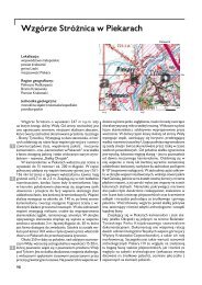
K³odawa<br />
The K³odawa Rock-salt Mine<br />
The K³odawa Mine located in the Wielkopolska District,<br />
close the the A2 state highway, between Poznañ and<br />
Warszawa, exploits the rocks-salt (halite) and the K-Mg<br />
salts from the classic salt dome.<br />
The K³odawa dome belongs to 60-kilometers-long anticlinal<br />
structure extending from Izbica Kujawska to Solca<br />
Wielka villages. This is the largest salt dome in the Polish<br />
Lowlands (24 kilometers long and up to 2 kilometers wide)<br />
composed of Zechstein (Upper Permian) rock-salt. From<br />
the southwest the dome borders the Middle and Upper<br />
Jurassic strata whereas from the northeast it contacts the<br />
Upper Triassic and Lower Jurassic formations. The dome is<br />
covered by transgressive Tertiary and Quaternary sediments<br />
which form the clayey-gypsum cap of variable thickness (from<br />
several up to about 170 meters). The dome includes three<br />
parts: (i) northeastern marginal anticline composed mostly<br />
of the Older Halite, (ii) central anticline with the Youngest<br />
Halite and (iii) southwestern marginal anticline built of transitional<br />
sequence of Oldest and Older Halites.<br />
Mining operations are focused on the Oldest Halite (Z2<br />
stage), Younger Basal Halite (lower part of Z3 stage) and<br />
whitish-pink Youngest Halite (middle Z4 stage). Recently,<br />
small amounts of K-Mg salts are also worked. Depth of current<br />
mining operations is 600-750 meters below surface and<br />
the average NaCl content falls into the range 94-98 wt%.<br />
At the 600-meters level a 2.5-3.0-meters-thick zone<br />
of blue halite was encountered within the lower part of<br />
Younger Halite member. Crystals of blue halite range in size<br />
from several millimeters to about 2 centimeters and show<br />
variable colours – from light-blue to deep blue. Both varities<br />
form random or linear accumulations. Their origin is related<br />
to tectonic shear and displacement zones.<br />
The underground workings can be visited by organized<br />
groups. The underground trail allow to recognize the history<br />
of K³odawa dome, its geology referred to the development<br />
of Zechetin sedimentary basin in Poland, the mining operations<br />
and the industrial applications of rock-salt. Additional<br />
attraction is the unique blue halite zone.<br />
1 2<br />
Przekrój geologiczny wysadu K³odawa<br />
(wg Poborskiego)<br />
1 –czapa solna, 2- brze¿na antyklina<br />
p³n.-wsch. z przewa¿aj¹c¹ starsz¹ sol¹<br />
kamienn¹, 3- œrodkowa synklina z m³odsz¹<br />
sol¹ kamienn¹, 4- brze¿na antyklina p³d.-<br />
zach. z przewa¿aj¹cym pograniczem soli<br />
starszych i najstarszych na odcinku NW<br />
s³abo zbadanym.<br />
Wybrana literatura: 72, 73, 198, 345, 439<br />
Autorzy karty stanowiska dokumentacyjnego i fotografii:<br />
A. Makowska, R. Dobracki (2005)<br />
233