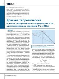
Совзонд - ÐеомаÑика
Совзонд - ÐеомаÑика
Совзонд - ÐеомаÑика

You also want an ePaper? Increase the reach of your titles
YUMPU automatically turns print PDFs into web optimized ePapers that Google loves.
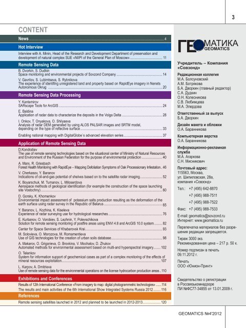
3<br />
Content<br />
News....................................................................................................................................................... 4<br />
Hot Interview<br />
Interview with A. Minin, Head of the Research and Development Department of preservation and<br />
development of natural complex SUE «NIIPI of the General Plan of Moscow».................................... 11<br />
Remote Sensing Data<br />
B. Dvorkin, S. Dudkin<br />
Space monitoring and environmental projects of Sovzond Company.................................................... 14<br />
V. Gavrilov, S. Lubimtseva, S. Rybnikova<br />
The experience of identifing unregistered land and property based on RapidEye imagery in Nenets<br />
Autonomous Okrug ................................................................................................................................ 20<br />
Remote Sensing Data Processing<br />
Y. Kantemirov<br />
SARscape Tools for ArcGIS.................................................................................................................... 24<br />
E. Baldina<br />
Application of radar data to characterize the deposits in the Volga Delta.............................................. 28<br />
I. Onkov, T. Onyakova, O. Shilyaeva<br />
Analysis of radar DEM generated by using ALOS PALSAR images and SRTM model,<br />
depending on the type of reflective surface............................................................................................ 33<br />
Enabling national mapping with DigitalGlobe`s advanced elevation series........................................... 37<br />
Application of Remote Sensing Data<br />
D.Kondratiev<br />
The use of remote sensing technologies based on the situational center of Ministry of Natural Resources<br />
and Environment of the Russian Federation for the purpose of environmental protection........................ 40<br />
A. Marx, R. Griesbach<br />
Forest Health Monitoring with RapidEye – Mapping Defoliation Symptoms of Oak Processionary Infestation. . 46<br />
V. Cherkasov, Y. Baranov<br />
Indications of oil-and-gas potential of shelves based on to the satellite radar imaging......................... 52<br />
K. Boyarschuk, M. Tumanov, L. Miloserdova<br />
Aerospace methods of geological identification (for example the construction of the space launching<br />
site Vostochny)........................................................................................................................................ 60<br />
D. Gorsky, K. Khomenkov<br />
Environmental impact assessment of potassium salts production resulting as the deformation of the<br />
earth surface using radar survey in the Republic of Belarus.................................................................. 65<br />
Y. Baranov, L. Kozhina, K. Kiseleva<br />
Experience of radar surveying use for hydrological researches............................................................. 76<br />
E. Kurbanov, O. Vorobiev, S. Lezhnin, Y. Polevschikova<br />
Solution for remote sensing monitoring of postfire areas using ENVI 4.8 and ArcGIS 10.0 system.......... 82<br />
Center for Space Services of Khabarovsk Krai...................................................................................... 93<br />
M. Solovieva, O. Morozova, M. Romamentieva<br />
Use of GIS technologies for the creation of urban soils database......................................................... 98<br />
A. Makarov, O. Grigorieva, O. Brovkina, V. Mochalov, D. Zhukov<br />
Automated methods for environmental assessment based on multi-and hyperspectral imagery........ 102<br />
O. Telenkov<br />
System for information support of geochemical cases as part of a complex monitoring of the effects of<br />
mineral resources exploitation.............................................................................................................. 107<br />
L. Karpov, A. Dmitrieva<br />
Use of remote sensing data for the environmental operations on the license hydrocarbon production areas... 110<br />
Exhibitions and Conferences<br />
Results of 12th International Conference «From imagery to map: digital photogrammetric technologies»........114<br />
The results and main activities of the 6th International Show Integrated Systems Russia 2012......... 116<br />
References<br />
Remote sensing satellites launched in 2012 and planned to be launched in 2012-2013.................... 120<br />
Учредитель – Компания<br />
«Совзонд»<br />
Редакционная коллегия<br />
М.А. Болсуновский<br />
А.М. Ботрякова<br />
Б.А. Дворкин (главный редактор)<br />
C.А. Дудкин<br />
О.Н. Колесникова<br />
С.В. Любимцева<br />
М.А. Элердова<br />
Ответственный за выпуск<br />
Б.А. Дворкин<br />
Дизайн макета и обложки<br />
О.А. Баранникова<br />
Компьютерная верстка<br />
О.А. Баранникова<br />
Информационнорекламная<br />
служба<br />
М.А. Агаркова<br />
С.Н. Мисникович<br />
Почтовый адрес:<br />
115563, Москва,<br />
ул. Шипиловская, 28а,<br />
компания «Совзонд»<br />
Тел.: +7 (495) 642-8870<br />
+7 (495) 9887511<br />
+7 (495) 9887522<br />
Факс: +7 (495) 9887533<br />
Email: geomatics@sovzond.ru<br />
Интернет: www.geomatica.ru<br />
Перепечатка материалов без разрешения<br />
редакции запрещается.<br />
Тираж 3000 экз.<br />
Рекомендованная цена – 217 р. 50 к.<br />
Номер подписан в печать<br />
09.11.2012 г.<br />
Печать<br />
ООО «Юнион-Принт»<br />
Свидетельство о регистрации<br />
в Россвязькомнадзоре<br />
ПИ №ФС7734855 от 13.01.2009 г.<br />
geomatics №4'2012