- Page 1 and 2: REPÚBLICA DEL PERU PRESIDENCIA DE
- Page 3 and 4: REPÚBLICA DEL PERU PRESIDENCIA DE
- Page 5 and 6: -11 - 6. Otras actividades económi
- Page 7 and 8: ?;g, 492 CUENCAS DE LOS RÍOS SANJT
- Page 9 and 10: Pág„ 494 CUENCAS DE LOS RÍOS SA
- Page 11 and 12: Páq. IQ6 -.^ CAS Dh LOS RÍOS SANT
- Page 13 and 14: Pág, 498 - *S DE LOS RÍOS SANTA,
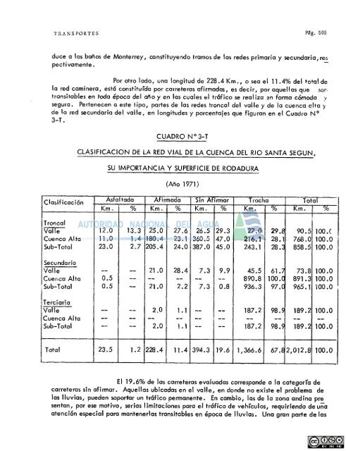
- Page 15 and 16: Pág„ 500 (I)» La Red Vial Tronc
- Page 17 and 18: 502 VENGAS DE LOS RÍOS SANTA, LACB
- Page 19: Pa 3o 504 i.^^CAS DE LOS RÍOS SANT
- Page 23 and 24: Pág. 508 CUENCAS DE LOS RÍOS SANT
- Page 25 and 26: Pág. 510 CUENCAS DE LOS RÍOS SANT
- Page 27 and 28: Pág. 512 CUENCAS DE LOS RÍOS SANT
- Page 29 and 30: Pág, 514 CUENCAS DE LOS RÍOS SANT
- Page 31 and 32: Píg, 516 CUENCAS DE LOS RÍOS SANT
- Page 33 and 34: 18 CHUNCAS DE LOS RÍOS SANTA, LACR
- Page 35 and 36: Pdg. 520 '.nS DE LOS RÍOS SANTA, L
- Page 37 and 38: Pág. 522 SÜ-iT--- . &•< Foto N
- Page 39 and 40: Pág - 524 --'' ^-AS DE LOS RÍOS S
- Page 41 and 42: Pig. 526 CUENCAS DE LOS RÍOS SANTA
- Page 43 and 44: p£a. 528 CUENCAS DE LOS RÍOS SANT
- Page 45 and 46: Pág. 530 CUENCAS DE LOS RÍOS SANT
- Page 47 and 48: Pág. 532 CUENCAS DE LOS RÍOS SANT
- Page 49 and 50: Carretera Número Nombre CUADRO N'
- Page 51 and 52: 5:6 ill v'-AS DE LOM RÍOS SANTA, L
- Page 53 and 54: Pág. 538 CUENCAS DE LOS RÍOS SANT
- Page 55 and 56: Pág ' 540 - ^ NCAS DE LOS RÍOS SA
- Page 57 and 58: 542 CUENCAS DE LOS RÍOS SANTA, LAC
- Page 59 and 60: Pig. 544 CUENCAS DE LOS RÍOS SANTA
- Page 61 and 62: Pág. 546 CUENCAS DE LOS RÍOS SANT
- Page 63 and 64: Pág. 548 CUENCAS DE LOS RÍOS SANT
- Page 65 and 66: Pi ;. 550 CUENCAS DE LOS MOS SANTA,
- Page 67 and 68: ) Número CARRETERAS NACIONALES CUA
- Page 69 and 70: Pág. 554 CUENCAS DE LOS RÍOS SANI
- Page 71 and 72:
p ág. 556 CUENCAS DE LOS RÍOS SAN
- Page 73 and 74:
558 CUENCAS DE LOS RÍOS SANTA, LAC
- Page 75 and 76:
Pág. 560 CUENCAS DE LOS RÍOS SANT
- Page 77 and 78:
Piga 562 CUENCAS DE LOS RÍOS SANTA
- Page 79 and 80:
CUENCAS DE LOS RÍOS SANTA, LACRAMA
- Page 81 and 82:
, 566 CUENCAS DE LOS RÍOS SANTA, L
- Page 83 and 84:
Pág, 568 CUENCAS DE LOS RÍOS SANT
- Page 85 and 86:
"ág, 570 CUENCAS DE LOS RÍOS SANT
- Page 87 and 88:
Clasificación Troncal Valle Cuenca
- Page 89 and 90:
Número 12-00IN 02-104 02-102 02-51
- Page 91 and 92:
Pág, 576 L'JiZKCAS DE LOS RÍOS SA
- Page 93 and 94:
p.-;,^ 578 CUENCAS DE LOS RÍOS SAN
- Page 95 and 96:
Pdg. 580 CUENCAS DE LOS RÍOS SANTA
- Page 97 and 98:
Pág. 582 Foto N° 29 Vista del Mue
- Page 99 and 100:
Pág, 584 CUENCAS DE LOS RÍOS SANT
- Page 101 and 102:
Pág. 586 CUENCAS DE LOS RÍOS SANT
- Page 103 and 104:
Pig. cc $8 C hMCAS DE LOS RIOS SANT
- Page 105 and 106:
Pig, 590 CUENCAS DE LOS RJOS SANTA,
- Page 107 and 108:
Exportación Muelles 1 y 2 Harina d
- Page 109 and 110:
Pag, ^94 • JCAS Dt LOS RÍOS SANT
- Page 111 and 112:
Pág„ ñ96 >- LÜCAS DE LOS RÍOS
- Page 113 and 114:
CUENC \S DE LOS laOS S,\NTA, LACR^M
- Page 115 and 116:
Pág. 600 CUENCAS DE LOS RÍOS SANT
- Page 117 and 118:
Pág. 602 CUENCAS DE LOS RÍOS SANT
- Page 119 and 120:
Pág. 604 CUENCAS DE LOS RÍOS SANT
- Page 121 and 122:
Pág. 606 CUENCAS DE LOS RÍOS SANT
- Page 123 and 124:
Pág. 608 CUENCAS DE LOS RÍOS SANT
- Page 125 and 126:
Pág. 610 CUENCAS DE LOS RÍOS SANT
- Page 127 and 128:
Mediana Propiedad Gran Propiedad CU
- Page 129 and 130:
Pág. 614 CUENCAS DE LOS RÍOS SANT
- Page 131 and 132:
CUADRO N 0 6-DA ESTIMACIONES DE COS
- Page 133 and 134:
Pág„ 618 CUENCAS DE LOS REOS SAN
- Page 135 and 136:
Pag, 620 CUENCAS nr luS RÍOS b.ANT
- Page 137 and 138:
Pág. 622 CUENCAS DE LOS RÍOS SANT
- Page 139 and 140:
Pág, 624 mentos de: CUENCAS DE LOS
- Page 141 and 142:
Pig 626 CUENCAS DE LOS RÍOS SANTA,
- Page 143 and 144:
g. 628 CUENCAS DE LOS RÍOS SANTA,
- Page 145 and 146:
Pág. 630 CUENCAS DE LOS RÍOS SANT
- Page 147 and 148:
' CUENCAS DE LOS RÍOS SANTA, LACRA
- Page 149 and 150:
Pag 634 CUENCAS DE LOS RÍOS SANTA,
- Page 151 and 152:
Pág„ 636 CUENCAS DE LOS RÍOS SA
- Page 153 and 154:
Pag, 638 CUENCAS DE LOS RÍOS SANTA
- Page 155 and 156:
Pág, 640 CUENCAS DE LOS RÍOS SANT
- Page 157 and 158:
Pág. 642 CUENCAS DE LOS RÍOS SANT
- Page 159 and 160:
Pág. 644 CUENCAS DE LOS RÍOS SANT
- Page 161 and 162:
Pág„ 646 CUENCAS DE LOS RÍOS SA
- Page 163 and 164:
Pág. 648 CUENCAS DE LOS RÍOS SANT
- Page 165 and 166:
Pag„ 650 CUENCAS DE LOS MOS SANTA
- Page 167 and 168:
CUENCAS DE LOS RÍOS SANTA, LACRAMA
- Page 169 and 170:
Pig, 654 CUENCAS DE LOS RÍOS SANTA
- Page 171 and 172:
Pág„ 656 CUENCAS DE LOS RÍOS SA
- Page 173 and 174:
Pág. 658 CUENCAS DE LOS RÍOS SANT
- Page 175 and 176:
Pág. 660 CUENCAS DE LOS RÍOS SANT
- Page 177 and 178:
62 CUENCAS DE LOS RÍOS SANTA, LACR
- Page 179 and 180:
Pág. 664 CUENCAS DE LOS RÍOS SANT
- Page 181 and 182:
666 CUENCAS DE LOS RÍOS SANTA, LAC
- Page 183 and 184:
Pág„ 668 CUENCAS DE LOS RÍOS SA
- Page 185 and 186:
g. 670 CUENCAS DE LOS RÍOS SANTA,
- Page 187 and 188:
672 CUENCAS DE LO; RJOS SANTA, LACR
- Page 189 and 190:
Pág„ 674 CUENCAS DE LOS RÍOS SA
- Page 191 and 192:
Cultivos Caña de azúcar en crecim
- Page 193 and 194:
Cultivos Caña de azúcar Yuca Mafz
- Page 195 and 196:
CUENCAS DE LOS RÍOS SANTA, LACRAMA
- Page 197 and 198:
Pág, 682 CUENCAS DE LOS RÍOS SANT
- Page 199 and 200:
Pág,, 684 CUENCAS DE IDS RÍOS SAN
- Page 201 and 202:
Pág. 686 CUENCAS DE LOS RÍOS SANT
- Page 203 and 204:
Pag 638 CDENCAS DE LOS RÍOS SANTA,
- Page 205 and 206:
Pás 690 gl CUENCAS DE LOS RÍOS SA
- Page 207 and 208:
Pág„ 692 6. Otras Actividades Ec
- Page 209 and 210:
'ag. 694 CUENCAS DE LOS RÍOS SANTA
- Page 211 and 212:
696 CUENCAS DE LOS RÍOS SANT.i, LA
- Page 213 and 214:
Pág, 698 CUENCAS DE LOS RÍOS SANT
- Page 215 and 216:
700 c. Mercado Principales Centros
- Page 217 and 218:
Pág ° 702 CUENCAS DE LOS RÍOS SA
- Page 219 and 220:
Pág, 704 CUENCAS DE LOS RÍOS SANT
- Page 221 and 222:
Pág. 706 bo Comercialización del
- Page 223 and 224:
Compradores CIRCUITO DE COMERCIALIZ
- Page 225 and 226:
708 CUENCAS DE LOS RÍOS SANTA, LAC
- Page 227 and 228:
Pág. 710 CUENCAS DE LOS RÍOS SANT
- Page 229 and 230:
712 CUENCAS DE LOS RÍOS SANTA, LAC
- Page 231 and 232:
Pág, 714 (1). Oferta d. Comerciali
- Page 233 and 234:
716 CUENCAS DE LOS RÍOS SANTA, LAC
- Page 235 and 236:
Pág„ 718 Piecío al por mayor (s
- Page 237 and 238:
720 CUENCAS DE LOS RÍOS SANTA, LAC
- Page 239 and 240:
Pág. 722 CUENCAS DE LOS RÍOS SANT
- Page 241 and 242:
Pá S* 724 CUENCAS DE LOS RÍOS SAN
- Page 243 and 244:
726 Sistemas de Comercialización C
- Page 245 and 246:
728 £lÍIL£[H£iTj52c^ '" ^£2P!2
- Page 247 and 248:
730 CUENCAS DE LOS RÍOS SANTA» LA
- Page 249 and 250:
732 CUENCAS DE LOS RÍOS SANTA, LAC
- Page 251 and 252:
Pig. 734 (¡). Oferta Cl ase Primer
- Page 253 and 254:
736 CUENCAS DE >LOS RÍOS SANTA, LA
- Page 255 and 256:
Pág, 738 CUENCAS DE LOS RÍOS SANT
- Page 257 and 258:
Pág. 740 CUENCAS DE LOS RÍOS SANT
- Page 259 and 260:
742 CUENCAS DE LOS RÍOS SANTA, LAC
- Page 261 and 262:
Pá g' 744 CUENCAS DE LOS RÍOS SAN
- Page 263 and 264:
Pág. 746 CUENCAS DE LOS RÍOS SANT
- Page 265 and 266:
Nombre del Proyecto 1. Mejoramiento
- Page 267 and 268:
Pág. 750 CUENCAS DE LOS RÍOS SANT
- Page 269 and 270:
Pág. 752 du Recuperación de Tierr
- Page 271 and 272:
Sg. 754 CUENCAS DE LOS RÍOS SANTA,
- Page 273 and 274:
PRIMERA ETAPA Nombre del Proyecto 1
- Page 275 and 276:
Pág. 758 CUENCAS DE LOS RÍOS SANT
- Page 277 and 278:
Pág. 760 CUENCAS DE LOS P^O^ SANTA
- Page 279 and 280:
Pág. 762 Costos Iniciales Descripc
- Page 281 and 282:
Pá g' 764 CUENCAS DE LOS RÍOS SAN
- Page 283 and 284:
Pág. 766 CUENCAS DE LOS Rt,OS SANT
- Page 285 and 286:
Pág. 768 CUENCAS DE LOS PJOS SANTA
- Page 287 and 288:
Pág. 770 CiY^CAS DE LOS kIOS SAN'I
- Page 289 and 290:
Pág, 772 CUENCAS DE LOS KLOO ; ^TA
- Page 291 and 292:
Pág. 774 . ubV Ab DE LOS K ;• ^i
- Page 293 and 294:
Pág. 776 CUADRO N 0 14-PD CUENCAS
- Page 295 and 296:
Pág„ 773 (3)o Industria Procesad
- Page 297 and 298:
Pig, 780 CUENCAS DE LOS RÍOS SANTA
- Page 299 and 300:
Descripción 1. Topografía 2. Clav
- Page 301 and 302:
Pág. 784 CUENCAS DE IJOS PTOS S\NT
- Page 303 and 304:
p^ 786 , r i :lC M, JE LOb BIO-, .A
- Page 305 and 306:
Pág. 788 b„ Segunda prioridad (1
- Page 307 and 308:
Pág, 790 CUENCAS DE LOS ESOS SANTA
- Page 309 and 310:
Pág, 792 A, B. C'JEMCAS DE LOS RÍ
- Page 311 and 312:
Pág. 794 PRIMERA ETAPA Descripció
- Page 313 and 314:
Pág, "96 CUENCAS DE LOS RÍOS SANT
- Page 315 and 316:
Pág„ 798 a. Incremento en la Pro
- Page 317 and 318:
Pág. 800 CUENCAS DE LOS RÍOS SANT
- Page 319 and 320:
h —i Cultt LK Extens>6n i (. ha i
- Page 321 and 322:
Pág. 804 CUENCAS DE LOS RIOs SANTA
- Page 323 and 324:
Pág. 806 CUENCAS DE LOS RIO! SANTA
- Page 325 and 326:
Pág. 808 CUENCAS DE LOS RÍOS SANT
- Page 327 and 328:
Años Sonta Laci-omarca 15,094 40,4
- Page 329 and 330:
z o _l _J s o UJ u O iZ < < I— o
- Page 331 and 332:
Pág„ 814 CUENCAS DE LOS RiüS SA
- Page 333 and 334:
Pág„ 816 CUENCAS DE LOS RÍOS SA
- Page 335 and 336:
Pág, 818 20 Recomendaciones CUENCA
- Page 337 and 338:
RELACIÓN DE ESTUDIOS EFECTUADOS PO