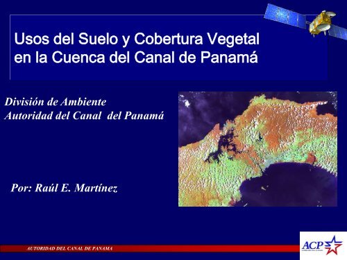
Usos del Suelo y Cobertura Vegetal en la Cuenca del Canal de ...
Usos del Suelo y Cobertura Vegetal en la Cuenca del Canal de ...
Usos del Suelo y Cobertura Vegetal en la Cuenca del Canal de ...

You also want an ePaper? Increase the reach of your titles
YUMPU automatically turns print PDFs into web optimized ePapers that Google loves.
<strong>Usos</strong> <strong><strong>de</strong>l</strong> <strong>Suelo</strong> y <strong>Cobertura</strong> <strong>Vegetal</strong><br />
<strong>en</strong> <strong>la</strong> Cu<strong>en</strong>ca <strong><strong>de</strong>l</strong> <strong>Canal</strong> <strong>de</strong> Panamá<br />
División <strong>de</strong> Ambi<strong>en</strong>te<br />
Autoridad <strong><strong>de</strong>l</strong> <strong>Canal</strong> <strong><strong>de</strong>l</strong> Panamá<br />
Por: Raúl E. Martínez<br />
AUTORIDAD DEL CANAL DE PANAMA
G<strong>en</strong>erar información perman<strong>en</strong>te <strong><strong>de</strong>l</strong> estado<br />
<strong>de</strong> <strong>la</strong> cobertura vegetal y los procesos <strong>de</strong><br />
cambios que se produc<strong>en</strong><br />
Estado g<strong>en</strong>eral <strong>de</strong> <strong>la</strong> cobertura<br />
Fragm<strong>en</strong>tación <strong>de</strong> <strong>la</strong> cobertura Boscosa<br />
Tasa <strong>de</strong> <strong>de</strong>forestación<br />
Cambios ocurridos (dinámica y t<strong>en</strong>d<strong>en</strong>cias)<br />
Mo<strong><strong>de</strong>l</strong>o <strong>de</strong> Cambio<br />
Programa <strong>de</strong> Vigi<strong>la</strong>ncia <strong>de</strong> <strong>la</strong> <strong>Cobertura</strong> <strong>Vegetal</strong><br />
A<br />
NIVEL<br />
DE LA<br />
CUENCA<br />
A<br />
Nivel<br />
Local
Aspectos Metodológicos<br />
Establecimi<strong>en</strong>to <strong>de</strong><br />
parce<strong>la</strong>s <strong>de</strong> muestreo<br />
C<strong>la</strong>sificación <strong>de</strong> imág<strong>en</strong>es<br />
<strong>de</strong> resolución media<br />
C<strong>la</strong>sificación espectral<br />
<strong>Usos</strong> 1986<br />
Deforestación<br />
<strong>Cobertura</strong><br />
AUTORIDAD DEL CANAL DE PANAMA<br />
Bosques maduros<br />
Bosques secundarios<br />
Matorrales<br />
Pastizales<br />
Paja <strong>Canal</strong>era<br />
<strong>Suelo</strong>s sin vegetación<br />
Compi<strong>la</strong>ción<br />
Cartográfica<br />
<strong>Usos</strong> 2003<br />
Sobreposición digital comparativa<br />
Matriz comparativa<br />
C<strong>la</strong>sificación <strong>de</strong> Imág<strong>en</strong>es<br />
<strong>de</strong> alta resolución<br />
Digitalización manual<br />
Cultivos<br />
P<strong>la</strong>ntaciones forestales<br />
Explotación Minera<br />
Pob<strong>la</strong>dos<br />
Dinámica<br />
Fragm<strong>en</strong>tación<br />
T<strong>en</strong>d<strong>en</strong>cias<br />
<strong>Usos</strong> 20085
S<strong>en</strong>sores<br />
1989 1991 2004<br />
AUTORIDAD DEL CANAL DE PANAMA<br />
IMAGENES ASTER<br />
IMAGENES LANDSAT<br />
2008<br />
IMAGENES IKONOS
Resultados<br />
<strong>Cobertura</strong> <strong>Vegetal</strong><br />
2008<br />
AUTORIDAD DEL CANAL DE PANAMA<br />
<strong>Cobertura</strong>s<br />
Hectáreas<br />
Bosques Maduros 85,609.2 24.8<br />
Bosques Secundarios 82,941.9 24.0<br />
Matorrales 31,213.6 9.0<br />
P<strong>la</strong>ntaciones Forestales 6,330.5 1.8<br />
Paja b<strong>la</strong>nca 6,946.8 2.0<br />
Cultivos 1,996.4 0.6<br />
Pastizales 77,874.7 22.6<br />
<strong>Suelo</strong>s Desnudos 406.6 0.1<br />
Pob<strong>la</strong>dos 10,218.7 3.0<br />
Minería 488.3 0.1<br />
Agua 41,292.6 12.0<br />
%
Mapa <strong>de</strong> Cambio Forestal 1986 - 2008<br />
Deforestación<br />
Año 1986 Año 2008<br />
AUTORIDAD DEL CANAL DE PANAMA
Cambio <strong>en</strong> al <strong>Cobertura</strong> Forestal 1986 - 2008<br />
AUTORIDAD DEL CANAL DE PANAMA
90000<br />
80000<br />
70000<br />
60000<br />
50000<br />
40000<br />
30000<br />
20000<br />
10000<br />
0<br />
Resultados<br />
2003 2008<br />
2003 2008<br />
2003 2008<br />
Agua Bosques maduros Bosques<br />
secundarios<br />
AUTORIDAD DEL CANAL DE PANAMA<br />
<strong>Cobertura</strong>s vegetales y usos<br />
2003 - 2008<br />
2003 2008<br />
2003<br />
Paja B<strong>la</strong>nca Matorrales y<br />
Rastrojos<br />
2008<br />
2003<br />
P<strong>la</strong>ntaciones<br />
Forestales<br />
Categorias<br />
2008 2003<br />
2008<br />
Areas Pob<strong>la</strong>das Explotaciones<br />
Mineras<br />
2003 2008 20032008<br />
2003<br />
2008<br />
2003 2008<br />
Sin informacion Pastizales <strong>Suelo</strong>s<br />
<strong>de</strong>sprovistos <strong>de</strong><br />
vegetacion<br />
2008<br />
2003<br />
Cultivos
Resultados<br />
Tasa <strong>de</strong> <strong>de</strong>forestación = 0.06<br />
Periodo<br />
(años)<br />
AUTORIDAD DEL CANAL DE PANAMA<br />
Tasa <strong>de</strong> Deforestación<br />
2003 - 2008<br />
1985 - 1998<br />
1998 - 2003<br />
Superficie boscosa (ha) Cambio <strong>de</strong> <strong>la</strong> cobertura boscosa 1985 - 2008<br />
Incicio Final Hectáreas Tasa (%) Cambio anual (ha) Tasa anual (%)<br />
1985 - 1998 172,533.70 161,280.60 -11,253.10 -6.52 -865.62 -0.50<br />
1998 - 2003 161,280.60 159,127.10 -2,153.50 -1.34 -430.70 -0.27<br />
2003 - 2008 168,051.67 168,551.10 499.43 0.30 99.89 0.06<br />
Tas a <strong>de</strong> De fore staci ón<br />
0.10<br />
0.00<br />
- 0.10<br />
- 0.20<br />
- 0.30<br />
- 0.40<br />
- 0.50<br />
- 0.60<br />
2003 - 2008
Niveles <strong>de</strong> Fragm<strong>en</strong>tación (Resultados)<br />
FÓRMULA SINTESÍS DEL ESTADO DE FRAGMENTACIÓN<br />
FT = N + T(1.5) + B(0.5) + F(0.7) + C<br />
AUTORIDAD DEL CANAL DE PANAMA
Niveles <strong>de</strong> Fragm<strong>en</strong>tación<br />
SAN CRISTOBAL<br />
AUTORIDAD DEL CANAL DE PANAMA<br />
Índices <strong>de</strong> Tamaño, Número, Forma y Conectividad
Compon<strong>en</strong>tes <strong>de</strong> un mo<strong><strong>de</strong>l</strong>o <strong>de</strong> Cambios <strong>en</strong> los <strong>Usos</strong> <strong><strong>de</strong>l</strong><br />
<strong>Suelo</strong> (LUCC)<br />
Variables<br />
in<strong>de</strong>p<strong>en</strong>di<strong>en</strong>tes<br />
Don<strong>de</strong> ?<br />
Cuando?<br />
Por que?<br />
Que tasa ?<br />
Que probabilidad<br />
Técnicas<br />
SIG<br />
Regresiones múltiples<br />
Regresiones logísticas<br />
Mo<strong><strong>de</strong>l</strong>os econométricos<br />
Re<strong>de</strong>s neuronales<br />
(Funciones sigmoidales, Hipérbo<strong>la</strong>s tang<strong>en</strong>ciales)<br />
Cad<strong>en</strong>as <strong>de</strong> Marcov<br />
Pre<strong>de</strong>cir
Mo<strong><strong>de</strong>l</strong>o <strong>de</strong> Cambio <strong>en</strong> el Uso <strong><strong>de</strong>l</strong> <strong>Suelo</strong>
AUTORIDAD DEL CANAL DE PANAMA<br />
Gracias