Sistemas de referencia y proyecciones cartográficas.
Sistemas de referencia y proyecciones cartográficas.
Sistemas de referencia y proyecciones cartográficas.

You also want an ePaper? Increase the reach of your titles
YUMPU automatically turns print PDFs into web optimized ePapers that Google loves.
Generalida<strong>de</strong>s - Problema <strong>de</strong> Posición<br />
<strong>Sistemas</strong> <strong>de</strong> Referencia Geográficos<br />
<strong>Sistemas</strong> <strong>de</strong> Referencia Altimétricos<br />
Escalas - <strong>Sistemas</strong> <strong>de</strong> Coor<strong>de</strong>nadas<br />
Resumen<br />
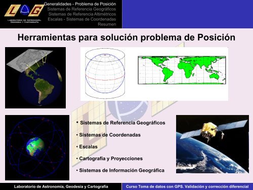
Herramientas para solución problema <strong>de</strong> Posición<br />
• <strong>Sistemas</strong> <strong>de</strong> Referencia Geográficos<br />
• <strong>Sistemas</strong> <strong>de</strong> Coor<strong>de</strong>nadas<br />
• Escalas<br />
• Cartografía y Proyecciones<br />
• <strong>Sistemas</strong> <strong>de</strong> Información Geográfica<br />
Laboratorio <strong>de</strong> Astronomía, Geo<strong>de</strong>sia y Cartografia Curso Toma <strong>de</strong> datos con GPS. Validación y corrección diferencial