Sistemas de referencia y proyecciones cartográficas.
Sistemas de referencia y proyecciones cartográficas.
Sistemas de referencia y proyecciones cartográficas.

You also want an ePaper? Increase the reach of your titles
YUMPU automatically turns print PDFs into web optimized ePapers that Google loves.
Generalida<strong>de</strong>s - Problema <strong>de</strong> Posición<br />
<strong>Sistemas</strong> <strong>de</strong> Referencia Geográficos<br />
<strong>Sistemas</strong> <strong>de</strong> Referencia Altimétricos<br />
Escalas - <strong>Sistemas</strong> <strong>de</strong> Coor<strong>de</strong>nadas<br />
Resumen<br />
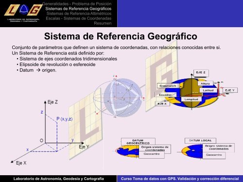
Sistema <strong>de</strong> Referencia Geográfico<br />
Conjunto <strong>de</strong> parámetros que <strong>de</strong>finen un sistema <strong>de</strong> coor<strong>de</strong>nadas, con relaciones conocidas entre si.<br />
Un Sistema <strong>de</strong> Referencia está <strong>de</strong>finido por:<br />
• Sistema <strong>de</strong> ejes coor<strong>de</strong>nados tridimensionales<br />
• Elipsoi<strong>de</strong> <strong>de</strong> revolución o esfereoi<strong>de</strong><br />
• Datum origen.<br />
Laboratorio <strong>de</strong> Astronomía, Geo<strong>de</strong>sia y Cartografia Curso Toma <strong>de</strong> datos con GPS. Validación y corrección diferencial