ESTUDIO DEL CAMBIO CLIMÁTICO, LLUVIAS ÁCIDAS Y ...
ESTUDIO DEL CAMBIO CLIMÁTICO, LLUVIAS ÁCIDAS Y ...
ESTUDIO DEL CAMBIO CLIMÁTICO, LLUVIAS ÁCIDAS Y ...

Create successful ePaper yourself
Turn your PDF publications into a flip-book with our unique Google optimized e-Paper software.
8197<br />
8196<br />
8195<br />
8194<br />
8193<br />
8192<br />
8191<br />
8190<br />
8189<br />
8188<br />
Método potencial espontáneo, volcán Ubinas y método geoquímica, vigilancia volcánica.<br />
Lag.<br />
Piscococha<br />
PS (mV.)<br />
0<br />
-500<br />
-1000<br />
-1500<br />
-2000<br />
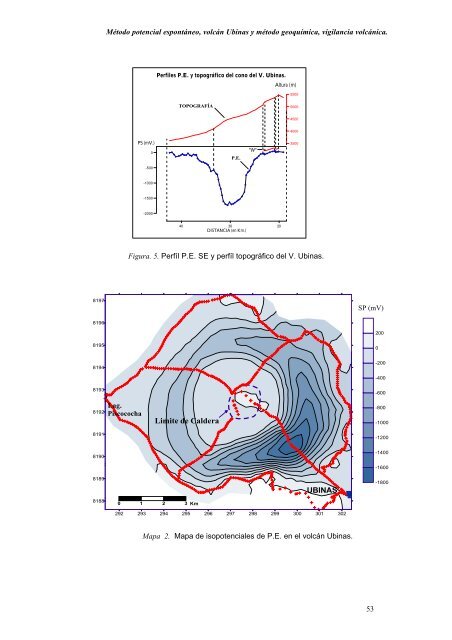
Perfiles P.E. y topográfico del cono del V. Ubinas.<br />
TOPOGRAFÍA<br />
40<br />
30<br />
DISTANCIA (en Km.)<br />
Figura. 5. Perfíl P.E. SE y perfíl topográfico del V. Ubinas.<br />
Limite de Caldera<br />
0 1 2 3 Km<br />
P.E.<br />
Altura (m)<br />
292 293 294 295 296 297 298 299 300 301 302<br />
Mapa 2. Mapa de isopotenciales de P.E. en el volcán Ubinas.<br />
"W"<br />
20<br />
5500<br />
5000<br />
4500<br />
4000<br />
3500<br />
UBINAS<br />
SP (mV)<br />
53<br />
200<br />
0<br />
-200<br />
-400<br />
-600<br />
-800<br />
-1000<br />
-1200<br />
-1400<br />
-1600<br />
-1800