Autopista Costanera Central - Municipalidad de Macul
Autopista Costanera Central - Municipalidad de Macul
Autopista Costanera Central - Municipalidad de Macul

Create successful ePaper yourself
Turn your PDF publications into a flip-book with our unique Google optimized e-Paper software.
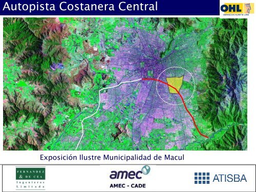
<strong>Autopista</strong> <strong>Costanera</strong> <strong>Central</strong><br />
Exposición Ilustre <strong>Municipalidad</strong> <strong>de</strong> <strong>Macul</strong><br />
<strong>Autopista</strong> <strong>Costanera</strong> <strong>Central</strong>
2 METODOLOGIA<br />
3 ALTERNATIVAS<br />
<strong>Autopista</strong> <strong>Costanera</strong> <strong>Central</strong><br />
INDICE<br />
1 DESCRIPCION PROYECTO<br />
4 PLAN INTEGRAL<br />
5 DEMANDA<br />
6 ESTIMACIÓN DE INVERSIÓN<br />
7 CONCLUSIONES
2 METODOLOGIA<br />
3 ALTERNATIVAS<br />
<strong>Autopista</strong> <strong>Costanera</strong> <strong>Central</strong><br />
INDICE<br />
1 DESCRIPCION PROYECTO<br />
4 PLAN INTEGRAL<br />
5 DEMANDA<br />
6 ESTIMACIÓN DE INVERSIÓN<br />
7 CONCLUSIONES
1.1 Características Generales<br />
- Iniciativa privada <strong>de</strong> concesión: proponente OHL Concesiones<br />
Chile S.A.<br />
- <strong>Autopista</strong> expresa <strong>de</strong> 20 kilómetros con 7 conexiones<br />
<strong>de</strong>sniveladas.<br />
- Inicio: <strong>Autopista</strong> <strong>Central</strong> con <strong>Autopista</strong> <strong>de</strong>l Sol,<br />
extendiéndose por Isabel Riquelme, Zanjón <strong>de</strong> La Aguada y<br />
Avenida La Florida.<br />
- Área <strong>de</strong> influencia 2009: 2,4 millones <strong>de</strong> habitantes en 7<br />
municipios.<br />
<strong>Autopista</strong> <strong>Costanera</strong> <strong>Central</strong>
Plano <strong>de</strong> Proyecto<br />
<strong>Autopista</strong> <strong>Costanera</strong> <strong>Central</strong><br />
P. Valdivia<br />
El Peñón
Tramos y Vías Involucradas<br />
Tramos<br />
TRAMO A 3,7 Kms<br />
I. RIQUELME<br />
TRAMO B 3,8 Kms<br />
<strong>Autopista</strong> <strong>Costanera</strong> <strong>Central</strong><br />
TRAMO C 3,7 Kms<br />
DEPARTAMENTAL<br />
TRINIDAD ORIENTE<br />
W. MARTÍNEZ<br />
R. MAGALLANES<br />
TRAMO D 12 Kms<br />
TOTAL AUTOPISTA<br />
23,2 Kms<br />
MACUL
Alcance <strong>de</strong>l Estudio<br />
Aquí vamos<br />
Diagnóstico Urbano<br />
Estudios <strong>de</strong> Base Demanda<br />
Catastros e Ingeniería Básica<br />
Presentación a Municipios<br />
Estimación <strong>de</strong> la Demanda<br />
<strong>Autopista</strong> <strong>Costanera</strong> <strong>Central</strong><br />
Fase I: Etapa <strong>de</strong> Proposición<br />
Definición Alternativas <strong>de</strong> Trazado<br />
Estimación Costos <strong>de</strong> Inversión<br />
Selección Alternativa<br />
Anteproyecto Preliminar Alternativa Seleccionada<br />
Propuesta <strong>de</strong> Diseño Urbano<br />
Costos <strong>de</strong> Inversión Definitivos Fase 1<br />
Evaluación Social Preliminar<br />
Presentación Municipios<br />
Evaluación Económica<br />
Informe Final Fase 1
Estudios Fase 0<br />
Acuerdo MOP / SECTRA<br />
Reuniones Municipios (PA-LF-SJ)<br />
Términos <strong>de</strong> Referencia<br />
Estudios Fase 1<br />
Estudios Fase 2<br />
Preparación BALI<br />
Licitación Concesión<br />
<strong>Autopista</strong> <strong>Costanera</strong> <strong>Central</strong><br />
Cronograma <strong>de</strong> Estudios<br />
2006 2007 2008 2009 2010 2011 2012 2013 2014<br />
Dic -11<br />
May - 13<br />
Jul-13<br />
Dic - 13
1.2 Justificación<br />
- Conecta principal reserva <strong>de</strong> suelo urbano con gran cantidad<br />
<strong>de</strong> proyectos inmobiliarios (Atisba).<br />
- 2009-2015: La población crecerá en 141.000 hbtes (40.400<br />
hogares). Fuente: FDC.<br />
- Los hogares que ganan sobre $760.000 pasarán <strong>de</strong> un 22% a<br />
28%. Fuente: FDC.<br />
- El número <strong>de</strong> vehículos subirá <strong>de</strong> 284.000 a 343.000 en<br />
2015 (comunas involucradas). Fuente: FDC.<br />
- ACC resolverá la conectividad <strong>de</strong> esta población con los<br />
centros <strong>de</strong> empleo y servicios.<br />
<strong>Autopista</strong> <strong>Costanera</strong> <strong>Central</strong>
1.2 Justificación<br />
- Potencia <strong>de</strong>sarrollo <strong>de</strong> subcentros <strong>de</strong> <strong>Macul</strong>, mejorando su<br />
conectividad con nuevos espacios públicos<br />
<strong>Autopista</strong> <strong>Costanera</strong> <strong>Central</strong><br />
Subcentros Potenciales
2 METODOLOGIA<br />
3 ALTERNATIVAS<br />
<strong>Autopista</strong> <strong>Costanera</strong> <strong>Central</strong><br />
INDICE<br />
1 DESCRIPCION PROYECTO<br />
4 PLAN INTEGRAL<br />
5 DEMANDA<br />
6 ESTIMACIÓN DE INVERSIÓN<br />
7 CONCLUSIONES
2.1 Las Etapas y El Equipo<br />
<strong>Autopista</strong> <strong>Costanera</strong> <strong>Central</strong><br />
DIAGNOSTICO<br />
Transporte Ingeniería<br />
Restricciones - Opciones<br />
FORMULACION ALTERNATIVAS<br />
EVALUACION<br />
Privada Social<br />
Selección Alternativa<br />
PLAN INTEGRAL<br />
Urbanismo<br />
Urbana
2.2 Diagnóstico: Principales Interferencias <strong>Macul</strong><br />
Tramo B1 – Vicuña Mackenna / Pedro <strong>de</strong> Valdivia<br />
<strong>Autopista</strong> <strong>Costanera</strong> <strong>Central</strong>
2.2 Diagnóstico: Principales Interferencias <strong>Macul</strong><br />
Sector Resi<strong>de</strong>ncial<br />
Sector Resi<strong>de</strong>ncial<br />
Tramo B2 – Pedro <strong>de</strong> Valdivia / Américo Vespucio<br />
Sector Resi<strong>de</strong>ncial<br />
<strong>Autopista</strong> <strong>Costanera</strong> <strong>Central</strong><br />
Sector Resi<strong>de</strong>ncial
2 METODOLOGIA<br />
3 ALTERNATIVAS<br />
<strong>Autopista</strong> <strong>Costanera</strong> <strong>Central</strong><br />
INDICE<br />
1 DESCRIPCION PROYECTO<br />
4 PLAN INTEGRAL<br />
5 DEMANDA<br />
6 ESTIMACIÓN DE INVERSIÓN<br />
7 CONCLUSIONES
3.1 – Criterios <strong>de</strong> Diseño<br />
Ecuación Clave<br />
TECNICA<br />
ECONOMICA URBANA<br />
CIUDADANA<br />
<strong>Autopista</strong> El Costo<strong>Costanera</strong> <strong>de</strong> inversión <strong>Central</strong> no <strong>de</strong>fine la ecuación.
3.2 – Definición <strong>de</strong> Alternativas<br />
Tramo / Alternativa Túnel<br />
1 - TÚNEL<br />
2 – TRINCHERA<br />
Trinchera<br />
CUBIERTA<br />
Trinchera +<br />
3 – TRINCHERA<br />
Viaducto<br />
+ VIADUCTO<br />
Trinchera +<br />
4 – TRINCHERA<br />
Nivel<br />
+ SUPERFICIE<br />
Trinchera +<br />
5 – Viaducto VIADUCTO + +<br />
Viaducto SUPERFICIE<br />
+ Nivel<br />
1 6A 6B 6C 6D<br />
Sector A: Bascuñán G. -<br />
<strong>Autopista</strong> <strong>Central</strong><br />
Sector B: <strong>Autopista</strong> <strong>Central</strong> -<br />
Vicuña Mackenna<br />
Sector C: Vicuña Mackenna -<br />
Américo Vespucio<br />
Sector D: Américo Vespucio - El<br />
Peñón<br />
Túnel<br />
Túnel<br />
Túnel<br />
Trinchera Semi-<br />
Cubierta<br />
<strong>Autopista</strong> <strong>Costanera</strong> <strong>Central</strong><br />
Trinchera<br />
Cubierta<br />
Trinchera<br />
Cubierta<br />
Trinchera<br />
Cubierta<br />
Trinchera Semi-<br />
Cubierta<br />
Trinchera<br />
Cubierta<br />
Trinchera<br />
Cubierta<br />
Viaducto<br />
Trinchera Semi-<br />
Cubierta<br />
Sector D: El Peñón - Eyzaguirre Superficie Superficie Superficie<br />
COSTO<br />
INVERSION<br />
M UF<br />
39.976<br />
M UF<br />
33.442<br />
M UF<br />
27.687<br />
Trinchera<br />
Cubierta<br />
Trinchera<br />
Cubierta<br />
Trinchera<br />
Cubierta<br />
Superficie<br />
M UF<br />
23.910<br />
Trinchera<br />
Cubierta<br />
Viaducto<br />
Viaducto<br />
Superficie<br />
M UF<br />
20.684
3.3 – Criterios <strong>de</strong> Evaluación<br />
# Criterio<br />
1a Complejidad Constructiva<br />
1b Desvíos <strong>de</strong> Tránsito<br />
2a Impacto en Servicios Húmedos<br />
2b Impacto en Expropiaciones<br />
3 Conectividad Vías Expresas<br />
4 Conectividad Vialidad local<br />
5 Integración Urbana<br />
<strong>Autopista</strong> <strong>Costanera</strong> <strong>Central</strong><br />
Conectividad + Calidad <strong>de</strong> Vida<br />
(para usuarios y vecinos)
La Alternativa 5 es la Más Económica…..<br />
Padre Luis Querbes<br />
<strong>Autopista</strong> <strong>Costanera</strong> <strong>Central</strong><br />
Colector<br />
ACC<br />
Zanjón<br />
Sergio Vieira <strong>de</strong> Mello<br />
......Pero resulta totalmente inviable <strong>de</strong> ejecutar en <strong>Macul</strong>
3.4 – Selección<br />
Tramo / Alternativa Túnel<br />
1 - TÚNEL<br />
2 – TRINCHERA<br />
Trinchera<br />
CUBIERTA<br />
Trinchera +<br />
3 – TRINCHERA<br />
Viaducto<br />
+ VIADUCTO<br />
Trinchera +<br />
4 – TRINCHERA<br />
Nivel<br />
+ SUPERFICIE<br />
Trinchera +<br />
5 – Viaducto VIADUCTO + +<br />
Viaducto SUPERFICIE + Nivel<br />
1 6A 6B 6C 6D<br />
Sector A: Bascuñán G. -<br />
<strong>Autopista</strong> <strong>Central</strong><br />
Sector B: <strong>Autopista</strong> <strong>Central</strong> -<br />
Vicuña Mackenna<br />
Sector C: Vicuña Mackenna -<br />
Américo Vespucio<br />
Sector D: Américo Vespucio - El<br />
Peñón<br />
Túnel<br />
Túnel<br />
Túnel<br />
Trinchera Semi-<br />
Cubierta<br />
<strong>Autopista</strong> <strong>Costanera</strong> <strong>Central</strong><br />
Trinchera<br />
Cubierta<br />
Trinchera<br />
Cubierta<br />
Trinchera<br />
Cubierta<br />
Trinchera Semi-<br />
Cubierta<br />
Trinchera<br />
Cubierta<br />
Trinchera<br />
Cubierta<br />
Viaducto<br />
Trinchera Semi-<br />
Cubierta<br />
Sector D: El Peñón - Eyzaguirre Superficie Superficie Superficie<br />
COSTO<br />
INVERSION<br />
M UF<br />
39.976<br />
PLAN INTEGRAL<br />
M UF<br />
33.442<br />
M UF<br />
27.687<br />
Trinchera<br />
Cubierta<br />
Trinchera<br />
Cubierta<br />
Trinchera<br />
Cubierta<br />
Superficie<br />
M UF<br />
23.910<br />
Trinchera<br />
Cubierta<br />
Viaducto<br />
Viaducto<br />
Superficie<br />
M UF<br />
20.684
2 METODOLOGIA<br />
3 ALTERNATIVAS<br />
<strong>Autopista</strong> <strong>Costanera</strong> <strong>Central</strong><br />
INDICE<br />
1 DESCRIPCION PROYECTO<br />
4 PLAN INTEGRAL<br />
5 DEMANDA<br />
6 ESTIMACIÓN DE INVERSIÓN<br />
7 CONCLUSIONES
Tramo Vicuña Mackenna – Américo Vespucio<br />
CENTENARIO<br />
<strong>Autopista</strong> <strong>Costanera</strong> <strong>Central</strong><br />
E 1<br />
E 2<br />
SIMBOLOGÍA<br />
E 3<br />
AUTOPISTA TÚNEL MINERO<br />
E 4<br />
AUTOPISTA TRINCHERA CUBIERTA<br />
AUTOPISTA SUPERFICIE<br />
TRAMO C 3,7 Kms<br />
E 5<br />
E 6<br />
TRINIDAD ORIENTE<br />
W. MARTÍNEZ<br />
E 7<br />
R. MAGALLANES<br />
E 8<br />
ENLACES<br />
E 1 NORTE SUR<br />
E 2 SANTA ROSA<br />
E 3 VICUÑA MACKENNA<br />
E 4 PEDRO DE VALDIVIA<br />
E 5 AMÉRICO VESPUCIO SUR<br />
E 6 WALKER MARTÍNEZ<br />
E 7 ROJAS MAGALLANES<br />
E 8 TRINIDAD ORIENTE<br />
E 9 DIEGO PORTALES<br />
E 10 EL PEÑON<br />
E 11 EYZAGUIRRE<br />
E 9<br />
E 10<br />
E 11
4.1 – Concepto Urbano: Minimización Impacto<br />
<strong>Autopista</strong> <strong>Costanera</strong> <strong>Central</strong>
4.2 – Sección Tipo<br />
<strong>Autopista</strong> <strong>Costanera</strong> <strong>Central</strong>
4.3 – Detalle Diseño<br />
Vicuña Mackenna – Pedro <strong>de</strong> Valdivia<br />
30<br />
30<br />
Construc. Pehuenche, Ene Blue, PRT,<br />
Paper Print, PRODALUM, SODAL<br />
Polpaico<br />
Colegio Saint<br />
Lawrence<br />
60<br />
60<br />
ENTEL<br />
Estación Carlos<br />
Valdovinos<br />
<strong>Autopista</strong> <strong>Costanera</strong> <strong>Central</strong><br />
E<br />
S<br />
GK, Logística Libros, COATS,<br />
AVEBE, Bellavista Oveja Tome<br />
NESTLE<br />
S<br />
E<br />
60<br />
Campus San<br />
Joaquín UC<br />
60<br />
Luis Querbes<br />
Luis Querbes
4.3 – Detalle Diseño<br />
Enlace V. Mackenna: Nuevos espacios públicos, mejor conectividad,<br />
minimización impactos<br />
<strong>Autopista</strong> <strong>Costanera</strong> <strong>Central</strong>
4.3 – Detalle Diseño<br />
Pedro <strong>de</strong> Valdivia – Américo Vespucio<br />
Campus San<br />
Joaquín UC<br />
S<br />
E<br />
Av. La Aguada<br />
<strong>Autopista</strong> <strong>Costanera</strong> <strong>Central</strong><br />
60<br />
Av. La Aguada<br />
60<br />
Condominio Las<br />
Palmas<br />
(SOCOVESA)<br />
S<br />
Estación <strong>Macul</strong><br />
E<br />
60<br />
60<br />
Supermercado<br />
Lí<strong>de</strong>r
4.3 – Detalle Diseño<br />
Enlace Vespucio - Departamental: Nuevos espacios públicos, mejor<br />
conectividad, minimización impactos<br />
<strong>Autopista</strong> <strong>Costanera</strong> <strong>Central</strong>
4.4 Expropiaciones Preliminares<br />
- Zonas <strong>de</strong> Detalle<br />
<strong>Autopista</strong> <strong>Costanera</strong> <strong>Central</strong>
4.4 Expropiaciones Preliminares<br />
- Zonas <strong>de</strong> Detalle<br />
<strong>Autopista</strong> <strong>Costanera</strong> <strong>Central</strong>
4.4 Expropiaciones Preliminares<br />
- Zonas <strong>de</strong> Detalle<br />
<strong>Autopista</strong> <strong>Costanera</strong> <strong>Central</strong>
4.4 Expropiaciones Preliminares<br />
- Zonas <strong>de</strong> Detalle<br />
<strong>Autopista</strong> <strong>Costanera</strong> <strong>Central</strong>
4.4 Expropiaciones Preliminares<br />
- Zonas <strong>de</strong> Detalle<br />
<strong>Autopista</strong> <strong>Costanera</strong> <strong>Central</strong>
4.4 Expropiaciones Preliminares<br />
- Zonas <strong>de</strong> Detalle<br />
<strong>Autopista</strong> <strong>Costanera</strong> <strong>Central</strong>
4.4 Expropiaciones Preliminares<br />
- Zonas <strong>de</strong> Detalle<br />
<strong>Autopista</strong> <strong>Costanera</strong> <strong>Central</strong>
4.4 Expropiaciones Preliminares<br />
- Zonas <strong>de</strong> Detalle<br />
<strong>Autopista</strong> <strong>Costanera</strong> <strong>Central</strong>
4.4 Expropiaciones Preliminares<br />
- Zonas <strong>de</strong> Detalle<br />
<strong>Autopista</strong> <strong>Costanera</strong> <strong>Central</strong>
4.4 Expropiaciones Preliminares<br />
- Zonas <strong>de</strong> Detalle<br />
<strong>Autopista</strong> <strong>Costanera</strong> <strong>Central</strong>
4.4 Expropiaciones Preliminares<br />
- Zonas <strong>de</strong> Detalle<br />
<strong>Autopista</strong> <strong>Costanera</strong> <strong>Central</strong>
4.4 Expropiaciones Preliminares<br />
- Zonas <strong>de</strong> Detalle<br />
<strong>Autopista</strong> <strong>Costanera</strong> <strong>Central</strong>
4.4 Expropiaciones Preliminares<br />
- Zonas <strong>de</strong> Detalle<br />
<strong>Autopista</strong> <strong>Costanera</strong> <strong>Central</strong>
4.4 Expropiaciones Preliminares<br />
- Zonas <strong>de</strong> Detalle<br />
<strong>Autopista</strong> <strong>Costanera</strong> <strong>Central</strong>
4.4 Expropiaciones Preliminares<br />
- Zonas <strong>de</strong> Detalle<br />
<strong>Autopista</strong> <strong>Costanera</strong> <strong>Central</strong>
4.4 Expropiaciones Preliminares<br />
- Zonas <strong>de</strong> Detalle<br />
<strong>Autopista</strong> <strong>Costanera</strong> <strong>Central</strong>
2 METODOLOGIA<br />
3 ALTERNATIVAS<br />
<strong>Autopista</strong> <strong>Costanera</strong> <strong>Central</strong><br />
INDICE<br />
1 DESCRIPCION PROYECTO<br />
4 PLAN INTEGRAL<br />
5 DEMANDA<br />
6 ESTIMACIÓN DE INVERSIÓN<br />
7 CONCLUSIONES
5.1 Mo<strong>de</strong>lación y Análisis <strong>de</strong> Demanda<br />
Basándose en el trabajo realizado para el estudio “Análisis <strong>de</strong>l Sistema <strong>de</strong><br />
Concesiones Urbanas 1999-2000”, se introdujeron mejoras metodológicas<br />
que incluyen:<br />
1. Un análisis <strong>de</strong>tallado <strong>de</strong> 4 períodos <strong>de</strong>l día:<br />
• Punta Mañana<br />
• Fuera <strong>de</strong> Punta<br />
• Punta Tar<strong>de</strong><br />
• Fin <strong>de</strong> Semana<br />
2. Actualización <strong>de</strong> la información disponible al inicio <strong>de</strong> este<br />
estudio, a partir <strong>de</strong> encuestas, conteos <strong>de</strong> flujo y catastros en<br />
terreno <strong>de</strong> las características <strong>de</strong> la vialidad local.<br />
3. Un tratamiento especial para las entradas y salidas <strong>de</strong> la<br />
autopista.<br />
<strong>Autopista</strong> <strong>Costanera</strong> <strong>Central</strong>
5.1 Mo<strong>de</strong>lo <strong>de</strong> Demanda<br />
<strong>Autopista</strong> <strong>Costanera</strong> <strong>Central</strong><br />
Localización <strong>de</strong> Conteos y Mediciones
5.1 Flujos Vehiculares<br />
<strong>Autopista</strong> <strong>Costanera</strong> <strong>Central</strong><br />
67.000 vehículos livianos<br />
transitan al día por ejes<br />
relevantes.<br />
(Fuente: Medición 2009)<br />
28.000 vehículos livianos<br />
transitan al día, sólo por Av. La<br />
Florida.<br />
(Fuente: Medición 2009)<br />
2.200 vehículos livianos transitan<br />
en hora punta, por Av La Florida.<br />
(Fuente: Medición 2009)<br />
En hora punta, gran parte <strong>de</strong><br />
este flujo atraviesa <strong>Macul</strong>,<br />
generando graves problemas <strong>de</strong><br />
congestión.
5.2 Transporte Privado, Situación Base, Avenida La Florida<br />
Veh / hr<br />
7000<br />
6000<br />
5000<br />
4000<br />
3000<br />
2000<br />
1000<br />
Punta Mañana, 2010<br />
Tramo:<br />
Eyzaguirre -<br />
Departamental<br />
0<br />
<strong>Autopista</strong> <strong>Costanera</strong> <strong>Central</strong><br />
Velocidad Promedio 34 km/hr<br />
Tiempo <strong>de</strong> Viaje 21 minutos<br />
Transporte Privado Capacidad
5.2 Transporte Privado, Situación Base, Avenida La Florida<br />
Veh / hr<br />
7000<br />
6000<br />
5000<br />
4000<br />
3000<br />
2000<br />
1000<br />
Punta Mañana, 2015<br />
Tramo:<br />
Eyzaguirre - Departamental<br />
0<br />
<strong>Autopista</strong> <strong>Costanera</strong> <strong>Central</strong><br />
Velocidad Promedio 26 km/hr<br />
Tiempo <strong>de</strong> Viaje 28 minutos<br />
Transporte Privado Capacidad
5.2 Transporte Privado, Situación Base, Avenida La Florida<br />
Veh / hr<br />
7000<br />
6000<br />
5000<br />
4000<br />
3000<br />
2000<br />
1000<br />
Punta Mañana, 2020<br />
Tramo:<br />
Eyzaguirre - Departamental<br />
0<br />
<strong>Autopista</strong> <strong>Costanera</strong> <strong>Central</strong><br />
Velocidad Promedio 20 km/hr<br />
Tiempo <strong>de</strong> Viaje 37 minutos<br />
Transporte Privado Capacidad
5.2 Transporte Privado, Situación Base, Avenida La Florida<br />
Veh / hr<br />
7000<br />
6000<br />
5000<br />
4000<br />
3000<br />
2000<br />
1000<br />
Punta Mañana, 2030<br />
Tramo:<br />
Eyzaguirre - Departamental<br />
0<br />
<strong>Autopista</strong> <strong>Costanera</strong> <strong>Central</strong><br />
Velocidad Promedio 16 km/hr<br />
Tiempo <strong>de</strong> Viaje 46 minutos<br />
Transporte Privado Capacidad
5.3 Transporte Privado, Situación Base, Isabel Riquelme<br />
Punta Mañana, 2010<br />
Tramo:<br />
Vicuña Mackenna – Club Hípico<br />
<strong>Autopista</strong> <strong>Costanera</strong> <strong>Central</strong><br />
Velocidad Promedio 33 km/hr<br />
Tiempo <strong>de</strong> Viaje 10 minutos
5.3 Transporte Privado, Situación Base, Isabel Riquelme<br />
Punta Mañana, 2015<br />
Tramo:<br />
Vicuña Mackenna – Club Hípico<br />
<strong>Autopista</strong> <strong>Costanera</strong> <strong>Central</strong><br />
Velocidad Promedio 25 km/hr<br />
Tiempo <strong>de</strong> Viaje 13 minutos
5.3 Transporte Privado, Situación Base, Isabel Riquelme<br />
Punta Mañana, 2020<br />
Tramo:<br />
Vicuña Mackenna – Club Hípico<br />
<strong>Autopista</strong> <strong>Costanera</strong> <strong>Central</strong><br />
Velocidad Promedio 19 km/hr<br />
Tiempo <strong>de</strong> Viaje 18 minutos
5.3 Transporte Privado, Situación Base, Isabel Riquelme<br />
Punta Mañana, 2030<br />
Tramo:<br />
Vicuña Mackenna – Club Hípico<br />
<strong>Autopista</strong> <strong>Costanera</strong> <strong>Central</strong><br />
Velocidad Promedio 14 km/hr<br />
Tiempo <strong>de</strong> Viaje 22 minutos
5.4 Evolución Tiempos <strong>de</strong> Viaje<br />
El tiempo <strong>de</strong> viaje actual <strong>de</strong>s<strong>de</strong> el cruce Vespucio/Departamental hasta el centro<br />
<strong>de</strong> Santiago toma aproximadamente 26 minutos, hora punta.<br />
La mitad <strong>de</strong> este tiempo, se emplea en cruzar la comuna <strong>de</strong> <strong>Macul</strong>.<br />
Este tiempo aumentará progresivamente a futuro, creciendo en un 33% cada 5<br />
años.<br />
El proyecto reduce el tiempo <strong>de</strong> viaje a 10 minutos hasta el centro <strong>de</strong> Santiago, al<br />
aumentar la velocidad promedio <strong>de</strong> operación a 90 km/hr en el tramo Vespucio-<br />
Ruta 5.<br />
Junto con beneficiar directamente a los usuarios <strong>de</strong>l proyecto produce una<br />
importante <strong>de</strong>scongestión <strong>de</strong> las vías locales <strong>de</strong> superficie <strong>de</strong> la comuna,<br />
beneficiando otros usuarios <strong>de</strong> transporte privado.<br />
<strong>Autopista</strong> <strong>Costanera</strong> <strong>Central</strong>
5.5 Transporte Privado, Proyecto <strong>Costanera</strong> <strong>Central</strong><br />
Punta Mañana, 2015<br />
Tramo<br />
Walker Martínez – Santa Rosa<br />
<strong>Autopista</strong> <strong>Costanera</strong> <strong>Central</strong><br />
Tramo W. Martínez – Santa Rosa<br />
Velocidad Promedio 100 km/hr<br />
Tiempo <strong>de</strong> Viaje 6 minutos
5.5 Transporte Privado, Proyecto <strong>Costanera</strong> <strong>Central</strong><br />
Punta Mañana, 2020<br />
Tramo<br />
Walker Martínez – Santa Rosa<br />
<strong>Autopista</strong> <strong>Costanera</strong> <strong>Central</strong><br />
Tramo W. Martínez – Santa Rosa<br />
Velocidad Promedio 97 km/hr<br />
Tiempo <strong>de</strong> Viaje 6 minutos
5.5 Transporte Privado, Proyecto <strong>Costanera</strong> <strong>Central</strong><br />
Punta Mañana, 2030<br />
Tramo<br />
Walker Martínez – Santa Rosa<br />
<strong>Autopista</strong> <strong>Costanera</strong> <strong>Central</strong><br />
Tramo W. Martínez – Santa Rosa<br />
Velocidad Promedio 90 km/hr<br />
Tiempo <strong>de</strong> Viaje 9 minutos
5.6 Beneficios para Usuarios <strong>de</strong> Transporte Privado<br />
Un ahorro <strong>de</strong> 15 minutos promedio para el tramo Departamental – Ruta 5, al año <strong>de</strong><br />
inicio <strong>de</strong> la operación <strong>de</strong>l proyecto,.<br />
Descongestión importante <strong>de</strong> vías locales <strong>de</strong> la comuna que son utilizadas<br />
intensivamente para viajes <strong>de</strong>s<strong>de</strong> el sur-oriente hasta el centro <strong>de</strong> la ciudad .<br />
Esta <strong>de</strong>scongestión produce a<strong>de</strong>más ahorros <strong>de</strong> tiempo para automovilistas que no<br />
son usuarios <strong>de</strong> la autopista.<br />
Tránsito medio <strong>de</strong> 3.800 vehículos en hora punta con sentido Sur – Norte, al año <strong>de</strong><br />
inicio <strong>de</strong>l proyecto.<br />
Este número <strong>de</strong> usuarios aumentará progresivamente hasta alcanzar los 5.800<br />
vehículos por hora al año 2030.<br />
Tránsito medio <strong>de</strong> 45.850 vehículos al día, al año <strong>de</strong> inicio <strong>de</strong> la concesión.<br />
Este número <strong>de</strong> usuarios alcanzará los 87.000 vehículos diarios para 2030.<br />
<strong>Autopista</strong> <strong>Costanera</strong> <strong>Central</strong>
2 METODOLOGIA<br />
3 ALTERNATIVAS<br />
<strong>Autopista</strong> <strong>Costanera</strong> <strong>Central</strong><br />
INDICE<br />
1 DESCRIPCION PROYECTO<br />
4 PLAN INTEGRAL<br />
5 DEMANDA<br />
6 ESTIMACIÓN DE INVERSIÓN<br />
7 CONCLUSIONES
<strong>Autopista</strong> <strong>Costanera</strong> <strong>Central</strong><br />
Estimación Inversión<br />
Sector / Alternativa Alternativa Seleccionada Túnel<br />
B: Ruta 5 -Vicuña Mackenna Túnel - Trinch. Cubierta Túnel<br />
C: V. Mackenna - A. Vespucio Trinch. Cubierta Túnel<br />
D: A. Vespucio - Eyzaguirre Trinch. Semi-cubierta Túnel<br />
Inversiones en MUF<br />
Obra Civil 26.135.026 36.355.028<br />
Modificación <strong>de</strong> Servicios 2.870.110 1.859.089<br />
Expropiaciones 1.236.779 1.355.304<br />
Equipos <strong>de</strong> Peaje, Control y Otros 693.231 706.435<br />
Subtotal 30.935.146 40.275.856<br />
Ingeniería, Inspección y Administración (6,5%) 2.010.784 2.617.931<br />
Imprevistos (20%) 6.589.186 8.578.757<br />
Total UF 39.535.117 51.472.544<br />
SUBSIDIO (MUF)<br />
Con subsidio a la Explotación (1) 32.120 50.050<br />
Sin Subsidio a la Explotación 34.270 52.210<br />
NOTAS:<br />
(1): Cuotas subsidio a la explotación: UF 130.000 anuales <strong>de</strong>s<strong>de</strong> inicio <strong>de</strong> explotación
2 METODOLOGIA<br />
3 ALTERNATIVAS<br />
<strong>Autopista</strong> <strong>Costanera</strong> <strong>Central</strong><br />
INDICE<br />
1 DESCRIPCION PROYECTO<br />
4 PLAN INTEGRAL<br />
5 DEMANDA<br />
6 ESTIMACIÓN DE INVERSIÓN<br />
7 CONCLUSIONES
Un Proyecto Estratégico para Santiago<br />
Complementa la red <strong>de</strong> autopista urbanas <strong>de</strong> Santiago.<br />
Resuelve la conectividad <strong>de</strong> <strong>Macul</strong>, potenciando sus<br />
subcentros y reduciendo tiempos <strong>de</strong> viaje<br />
Minimiza impactos urbanos al hundir la autopista y sus<br />
enlaces.<br />
Crea nuevos espacios públicos con calles locales que<br />
mejoran la conectividad <strong>de</strong> los vecinos con vialida<strong>de</strong>s<br />
importantes <strong>de</strong>l zona<br />
Descongestiona vialidad existente<br />
Potencia renovación urbana <strong>de</strong>l corredor Zanjón <strong>de</strong> la<br />
Aguada (corredor: parque + metro + ACC).<br />
<strong>Autopista</strong> <strong>Costanera</strong> <strong>Central</strong>
<strong>Autopista</strong> <strong>Costanera</strong> <strong>Central</strong><br />
Exposición Ilustre <strong>Municipalidad</strong> <strong>de</strong> <strong>Macul</strong><br />
<strong>Autopista</strong> <strong>Costanera</strong> <strong>Central</strong>