Puerto <strong><strong>de</strong>l</strong> arrastra<strong>de</strong>ro, ±5 km al ne <strong>de</strong> acatitlán <strong>de</strong> Zaragoza, municipio <strong>de</strong> landa, E. González 474 (ieb); -2 km al W (WsW) <strong>de</strong> Molinitos, municipio <strong>de</strong> Peñamiller, E. Carranza y E. Pérez 4670 (ieb); ±2 km al n <strong><strong>de</strong>l</strong> cerro <strong>de</strong> las antenas, municipio <strong>de</strong> Pinal <strong>de</strong> amoles, E. Carranza 2577 (ieb); parte alta <strong><strong>de</strong>l</strong> cerro Pingüical, junto a la antena <strong>de</strong> microondas, municipio <strong>de</strong> Pinal <strong>de</strong> amoles, S. Zamudio y E. Pérez 7460 (ieb); .5 km al ne <strong>de</strong> Pinal <strong>de</strong> amoles, municipio <strong>de</strong> Pinal <strong>de</strong> amoles, S. Zamudio y E. Carranza 6503 (ieb); Pinal <strong>de</strong> amoles, municipio <strong>de</strong> Pinal <strong>de</strong> amoles, S. Zamudio 2653 (ieb); 500 m al se <strong>de</strong> Pinal <strong>de</strong> amoles, municipio <strong>de</strong> Pinal <strong>de</strong> amoles, A. R. López et al. 829 (ieb); rocks above Mex. hwy 20, junct s of hwy summit at km 3 .2 (n of san juan <strong><strong>de</strong>l</strong> rio) 3 mi n of Maguey Ver<strong>de</strong>, ±5 /4 mi s of Pinal <strong>de</strong> amoles, municipio <strong>de</strong> Pinal <strong>de</strong> amoles, C. H. Uhl U1854 (MeXU); la cañada, municipio <strong>de</strong> Pinal <strong>de</strong> amoles, S. Zamudio 5352 (encb, ieb); ibid., E. Pérez y E. Carranza 3516 (ieb); W <strong>de</strong> san joaquín (23 mi ne of Vizarrón) municipio <strong>de</strong> san joaquín, C. H. Uhl U2129 ( MeXU); ±4 km <strong>de</strong> la Veracruz, rumbo a casa <strong>de</strong> Máquinas, municipio <strong>de</strong> san joaquín, E. Carranza e I. Silva 6246 (ieb); parte alta <strong><strong>de</strong>l</strong> cerro Zamorano, municipio <strong>de</strong> colón, J. Rzedowski y R. McVaugh 431 (ebUM, encb, MeXU); ibid., J. Rzedowski 44420 (ieb); ibid. E. Pérez y G. Ocampo 4306 (ieb); cerro Zamorano, en la parte alta <strong><strong>de</strong>l</strong> macizo montañoso, a 500 m <strong><strong>de</strong>l</strong> Puerto <strong><strong>de</strong>l</strong> carmen, 20°55'55'' n, 00° '20'' W, municipio <strong>de</strong> colón, L. S. Cal<strong>de</strong>rón 60 (ieb); cerro Zamorano, parte alta, pico rocoso situado al e <strong>de</strong> las instalaciones <strong>de</strong> televisa, 20°55'7'' n, 00° 0' '' W, municipio <strong>de</strong> colón, L. S. Cal<strong>de</strong>rón y D. Flores 171 (ieb); parte alta <strong><strong>de</strong>l</strong> cerro Zamorano, se <strong>de</strong> las antenas, 20°55'74'' n, 00° 0'84'' W, municipio <strong>de</strong> colón, M. Gómez et al. 563 (ieb); cerro Zamorano, la<strong>de</strong>ra se, parte media <strong><strong>de</strong>l</strong> cerro, 20°55'08'' n, 00° '75'' W, municipio <strong>de</strong> colón, L. S. Cal<strong>de</strong>rón y A. Nava-Rojo 326 (ieb); rancho Maguey Manso, municipio <strong>de</strong> tolimán, S. Zamudio 2195 (ieb); 2 km al s <strong>de</strong> Vizarrón, municipio <strong>de</strong> ca<strong>de</strong>reyta, S. Zamudio 2367 (ieb); 3.5 km al sur <strong>de</strong> Vizarrón, municipio <strong>de</strong> ca<strong>de</strong>reyta, S. Zamudio 2458 (ieb); la<strong>de</strong>ra oeste <strong>de</strong> la sierra Peña azul, 2 km al sureste <strong>de</strong> el jabalí, municipio <strong>de</strong> ca<strong>de</strong>reyta, S. Zamudio 2996 (ieb); 5 km al sur <strong>de</strong> Vizarrón, sobre el camino a ca<strong>de</strong>reyta, municipio <strong>de</strong> ca<strong>de</strong>reyta, J. Rzedowski 48712 (ieb); ±4 km al e <strong>de</strong> la laja, municipio <strong>de</strong> ca<strong>de</strong>reyta, S. Zamudio y E. Carranza 6416 (ieb); 2 km al s <strong>de</strong> sombrerete, 20°47'32'' n, 99°40' 5'' W, municipio <strong>de</strong> ca<strong>de</strong>reyta, L. Hernán<strong>de</strong>z 4557 (ieb); la<strong>de</strong>ra W <strong>de</strong> Peña <strong>de</strong> bernal, municipio <strong>de</strong> ezequiel Montes, H. Díaz B. 4859 (ieb); san juan <strong>de</strong>hedó, municipio <strong>de</strong> amealco, H. Díaz B. 6027 (ieb). Michoacán: cerca <strong>de</strong> Polvillas, municipio <strong>de</strong> epitacio Huerta, J. Rzedowski 49722 (ieb); santa cruz tanaco, la<strong>de</strong>ra se <strong><strong>de</strong>l</strong> cerro gran<strong>de</strong>, municipio <strong>de</strong> cherán, M. Pérez 200 (ieb). en nuestra área bajo estudio se le atribuyen propieda<strong>de</strong>s medicinales. 6
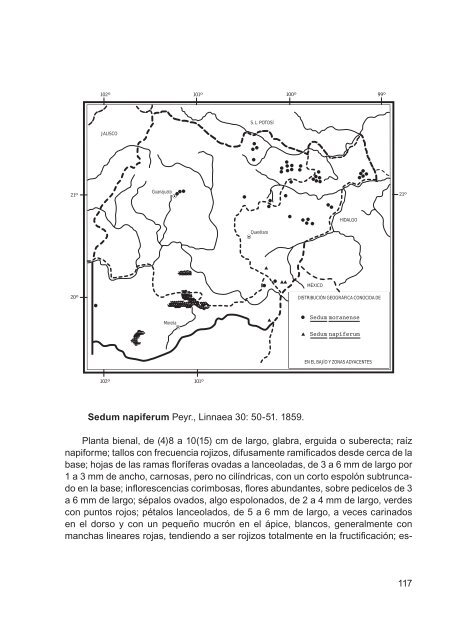
21º 20º 102º 101º 100º 99º JALISCO 102º Guanajuato Morelia 101º S. L. POTOSÍ Sedum napiferum Peyr., linnaea 30: 50-5 . 859. Planta bienal, <strong>de</strong> (4)8 a 0( 5) cm <strong>de</strong> largo, glabra, erguida o suberecta; raíz napiforme; tallos con frecuencia rojizos, difusamente ramificados <strong>de</strong>s<strong>de</strong> cerca <strong>de</strong> la base; hojas <strong>de</strong> las ramas floríferas ovadas a lanceoladas, <strong>de</strong> 3 a 6 mm <strong>de</strong> largo por a 3 mm <strong>de</strong> ancho, carnosas, pero no cilíndricas, con un corto espolón subtruncado en la base; inflorescencias corimbosas, flores abundantes, sobre pedicelos <strong>de</strong> 3 a 6 mm <strong>de</strong> largo; sépalos ovados, algo espolonados, <strong>de</strong> 2 a 4 mm <strong>de</strong> largo, ver<strong>de</strong>s con puntos rojos; pétalos lanceolados, <strong>de</strong> 5 a 6 mm <strong>de</strong> largo, a veces carinados en el dorso y con un pequeño mucrón en el ápice, blancos, generalmente con manchas lineares rojas, tendiendo a ser rojizos totalmente en la fructificación; es- Querétaro MÉXICO HIDALGO DISTRIBUCIÓN GEOGRÁFICA CONOCIDA DE Sedum moranense Sedum napiferum EN EL BAJÍO Y ZONAS ADYACENTES 21º 7
- Page 1 and 2:
flora del bajío y de regiones adya
- Page 3 and 4:
2 Hojas alternas o dispuestas en ro
- Page 5 and 6:
Planta herbácea perenne, a veces s
- Page 7 and 8:
ne de Pinal de amoles, sobre la car
- Page 9 and 10:
los erectos, con numerosas semillas
- Page 11 and 12:
género de aproximadamente 35 espec
- Page 13 and 14:
21º 20º 102º 101º 100º 99º JA
- Page 15 and 16:
4 Inflorescencia racemiforme equila
- Page 17 and 18:
Echeveria agavoides lem., ill. Hort
- Page 19 and 20:
21º 20º 102º 101º 100º 99º JA
- Page 21 and 22:
Echeveria bifurcata rose, contr. U.
- Page 23 and 24:
Peñamiller, S. Zamudio 5313 (encb,
- Page 25 and 26:
almente con una costilla poco consp
- Page 27 and 28:
Guanajuato: el banco, 0 km al sW de
- Page 29 and 30:
Echeveria gibbiflora dc., Prodr. 3:
- Page 31 and 32:
2 cm A 1 cm 1.5 cm 1.2 cm c d c d C
- Page 33 and 34:
mm de longitud, estilos evidentes;
- Page 35 and 36:
ez 3242-a (ieb); 3 km al sW de Para
- Page 37 and 38:
Planta poco abundante en las locali
- Page 39 and 40:
longitud por 3 a 4 mm de ancho, los
- Page 41 and 42:
municipio de Peñamiller, S. Zamudi
- Page 43 and 44:
se reconocen dos variedades de esta
- Page 45 and 46:
tro cerca de la base, de color rosa
- Page 47 and 48:
Querétaro: río jalpan, al n de Pa
- Page 49 and 50:
2 cm A 1 cm B C 2 cm Echeveria walt
- Page 51 and 52:
1 cm E F G 1 cm 5 mm 5 mm 2 cm Eche
- Page 53 and 54:
un tubo corto, lóbulos extendidos
- Page 55 and 56:
considerando que prospera en las pa
- Page 57 and 58:
hasta la mitad de su longitud, lób
- Page 59 and 60:
2 cm A 1 cm 1 cm Kalanchoë tubiflo
- Page 61 and 62:
de P. aff. kimnachii Moran para la
- Page 63 and 64:
8 mm 8 mm 4 mm B C D 1 cm 2 cm Pach
- Page 65 and 66: Planta herbácea o sufrútice peren
- Page 67 and 68: 21º 20º 102º 101º 100º 99º JA
- Page 69 and 70: 2 cm 2 cm a b a b 6 mm 4 mm 2 cm C
- Page 71 and 72: ovadas a elípticas, de 2 a 20 mm d
- Page 73 and 74: les no imbricadas en la inflorescen
- Page 75 and 76: nectarios de a 3 mm de largo, amari
- Page 77 and 78: 5 cáliz gamosépalo …………..
- Page 79 and 80: 9 Plantas glabras o papilosas a tub
- Page 81 and 82: Planta herbácea perenne o sufrutes
- Page 83 and 84: y E. Pérez 6436 (ieb, MeXU, Xal);
- Page 85 and 86: 5 mm E F 5 mm B 2.5 mm C 6 mm 2.5 m
- Page 87 and 88: Sedum clausenii e. Pérez-calix, ac
- Page 89 and 90: Xichú, municipio de Xichú, E. Pé
- Page 91 and 92: 9 km al ne de Vizarrón, sobre la c
- Page 93 and 94: Spellenberg 12863 (ieb); .5 km al n
- Page 95 and 96: elemento endémico de México. dgo.
- Page 97 and 98: en toda su extensión al pedicelo,
- Page 99 and 100: W de Xichú, municipio de Xichú, E
- Page 101 and 102: de guanajuato, S. Zamudio y R. M. M
- Page 103 and 104: Planta calcífila, se ha colectado
- Page 105 and 106: 21º 20º 102º 101º 100º 99º JA
- Page 107 and 108: (cHaPa, ieb, MeXU, Xal); Peña san
- Page 109 and 110: especie endémica del área de estu
- Page 111 and 112: copal, ladera ne del cerro Pingüic
- Page 113 and 114: B C D 5 mm 5 mm 8 mm a b E 1 cm a b
- Page 115: les, así como en diversos tipos de
- Page 119 and 120: madurez, estilo filiforme, estigma
- Page 121 and 122: Crece en afloramientos ígneos, en
- Page 123 and 124: ovados de .5 a 3 mm de largo; péta
- Page 125 and 126: ne de acatitlán de Zaragoza, munic
- Page 127 and 128: 2 mm 2 mm C B 1 cm 1.5 mm 0.3 mm Ti
- Page 129 and 130: Michoacán: alrededores del Puerto
- Page 131 and 132: 2 corola de color diferente al rojo
- Page 133 and 134: 21º 20º 102º 101º 100º 99º JA
- Page 135 and 136: de largo, de color rojo-purpúreo o
- Page 137 and 138: 21º 20º 102º 101º 100º 99º JA
- Page 139 and 140: índice alfabÉtico de noMbres de P
- Page 141 and 142: S. syncarpum, 06 S. tortuosum, 79,
- Page 143: 49 52 53 51 50 48 47 44 34 33 35 36