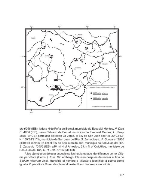
especie <strong><strong>de</strong>l</strong> centro <strong>de</strong> México. Zac., gto., Qro., Hgo., jal., Méx, d.f. (tipo <strong>de</strong> Cotyledon parvi<strong>flora</strong>: E. Bourgeau 729 (K), Pue., tlax., Ver. (tipo <strong>de</strong> Sedum miserum proce<strong>de</strong>nte <strong>de</strong> plantas cultivadas en europa a partir <strong>de</strong> semillas mexicanas (cge)). Planta sin problemas <strong>de</strong> supervivencia en la actualidad. Guanajuato: al W <strong>de</strong> jesús María, municipio <strong>de</strong> ocampo, E. Carranza 5174a (ieb); 4.5 km al s <strong>de</strong> santa bárbara, municipio <strong>de</strong> ocampo, E. Pérez 2723 (ieb); santa bárbara, cerca <strong><strong>de</strong>l</strong> río, municipio <strong>de</strong> ocampo, E. Pérez 2720 (ieb); 5 km al nW <strong>de</strong> los altos <strong>de</strong> ibarra, municipio <strong>de</strong> san felipe, R. Galván y J. D. Galván 2326 (ieb); 2 km <strong>de</strong> Mesas <strong>de</strong> jesús por el camino a Vergel <strong>de</strong> bernalejo, municipio <strong>de</strong> san luis <strong>de</strong> la Paz, E. Pérez 4783 (ieb); cerro la cantera, hacia Mesas <strong>de</strong> jesús, municipio <strong>de</strong> san luis <strong>de</strong> la Paz, E. Ventura y E. López 9532 (ieb); cerro <strong>de</strong> las antenas <strong>de</strong> Pozos, municipio <strong>de</strong> san luis <strong>de</strong> la Paz, E. Ventura y E. López 9649 (ieb); 22 km al W <strong>de</strong> Xichú, sobre la carretera a san luis <strong>de</strong> la Paz, municipio <strong>de</strong> Victoria, J. Rzedowski 41447 (ieb); Puerto <strong>de</strong> trancas, municipio <strong>de</strong> Victoria, E. Ventura y E. López 8551 (ieb); 27 km al nW <strong>de</strong> león por la carretera a san felipe torres Mochas, municipio <strong>de</strong> león, E. Pérez 4697 (ieb); 22 km al ne <strong>de</strong> león, sobre la carretera a san felipe torres Mochas, municipio <strong>de</strong> león, J. Rzedowski 52356 (ieb); cerro el cubilete, municipio <strong>de</strong> silao, E. Pérez 3935 (ieb); la<strong>de</strong>ra ssW <strong><strong>de</strong>l</strong> cerro el gigante, municipio <strong>de</strong> guanajuato, E. Pérez y J. Becerra 4048 (ieb); alre<strong>de</strong>dores <strong><strong>de</strong>l</strong> Mineral <strong>de</strong> la luz, municipio <strong>de</strong> guanajuato, J. Rzedowski 53680 (ieb); el charco, municipio <strong>de</strong> san Miguel <strong>de</strong> allen<strong>de</strong>, W. L. Meagher 10.12.06 (ieb); km al e <strong>de</strong> el capulín, en la meseta, 2 °02'0 '' n, 00° 8'42'' W, municipio <strong>de</strong> san josé iturbi<strong>de</strong>, J. Gutiérrez 587 (ieb); cerro la cañada, km al n <strong>de</strong> el charape <strong>de</strong> los Pelones, 20°54'49'' n, 00°26'56'' W, municipio <strong>de</strong> san josé iturbi<strong>de</strong>, J. Gutiérrez 517 (ieb), 538 (ieb); cerca <strong>de</strong> ixtla, municipio <strong>de</strong> apaseo el gran<strong>de</strong>, J. Rzedowski 40351 (ieb), 2 km al nW <strong>de</strong> la gavia, sobre el camino a cortazar, municipio <strong>de</strong> cortazar, J. Rzedowski 40994 (encb, ieb). Querétaro: ±6 km al ne <strong>de</strong> la lagunita <strong>de</strong> san diego, municipio <strong>de</strong> landa, E. Pérez y E. Carranza 3538 (ieb); vertiente s <strong><strong>de</strong>l</strong> cerro Zamorano, cerca <strong>de</strong> trigos, municipio <strong>de</strong> colón, J. Rzedowski 44503 (ieb); la Palma, al oeste <strong>de</strong> colón, municipio <strong>de</strong> colón, C. Orozco et al. 10257 (ieb); cerca <strong><strong>de</strong>l</strong> puente, <strong>de</strong>sviación a Maconí, carretera san joaquín - Maconí, municipio <strong>de</strong> ca<strong>de</strong>reyta, E. Pérez y E. Carranza 3963 (ieb); entronque a Maconí, carretera Vizarrón - san joaquín, 20°52'38'' n, 99°35'0 '' W, municipio <strong>de</strong> ca<strong>de</strong>reyta, E. Pérez y G. Ocampo 4280 (ieb); los juárez, municipio <strong>de</strong> ca<strong>de</strong>reyta, S. Zamudio y E. Carranza 8131 (ieb); n of san juan <strong><strong>de</strong>l</strong> rio, 2.4 km e of ca<strong>de</strong>reyta, ±4 km s of san javier, municipio <strong>de</strong> ca<strong>de</strong>reyta, C. H. Uhl U2120 (MeXU); jardín botánico regional <strong>de</strong> ca<strong>de</strong>reyta “ing. Manuel gonzález <strong>de</strong> cosío”, municipio <strong>de</strong> ca<strong>de</strong>reyta, R. Hernán<strong>de</strong>z et al. 10054 (ieb); el Vivero, ejido fuentes y Pueblo nuevo, municipio <strong>de</strong> ca<strong>de</strong>reyta, S. Zamu- 36
21º 20º 102º 101º 100º 99º JALISCO 102º Guanajuato Morelia 101º S. L. POTOSÍ Querétaro MÉXICO HIDALGO DISTRIBUCIÓN GEOGRÁFICA CONOCIDA DE Villadia misera Villadia patula EN EL BAJÍO Y ZONAS ADYACENTES dio 6968 (ieb); la<strong>de</strong>ra n <strong>de</strong> Peña <strong>de</strong> bernal, municipio <strong>de</strong> ezequiel Montes, H. Díaz B. 4860 (ieb); cerro calvario <strong>de</strong> bernal, municipio <strong>de</strong> ezequiel Montes, L. Paray 3010 (encb); parte alta <strong><strong>de</strong>l</strong> cerro la Venta, al sW <strong>de</strong> san juan <strong><strong>de</strong>l</strong> río, 20°22'43'' n, 00°0 '2 '' W, municipio <strong>de</strong> san juan <strong><strong>de</strong>l</strong> río, S. Zamudio y L. F. Guevara 13930 (ieb); el jazmín, ±5 km al sW <strong>de</strong> san juan <strong><strong>de</strong>l</strong> río, municipio <strong>de</strong> san juan <strong><strong>de</strong>l</strong> río, S. Zamudio 10555 (ieb); ± 0 mi n of amealco, 6 km n of Quiotillos, municipio <strong>de</strong> san juan <strong><strong>de</strong>l</strong> río, C. H. Uhl U2135 (MeXU). A los ejemplares <strong>de</strong> esta especie se les había estado i<strong>de</strong>ntificando como Villadia parvi<strong>flora</strong> (Hemsl.) rose. sin embargo, clausen <strong>de</strong>spués <strong>de</strong> revisar el tipo <strong>de</strong> Sedum miserum Lindl., transfirió el nombre a Villadia e i<strong>de</strong>ntificó la planta como igual a V. parvi<strong>flora</strong> rose, <strong>de</strong>splazando este último binomio a sinonimia. 21º 37
- Page 1 and 2:
flora del bajío y de regiones adya
- Page 3 and 4:
2 Hojas alternas o dispuestas en ro
- Page 5 and 6:
Planta herbácea perenne, a veces s
- Page 7 and 8:
ne de Pinal de amoles, sobre la car
- Page 9 and 10:
los erectos, con numerosas semillas
- Page 11 and 12:
género de aproximadamente 35 espec
- Page 13 and 14:
21º 20º 102º 101º 100º 99º JA
- Page 15 and 16:
4 Inflorescencia racemiforme equila
- Page 17 and 18:
Echeveria agavoides lem., ill. Hort
- Page 19 and 20:
21º 20º 102º 101º 100º 99º JA
- Page 21 and 22:
Echeveria bifurcata rose, contr. U.
- Page 23 and 24:
Peñamiller, S. Zamudio 5313 (encb,
- Page 25 and 26:
almente con una costilla poco consp
- Page 27 and 28:
Guanajuato: el banco, 0 km al sW de
- Page 29 and 30:
Echeveria gibbiflora dc., Prodr. 3:
- Page 31 and 32:
2 cm A 1 cm 1.5 cm 1.2 cm c d c d C
- Page 33 and 34:
mm de longitud, estilos evidentes;
- Page 35 and 36:
ez 3242-a (ieb); 3 km al sW de Para
- Page 37 and 38:
Planta poco abundante en las locali
- Page 39 and 40:
longitud por 3 a 4 mm de ancho, los
- Page 41 and 42:
municipio de Peñamiller, S. Zamudi
- Page 43 and 44:
se reconocen dos variedades de esta
- Page 45 and 46:
tro cerca de la base, de color rosa
- Page 47 and 48:
Querétaro: río jalpan, al n de Pa
- Page 49 and 50:
2 cm A 1 cm B C 2 cm Echeveria walt
- Page 51 and 52:
1 cm E F G 1 cm 5 mm 5 mm 2 cm Eche
- Page 53 and 54:
un tubo corto, lóbulos extendidos
- Page 55 and 56:
considerando que prospera en las pa
- Page 57 and 58:
hasta la mitad de su longitud, lób
- Page 59 and 60:
2 cm A 1 cm 1 cm Kalanchoë tubiflo
- Page 61 and 62:
de P. aff. kimnachii Moran para la
- Page 63 and 64:
8 mm 8 mm 4 mm B C D 1 cm 2 cm Pach
- Page 65 and 66:
Planta herbácea o sufrútice peren
- Page 67 and 68:
21º 20º 102º 101º 100º 99º JA
- Page 69 and 70:
2 cm 2 cm a b a b 6 mm 4 mm 2 cm C
- Page 71 and 72:
ovadas a elípticas, de 2 a 20 mm d
- Page 73 and 74:
les no imbricadas en la inflorescen
- Page 75 and 76:
nectarios de a 3 mm de largo, amari
- Page 77 and 78:
5 cáliz gamosépalo …………..
- Page 79 and 80:
9 Plantas glabras o papilosas a tub
- Page 81 and 82:
Planta herbácea perenne o sufrutes
- Page 83 and 84:
y E. Pérez 6436 (ieb, MeXU, Xal);
- Page 85 and 86: 5 mm E F 5 mm B 2.5 mm C 6 mm 2.5 m
- Page 87 and 88: Sedum clausenii e. Pérez-calix, ac
- Page 89 and 90: Xichú, municipio de Xichú, E. Pé
- Page 91 and 92: 9 km al ne de Vizarrón, sobre la c
- Page 93 and 94: Spellenberg 12863 (ieb); .5 km al n
- Page 95 and 96: elemento endémico de México. dgo.
- Page 97 and 98: en toda su extensión al pedicelo,
- Page 99 and 100: W de Xichú, municipio de Xichú, E
- Page 101 and 102: de guanajuato, S. Zamudio y R. M. M
- Page 103 and 104: Planta calcífila, se ha colectado
- Page 105 and 106: 21º 20º 102º 101º 100º 99º JA
- Page 107 and 108: (cHaPa, ieb, MeXU, Xal); Peña san
- Page 109 and 110: especie endémica del área de estu
- Page 111 and 112: copal, ladera ne del cerro Pingüic
- Page 113 and 114: B C D 5 mm 5 mm 8 mm a b E 1 cm a b
- Page 115 and 116: les, así como en diversos tipos de
- Page 117 and 118: 21º 20º 102º 101º 100º 99º JA
- Page 119 and 120: madurez, estilo filiforme, estigma
- Page 121 and 122: Crece en afloramientos ígneos, en
- Page 123 and 124: ovados de .5 a 3 mm de largo; péta
- Page 125 and 126: ne de acatitlán de Zaragoza, munic
- Page 127 and 128: 2 mm 2 mm C B 1 cm 1.5 mm 0.3 mm Ti
- Page 129 and 130: Michoacán: alrededores del Puerto
- Page 131 and 132: 2 corola de color diferente al rojo
- Page 133 and 134: 21º 20º 102º 101º 100º 99º JA
- Page 135: de largo, de color rojo-purpúreo o
- Page 139 and 140: índice alfabÉtico de noMbres de P
- Page 141 and 142: S. syncarpum, 06 S. tortuosum, 79,
- Page 143: 49 52 53 51 50 48 47 44 34 33 35 36