Perú: Megantoni - The Field Museum
Perú: Megantoni - The Field Museum
Perú: Megantoni - The Field Museum

You also want an ePaper? Increase the reach of your titles
YUMPU automatically turns print PDFs into web optimized ePapers that Google loves.
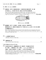
Río Timpía<br />
FIG.2 En la vertiente oriental de los Andes, el escarpado y<br />
espectacular terreno de la Zona Reservada <strong>Megantoni</strong> varia en elevaciones<br />
entre 500 y 4000 m. En esta imagen de satélite compuesta<br />
(2000/2001/2002) resaltamos los ríos más grandes dentro de<br />
<strong>Megantoni</strong>, algunos distintos tipos de vegetación, y los tres<br />
campamentos del inventario. Por ser una imagen compuesta, el<br />
bambú aparece en dos distintos colores./<br />
3<br />
Situated on the eastern slopes of the Andes, the rugged,<br />
spectacular terrain of the Zona Reservada <strong>Megantoni</strong> varies in elevation<br />
from 500-4000 m. In this composite satellite image (2000/2001/2002)<br />
we highlight the major rivers within <strong>Megantoni</strong>, several outstanding<br />
vegetation types, and our three inventory sites. Because this is a<br />
composite image, bamboo appears in two distinct colors.