Imágenes
Imágenes
Imágenes

Create successful ePaper yourself
Turn your PDF publications into a flip-book with our unique Google optimized e-Paper software.
Pre. Coop.<br />
el Triunfo<br />
Puerto Libre<br />
Río Totoa Nai´qui<br />
Kilómetros/Kilometers<br />
Río Aguarico<br />
Río Pisorié<br />
0 0.5 1 2<br />
LEyEnDA/LEgEnD<br />
Comunidad<br />
Pisorié Canqque<br />
Sitio del Inventario/Inventory Site<br />
Camp 1: Pisorié Setsa’cco<br />
Camp 2: Baboroe<br />
Camp 3: Totoa nai’qui<br />
Comunidades y Asentimientos/<br />
Communities and Settlements<br />
Comunidad Cofan/<br />
Cofan Community<br />
Centro Poblado/<br />
Colonist Settlement<br />
Camp 3<br />
Comunidad<br />
Baboroé<br />
Río Quebrada Grande<br />
Camp 2<br />
Río Castillequi<br />
Río Totoa Nai´qui<br />
Via/Road<br />
Oleoducto/Oil Pipe<br />
Río/River<br />
Reserva Mundae<br />
Caza prohibida/<br />
no hunting<br />
Deforestado/Chacras<br />
Deforested/Farm Land<br />
Bosque Denso<br />
Dense Forest<br />
<br />
Coop. Sol Naciente<br />
Comunidad<br />
Dureno<br />
Río Pisorié<br />
Pre. Coop.<br />
24 de Mayo<br />
Comunidad Totoa Naiqui<br />
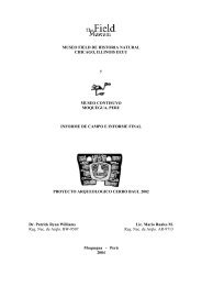
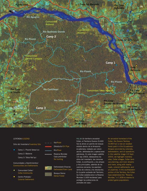
FIG.2B Un territorio ancestral<br />
Cofan, el Territorio Dureno (9,469<br />
ha) es ahora un parche de bosque<br />
aislado dentro de la Amazonía<br />
ecuatoriana, rodeado por colonización,<br />
deforestación y operaciones<br />
petroleras. En esta imagen satélite<br />
(15 sep 2003), destacamos los<br />
sitios del inventario, las comunas<br />
Cofan, la zonificación, y los arroyos<br />
y ríos principales, además de los<br />
caminos cercanos, los asentamientos<br />
de colonos y los oleoductos.<br />
En la parte sudoeste del Territorio,<br />
los Cofan establecieron la Reserva<br />
Mundae (1,928 hectáreas) para<br />
proteger las poblaciones de<br />
animales de caza./<br />
Camp 1<br />
Pre. Coop.<br />
Echandía<br />
Río Pisorié<br />
Pre. Coop<br />
Estrella del Oriente<br />
Coop. 12 de Octubre<br />
Pre. Coop.<br />
28 de Marzo<br />
Coop.<br />
Bellavista<br />
Pre. Coop.<br />
28 de Marzo<br />
An ancestral homeland of the<br />
Cofan, the Dureno Territory<br />
(9,469 ha) is now an isolated<br />
forest patch in the Ecuadorean<br />
Amazon encircled by colonists,<br />
deforestation, and oil operations.<br />
In this satellite image (15 Sept.<br />
2003), we highlight inventory<br />
sites, Cofan villages, Cofan landuse<br />
planning, and main streams<br />
and rivers, along with nearby<br />
roads, colonist settlements, and<br />
oil pipelines. In the southwestern<br />
portion of the Territory, the Cofan<br />
have established the “Reserva<br />
Mundae,” a 1,928-ha reserve to<br />
protect game populations.<br />
2B<br />
Pre. Coop.<br />
Paz y Progreso