00_cubiertas 38 v1 - Asociación Española de Teledetección
00_cubiertas 38 v1 - Asociación Española de Teledetección
00_cubiertas 38 v1 - Asociación Española de Teledetección

You also want an ePaper? Increase the reach of your titles
YUMPU automatically turns print PDFs into web optimized ePapers that Google loves.
Contribution to the management of the sensitive spaces by the geographical... 89<br />
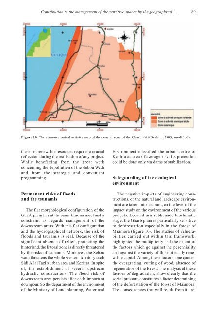
Figure 10. The sismotectonical activity map of the coastal zone of the Gharb, (Ait Brahim, 2<strong>00</strong>3, modified).<br />
these not renewable resources requires a crucial<br />
reflection during the realization of any project.<br />
While benefitting from the great wotk<br />
concerning the <strong>de</strong>pollution of the Sebou Wadi<br />
and from the strategic and convenient<br />
programming.<br />
Permanent risks of floods<br />
and the tsunamis<br />
The flat morphological configuration of the<br />
Gharb plain has at the same time an asset and a<br />
constraint as regards management of the<br />
downstream areas. With this flat configuration<br />
and the hydrographical network, the risk of<br />
floods and tsunamis is real. Because of the<br />
significant absence of reliefs protecting the<br />
hinterland, the littoral zone is directly threatened<br />
by the risks of tsunamis. Moreover, the Sebou<br />
wadi threatens the whole western territory such<br />
Sidi Allal Tazi’s urban area and Kenitra. In spite<br />
of, the establishment of several upstream<br />
hydraulic constructions. The flood risk of<br />
downstream area persists after each important<br />
downpour. So the <strong>de</strong>partment of the environment<br />
of the Ministry of Land planning, Water and<br />
Environment classified the urban centre of<br />
Kenitra as area of average risk. Its protection<br />
could be done only via dams of stabilization.<br />
Safeguarding of the ecological<br />
environment<br />
The negative impacts of engineering constructions,<br />
on the natural and landscape environment<br />
are taken into account, on the level of the<br />
impact study on the environment of the various<br />
projects. Located in a subhumi<strong>de</strong> bioclimatic<br />
stage, the Gharb plain is particularly sensitive<br />
to <strong>de</strong>forestation especially in the forest of<br />
Maâmora (figure 10). The studies of vulnerabilities<br />
carried out within this framework,<br />
highlighted the multiplicity and the extent of<br />
the factors which go against the perenniality<br />
and against the variety of this not easily renewable<br />
capital. Among these factors, one quotes:<br />
the overgrazing, cutting of wood, absence of<br />
regeneration of the forest. The analysis of these<br />
factors of <strong>de</strong>gradation, show clearly that the<br />
social pressure constitutes a factor <strong>de</strong>termining<br />
of the <strong>de</strong>forestation of the forest of Maâmora.<br />
The consequences that will result from it are: