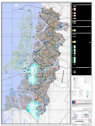
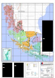
C. Plan <strong>de</strong> equidad con enfoque <strong>de</strong> género regional: Plan referido a disminuir las inequida<strong>de</strong>s <strong>de</strong> género y territoriales presentadas en la Región <strong>de</strong>l Maule, sobre la base <strong>de</strong> la ejecución <strong>de</strong> políticas públicas <strong>de</strong> infraestructura, sobre todo <strong>de</strong> reconstrucción. Plan Director <strong>de</strong> Infraestructura al 2025 <strong>de</strong>l Ministerio <strong>de</strong> Obras Públicas Su objetivo general es contribuir al aumento <strong>de</strong> la competitividad <strong>de</strong>l país y a la mejoría <strong>de</strong> la calidad <strong>de</strong> vida <strong>de</strong> la población, concentrando la inversión pública en sectores y territorios don<strong>de</strong> la rentabilidad social es más alta, pero con la <strong>de</strong>bida equidad social y territorial. Aspecto central <strong>de</strong>l estudio lo constituye, la i<strong>de</strong>ntificación <strong>de</strong> planes <strong>de</strong> inversión en infraestructura, para establecer un conjunto <strong>de</strong> obras tendientes a contribuir <strong>de</strong> manera relevante a alcanzar el potencial <strong>de</strong> <strong>de</strong>sarrollo <strong>de</strong>l territorio o superar <strong>de</strong>ficiencias <strong>de</strong> infraestructura, y a establecer conjuntos <strong>de</strong> proyectos e iniciativas consistentes entre sí, que permitan configurar actuaciones sinérgicas relevantes en el territorio. Se establecieron los siguientes lineamientos que se <strong>de</strong>rivan <strong>de</strong>l PDI. • Generar un “Arco Poniente”, que complemente el oriente actualmente en <strong>de</strong>sarrollo, logrando mejorar accesibilidad <strong>de</strong>l secano interior y un nuevo cruce <strong>de</strong>l Río Maule. • Mejorar accesos a puertos, tanto <strong>de</strong> la Región <strong>de</strong> Valparaíso como <strong>de</strong>l Biobío. • Generar un nuevo eje <strong>de</strong> conectividad norte-sur que empalme con el futuro brazo poniente <strong>de</strong>l Camino <strong>de</strong> la Fruta en la Región <strong>de</strong> O’Higgins. • Seguir construyendo obras <strong>de</strong> riego, especialmente en secanos interior y costero. • Pavimentar red secundaria para permitir agricultura <strong>de</strong> mayor valor agregado. • Crear y mejorar accesos a <strong>de</strong>stinos turísticos. • Construir solución vial para flujos <strong>de</strong> paso: bypass, circunvalación, variante, entre otras. 3.7 Síntesis Análisis Territorial La Estrategia Regional <strong>de</strong> Desarrollo <strong>de</strong> la Región <strong>de</strong>l Maule contempla siete Territorios <strong>de</strong> Planificación coordinados <strong>de</strong>s<strong>de</strong> el punto <strong>de</strong> vista técnico y operativo. Dichos territorios se encuentran insertos <strong>de</strong>ntro <strong>de</strong> la actual división político-administrativa <strong>de</strong> la región. Estos se observan en la Figura 6 como Unida<strong>de</strong>s Territoriales Homogéneas (UTH) y son los que se utilizarán en la propuesta territorial <strong>de</strong> este Plan <strong>de</strong> Infraestructura y Gestión <strong>de</strong>l Recurso Hídrico: • Territorio 1: Cuenca <strong>de</strong>l Mataquito (Vichuquén, Hualañé, Licantén y Rauco). • Territorio 3: Área Poniente <strong>de</strong> la Provincia <strong>de</strong> Talca (Pencahue, Curepto, Constitución y Empedrado). • Territorio 4: Valle Central y Precordillera <strong>de</strong> Talca (Talca, Río Claro, San Rafael, Pelarco, Maule y San Clemente). • Territorio 5: Maule Sur (Cauquenes, Chanco y Pelluhue). • Territorio 6: Área <strong>de</strong> Influencia Proyecto Embalse Ancoa (Linares, Villa Alegre, Yerbas Buenas, Colbún y San Javier). • Territorio 7: Asociación <strong>de</strong> Municipios (Longaví, Retiro y Parral). • Territorio 2: Valle Central y Precordillera <strong>de</strong> Curicó (Curicó, Teno, Romeral, Sagrada Familia y Molina). 17
Capítulo 3 | Análisis Territorial Figura 6: Unida<strong>de</strong>s Territoriales Homogéneas (UTH) Fuente: Informe GORE Maule, Modificado DIRPLAN, 2011. 18