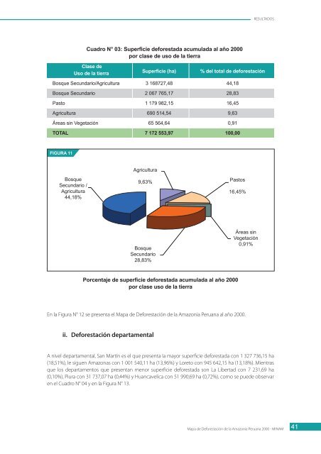
RESULTADOS3.1 Superficie <strong>de</strong> <strong>la</strong> selva amazónica peruanaEl presente trabajo ha permitido obtener con mayor <strong>de</strong>talle y precisión los límites geográficos naturales <strong>de</strong><strong>la</strong> selva amazónica, consi<strong>de</strong>rado como un gran ecosistema (ver <strong>Mapa</strong> <strong>de</strong> <strong>la</strong> <strong>Deforestación</strong>); se obtuvo unasuperficie que ascien<strong>de</strong> a 77 535 348 ha, que representa el 60,3% <strong>de</strong> <strong>la</strong> superficie total <strong>de</strong>l país.Esta superficie incluye los bosques húmedos que existen <strong>de</strong>s<strong>de</strong> el nivel más bajo <strong>de</strong> los gran<strong>de</strong>s ríos hastaaproximadamente 3 880 msnm, en <strong>la</strong>s zonas sur y centro, y hasta los 3 000 - 3 200 msnm, aproximadamenteen el extremo norte <strong>de</strong>l país; asimismo, a los bosques húmedos con periodo seco, ubicados en el fondo <strong>de</strong>algunos valles. Obviamente se incluyen todas <strong>la</strong>s áreas <strong>de</strong>forestadas, objeto <strong>de</strong>l presente estudio. Formantambién parte <strong>de</strong> este ecosistema <strong>la</strong> red hidrográfica (ríos, quebradas, p<strong>la</strong>yones, <strong>la</strong>gos y <strong>la</strong>gunas). Ver AnexoN° 06.Por otro <strong>la</strong>do, todas <strong>la</strong>s porciones <strong>de</strong> pequeños “pajonales” naturales, encerrados por el bosque natural yque a manera <strong>de</strong> pequeñas is<strong>la</strong>s se encuentran dispersas en algunas cimas <strong>de</strong>l bosque montañoso, pasana formar parte <strong>de</strong>l ecosistema selva amazónica.En cuanto a <strong>la</strong> superficie neta <strong>de</strong> los bosques húmedos y aquéllos con periodo seco calcu<strong>la</strong>da al año <strong>2000</strong>,ésta ascien<strong>de</strong> a 69 247 264 ha, que representa el 53,9% <strong>de</strong> <strong>la</strong> superficie total <strong>de</strong>l país, que se calcu<strong>la</strong> en 77352 684 ha.Para fines <strong>de</strong>l presente estudio, los límites <strong>de</strong> <strong>la</strong> selva amazónica excluyen a <strong>la</strong>s áreas adyacentes, conectadascon bosque natural y/o con áreas antrópicas, comprendidas en ambientes semiáridos y que, según el <strong>Mapa</strong><strong>de</strong> Zonas <strong>de</strong> Vida, correspon<strong>de</strong> a un monte espinoso.3.2 Superficie <strong>de</strong>forestada en <strong>la</strong> <strong>Amazonía</strong> peruanai. <strong>Deforestación</strong> nacionalA nivel nacional, el presente estudio encontró una superficie <strong>de</strong>forestada acumu<strong>la</strong>da al año <strong>2000</strong> para <strong>la</strong><strong>Amazonía</strong> peruana <strong>de</strong> 7 172 553,97 ha, que representa el 9,25% <strong>de</strong> <strong>la</strong> superficie <strong>de</strong> los bosques húmedosamazónicos <strong>de</strong>l país y el 5,58% <strong>de</strong>l territorio nacional.La c<strong>la</strong>se <strong>de</strong> uso <strong>de</strong> <strong>la</strong> tierra que presenta mayor superficie es <strong>la</strong> c<strong>la</strong>se mixta Bosque Secundario/Agricultura,con 3 168 727,48 ha, es <strong>de</strong>cir, un 44,18% <strong>de</strong>l total <strong>de</strong>forestado al año <strong>2000</strong>; por el contrario, <strong>la</strong> c<strong>la</strong>se quepresenta <strong>la</strong> menor superficie es <strong>la</strong> c<strong>la</strong>se <strong>de</strong> Áreas sin Vegetación con 65 564,64 ha (0,91% <strong>de</strong>l total <strong>de</strong>superficie <strong>de</strong>forestada).El Cuadro N° 03 y <strong>la</strong> Figura N° 11 presentan <strong>la</strong>s superficies <strong>de</strong>forestadas y sus respectivos porcentajes para<strong>la</strong>s cinco (5) c<strong>la</strong>ses <strong>de</strong> uso <strong>de</strong> <strong>la</strong> tierra que el presente estudio encontró.40<strong>Mapa</strong> <strong>de</strong> <strong>Deforestación</strong> <strong>de</strong> <strong>la</strong> <strong>Amazonía</strong> <strong>Peruana</strong> <strong>2000</strong> - MINAM
RESULTADOSCuadro N° 03: Superficie <strong>de</strong>forestada acumu<strong>la</strong>da al año <strong>2000</strong>por c<strong>la</strong>se <strong>de</strong> uso <strong>de</strong> <strong>la</strong> tierraC<strong>la</strong>se <strong>de</strong>Uso <strong>de</strong> <strong>la</strong> tierraSuperficie (ha)% <strong>de</strong>l total <strong>de</strong> <strong>de</strong>forestaciónBosque Secundario/Agricultura 3 168727,48 44,18Bosque Secundario 2 067 765,17 28,83Pasto 1 179 982,15 16,45Agricultura 690 514,54 9,63Áreas sin Vegetación 65 564,64 0,91TOTAL 7 172 553,97 100,00FIGURA 11AgriculturaBosqueSecundario /Agricultura44,18%9,63%Pastos16,45%BosqueSecundario28,83%Áreas sinVegetación0,91%Porcentaje <strong>de</strong> superficie <strong>de</strong>forestada acumu<strong>la</strong>da al año <strong>2000</strong>por c<strong>la</strong>se uso <strong>de</strong> <strong>la</strong> tierraEn <strong>la</strong> Figura N° 12 se presenta el <strong>Mapa</strong> <strong>de</strong> <strong>Deforestación</strong> <strong>de</strong> <strong>la</strong> <strong>Amazonía</strong> <strong>Peruana</strong> al año <strong>2000</strong>.ii. <strong>Deforestación</strong> <strong>de</strong>partamentalA nivel <strong>de</strong>partamental, San Martín es el que presenta <strong>la</strong> mayor superficie <strong>de</strong>forestada con 1 327 736,15 ha(18,51%), le siguen Amazonas con 1 001 540,11 ha (13,96%) y Loreto con 945 642,15 ha (13,18%). Mientrasque los <strong>de</strong>partamentos que presentan menor superficie <strong>de</strong>forestada son La Libertad con 7 231,69 ha(0,10%), Piura con 31 737,07 ha (0,44%) y Huancavelica con 51 990,69 ha (0,72%), como se pue<strong>de</strong> observaren el Cuadro N° 04 y en <strong>la</strong> Figura N° 13.<strong>Mapa</strong> <strong>de</strong> <strong>Deforestación</strong> <strong>de</strong> <strong>la</strong> <strong>Amazonía</strong> <strong>Peruana</strong> <strong>2000</strong> - MINAM41