Diagnostic des cours d'eau sur le territoire de la METRO
Diagnostic des cours d'eau sur le territoire de la METRO
Diagnostic des cours d'eau sur le territoire de la METRO

You also want an ePaper? Increase the reach of your titles
YUMPU automatically turns print PDFs into web optimized ePapers that Google loves.
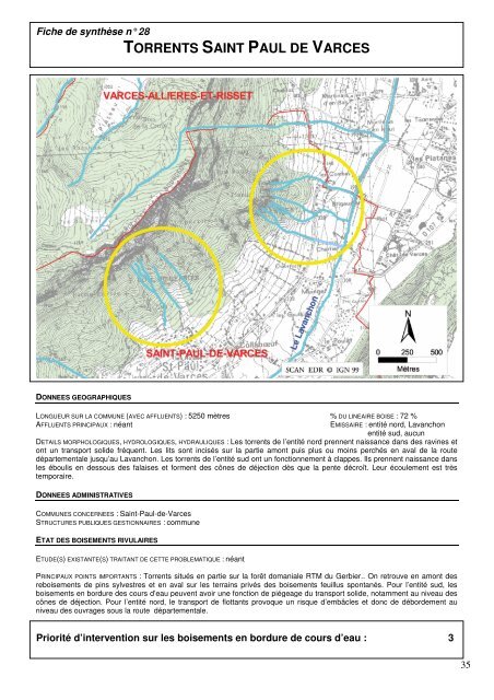
Fiche <strong>de</strong> synthèse n° 28<br />
TORRENTS SAINT PAUL DE VARCES<br />
DONNEES GEOGRAPHIQUES<br />
LONGUEUR SUR LA COMMUNE (AVEC AFFLUENTS) : 5250 mètres % DU LINEAIRE BOISE : 72 %<br />
AFFLUENTS PRINCIPAUX : néant EMISSAIRE : entité nord, Lavanchon<br />
entité sud, aucun<br />
DETAILS MORPHOLOGIQUES, HYDROLOGIQUES, HYDRAULIQUES : Les torrents <strong>de</strong> l’entité nord prennent naissance dans <strong><strong>de</strong>s</strong> ravines et<br />
ont un transport soli<strong>de</strong> fréquent. Les lits sont incisés <strong>sur</strong> <strong>la</strong> partie amont puis plus ou moins perchés en aval <strong>de</strong> <strong>la</strong> route<br />
départementa<strong>le</strong> jusqu’au Lavanchon. Les torrents <strong>de</strong> l’entité sud ont un fonctionnement à c<strong>la</strong>ppes. Ils prennent naissance dans<br />
<strong>le</strong>s éboulis en <strong><strong>de</strong>s</strong>sous <strong><strong>de</strong>s</strong> fa<strong>la</strong>ises et forment <strong><strong>de</strong>s</strong> cônes <strong>de</strong> déjection dès que <strong>la</strong> pente décroît. Leur écou<strong>le</strong>ment est très<br />
temporaire.<br />
DONNEES ADMINISTRATIVES<br />
COMMUNES CONCERNEES : Saint-Paul-<strong>de</strong>-Varces<br />
STRUCTURES PUBLIQUES GESTIONNAIRES : commune<br />
ETAT DES BOISEMENTS RIVULAIRES<br />
ETUDE(S) EXISTANTE(S) TRAITANT DE CETTE PROBLEMATIQUE : néant<br />
PRINCIPAUX POINTS IMPORTANTS : Torrents situés en partie <strong>sur</strong> <strong>la</strong> forêt domania<strong>le</strong> RTM du Gerbier.. On retrouve en amont <strong><strong>de</strong>s</strong><br />
reboisements <strong>de</strong> pins sylvestres et en aval <strong>sur</strong> <strong>le</strong>s terrains privés <strong><strong>de</strong>s</strong> boisements feuillus spontanés. Pour l’entité sud, <strong>le</strong>s<br />
boisements en bordure <strong><strong>de</strong>s</strong> <strong>cours</strong> d’eau peuvent avoir une fonction <strong>de</strong> piégeage du transport soli<strong>de</strong>, notamment au niveau <strong><strong>de</strong>s</strong><br />
cônes <strong>de</strong> déjection. Pour l’entité nord, <strong>le</strong> transport <strong>de</strong> flottants provoque un risque d’embâc<strong>le</strong>s et donc <strong>de</strong> débor<strong>de</strong>ment au<br />
niveau <strong><strong>de</strong>s</strong> ouvrages sous <strong>la</strong> route départementa<strong>le</strong>.<br />
Priorité d’intervention <strong>sur</strong> <strong>le</strong>s boisements en bordure <strong>de</strong> <strong>cours</strong> d’eau : 3<br />
35