Géomorphosites 2009
Géomorphosites 2009
Géomorphosites 2009

Create successful ePaper yourself
Turn your PDF publications into a flip-book with our unique Google optimized e-Paper software.
<strong>Géomorphosites</strong> <strong>2009</strong> : imagerie, inventaire, mise en valeur et vulgarisation du patrimoine géomorphologique<br />
Geomorphosites <strong>2009</strong>: raising the profile of geomorphological heritage<br />
through iconography, inventory and promotion<br />
Colloque international de Géomorphologie<br />
Université Paris-Sorbonne (France) – 10-11-12 juin <strong>2009</strong><br />
International Symposium on Geomorphology<br />
Paris-Sorbonne University (France) – <strong>2009</strong>, June 10, 11, 12<br />
<strong>Géomorphosites</strong> <strong>2009</strong> : imagerie, inventaire,<br />
mise en valeur et vulgarisation<br />
du patrimoine géomorphologique<br />
Geomorphosites <strong>2009</strong>: raising the profile of<br />
geomorphological heritage through iconography,<br />
inventory and promotion<br />
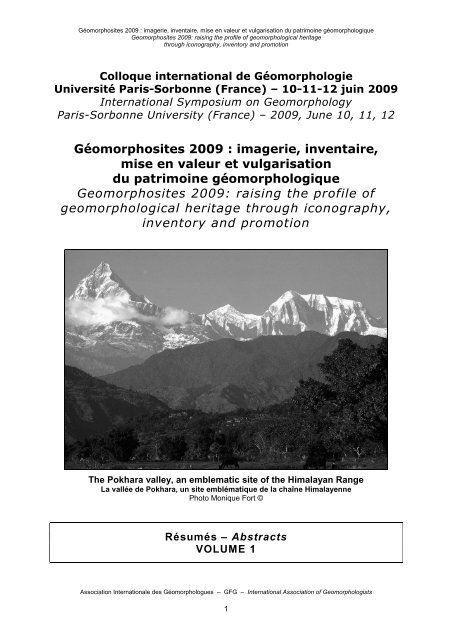
The Pokhara valley, an emblematic site of the Himalayan Range<br />
La vallée de Pokhara, un site emblématique de la chaîne Himalayenne<br />
Photo Monique Fort ©<br />
*<br />
Résumés – Abstracts<br />
VOLUME 1<br />
*<br />
Association Internationale des Géomorphologues – GFG – International Association of Geomorphologists<br />
1
<strong>Géomorphosites</strong> <strong>2009</strong> : imagerie, inventaire, mise en valeur et vulgarisation du patrimoine géomorphologique<br />
Geomorphosites <strong>2009</strong>: raising the profile of geomorphological heritage<br />
through iconography, inventory and promotion<br />
Association Internationale des Géomorphologues – GFG – International Association of Geomorphologists<br />
2
<strong>Géomorphosites</strong> <strong>2009</strong> : imagerie, inventaire, mise en valeur et vulgarisation du patrimoine géomorphologique<br />
Geomorphosites <strong>2009</strong>: raising the profile of geomorphological heritage<br />
through iconography, inventory and promotion<br />
“You have seen Ents, O King, Ents out of Fangorn Forest,<br />
which in your tongue you call Ent wood. Did you think that the<br />
name was given only in idle fancy? Nay, Théoden, it is<br />
otherwise: to them you are but the passing tale; all the years from<br />
Eorl the Young to Théoden the Old are of little count to them;<br />
and all the deeds of your house but a small matter. The King<br />
was silent…”<br />
J.R.R. TOLKIEN<br />
The Lord of the Rings, The Two Towers<br />
The Road to Isengard<br />
Association Internationale des Géomorphologues – GFG – International Association of Geomorphologists<br />
3<br />
« Vous avez vu des Ents, ô Roi, des Ents de la Forêt<br />
de Fangorn, que vous appelez dans votre langue Forêt d’Ent.<br />
Pensiez-vous que ce nom avait été donné par simple fantaisie ?<br />
Non, Théoden, il en va autrement : pour eux, vous n’êtes que<br />
l’histoire passagère ! Toutes les années écoulées depuis Eorl le<br />
Jeune jusqu’à Théoden le Vieux ne représentent pas grand chose<br />
pour eux, et tous les exploits de votre maison ne sont que<br />
broutilles. – Le Roi resta silencieux… »<br />
J.R.R. TOLKIEN<br />
Le Seigneur des Anneaux, Les Deux Tours<br />
Sur la route de l’Isengard
<strong>Géomorphosites</strong> <strong>2009</strong> : imagerie, inventaire, mise en valeur et vulgarisation du patrimoine géomorphologique<br />
Geomorphosites <strong>2009</strong>: raising the profile of geomorphological heritage<br />
through iconography, inventory and promotion<br />
Association Internationale des Géomorphologues – GFG – International Association of Geomorphologists<br />
4
<strong>Géomorphosites</strong> <strong>2009</strong> : imagerie, inventaire, mise en valeur et vulgarisation du patrimoine géomorphologique<br />
Geomorphosites <strong>2009</strong>: raising the profile of geomorphological heritage<br />
through iconography, inventory and promotion<br />
Session plénière inaugurale – Opening Plenary Session<br />
Mario PANIZZA<br />
Patrick DE WEVER<br />
Association Internationale des Géomorphologues – GFG – International Association of Geomorphologists<br />
5<br />
Via GeoAlpina : mise en valeur du patrimoine<br />
géologique des Alpes.<br />
Un exemple dans les Dolomites<br />
De l'inventaire à la connaissance<br />
du patrimoine géologique<br />
Emmanuel REYNARD The problem of scale in geomorphosites studies<br />
Session plénière de clôture – Closing Plenary Session<br />
Piotr MIGON, Edyta PIJET-MIGON<br />
René LHÉNAFF, Didier BRUGOT<br />
Forgotten geomorphological heritage, Granite<br />
landforms of the West Sudetes, SW Poland<br />
L'inventaire des géomorphosites sur le territoire<br />
isérois et haut-alpin du parc national des Écrins
<strong>Géomorphosites</strong> <strong>2009</strong> : imagerie, inventaire, mise en valeur et vulgarisation du patrimoine géomorphologique<br />
Geomorphosites <strong>2009</strong>: raising the profile of geomorphological heritage<br />
through iconography, inventory and promotion<br />
Session Affiches – Poster Session<br />
BLAGA Lucian<br />
CARVENI Pietro<br />
CARVENI Pietro<br />
CARVENI Pietro<br />
CARVENI Pietro<br />
CARVENI Pietro<br />
CARVENI Pietro<br />
CLAUDINO-<br />
SALES<br />
Vanda<br />
COMANESCU Laura<br />
COUTANT Joseph<br />
COUTTERAND Sylvain<br />
DAOUDI Mohamed<br />
ILIES Dorina<br />
PETREA Rodica<br />
RUS Ioan<br />
JOSAN Ioana<br />
GRAMA Vasile<br />
BENFATTO Santo<br />
IMPOSA Sebastiano<br />
BENFATTO Santo<br />
IMPOSA Sebastiano<br />
BENFATTO Santo<br />
IMPOSA Sebastiano<br />
BENFATTO Santo<br />
IMPOSA Sebastiano<br />
BENFATTO Santo<br />
IMPOSA Sebastiano<br />
BENFATTO Santo<br />
IMPOSA Sebastiano<br />
MEDEIROS DE CARVALHO<br />
Alexandre<br />
MAIA Luis Parente<br />
CASTRO Joao Wagner<br />
Alencar<br />
GRECU Florina<br />
NEDELEA Alexandru<br />
DOBRE Robert<br />
DEWITTE Olivier<br />
GERARD Paul<br />
ABDELLAOUI Abdelkader<br />
OZER André<br />
DOMBAY Stefan MAGYARI-SASKA Zsolt<br />
EL WARTITI Mohamed MALAKI Amina<br />
GAILLOT Stéphane<br />
GARAVAGLIA Valentina<br />
HARASIMIUK Marian<br />
FOUCAULT Mélanie<br />
FRANC Odile<br />
ARGANT Jacqueline<br />
BRANDOLINI Pierluigi<br />
PELFINI Manuela<br />
WAROWNA Justyna<br />
ZGLOBICKI Wojciech<br />
Association Internationale des Géomorphologues – GFG – International Association of Geomorphologists<br />
6<br />
The Pestisului Basin (Apuseni Mountains - North Western<br />
Romania): a geomorphosite proposal<br />
Monti Sartorius, a geomorphosite on the NE flank of Mt<br />
Etna volcano (Sicily)<br />
"Pietre-cannone" (stone guns): a particular type of trees<br />
fossilization along the Mt Etna Volcano slopes (Sicily)<br />
A possible glacial morphology on Mt Etna Volcano (Sicily)<br />
Geomorphological aspects of mud volcanoes located on the<br />
south-western slope of Mt Etna (Sicily)<br />
Aci Castello - Aci Trezza geomorphosite, along Sicily<br />
eastern coast<br />
Evolution of a mud volcano and a marsh near the Ionian<br />
coast of eastern Sicily<br />
The Eolianites of Fleichera/Mundau, Coast of Ceara State,<br />
Brazil: An unique record of a coastal aeolina<br />
geomorphosites<br />
Assessment, protection and promotion of<br />
geomorphological sites in Bucegi Mountains<br />
(Carpathians, Romania)<br />
Les astroblèmes : ces reliefs qui nous viennent du ciel.<br />
Eléments de planétologie comparée.<br />
Valorisation d'un géopatrimoine, l'exemple du parcours<br />
"L'empreinte des glaciers aux Chavants - Sentier de<br />
découverte de l'érosion glaciaire" aux Houches (Haute-<br />
Savoie)<br />
Analyse et prédiction de l'érosion ravinante par une<br />
approche probabiliste sur des données multi-sources. Cas<br />
du bassin-versant de l'oued Isser - Algérie<br />
Interférences tectoniques et morphologiques dans les<br />
Monts Métallifères Centraux<br />
Inventaire et évaluation des géomophosites du causse<br />
moyen atlasique marocain<br />
Identification de géomorphosites d'intérêt patrimonial : le<br />
cas des marais alluviaux à oncolithes de l'ouest lyonnais<br />
The role of geomorphological hazard in assessing<br />
geomorphosites. Scientific attribute and adding values<br />
Geomorphologic heritage of Vistula River Gap - values,<br />
protection and promotion
<strong>Géomorphosites</strong> <strong>2009</strong> : imagerie, inventaire, mise en valeur et vulgarisation du patrimoine géomorphologique<br />
Geomorphosites <strong>2009</strong>: raising the profile of geomorphological heritage<br />
through iconography, inventory and promotion<br />
Session Affiches (suite) – Poster Session (continued)<br />
HOBLEA Fabien<br />
ILIES Dorina<br />
IRIMUS Ioan-Aurel<br />
LAURETI Lamberto<br />
MARTARELLI Lucio<br />
MESSINA Antonia<br />
MICCADEI Enrico<br />
MURATOREANU George<br />
OPREA Razvan<br />
OSACI-<br />
COSTACHE<br />
Gabriela<br />
REYNARD Emmanuel<br />
BLAGA Lucian<br />
ILIES Alexandru<br />
RUS Ioan<br />
GACEAU Ovidiu<br />
HODOR Nicolae<br />
GOZNER Maria<br />
POP Calin<br />
POP Olimpiu<br />
RUS Ioan<br />
PETREA Dan<br />
SCALISE Anna Rosa<br />
VALLETTA Mario<br />
MACAIONE Elisa<br />
LENTINI Fabio<br />
CARBONE Serafina<br />
BONANNO Rosa<br />
CARABETTA Maria Teresa<br />
BARRECA Giovanni<br />
COSENZA Antonio<br />
ESPOSITO Gianluca<br />
PIACENTINI Tommaso<br />
SCORZAFAVA Giusi<br />
SANDULACHE Julian<br />
NEDELEA Alexandru<br />
ERHARTIC Bojan<br />
KOZINA Katarzyna<br />
MARTIN Simon<br />
REGOLINI Géraldine<br />
ROVERE Alessio<br />
THELER David<br />
VACCHI Matteo<br />
SABATO Luisa TROPEANO Marcello<br />
STRAT Daniela VESPREMEANU Emil<br />
TROPEANO Marcello SABATO Luisa<br />
ZGLOBICKI Wojciech<br />
BARAN-ZGLOBICKA<br />
Boguslawa<br />
BOJCZUK Przemyslaw<br />
Association Internationale des Géomorphologues – GFG – International Association of Geomorphologists<br />
7<br />
Rôle de l'imagerie populaire et scientifique dans la<br />
patrimonialisation d'un relief emblématique : le Mont<br />
Granier (Chartreuse, France)<br />
Estimation of the geomorphostructures with geomorphosite<br />
valences in the north part of the Hunedoara County<br />
(Western Romania)<br />
Le géomorphosite "Gradina Zmeilor" (Roumanie) :<br />
proposition de conservation et de mise en valeur touristique<br />
Les arches naturelles : typiques exemples du paysage<br />
géomorphologique italien. Problèmes de leur détérioration,<br />
jouissance et conservation<br />
Proposal for the institution of an areal geosit to protect the<br />
geological heritage of the Calabrian "organ pipe" erosion<br />
morphology<br />
Geological, Geomorphological and Geochemical<br />
emergence of the Aquatic System Areas characterizing the<br />
Regional Natural Park of Nebrodi (Sicily, Southern Italy) as<br />
support of Conservation and Monitoring of Pond biodiversity<br />
Géomorphosite dans le parc des Abruzzes<br />
The protection and development of the National Heritage in<br />
Romanian Mountain Units. Case study: Bucegi Mountains<br />
Petrographic relief in the Bucegi and Ceahlau Mountains<br />
(the Romanian carpathians): scientific approach vs local<br />
legends<br />
Caractéristiques géomorphologiques dans la perception<br />
populaire à travers la voie cartographico-toponymique,<br />
Etude de cas : les Subcarpates entre les rivières Olt et<br />
Dâmboviça (Roumanie)<br />
Mapping the geomorphological heritage for geotourist<br />
purposes: the case of Derborence Lake area (Switzerland)<br />
Walking around Quaternary gravelly deltas (Bradanic<br />
Trough, Southern Italy)<br />
Geomorphological value of protected area from Dobrogea,<br />
Romania<br />
The "Sassi di Matera" (Southern Italy): an amazing urban<br />
geotour<br />
Geomorphosites of the Lublin region - problems of<br />
perception by tourists
<strong>Géomorphosites</strong> <strong>2009</strong> : imagerie, inventaire, mise en valeur et vulgarisation du patrimoine géomorphologique<br />
Geomorphosites <strong>2009</strong>: raising the profile of geomorphological heritage<br />
through iconography, inventory and promotion<br />
Session 1 – Le patrimoine géomorphologique dans l’imagerie populaire<br />
Session 1 – Geomorphological heritage in vernacular culture<br />
ANDRÉ Marie-Françoise<br />
Association Internationale des Géomorphologues – GFG – International Association of Geomorphologists<br />
8<br />
Tors et chaos granitiques<br />
dans l'imagerie populaire européenne<br />
BALLAIS Jean-Louis Sainte-Victoire : la montagne de Paul Cézanne ?<br />
BERTACCHINI Milena<br />
GOMEZ Jennifer AMBERT Martine<br />
A glance at the geomorphological heritage at Otricoli<br />
(Umbria, Central Italy) through Goethe's eyes<br />
Mise en évidence de l'existence du patrimoine<br />
géomorphologique dans l'imagerie populaire<br />
en Larzac méridional<br />
MORINIAUX Vincent Merveilles naturelles de la France : l'iconographie<br />
SELLIER Dominique<br />
WULAMU Maihepireti<br />
ZORN Matija<br />
BALLAIS Jean-Louis<br />
DELORME-LAURENT<br />
Virginie<br />
ERHARTIC Bojan<br />
KOMAC Blaz<br />
NB – La communication de M. BERTACCHINI aura lieu dans la Session 5B.<br />
Les montagnes quartzitiques de la façade atlantique<br />
européenne : cadres de vie, toponymie et patrimoine<br />
géomorphologique<br />
Les Monts Flamboyants (Xinjiang, Chine)<br />
Karst geotourism in Slovenia - Images of karst<br />
geomorphosites in past centuries<br />
Session 2 – Le patrimoine géomorphologique dans l’imagerie spécialisée<br />
Session 2 – Geomorphological heritage in scientific imagery and discourse<br />
ALDIGHIERI Barbara TESTA Bruno<br />
CASTALDINI Doriano<br />
OPENALP - Permanent Naturalistic Alpine Observatory:<br />
a way to increase the alpine land value<br />
Maps and multimedia tool for the popularization and<br />
promotion of protected areas of the Apennines of Modena<br />
HUGONIE Gérard Les géomorphosites dans les livres de 2°<br />
LOVAT Roberto<br />
POP Olimpiu<br />
SKOVITINA Tatiana<br />
SUANEZ Serge<br />
SCHIAVON Enrico<br />
SPAGNA Valerio<br />
TOFFOLETTO Federico<br />
GUITTON Mathieu<br />
SURDEANU Virgil<br />
IRIMUS Ioan-Aurel<br />
ROUAN Mathias<br />
LAGADEC Loïc<br />
The landforms from the sky. The Venetian Region.<br />
Geomorphological Atlas<br />
Inventaire des sentiers de randonnée érodés<br />
dans le massif du Sancy (Massif Central français)<br />
Geology and Geomorphology of the Ol'khon region<br />
(Western Baikal) scientifically and popularly<br />
Inventaire et valorisation de l'information topomorphologique<br />
sous la forme d'une base de données<br />
interactive : exemple du littoral de Guissény (Finistère)
<strong>Géomorphosites</strong> <strong>2009</strong> : imagerie, inventaire, mise en valeur et vulgarisation du patrimoine géomorphologique<br />
Geomorphosites <strong>2009</strong>: raising the profile of geomorphological heritage<br />
through iconography, inventory and promotion<br />
Session 3 – Approches théoriques : des géosites aux géomorphosites<br />
Session 3 – Theoretical aspects: geosites and geomorphosites<br />
DIOLAIUTI Guglielmina SMIRAGLIA Claudio<br />
GARAVAGLIA Valentina<br />
PELFINI Manuela<br />
BOLLATI Irene<br />
GIUSTI Christian CALVET Marc<br />
GRIVEL Stéphane<br />
JAILLET Stéphane<br />
KOMAC Blaz<br />
LE CŒUR Charles<br />
MOREAU Myrtille<br />
COSTARD-GAUTIER<br />
Emmanuèle<br />
Association Internationale des Géomorphologues – GFG – International Association of Geomorphologists<br />
9<br />
Changing glaciers in a changing climate: how vanishing<br />
geomorphosites have been driving deep changes in<br />
morphology and ecology of high mountain landscape<br />
Influence of Climate Change on Geodiversity<br />
In the Alpine Environment<br />
Géosites, géotopes ou géomorphosites ?<br />
Pertinence des concepts et complexité scalaire<br />
Les îles fluviales : objets géomorphologiques originaux.<br />
L'exemple de la Loire anastomosée.<br />
MAIRE Richard<br />
HOBLÉA Fabien<br />
Le karst de l'archipel de Patagonie (Chili) : empreinte<br />
FAGE Luc-Henri<br />
glaciaire, lapiés nus, grottes marines et Indiens Kawesqar.<br />
TOURTE Bernard<br />
Identification d'un patrimoine exceptionnel<br />
PERNETTE Jean-François<br />
AGUERO FARIDONI Marcelo<br />
ZORN Matija<br />
ERHARTIC Bojan<br />
Loss of natural heritage from the geomorphological<br />
perspective - Do geomorphic processes shape or destroy<br />
the natural heritage?<br />
Le nombril du monde ? Questions sur les objets<br />
géomorphologiques circulaires en creux<br />
Visual perception of changes in a high mountain<br />
landscape: the retreat of the Evettes glacier<br />
(Haute-Maurienne, French Alps)<br />
PEREIRA Paulo Methodological guidelines for geomorphosite assessment<br />
RODRIGUES Maria-Luisa FONSECA André<br />
PORTAL Claire<br />
SELLIER Dominique<br />
SGHARI Abdeljalil<br />
SILVA DA<br />
ROCHA<br />
Luis Fernando<br />
TAAOUATI Mohammed<br />
WIEDERKEHR Elise<br />
CORDEIRO SANTOS<br />
Leonardo José<br />
NACHITE Driss<br />
AMHARRAK Mohamed<br />
DUFOUR Simon<br />
PIÉGAY Hervé<br />
From Geomorphological Survey and Mapping to<br />
Geoheritage and Geotouristic Maps. Application in a karst<br />
area - the Fornia (EML, Portugal)<br />
Héritages et évolutions des paysages géomorphologiques.<br />
Perspectives méthodologiques dans les parcs naturels de<br />
la façade Atlantique européenne<br />
L'analyse multiscalaire du relief et la sélection déductive<br />
des géomorphosites : un moyen préparatoire à la<br />
vulgarisation géomorphologique<br />
(application à la Charente-Maritime, France)<br />
Les loess subdésertiques de Matmata, un patrimoine<br />
géomorphologique à revaloriser<br />
Définition des cavernes prioritaires pour la géoconservation<br />
dans la région métropolitaine de Curitiba, Parana, Brésil<br />
Les côtes basses atlantiques du Tangérois (Nord du<br />
Maroc) : évolution spatio-temporelle et valorisation d'un<br />
patrimoine géomorphologique en péril<br />
Caractérisation morphologique des corridors fluviaux<br />
à l'échelle des réseaux hydrographiques : enjeux<br />
scientifiques et premières applications<br />
sur le bassin de la Drôme (France)
<strong>Géomorphosites</strong> <strong>2009</strong> : imagerie, inventaire, mise en valeur et vulgarisation du patrimoine géomorphologique<br />
Geomorphosites <strong>2009</strong>: raising the profile of geomorphological heritage<br />
through iconography, inventory and promotion<br />
Association Internationale des Géomorphologues – GFG – International Association of Geomorphologists<br />
10
<strong>Géomorphosites</strong> <strong>2009</strong> : imagerie, inventaire, mise en valeur et vulgarisation du patrimoine géomorphologique<br />
Geomorphosites <strong>2009</strong>: raising the profile of geomorphological heritage<br />
through iconography, inventory and promotion<br />
Session 4 – L’évaluation et l’inventaire du patrimoine géomorphologique<br />
Session 4 - The assessment and inventory of geomorphological heritage<br />
AVRAM Sorin<br />
VLADUT Alina<br />
POPESCU Liliana<br />
BOENGIU Sandu<br />
Association Internationale des Géomorphologues – GFG – International Association of Geomorphologists<br />
11<br />
Aspects of the geomorphologic patrimony<br />
within Oltenia Region, Romania<br />
BOEGLER Clément VANARA Nathalie Le géomorphosite Aroca, essai d'évaluation<br />
COMANESCU Laura<br />
COMBAUD Anne<br />
DANDURAND Gregory<br />
ERHARTIC Bojan<br />
FORTE Joao<br />
GAUCHON Christophe<br />
GRECU Florina<br />
NEDELEA Alexandru<br />
DOBRE Robert<br />
VANNIER-PETIT Françoise<br />
PETIT Christophe<br />
MAIRE Richard<br />
DEVES Guillaume<br />
KOMAC Blaz<br />
ZORN Matija<br />
VIEIRA Gonçalo<br />
CUNHA Lucio<br />
GERARD Pierre-Charles DOUMIT Laudy<br />
MACAIONE Elisa<br />
MAIRE Richard<br />
PEULVAST Jean-Pierre<br />
RUGGIERI Rosario<br />
SHCHETNIKOV Alexander<br />
SURDEANU Virgil<br />
VOICULESCU Mircea<br />
MESSINA Antonia<br />
LENTINI Fabio<br />
CARBONE Serafina<br />
BONANNO Rosa<br />
CARABETTA Maria Teresa<br />
BARRECA Giovanni<br />
VANARA Nathalie<br />
BOTTAZZI Jean<br />
BARBARY Jean-Pierre<br />
JINGCHEN Ran<br />
MEIDUO Mi<br />
KANGNING Xiong<br />
DE OLIVEIRA MAGALHAES<br />
Alexsandra<br />
IDALECIO DE FREITAS<br />
Francisco<br />
BETARD François<br />
CARBONE Serafina<br />
GALLETTI Iolanda<br />
RUS Ioan<br />
ANGHEL Titu<br />
DULGHERU Marius<br />
POP Olimpiu<br />
TODICA Sandu<br />
Assessment, protection and promotion of<br />
geomorphological sites in Bucegi Mountains<br />
(Carpathians, Romania)<br />
Les cabottes et murgers<br />
de l'appellation Marsannay (Bourgogne, France) : un<br />
patrimoine géomorphologique méconnu<br />
<strong>Géomorphosites</strong> et karst : l'exemple de la Charente<br />
Geomorphosites in Slovenia<br />
Geomorphological heritage in the Territorial Unit<br />
of Alvaiazere: Inventory, assessment and promotion<br />
Des géomorphosites qui sèment la discorde : les arches<br />
naturelles de la Grande Chartreuse<br />
Le patrimoine géomorphologique au Liban, entre<br />
méconnaissance et menaces.<br />
Étude de trois sites karstiques majeurs<br />
The Geological and Geomorphological Heritage of the<br />
Straits of Messina Area (Southern Italy) as scientific<br />
assessment for conservation and management models<br />
Le patrimoine karstique de la Chine du Sud-Ouest :<br />
diversité géomorphologique et mise en valeur<br />
culturelle et touristique<br />
Le Géoparc Araripe (Nordeste Brésilien) : des sites<br />
géomorphologiques majeurs<br />
par delà le « Cretacic Park »<br />
The geomorphosite "Hyblean Mountains"<br />
(south-eastern Sicily)<br />
Geomorphosites of the Tunka Rift Valley<br />
(Baïkal Lake Region)<br />
Les glissements de terrain de type « glimee » :<br />
un potentiel géomorphosite dans la Dépression de la<br />
Transylvanie (Roumanie)<br />
Évaluation des géomorphosites du Massif Fagaras-<br />
Carpates Méridionales (Carpates Roumaines).<br />
Étude des vallées glaciaires Bâlea et Capra
<strong>Géomorphosites</strong> <strong>2009</strong> : imagerie, inventaire, mise en valeur et vulgarisation du patrimoine géomorphologique<br />
Geomorphosites <strong>2009</strong>: raising the profile of geomorphological heritage<br />
through iconography, inventory and promotion<br />
Session 5 – Valorisation et vulgarisation du patrimoine géomorphologique : des<br />
itinéraires de découverte aux géoparcs et au géotourisme<br />
Session 5 - From adventure tour guides to geoparks and geotourism: the<br />
popularisation and promotion of geomorphological heritage<br />
ALOIA Aniello<br />
AMBERT Martine<br />
ARMIERO Valentina<br />
CAYLA Nathalie<br />
DE VITA Angelo<br />
GUIDA Domenico<br />
POSITANO Patrizia<br />
SIERVO Vincenzo<br />
LIRER Lucio<br />
PETROSINO Paola<br />
HOBLEA Fabien<br />
GASQUET Dominique<br />
CIOACA Adrian DINU Mihaela<br />
CLAUDINO-<br />
SALES<br />
Association Internationale des Géomorphologues – GFG – International Association of Geomorphologists<br />
12<br />
The geological heritage of nazional park of Cilento and<br />
Vallo di Diano, Salerno, Italy<br />
Mise en valeur du patrimoine géomorphologique littoral :<br />
l'exemple du Musée de Palavas-les-Flots (Hérault, France)<br />
The Campi Flegrei Geopark as a tool to awaken population<br />
to volcanic risk<br />
La place de la géomorphologie dans l'offre géotouristique<br />
au sein de la chaîne alpine<br />
La ré-évaluation du patrimoine géomorphologique et<br />
géologique des montagnes de Persani.<br />
Justification pour la création d'un géoparc<br />
Vanda Geomorphosites in Brazil<br />
CORATZA Paola PANIZZA Mario<br />
CORATZA Paola PANIZZA Valeria<br />
EL KHALKI Yahia<br />
TAÏBI Aude Nuscia<br />
EL HANNANI Mustapha<br />
BENYOUCEF Abdelhalim<br />
FONTANA Georgia REYNARD Emmanuel<br />
FRAGA<br />
PEREIRA<br />
Ricardo<br />
GUYOMARD Anne<br />
BRILHA José<br />
PEDREIRA Augusto José<br />
KARMANN Ivo<br />
DUVAL Mélanie<br />
REYNARD Emmanuel<br />
HOBLEA Fabien<br />
KRAMAR Nicolas<br />
DELANNOY Jean-Jacques<br />
GASQUET Dominique<br />
HERMELIN Michel AGUIRRE Claudia<br />
HOBLEA Fabien<br />
IRIMUS Ioan-Aurel<br />
DELANNOY Jean-Jacques<br />
PERRETTE Yves<br />
NEAGU Luminita<br />
CRISTEA Claudia<br />
PETREA Dan<br />
Re-examination of Goethe's journey in Italy: geological<br />
considerations.<br />
Geomorphological itineraries in an area of north eastern<br />
Sardinia (Italy): proposal for a different tourist offer<br />
Le patrimoine géomorphologique du géoparc M'Goun<br />
(région de Tadla-Azilal, Maroc) : évolution et inventaire<br />
A survey on the state of geoheritage management<br />
in natural parks in Switzerland<br />
Inventory and iconography of geomorphosites of the<br />
eastern border of the Chapada Diamantina (Bahia-Brazil)<br />
as the basis for a proposal for sustainable development<br />
La valorisation des géopatrimoines au cœur d'un projet de<br />
territoire, l'exemple du Chablais (62 communes)<br />
Le projet GEOMETRO : découvrir la géomorphologie de la<br />
vallée de Medellin en métro aérien et en téléphérique<br />
Valorisation géotouristique et éducative des<br />
géomorphosites karstiques montagnards : exemples dans<br />
les Alpes françaises du nord<br />
La promotion touristique et la valorisation des<br />
géomorphosites dans l'aire salifère de l'anticlinal Saratel-<br />
Jabenita-Sovata-Praid
<strong>Géomorphosites</strong> <strong>2009</strong> : imagerie, inventaire, mise en valeur et vulgarisation du patrimoine géomorphologique<br />
Geomorphosites <strong>2009</strong>: raising the profile of geomorphological heritage<br />
through iconography, inventory and promotion<br />
Session 5 (suite) – Valorisation et vulgarisation du patrimoine géomorphologique :<br />
des itinéraires de découverte aux géoparcs et au géotourisme<br />
Session 5 (continued) – From adventure tour guides to geoparks and geotourism: the<br />
popularisation and promotion of geomorphological heritage<br />
KOZINA Katarzyna<br />
LANZA Stefania<br />
LOUCHET André<br />
PAGANO Alessandra<br />
RUGGERI Santina<br />
RANDAZZO Giovanni<br />
MIGON Piotr PIJET-MIGON Edyta<br />
PANIZZA Valeria CORATZA Paola<br />
PETREA Dan<br />
RODRIGUES Maria Luisa<br />
ROMANESCU Gheorge<br />
IRIMUS Ioan-Aurel<br />
PETREA Rodica<br />
RUS Ioan<br />
BRANDAO Barbara<br />
MARQUES André<br />
ROUGIER Henri DASTARAC Augustin<br />
RUSSO Filippo<br />
SKOVITINA Tatiana<br />
VACCHI Matteo<br />
VENZAL-BARDE Christel<br />
VALENTE Alessio<br />
SISTO Michele<br />
UFIMTSEV Gennady<br />
SHCHETNIKOV Alexander<br />
FIRPO Marco<br />
ROVERE Alessio<br />
BURLANDO Maurizio<br />
VESPREMEANU Emil STRAT Daniela<br />
VITTURI Andrea<br />
BONDESAN Aldino<br />
LEVORATO Chiara<br />
BASSAN Valentina<br />
Association Internationale des Géomorphologues – GFG – International Association of Geomorphologists<br />
13<br />
Geomorphological heritage on the World Heritage List of<br />
Unesco - recognition, classification and assessment<br />
Geo-tourist itinerary for the development of a Sicilian Park:<br />
The experience of the Alcantara fluvial park (north-eastern<br />
Sicily)<br />
Horton Plains, Sri Lanka: le dernier témoignage<br />
géomorphologique du Gondwanaland.<br />
Volcanic geomorphological sites in south-west Poland -<br />
means to enhance tourist product of backward regions<br />
Geomorphological itineraries in an area of north eastern<br />
Sardinia (Italy): proposal for a different tourist offer<br />
Valorisation touristique des géomorphosites dans les Monts<br />
Apuseni (Roumanie)<br />
Coastal Geoheritage and Geotourism. Some examples of<br />
the Occidental Portuguese Coastline<br />
Morphology and dynamics of the Danube Delta littoral<br />
between the Sulina and Sfantu Gheorge river mouths<br />
(Romania)<br />
La géomorphologie comme soutien au développement<br />
géotouristique d'un territoire communal alpin (Chamoson,<br />
Valais, Suisse)<br />
Valorisation culturelle et économique à travers le<br />
géotourisme d'un territoire marginal: l'Irpinia (Campanie,<br />
Italie)<br />
Geomorphosites of the Baikal region (scientific and<br />
geotourist aspects)<br />
Increasing the geotouristic potential. The coastal paths of<br />
the Beigua Geopark<br />
Le géotourisme : vecteur de reconnaissance de la notion de<br />
géomorphosites comme enjeu du Développement<br />
touristique durable des territoires de montagne<br />
Geodiversity, geomorphosites and geoconservation in<br />
Macin Mountains National Park, North-Western Dobrogea,<br />
Romania<br />
Les géosites de la Province de Venise
<strong>Géomorphosites</strong> <strong>2009</strong> : imagerie, inventaire, mise en valeur et vulgarisation du patrimoine géomorphologique<br />
Geomorphosites <strong>2009</strong>: raising the profile of geomorphological heritage<br />
through iconography, inventory and promotion<br />
Association Internationale des Géomorphologues – GFG – International Association of Geomorphologists<br />
14
<strong>Géomorphosites</strong> <strong>2009</strong> : imagerie, inventaire, mise en valeur et vulgarisation du patrimoine géomorphologique<br />
Geomorphosites <strong>2009</strong>: raising the profile of geomorphological heritage<br />
through iconography, inventory and promotion<br />
Session 6 – Convergence des champs scientifiques : la position heuristique de la<br />
géomorphologie en terme de patrimoine et de développement durable au carrefour<br />
des sciences de l’Homme et des sciences de la Terre<br />
Session 6 – Making Earth science and society converge through geomorphology:<br />
educational, cultural, ecological, aesthetic and economic issues<br />
BERTACCHINI Milena<br />
BOUAZIZ Samir<br />
COMENTALE Bruno<br />
ECOCHARD Emilie<br />
EL AROUI Ouadii<br />
BEL HADI Habib<br />
SGHARI Abdeljalil<br />
FOUACHE Eric<br />
KUZUCUOGLU Catherine<br />
CARCAUD Nathalie<br />
EKMEKCI Mehmet<br />
ULUSOY Inan<br />
CINER Attila<br />
DES COURTILS Jacques<br />
EL WARTITI Mohamed MALAKI Amina<br />
FLAGEOLLET Jean-Claude<br />
FORT Monique<br />
FOUACHE Eric<br />
LENA Gioacchino<br />
LICURICI Mihaela<br />
LOPEZ RIVAS Roigar<br />
PEREIRA Paulo<br />
SORRISO-VALVO Marino<br />
OSSO Gaetano<br />
IONUS Oana<br />
BOENGIU Sandu<br />
MARINESCU Emil<br />
KUM Liliana<br />
HURTADO ZAMBRANO<br />
Francisco<br />
SALAZAR Jesus<br />
PIAN Soazig PIAN Anaik<br />
RAMIREZ Maria-Teresa<br />
PRIEGO SANTANDER Angel<br />
NOVELLA Roberto<br />
NAVA Hector<br />
REGNAULD Hervé VOLVEY Anne<br />
Association Internationale des Géomorphologues – GFG – International Association of Geomorphologists<br />
15<br />
A case study of Earth Sciences for society: an education<br />
project to promote the geomorphological heritage in natural<br />
and urban areas<br />
Géologie et géoarchéologie des Ksours de la chaîne du<br />
Dahar (Tunisie présaharienne)<br />
Une démarche de vulgarisation de la géomorphologie :<br />
du patrimoine industriel au patrimoine géomorphologique<br />
sur la marge méridionale du Massif armoricain<br />
Un exemple de possible mise en valeur d'un site<br />
archéologique classé par l'UNESCO : la plaine de Xanthos<br />
et le temple de Létôon (Turquie)<br />
Le bassin-versant de Oued El Moula-Bouterfess (NO<br />
Tunisien) : de l'intérêt de l'approche géomorphologique et<br />
des enquêtes socio-économiques combinées à la<br />
connaissance des risques et des aptitudes à<br />
l'aménagement<br />
Inventaire et évaluation des géomophosites du causse<br />
moyen atlasique marocain<br />
La protection des dépôts glaciaires. L'urgence en action.<br />
L'exemple des Vosges.<br />
The Pokhara valley, an emblematic site of the Himalayan<br />
Range<br />
L'approche géoarchéologique comme outil de mise en<br />
valeur durable des sites archéologiques et de leur<br />
environnement<br />
Deux structures mystérieuses en Calabre. Les "Pierres de<br />
Nardodipace" et les "Elephants d'Hannibal". Œuvres<br />
anthropiques ou sites géomorphologiques ?<br />
The assessment of the human pressure upon the change of<br />
terrain stability. Case study: the Balacita piedmont,<br />
Romania<br />
The geological culture of Cubagua Islands inhabitants<br />
(Venezuela)<br />
Geomorphology and geomorphosites in the<br />
geoconservation movement<br />
L'analyse géomorphologique: un enjeu pour la gestion<br />
durable des territoires<br />
Cultural landscapes on the Northern coast of Michoacan:<br />
an integrated approach to conservation<br />
Une vision esthétique et institutionnelle des sites littoraux<br />
dans la collection du FRAC Bretagne
<strong>Géomorphosites</strong> <strong>2009</strong> : imagerie, inventaire, mise en valeur et vulgarisation du patrimoine géomorphologique<br />
Geomorphosites <strong>2009</strong>: raising the profile of geomorphological heritage<br />
through iconography, inventory and promotion<br />
Association Internationale des Géomorphologues – GFG – International Association of Geomorphologists<br />
16
<strong>Géomorphosites</strong> <strong>2009</strong> : imagerie, inventaire, mise en valeur et vulgarisation du patrimoine géomorphologique<br />
Geomorphosites <strong>2009</strong>: raising the profile of geomorphological heritage<br />
through iconography, inventory and promotion<br />
Liste des participants – Participating Members<br />
AGUIRRE Claudia Directeur scientifique Parque Explora - Medellin<br />
ALDIGHIERI Barbara CNR-IDPA - Milan<br />
ALOIA Aniello National Park of Silento e Vallo di Diano - Salerno<br />
AMAT Jean-Paul Université Paris-Sorbonne - ENEC UMR 8185 CNRS<br />
AMBERT Martine Université Paul Valéry Montpellier 3 - Montpellier<br />
ANDRÉ Marie-Françoise Université Blaise-Pascal - GEOLAB UMR 6042 CNRS - Clermont-Ferrand<br />
ANGHEL Titu Université Babes-Bolyai - Cluj-Napoca<br />
ARMIERO Valentina University Federico II - Naples<br />
ARNAUD-FASSETTA Gilles<br />
Université Val de Marne (Paris 12) -<br />
CNRS UMR 8586 PRODIG & UMR 8591 LGP<br />
AULY Teddy Université Bordeaux 3 - Pessac<br />
AVRAM Sorin University of Craiova<br />
BALLAIS Jean-Louis Université de Provence - ESPACE UMR 6012 CNRS<br />
BENFATTO Santo University of Catania<br />
BERTACCHINI Milena University of Modena e Reggio Emilia - Modena<br />
BLAGA Lucian University of Oradea<br />
BOUAZIZ Samir Université de Sfax - LR Eau Energie Environnement<br />
BRANDAO Barbara Lisbon University<br />
BRUGOT Didier Service scientifique du Parc national des Écrins<br />
CALVET Marc Université de Perpignan Via Domitia - MEDI-TERRA JE 2522 CNRS<br />
CARABETTA Maria-Teresa University of Messina<br />
CARVENI Pietro University of Catania<br />
CASTALDINI Doriano University of Modena e Reggio Emilia - Modena<br />
CAYLA Nathalie Université de Savoie - EDYTEM UMR 5204 CNRS<br />
CHALÉARD Jean-Louis Université Panthéon-Sorbonne - PRODIG CNRS UMR 8586<br />
CHEMLA Guy Université Paris-Sorbonne – UFR de Géographie<br />
CIOACA Adrian Université Spiru Haret - Bucarest<br />
COMBAUD Anne Université de Reims Champagne-Ardennes - GEGENA<br />
COMANESCU Laura University of Bucharest<br />
COMENTALE Bruno Université de Nantes, IGARUN - LETG UMR 6554 CNRS<br />
Association Internationale des Géomorphologues – GFG – International Association of Geomorphologists<br />
17
<strong>Géomorphosites</strong> <strong>2009</strong> : imagerie, inventaire, mise en valeur et vulgarisation du patrimoine géomorphologique<br />
Geomorphosites <strong>2009</strong>: raising the profile of geomorphological heritage<br />
through iconography, inventory and promotion<br />
CORATZA Paola University of Modena e Reggio Emilia - Modena<br />
CORNEE Annie Muséum National d'Histoire Naturelle - Paris<br />
COSSART Etienne Université Panthéon-Sorbonne - PRODIG UMR 8586 CNRS<br />
COSTA Stéphane Université de Caen Basse-Normandie - GEOPHEN LETG UMR 6554 CNRS<br />
COUTANT Joseph Université Paris-Sorbonne<br />
COUTTERAND Sylvain Université de Savoie - EDYTEM UMR 5204 CNRS<br />
CRISTEA Claudia Université Babes-Bolyai, Cluj-Napoca<br />
DAHY Emmanuelle Institut Lasalle - Beauvais<br />
DANDURAND Gregory Université Bordeaux 3 - ADES-DyMSET UMR 5185 CNRS<br />
DAOUDI Mohamed Université de Liège<br />
DASTARAC Augustin Université Jean-Moulin Lyon 3 - Laboratoire de Géographie physique<br />
DE WEVER Patrick Muséum National d'Histoire Naturelle - Paris<br />
DINU Mihaela Romanian - American University<br />
DIOLAIUTI Guglielmina University of Milan<br />
DOUBLIER Caroline Université Paris-Sorbonne<br />
DUBRESSON Alain Comité National Français de Géographie<br />
DUFAURE Jean-Jacques Université Paris-Sorbonne<br />
ECOCHARD Emilie Université Paris 12 Val de Marne - LGP UMR 8591 CNRS<br />
EGOROFF Grégoire Muséum National d'Histoire Naturelle - Paris<br />
EL AROUI Ouadi CGMED - Faculté des Sciences Humaines et Sociales - Tunis<br />
EL KHALKI Yahia Université Sultan Moulay Slimane - FLSH - Béni Mellal<br />
EL WARTITI Mohamed Université Mohammed V - Rabat<br />
ERHARTIC Bojan Anton Melik Geographical Institute - Ljubljana<br />
FERNANDES-<br />
GONCALVES<br />
Anabela University of Lisbon<br />
FIRPO Marco University of Genova - DIPTERIS<br />
FLAGEOLLET Jean-Claude Université Louis Pasteur - Strasbourg<br />
FONSECA André University of Lisbon<br />
FONTANA Georgia Université de Lausanne - IGUL - Anthropole<br />
FORT Monique Université Denis Diderot Paris 7 - PRODIG UMR 8586 CNRS<br />
FORTE Joao University of Lisbon<br />
FOUACHE Eric Université Paris 10 Nanterre - LGP UMR 8591 CNRS<br />
FOUCAULT Mélanie Ville de Lyon - Service archéologique<br />
Association Internationale des Géomorphologues – GFG – International Association of Geomorphologists<br />
18
<strong>Géomorphosites</strong> <strong>2009</strong> : imagerie, inventaire, mise en valeur et vulgarisation du patrimoine géomorphologique<br />
Geomorphosites <strong>2009</strong>: raising the profile of geomorphological heritage<br />
through iconography, inventory and promotion<br />
FRAGA PEREIRA Ricardo University of Minho - Braga<br />
FRANC Odile INRAP - Lyon<br />
FRUGIERE Alain IUFM de Paris - Université Paris-Sorbonne<br />
GAILLOT Stéphane Ville de Lyon - Service archéologique<br />
GARAVAGLIA Valentina University of Milan<br />
GATSIOS Spyridon Prefecture of Kefallinia and Ithaca<br />
GAUCHON Christophe Université de Savoie - EDYTEM UMR 5204 CNRS<br />
GERARD Pierre-Charles Université Saint-Joseph de Beyrouth<br />
GIRAUD Michel Éditions Larousse - Paris<br />
GIUSTI Christian Université Paris-Sorbonne - LGP UMR 8591 CNRS<br />
GRAMOND Delphine Université Paris-Sorbonne - ENEC UMR 8185 CNRS<br />
GRIVEL Stéphane Université Paris 8 LGP UMR 8591 CNRS<br />
GUYOMARD Anne Université de Savoie - EDYTEM UMR 5204 CNRS<br />
HERMELIN Michel EAFIT University - Medellin<br />
HOBLEA Fabien Université de Savoie - EDYTEM UMR 5204 CNRS<br />
HUGONIE Gérard Université Paris-Sorbonne et IUFM de Paris - CRESC EA 2356 CNRS<br />
HURTADO ZAMBRANO Francisco Fundacion Geoparques de Venezuela<br />
ILIES Dorina Camelia University of Oradea<br />
IONUS Oana University of Craiova<br />
IRIMUS Ioan-Aurel Université Babes-Bolyai - Cluj-Napoca<br />
JACOB-ROUSSEAU Nicolas Université Lumière Lyon 2 - EVS UMR 5600 CNRS<br />
JAILLET Stéphane Université de Savoie - EDYTEM UMR 5204 CNRS<br />
JOBERT Barthélémy Université Paris-Sorbonne, Vice-président du Conseil scientifique<br />
KOMAC Blaz Anton Melik Geographical Institute - Ljubljana<br />
KOZINA Katarzyna University of Wroclaw<br />
LAGANIER Richard Comité National Français de Géographie<br />
LAGEAT Yannick Université de Bretagne Occidentale - GEOMER UMR 6554 CNRS<br />
LANZA Stefania University of Messina<br />
LAPERSONNE Claudette Directrice de l'IUFM de Paris - Université Paris-Sorbonne<br />
LAURETI Lamberto Université de Pavie<br />
LE CŒUR Charles Université Panthéon-Sorbonne - LGP UMR 8591 CNRS<br />
LENA Gioacchino Tuscia University - Viterbo<br />
Association Internationale des Géomorphologues – GFG – International Association of Geomorphologists<br />
19
<strong>Géomorphosites</strong> <strong>2009</strong> : imagerie, inventaire, mise en valeur et vulgarisation du patrimoine géomorphologique<br />
Geomorphosites <strong>2009</strong>: raising the profile of geomorphological heritage<br />
through iconography, inventory and promotion<br />
LHENAFF René Université de Savoie - EDYTEM UMR 5204 CNRS<br />
LICURICI Mihaela University of Craiova<br />
LOPEZ RIVAS Roigar Fundacion Geoparques de Venezuela<br />
LOUCHET André Université Paris-Sorbonne<br />
MACAIONE Elisa University of Messina<br />
MAIRE Richard Université Bordeaux 3 - ADES-DyMSET UMR 5185 CNRS<br />
MALAKI Amina Université Mohammed V - Rabat<br />
MARQUES André University of Lisbon<br />
MARTARELLI Lucio ISPRA - Geological Survey of Italy - Rome<br />
MEHA Kristell Université Paris-Sorbonne - ENEC UMR 8185 CNRS<br />
MERCIER Denis Université de Nantes - GÉOLITTOMER LETG UMR 6554 CNRS<br />
MESSINA Antonia University of Messina<br />
MEYER Anne-Marie Université Bordeaux 3 - Pessac<br />
MICCADEI Enrico Gabriele D'Annunzio University - Chieti-Pescara<br />
MIGON Piotr University of Wroclaw<br />
MOLINIÉ Georges Président de l'Université Paris-Sorbonne<br />
MONTEIL Aurélie Université Lumière Lyon 2<br />
MOREAU Myrtille GEOLAB UMR 6042 CNRS - Clermont-Ferrand<br />
MORINIAUX Vincent Université Paris-Sorbonne - ENEC UMR 8185 CNRS<br />
MURATOREANU George Université Valahia - Targoviste<br />
NEAGU Luminita Université Babes-Bolyai - Cluj-Napoca<br />
NEDELEA Alexandru University of Bucharest<br />
NEKOUIE-SADRY Bahram University of Tehran - ARAS Commercial Industrial Free Zone Organization<br />
OPREA Razvan University of Bucharest<br />
OSACI-COSTACHE Gabriela University of Bucharest<br />
PAGANO Alessandra University of Messina<br />
PANIZZA Mario University of Modena e Reggio Emilia - Modena<br />
PANIZZA Valeria University of Sassari<br />
PEREIRA Paulo University of Minho - Braga<br />
PETREA Dan Université Babes-Bolyai - Cluj-Napoca<br />
PETREA Rodica University of Oradea<br />
PETROSINO Paola University Federico II - Naples<br />
Association Internationale des Géomorphologues – GFG – International Association of Geomorphologists<br />
20
<strong>Géomorphosites</strong> <strong>2009</strong> : imagerie, inventaire, mise en valeur et vulgarisation du patrimoine géomorphologique<br />
Geomorphosites <strong>2009</strong>: raising the profile of geomorphological heritage<br />
through iconography, inventory and promotion<br />
PEULVAST Jean-Pierre Université Paris-Sorbonne - LGP UMR 8591 CNRS<br />
PIAN Soazig Université Rennes 2 - COSTEL UMR 6554 CNRS<br />
PIÉGAY Hervé ENS-LSH Lyon - EVS UMR 5600 CNRS<br />
PITTE Jean-Robert Université Paris-Sorbonne, Membre de l'Institut<br />
PIJET-MIGON Edyta University of Wroclaw<br />
POP Olimpiu Université Babes-Bolyai - Cluj-Napoca<br />
PORTAL Claire Université de Nantes, IGARUN - LETG UMR 6554 CNRS<br />
QUARANTA Tania Université Louis Pasteur, Strasbourg - EOST<br />
RAMIREZ Maria-Teresa Centro de Investigaciones en Geografia Ambiental - UNAM - Mexico<br />
RANDAZZO Giovanni University of Messina<br />
RÉGNAULD Hervé Université Rennes 2 - COSTEL UMR 6554 CNRS<br />
REYNARD Emmanuel Université de Lausanne - IGUL - Anthropole<br />
RODRIGUES Maria-Luisa University of Lisbon<br />
ROMANESCU Gheorge Alexandru Ioan Cuza University - Iasi<br />
ROUGIER Henri Université Jean-Moulin Lyon 3 - Laboratoire de Géographie physique<br />
ROVERE Alessio University of Genova<br />
RUGGERI Santina University of Messina<br />
RUGGIERI Rosario CIRS - Ragusa<br />
RUSSO Filippo University of Sannio - Benevento<br />
SABATO Luisa University of Bari<br />
SCALISE Anna Rosa ISPRA - Geological Survey of Italy - Rome<br />
SELLIER Dominique Université de Nantes, IGARUN - LETG UMR 6554 CNRS<br />
SGHARI Abdeljalil Université de Sfax<br />
SHCHETNIKOV Alexander Institute of the Earth's Crust, SB RAS - Irkutsk<br />
SILVA DA ROCHA Luis Fernado Federal University of Parana - Curitiba<br />
SISTO Michele University of Sannio - Benevento<br />
SKOVITINA Tatiana Institute of the Earth's Crust, SB RAS - Irkutsk<br />
SPAGNA Valerio Geologist - Padoue<br />
STRAT Daniela University of Bucharest<br />
STRIPOLLI Laurent Ville de Lyon - Service archéologique<br />
SUANEZ Serge Université de Bretagne Occidentale - GEOMER UMR 6554 CNRS<br />
SURDEANU Virgil Université Babes-Bolyai - Cluj-Napoca<br />
Association Internationale des Géomorphologues – GFG – International Association of Geomorphologists<br />
21
<strong>Géomorphosites</strong> <strong>2009</strong> : imagerie, inventaire, mise en valeur et vulgarisation du patrimoine géomorphologique<br />
Geomorphosites <strong>2009</strong>: raising the profile of geomorphological heritage<br />
through iconography, inventory and promotion<br />
TAAOUATI Mohammed Université de Nantes, IGARUN - GÉOLITTOMER LETG UMR 6554 CNRS<br />
TAÏBI Aude Nuscia Université d'Angers - CARTA-ESO UMR 6590 CNRS<br />
THOURET Jean-Claude Université Blaise-Pascal - OPGC et IRD - UMR 6524 CNRS<br />
TROPEANO Marcello University of Bari<br />
VACCHI Matteo University of Genova<br />
VANARA Nathalie Université Panthéon-Sorbonne - ADES-DyMSET UMR 5185 CNRS<br />
VENZAL-BARDE Christel Université de Pau et des Pays de l'Adour - SET UMR 5603 CNRS<br />
VERGNE Virginie Université de Lille 1 - CSNNPD<br />
VESPREMEANU Emil University of Bucharest<br />
VITTURI Andrea Service Géologique de la Province de Venise<br />
VLADUT Alina University of Craiova<br />
VOICULESCU Mircea West University of Timisoara - Timisoara<br />
WIEDERKEHR Elise Université de Lyon, ENS - EVS UMR 5600 CNRS<br />
WULAMU Maihepireti Université normale du Xinjiang - ESPACE UMR 6012 CNRS<br />
ZGLOBICKI Wojciech Maria Curie-Sklodowska University - Lublin<br />
ZORN Matija Anton Melik Geographical Institute - Ljubljana<br />
Association Internationale des Géomorphologues – GFG – International Association of Geomorphologists<br />
22
<strong>Géomorphosites</strong> <strong>2009</strong> : imagerie, inventaire, mise en valeur et vulgarisation du patrimoine géomorphologique<br />
Geomorphosites <strong>2009</strong>: raising the profile of geomorphological heritage<br />
through iconography, inventory and promotion<br />
Liste des adresses électroniques – E-mail list<br />
Aguirre Claudia claudia.aguirre@parqueexplora.org<br />
Aldighieri Barbara barbara.aldighieri@idpa.cnr.it<br />
Aloia Aniello a.aloia@cilentoediano.it<br />
Ambert Martine m.p.ambert@wanadoo.fr<br />
André Marie-Françoise m-francoise.andre@univ-bpclermont.fr<br />
Anghel Titu tituanghel@yahoo.com<br />
Armiero Valentina valentina.armiero@unina.it<br />
Auly Teddy auly_teddy@yahoo.fr<br />
Avram Sorin avram_sorin@central.ucv.ro<br />
Ballais Jean-Louis jean-louis.ballais@orange.fr<br />
Bertacchini Milena milena.bertacchini@unimore.it<br />
Blaga Lucian blagalucian2008@yahoo.com<br />
[Boengiu Sandu sboengiu@central.ucv.ro]<br />
Boegler Clément clement.boegler@hotmail.fr<br />
Bouaziz Samir samir.bouaziz@enis.rnu.tn<br />
Brilha José jbrilha@dct.uminho.pt<br />
Brugot Didier didier.brugot@espaces-naturels.fr<br />
Calvet Marc calvet@univ-perp.fr<br />
Carabetta Maria-Teresa mtcarabetta@yahoo.it<br />
Carbone Serafina carbone@unict.it<br />
Carveni Pietro pietro_carveni@yahoo.it carveni@unict.it<br />
Castaldini Doriano doriano.castaldini@unimore.it<br />
Cayla Nathalie nathalie.cayla@univ-savoie.fr<br />
Cioaca Adrian acioaca@gmail.com<br />
Claudino-Sales Vanda vcs@ufc.br<br />
Comanescu Laura lauracomanescu@yahoo.com<br />
Combaud Anne anne.combaud@univ-reims.fr<br />
Comentale Bruno bruno.comentale@univ-nantes.fr<br />
Coratza Paola paola.coratza@unimore.it<br />
Association Internationale des Géomorphologues – GFG – International Association of Geomorphologists<br />
23
<strong>Géomorphosites</strong> <strong>2009</strong> : imagerie, inventaire, mise en valeur et vulgarisation du patrimoine géomorphologique<br />
Geomorphosites <strong>2009</strong>: raising the profile of geomorphological heritage<br />
through iconography, inventory and promotion<br />
Cornée Annie cornee@mnhn.fr<br />
[Corpade Ana-Maria ccorpade@geografie.ubbcluj.ro]<br />
Corpade Ciprian ccorpade@geografie.ubbcluj.ro<br />
Coutant Jo jo.coutant@wanadoo.fr<br />
Coutterand Sylvain s.coutterand@univ-savoie.fr<br />
[Cristea Claudia cristea.claudia@geografie.ubbcluj.ro]<br />
Dahy Emmanuelle Emmanuelle.DAHY@etu.lasalle-beauvais.fr<br />
Dandurand Grégory gregory.dandurand@gmail.com<br />
Daoudi Mohamed madaoudi@yahoo.fr<br />
Dastarac Augustin augustindastarac@hotmail.fr<br />
De Waele Jo jo.dewaele@unibo.it<br />
De Wever Patrick pdewever@mnhn.fr<br />
Dimitrakopoulos Ioannis idimitrak@na-kefalinia.gr<br />
Dinu Mihaela mihaeladinu2003@yahoo.com<br />
Diolaiuti Guglielmina guglielmina.diolaiuti@unimi.it<br />
Dombay Stefan dombay.istvan@gmail.com<br />
Dulgheru Marius marius_dulgheru@yahoo.com<br />
Ecochard Émilie emilie.ecochard@gmail.com<br />
Egoroff Grégoire geopatrimoine@mnhn.fr<br />
El Aroui Ouadii larouiwadii@yahoo.fr<br />
El Khalki Yahia yahiaelkhalki@yahoo.fr<br />
El Wartiti Mohamed wartiti@fsr.ac.ma<br />
Erhartic Bojan bojaner@zrc-sazu.si<br />
Fernandes-Gonçalves Anabela anabelafgoncalves@gmail.com<br />
Firpo Marco firpo@dipteris.unige.it<br />
Flageollet Jean-Claude jcflageollet@orange.fr<br />
Fontana Georgia Georgia.Fontana@unil.ch<br />
Fort Monique fort@univ-paris-diderot.fr<br />
Forte João joaopauloforte@gmail.com<br />
Fouache Eric eric.G.fouache@wanadoo.fr<br />
Association Internationale des Géomorphologues – GFG – International Association of Geomorphologists<br />
24
<strong>Géomorphosites</strong> <strong>2009</strong> : imagerie, inventaire, mise en valeur et vulgarisation du patrimoine géomorphologique<br />
Geomorphosites <strong>2009</strong>: raising the profile of geomorphological heritage<br />
through iconography, inventory and promotion<br />
Fraga Pereira Ricardo terraquatro@yahoo.com.br<br />
Gaillot Stéphane stephane.gaillot@mairie-lyon.fr<br />
Galletti Iolanda info@cirs-ragusa.org<br />
Garavaglia Valentina valentina.garavaglia@unimi.it<br />
Gatsios Spiros sgatsios@na-kefalinia.gr<br />
Gauchon Christophe christophe.gauchon@univ-savoie.fr<br />
Gautier Emmanuèle emmanuele.gautier@cnrs-bellevue.fr<br />
Gérard Pierre-Charles pc_gerard@yahoo.fr pierre-charles.gerard@univ-savoie.fr<br />
Giusti Christian christiangiusti@wanadoo.fr Christian.Giusti@paris-sorbonne.fr<br />
Grivel Stéphane stephane.grivel@univ-paris8.fr<br />
Guida Domenico dguida@unisa.it<br />
Guyomard Anne a.guyomard@siac-chablais.fr<br />
Hermelin Michel hermelin@eafit.edu.co<br />
Hobléa Fabien fabien.hoblea@univ-savoie.fr<br />
Hugonie Gérard hugonie@paris.iufm.fr gerard.hugonie@paris.iufm.fr<br />
Ilies Dorina iliesdorina@yahoo.com<br />
Imposa Sebastiano imposa@unict.it<br />
Ionus Oana oana_ionus@yahoo.com<br />
Irimus Ioan-Aurel irimus@geografie.ubbcluj.ro<br />
Jaillet Stéphane Stephane.Jaillet@univ-savoie.fr<br />
Karmann Ivo ikarmann@usp.br<br />
Komac Blaz blaz.komac@zrc-sazu.si<br />
Kozina Katarzyna kasiakozina@wp.pl kozina@geom.uni.wroc.pl<br />
Lanza Stefania lanzas@unime.it<br />
Laureti Lamberto laureti@unipv.it<br />
Le Cœur Charles Charles.Lecoeur@cnrs-bellevue.fr<br />
Lena Gioacchino lena@unitus.it gioacchino.lena@tin.it<br />
Licurici Mihaela mihaela_licurici@yahoo.com<br />
Lirer Lucio lirer@unina.it<br />
Lopez Rivas Roigar roigarl@gmail.com<br />
Association Internationale des Géomorphologues – GFG – International Association of Geomorphologists<br />
25
<strong>Géomorphosites</strong> <strong>2009</strong> : imagerie, inventaire, mise en valeur et vulgarisation du patrimoine géomorphologique<br />
Geomorphosites <strong>2009</strong>: raising the profile of geomorphological heritage<br />
through iconography, inventory and promotion<br />
Louchet André andre.louchet@gmail.com<br />
Macaione Elisa emacaione@unime.it<br />
Maire Richard rmaire@ades.cnrs.fr<br />
Malaki Amina amina_ok@yahoo.fr<br />
Martarelli Lucio lucio.martarelli@apat.it<br />
Messina Antonia antonia.messina@tiscali.it<br />
Meyer Anne-Marie Anne-Marie.Meyer@u-bordeaux3.fr<br />
Miccadei Enrico miccadei@dst.unich.it<br />
Migon Piotr pmigon@yahoo.com migon@geogr.uni.wroc.pl<br />
Monteil Aurélie aurelie.monteil@mom.fr<br />
Moreau Myrtille myrtille.moreau@free.fr<br />
Moriniaux Vincent Vincent.Moriniaux@paris-sorbonne.fr<br />
Muratoreanu George muratoreanug@yahoo.com<br />
[Neagu Luminita neagu.luminita@geografie.ubbcluj.ro]<br />
[Nekouie-Sadry Bahram bahram_ns288@yahoo.com]<br />
Oprea Razvan opreaconstrazvan@yahoo.com<br />
Osaci Costache Gabriela gabrielaosaci68@yahoo.com<br />
Panizza Mario mario.panizza@unimore.it<br />
Panizza Valeria valeria@uniss.it<br />
Papaefthimiou Spiros spapaef@na-kefalinia.gr<br />
Pedreira Augusto ajpedreira@terra.com.br<br />
Pereira Paulo paolo@dct.uminho.pt<br />
Petrea Dan dpetrea@geografie.ubbcluj.ro<br />
Petrea Rodica petrearodica@yahoo.fr<br />
Petrosino Paola petrosin@unina.it<br />
Peulvast Jean-Pierre jean-pierre.peulvast@wanadoo.fr<br />
Pian Soazig soazig.pian@uhb.fr<br />
Pop Calin Cornel calin_c_pop@yahoo.com<br />
Pop Olimpiu Traian olimpiu_p@yahoo.com<br />
[Popescu Liliana popescu_lilina25@yahoo.com]<br />
Association Internationale des Géomorphologues – GFG – International Association of Geomorphologists<br />
26
<strong>Géomorphosites</strong> <strong>2009</strong> : imagerie, inventaire, mise en valeur et vulgarisation du patrimoine géomorphologique<br />
Geomorphosites <strong>2009</strong>: raising the profile of geomorphological heritage<br />
through iconography, inventory and promotion<br />
Portal Claire claire.portal@univ-nantes.fr<br />
Quaranta Tania quaranta@eost.u-strasbg.fr<br />
Ramirez Maria-Teresa mtramirez@ciga.unam.mx<br />
[Randazzo Giovanni randazzo@unime.it]<br />
Régnauld Hervé herve.regnauld@uhb.fr<br />
Reynard Emmanuel Emmanuel.Reynard@unil.ch<br />
Rodrigues Maria Luisa rodrigues.mluisa@gmail.com<br />
Romanescu Gheorghe geluromanescu@yahoo.com<br />
Rougier Henri henri.rougier@univ-lyon3.fr<br />
Rovere Alessio alessio.rovere@unige.it alessiorovere@hotmail.com<br />
Ruggieri Rosario info@cirs-ragusa.org<br />
[Rus Ioan nelu_rus@yahoo.com]<br />
Russo Filippo Filrusso@unisannio.it<br />
Sabato Luisa l.sabato@geo.uniba.it<br />
Santos Leonardo santos@ufpr.br<br />
Scalise Anna-Rosa annarosa.scalise@apat.it<br />
Sellier Dominique dominique.sellier@univ-nantes.fr<br />
Sghari Abdelajalil sghariabdeljalil@yahoo.fr<br />
Shchetnikov Alexander shchet@crust.irk.ru<br />
Silva da Rocha Luis Fernando lfs.rocha@terra.com.br<br />
Sisto de Benevento Michele micsisto@unisannio.it<br />
Skovitina Tatiana skovit@crust.irk.ru<br />
Spagna Valeria vspagna@inwind.it<br />
Strat Daniela danastrat6@yahoo.com<br />
Suanez Serge serge.suanez@univ-brest.fr<br />
Surdeanu Virgil surdeanu_v@yahoo.com surdeanu@geografie.ubbcluj.ro<br />
Taaouati Mohammed Mohammed.Taaouati@univ-nantes.fr<br />
Taïbi Aude Nuscia nucia.taibi@univ-angers.fr<br />
Todica Sandu todica_sandu@yahoo.com<br />
Torab Magdy magdytorab@hotmail.com<br />
Association Internationale des Géomorphologues – GFG – International Association of Geomorphologists<br />
27
<strong>Géomorphosites</strong> <strong>2009</strong> : imagerie, inventaire, mise en valeur et vulgarisation du patrimoine géomorphologique<br />
Geomorphosites <strong>2009</strong>: raising the profile of geomorphological heritage<br />
through iconography, inventory and promotion<br />
Tropeano Marcello m.tropeano@geo.uniba.it<br />
Vacchi Matteo matteo.vacchi@gmail.com<br />
Vanara Nathalie Nathalie.Vanara@univ-paris1.fr<br />
Venzal-Barde Christel christel.barde@univ-pau.fr<br />
Vergne Virginie virginie.vergne@wanadoo.fr<br />
Vespremeanu Emil emilves@geo.unibuc.ro<br />
Vitturi Andrea andrea.vitturi@provincia.venezia.it<br />
Vladut Alina vladut_alina2005@yahoo.com<br />
Voiculescu Mircea voicu@cbg.uvt.ro<br />
[Volvey Anne anne.volvey@bluewin.ch]<br />
Wiederkehr Élise elise.wiederkehr@ens-lsh.fr<br />
Wulamu Maihepireti mahpirat02@hotmail.com<br />
Zgłobicki Wojciech wojciech.zglobicki@poczta.umcs.lublin.pl<br />
Zorn Matija matija.zorn@zrc-sazu.si<br />
Association Internationale des Géomorphologues – GFG – International Association of Geomorphologists<br />
28
<strong>Géomorphosites</strong> <strong>2009</strong> : imagerie, inventaire, mise en valeur et vulgarisation du patrimoine géomorphologique<br />
Geomorphosites <strong>2009</strong>: raising the profile of geomorphological heritage<br />
through iconography, inventory and promotion<br />
Session 2<br />
OPENALP ® – Permanent Naturalistic Alpine Observatory:<br />
a way to increase the alpine land value.<br />
Aldighieri B. 1 , Testa B. 1<br />
1 CNR-IDPA, Via Mario Bianco, 9 – 20131 Milan IT<br />
barbara.aldighieri@idpa.cnr.it<br />
OPENALP ® is the result of a co-financed project, supported by the European Fund of Regional<br />
Development Community Initiative Interreg IIIA Italy-Austria - VEN111072. The cooperation between<br />
Agordina Mountain Community, Mining Industrial Technical Institute "U. Follador" of Agordo (BL) and<br />
CNR-IDPA, produced an Informative System regarding the Agordino area, with ESRI® software. GIS<br />
techniques use to environmental data management has been introduced among the "U. Follador"<br />
Institute teaching activities.<br />
The OPEN-ALP project was born to establish a reference in order to benefit on several levels of<br />
detailed and elaborated information dealing about geo-scientific, touristic, natural, popular, cultural,<br />
etc. sources.<br />
Agordino is a cultural unit land rich in natural and cultural elements, it is a good prototype to set-up the<br />
observatory, but the model for an environmental and cultural-tourism can be achieved and easily<br />
exported wherever they find a structure able to support it: it is applicable within each cultural unity of<br />
the Alpine region, aimed at enhancing scientific and cultural cooperation with explicit or potential<br />
fallout on tourism.<br />
OPEN-ALP WebGIS technology allows one to visualize and distribute the results of the analysis,<br />
enabling it to be easily accessed by those looking for environmental, geo-cultural or geo-tourism<br />
information, but also technicians can find quantitative spatial data.<br />
Interdisciplinary data relating to the territory are often not in digital form or not compatible among<br />
them; when the information is processed in a system aligned with international standards, the<br />
problem, although complex, is solved. Interoperability between OPENALP ® and TIRIS ® (Tiroler<br />
Raumordnungs-InformationsSystem), guarantees data-transfer without any conversion.<br />
OPENALP ® is published through GfMaplet®, developed by Globo s.r.l., consultable at the address:<br />
www.openalp.org.<br />
OPENALP ® – Observatoire PErmanent Naturaliste ALPin :<br />
un moyen de mettre en valeur la région alpine<br />
OPENALP ® est le résultat d'un projet cofinancé par le Fonds Européen de Développement Régional<br />
(FEDER) – Initiative Communautaire Interreg IIIA Italie-Autriche - VEN111072.<br />
La coopération entre la Communauté de Montagne Agordina, l’École supérieure des Techniques<br />
Industrielles et des Mines « U. Follador » de Agordo (BL) et le Conseil National de Recherches (CNR-<br />
IDPA), a produit un Système d’Information Géographique associé au territoire de la Communauté de<br />
Montagne Agordina, avec l’utilisation de la plate-forme ArcGIS (ESRI ® ). Pendant la réalisation du<br />
projet, on a préparé une classe informatisée hébergée par l’Institut « U. Follador », où l’on a organisé<br />
des activités d'enseignement des techniques SIG pour la gestion des données environnementales.<br />
OPENALP ® est né de l'exigence de fonder une structure de référence, afin de rendre disponibles les<br />
sources et de faciliter la vulgarisation, à plusieurs niveaux de détail ainsi qu’à différentes échelles de<br />
consultation, des données scientifiques, touristiques, naturalistes, culturelles, etc…<br />
Le territoire de cette communauté de montagne est une terre riche en éléments naturels et culturels ;<br />
c’est pourquoi il constitue un bon prototype pour créer l'observatoire. Mais ce modèle de tourisme<br />
environnemental et culturel peut être réalisé et facilement exporté partout où l’on trouve une structure<br />
prête à l’accueillir et capable de le soutenir : par conséquent, OPENALP ® est applicable au sein de<br />
chaque unité culturelle de la région alpine, permettant d’accroître les compétences scientifiques et la<br />
coopération culturelle, avec des retombées explicites ou potentielles sur le tourisme.<br />
La technologie WebGIS (GfMaplet ® , développé par Globo s.r.l.) permet de visualiser et de diffuser<br />
facilement tant les données que les résultats du projet : OPENALP ® devient un outil pour toutes les<br />
Association Internationale des Géomorphologues – GFG – International Association of Geomorphologists<br />
29
<strong>Géomorphosites</strong> <strong>2009</strong> : imagerie, inventaire, mise en valeur et vulgarisation du patrimoine géomorphologique<br />
Geomorphosites <strong>2009</strong>: raising the profile of geomorphological heritage<br />
through iconography, inventory and promotion<br />
personnes qui recherchent des informations géo-culturelles, géo-touristiques et environnementales,<br />
mais aussi pour les techniciens qui doivent faire usage de données spatiales quantitatives.<br />
Souvent, les données interdisciplinaires relatives à un territoire donné ne sont pas disponibles sous<br />
forme numérique et elles ne sont pas compatibles entre elles ; lorsque l'information est traitée dans un<br />
système aligné sur les normes internationales en vigueur, le problème, bien que complexe, est résolu.<br />
Ainsi, l’interopérabilité entre OPENALP ® et TIRIS ® (Tiroler Raumordnungs-le) garantit le transfert de<br />
données sans conversion.<br />
Pour information, OPENALP ® est consultable à l'adresse : www.openalp.org.<br />
Session 5<br />
The Geological Heritage of National Park of Cilento and Vallo di Diano.<br />
Aloia A. 1 , De Vita A. 1 , Guida D. 2 , Patrizia Positano M. 1 , Siervo V. 3<br />
1 Parco Nazionale del Cilento e Vallo di Diano,<br />
Piazza S. Caterina, 84078 – Vallo della Lucania (SA).<br />
2 Università degli Studi di Salerno-Dipartimento di Ingegneria Civile.<br />
Via Ponte Don Melillo, 84084, Fisciano (SA).<br />
3 Centro interUniversitario per Grandi Rischi, Penta di Fisciano (SA).<br />
a.aloia@cilentoediano.it<br />
The geological heritage of a region, represented by geositi or geotopi, means portions of geosphere<br />
particularly important for understanding the history of the Earth (Wimbledon, 1996; Reynard, 2001). It<br />
is an important natural resource and land value, which knowledge is fundamental in terms of<br />
preservation and use as a guarantee of future generations and use in terms of sustainable<br />
development. This consideration results extremely significant for those regions, as the territory of the<br />
National Park of Cilento and Vallo di Diano, approved by the Advisory Committee on Biosphere<br />
Reserves of the MAB (Man and Biosphere) of UNESCO in 1997 good of humanity.<br />
The link between the park and geodiversity human occupation of the territory is reflected by the variety<br />
of ecosystems of high environmental value, nature and landscape related to historic and cultural<br />
importance of the global economy. Between these the archaeological area of Paestum, located on the<br />
large olocenic "plate" travertine and that of Elea-Velia, built on the plio-Pleistocenic conglomerates of<br />
Centola (Guide et al., 1980, Romano, 1992), the Certosa di Padula (Fish, 1889), carried out on the<br />
mountains of conoidi Maddalena (Santangelo et al., 2006) and on the deposits of Pleistocenic lake<br />
basin exinct of Vallo di Diano.<br />
In addition, historical towns and villages, such as Roscigno Vecchio, S. Severino and S. Nicola di<br />
Centola, crystallized in the form of "records" of recent geomorphological events and abandoned all<br />
events for landslides, and the numerous examples of churches, monasteries and places of worship,<br />
often placed in scenarios of high landscape and environmental value.<br />
The most significant geosites in scientific, educational and tourism are reinterpreted by the same<br />
authors with meanings and possibilities that go far beyond a museum, creating the same habitat for<br />
ecosystems, important element in the landscape.<br />
This study represents the continuation of research conducted by Aloia et al. (2006) and Santangelo et<br />
al. (2005) and it is the first study and development at the local level of the inventory geosites of the<br />
National Park of Cilento and Vallo di Diano already contained in the Plan of the Park. It is the<br />
prerequisite for the realization of the network Geosites to support the candidacy of creating "Geopark<br />
of Cilento" in the Network Geoparks of Italy and Europe (it's in the start-up technical and administrative<br />
procedure for the preparation of the dossier with the Italian Association of Geology and Tourism which<br />
dell'AIGEO), in line with what has been achieved from the Beigua Geopark in the Western Alps.<br />
European Geopark must provide a particular geological heritage and a strategy of sustainable<br />
development programs supported by the European Community. This is the condition of the property<br />
potential geological, geomorphological and paletnografico of the National Park of Cilento and Vallo di<br />
Diano, consisting of a series of geositi (geosites) important in terms of "geodiversità" space-time,<br />
"representativeness" in the Mediterranean and "interconnection" with other environmental and<br />
landscape.<br />
Association Internationale des Géomorphologues – GFG – International Association of Geomorphologists<br />
30
<strong>Géomorphosites</strong> <strong>2009</strong> : imagerie, inventaire, mise en valeur et vulgarisation du patrimoine géomorphologique<br />
Geomorphosites <strong>2009</strong>: raising the profile of geomorphological heritage<br />
through iconography, inventory and promotion<br />
Le patrimoine géologique du Parc National du Cilento et du Vallo Diano.<br />
Par patrimoine géologique d’une région donnée, représenté par des géosites ou géotopes, on entend<br />
des parties de la géosphère particulièrement importantes pour comprendre l’histoire de la Terre<br />
(Wimbledon, 1996 ; Reynard, 2001). Il s’agit d’une ressource naturelle importante, à haute valeur<br />
ajoutée, dont la connaissance est essentielle en termes de préservation, d’usage et de<br />
développement durable, afin de garantir les intérêts des générations futures. Cette approche est<br />
extrêmement significative pour des régions comme celle où se situe le territoire du Parc National du<br />
Cilento et du Vallo Diano, reconnu comme Bien commun de l’Humanité en 1997 par le Comité<br />
consultatif sur les réserves de biosphère du MAB (Man and Biosphere) de l’UNESCO.<br />
Le lien entre le parc et une occupation humaine du territoire respectueuse de la géodiversité<br />
transparaît dans la variété des écosystèmes à haute valeur environnementale, la richesse de la<br />
nature, la variété des paysages, en rapport avec l’importance historique et culturelle de l’économie<br />
générale. Parmi les sites les plus remarquables, on notera la zone archéologique de Paestum située<br />
sur la grande dalle de travertin holocène, celle d’Elea-Velia construite sur les conglomérats pliopleistocènes<br />
de Centola (Guide et al., 1980, Romano, 1992), ou encore la Chartreuse de Padula<br />
(Fish, 1889) bâtie sur les cônes alluviaux des monts de Maddalena (Santangelo et al., 2006) et sur les<br />
dépôts de l’ancien lac de bassin pléistocène du Vallo Diano.<br />
De plus, des villes et villages historiques, comme Roscigno Vecchio, S. Severino et S. Nicola di<br />
Centola se sont développés sur fond d’événements géomorphologiques récents ou anciens bien<br />
enregistrés, par exemple des glissements de terrain ; ainsi, nombre d’églises, de monastères, de lieux<br />
de culte sont associés à des scénarios morphogénétiques de la plus haute importance pour la<br />
compréhension des paysages et de l’environnement.<br />
Les géosites les plus significatifs au plan scientifique, éducatif et touristique sont réinterprétés par les<br />
mêmes auteurs avec des sens et des possibilités qui vont bien au-delà de ce que peut offrir un musée<br />
classique, créant une même approche pour les écosystèmes, élément important dans le paysage.<br />
Cette étude représente la poursuite de recherches conduites par Aloia et al. (2006) et Santangelo et<br />
al. (2005). Il s’agit de la première étude, et du développement au niveau local, de l’inventaire des<br />
géosites du Parc National du Cilento et du Vallo Diano, figurant déjà dans le « Plan » du Parc. Ces<br />
travaux sont la condition préalable au soutien du réseau Géosites en faveur de la candidature du<br />
« Géoparc du Cilento » à l’intégration dans le Réseau des Géoparcs d’Italie et d’Europe, de façon<br />
similaire à ce qui a été déjà réalisé pour le Géoparc de Beigua dans les Alpes occidentales (Ligurie).<br />
Cette première étape s’inscrit dans la procédure technique et administrative de préparation du<br />
dossier, en liaison avec l’Association italienne de Géologie et de Tourisme et l’AIGEO.<br />
Un Géoparc européen se doit de présenter un patrimoine géologique particulier et une stratégie de<br />
programmes de développement durable reconnus et soutenus par la Communauté Européenne. Par<br />
son potentiel géologique, géomorphologique et paléo-ethnographique, le Parc National du Cilento et<br />
du Vallo Diano réunit une large série de géosites importants en terme de géodiversité spatiotemporelle,<br />
représentatifs des milieux et des paysages en Méditerranée, en étroite inter-relation avec<br />
d’autres environnements et d’autres paysages.<br />
Session 5<br />
Mise en valeur du patrimoine géomorphologique littoral :<br />
l’exemple du Musée de Palavas-les-Flots (Hérault, France)<br />
Ambert M. 1<br />
1 Université Paul Valéry, Montpellier 3<br />
m.p.ambert@wanadoo.fr<br />
La communication se fonde sur une opération en cours de réalisation qui prendra place dans le<br />
nouveau Musée de Palavas-les-Flots dont l’ouverture est prévue au printemps <strong>2009</strong>. Un espace<br />
relativement conséquent et bien individualisé par rapport au reste de l’exposition, concernant l’histoire<br />
patrimoniale de Palavas-les-Flots, a été réservé à la géomorphologie en vue d’une exposition<br />
permanente.<br />
Association Internationale des Géomorphologues – GFG – International Association of Geomorphologists<br />
31
<strong>Géomorphosites</strong> <strong>2009</strong> : imagerie, inventaire, mise en valeur et vulgarisation du patrimoine géomorphologique<br />
Geomorphosites <strong>2009</strong>: raising the profile of geomorphological heritage<br />
through iconography, inventory and promotion<br />
Cette contribution s’inscrit dans la logique de la Mission Littoral qui, dans une récente étude<br />
consacrée à « la valorisation touristique du patrimoine littoral du Languedoc-Roussillon », à laquelle<br />
nous avons collaboré, avait préconisé ce type d’actions.<br />
Le site de Palavas se prête remarquablement à l’évocation de la dimension géomorphologique. Il est<br />
en effet représentatif de la trilogie côtière languedocienne (mer – lido – étang) si identitaire. Il présente<br />
aussi des aspects originaux, illustrés par des cartes anciennes, qui sont mis en exergue afin que le<br />
visiteur s’approprie l’espace palavasien, unique, et le comprenne à l’échelle du golfe d’Aigues-Mortes.<br />
La conception de cette exposition repose sur cette conciliation entre général et local. L’accent est mis<br />
aussi plus particulièrement sur la dimension temporelle, singulière dans l’histoire des paysages<br />
littoraux. Pour ce faire, la chronologie des événements, que le grand public semble très mal maîtriser,<br />
est proposée sous la forme de quatre phases, illustrées de cartes simplifiées de grand format et de<br />
photographies. C’est une mise en tableau du paysage littoral en quatre actes qui est ainsi proposée.<br />
Deux panneaux thématiques complètent l’approche temporelle afin de montrer les processus à<br />
l’œuvre dans leur continuité et permettre la synthèse.<br />
Un livret d’accompagnement de l’exposition complète la durabilité de l’appropriation des messages<br />
scientifiques par le public.<br />
Developing a Site’s Coastal Geomorphological Heritage:<br />
The Example of the Museum of Palavas-les-Flots (Hérault, France)<br />
This paper is based on an ongoing operation that will take place in the new Museum of Palavas-les-<br />
Flots, opening for the first time in the spring of <strong>2009</strong>. A large area devoted to the region’s<br />
geomorphology has been set aside at the new site with the eventual goal of establishing a permanent<br />
exhibit. The rest of the exhibition concerns the historical heritage of Palavas-les-Flots.<br />
This contribution is part of the Mission Littoral’s project, which recommends such actions, in a recent<br />
study dedicated to “tourism-based improvements of the Languedoc Roussillon’s coastal cultural<br />
heritage” in which we also participated.<br />
Palavas is particularly well suited for having its geomorphological features highlighted. It is in fact<br />
representative of the distinctive Languedoc coastal trilogy (sea-offshore bar-pond). Palavas is also a<br />
rather unique site as the ancient maps in the exhibit aptly show; these are displayed so that visitors<br />
can fully grasp the nature of the site and its surroundings and understand its position as part of the<br />
Gulf of Aigues Mortes. Herein lies the essence of this exhibition’s conception: reconciling general<br />
regional characteristics and local ones. The focus of this exhibit is also on the temporal aspect, unique<br />
among the histories of coastal landscapes. To that end, the widely misunderstood chronology of<br />
events in the region’s history is detailed in four main phases, and illustrated with simplified large scale<br />
maps and photographs. To some extent it is a painting in four parts of the coastal landscape. Two final<br />
thematically oriented exhibition panels complete this temporal approach in order to reveal the process<br />
at work in its continuity and to provide an effective synthesis.<br />
An accompanying booklet/ brochure is included in order to ensure that the scientific message of the<br />
exhibition will endure in the memory of the general public.<br />
Session 1<br />
Tors et chaos granitiques dans l’imagerie populaire européenne<br />
André M.-F. 1<br />
1 GEOLAB-UMR 6042-CNRS / Université Blaise Pascal – Clermont-Ferrand (France)<br />
m-francoise.andre@univ-bpclermont.fr<br />
Tors, chaos granitiques et microformes associées ont donné lieu à une abondante littérature<br />
scientifique (e.g. Linton 1955, Klaer 1956, Godard 1966). Mais bien avant d’être l’objet d’investigations<br />
scientifiques, ces modelés ruiniformes, dont la fréquentation par l’homme est attestée dès le<br />
Mésolithique (7000 B.C.), ont nourri l’imaginaire collectif européen, de la Cornouailles britannique aux<br />
Sudètes polonaises, et inspiré peintres et écrivains. Par delà les errements des celtomanes du XIX e<br />
siècle et l’animisme de la pierre invoqué par les folkloristes, les « pierres branlantes », « rivières de<br />
pierres » et « pierres à empreintes ou à bassins » sont à l’origine de nombreux récits légendaires et<br />
Association Internationale des Géomorphologues – GFG – International Association of Geomorphologists<br />
32
<strong>Géomorphosites</strong> <strong>2009</strong> : imagerie, inventaire, mise en valeur et vulgarisation du patrimoine géomorphologique<br />
Geomorphosites <strong>2009</strong>: raising the profile of geomorphological heritage<br />
through iconography, inventory and promotion<br />
notamment étiologiques, qui empruntent à la fois à la mythologie – celtique ou germanique – et à la<br />
Légende dorée. La transmission orale, relayée par la littérature romantique (George Sand) et policière<br />
(Conan Doyle), porte témoignage de la richesse d’un fonds populaire aux racines complexes. Même<br />
tombés dans l’oubli, contes et légendes ayant pour décor ou pour personnages ces modelés<br />
granitiques trouvent un écho dans la toponymie des campagnes européennes où abondent « pierres<br />
des fées », « griffes du diable » et autres Opferkessel (« pierres à sacrifices »). Nombre de ces lieux –<br />
tors du Dartmoor et des Riesengebirge, chaos du Huelgoat et compayrés du Sidobre – ont en outre<br />
fait l’objet de rites et de dévotions avant d’être enfouis sous la friche ou mis à mal par les extractions.<br />
Tors et chaos granitiques font aujourd’hui l’objet d’une reconquête et d’une mise en tourisme<br />
prolongeant des actions pionnières de préservation menées, en France, dans le cadre de la « loi de<br />
protection des monuments naturels et des sites à caractère artistique, légendaire ou scientifique » de<br />
1930 (Pierres Jaumâtres en Creuse). Et si le géomorphologue a la tentation d’introduire dans cette<br />
valorisation un peu de rationalité scientifique à travers la mise en place de panneaux didactiques, il<br />
aurait tort de tourner le dos à la culture populaire. Il a au contraire tout à gagner à travailler en<br />
synergie avec les acteurs extérieurs au microcosme scientifique – élus, conteurs, artistes, érudits,<br />
milieux associatifs – qui œuvrent à la préservation de l’intégrité et de l’esprit de ces « paysages du<br />
granite » tout en les ouvrant au public. Patrimoines naturel et culturel, matériel et immatériel, sont ici<br />
indissociables, et le géomorphologue doit être conscient que les ressorts des contes et légendes<br />
attachés aux « pierres curieuses » résistent mieux au temps que les théories scientifiques en<br />
expliquant la genèse. Opposer « vérité scientifique » et « obscurantisme populaire » n’a au demeurant<br />
guère de sens car, comme l’écrivait le géomorphologue Zonneveld en 1966, « Poetry as well as<br />
science can only come to development in minds that have the faculty of intuition and imagination ».<br />
Granite tors and block streams in European vernacular culture<br />
Abundant scientific literature deals with granite tors, block streams and associated microforms (e.g.<br />
Linton 1955, Klaer 1956, Godard 1966). However, long before being scientifically investigated, these<br />
geomorphic features have been visited by humans (at least since the Mesolithic period, i.e. 7000<br />
B.C.). Moreover, these smallscale landforms fed the European collective imagination, from Cornwall to<br />
the Sudety Mountains, and inspired painters and writers. Beyond the wanderings of the 19 th century<br />
celtomaniacs and the stone animism cults invoked by the folklorists, logan stones, stone-rivers and<br />
rock basins gave rise to a number of legends, frequently etiological, which borrow from Celtic or<br />
Germanic mythology and from the Golden Legend. Oral transmission relayed by romantic literature<br />
(George Sand) and detective novels (Conan Doyle), shows the extent of this popular heritage. When<br />
forgotten, fairy tales and legends involving granitic landforms survive in the toponymy of European<br />
countryside where « fairy stones », « devil claws » and Opferkessel (« sacrifice stones ») flourish.<br />
Many locations – Dartmoor and Riesengebirge tors, Huelgoat block stream and Sidobre compayrés –<br />
have also been subjected to rites and devotions before being covered by vegetation or destroyed by<br />
quarrying. Granite tors and block streams are currently being promoted as attractive tourist locations,<br />
as a continuation of protective measures initiated, in France, by the 1930 law protecting natural<br />
monuments and sites with an artistic, legendary or scientific value (e.g. the « Pierres Jaumâtres » in<br />
the Creuse region). If geomorphologists are tempted to didactically contribute to this valorization, they<br />
should not ignore the vernacular cultural heritage. Instead, they should work synergistically with local<br />
actors – representatives, storytellers, artists, scholars, learned societies – who contribute to preserve<br />
the integrity and spirit of these granite landscapes while opening them to the public. Natural and<br />
cultural heritages are closely integrated, and the geomorphologist must be aware that the motives of<br />
legends related to the “intriguing stones” live much longer than the scientific theories explaining their<br />
origin. Opposing the “scientific truth” to the “popular obscurantism” is devoid of sense for, as noted by<br />
the geomorphologist Zonneveld in 1966, ‘poetry as well as science can only come to development in<br />
minds that have the faculty of intuition and imagination’.<br />
Association Internationale des Géomorphologues – GFG – International Association of Geomorphologists<br />
33
<strong>Géomorphosites</strong> <strong>2009</strong> : imagerie, inventaire, mise en valeur et vulgarisation du patrimoine géomorphologique<br />
Geomorphosites <strong>2009</strong>: raising the profile of geomorphological heritage<br />
through iconography, inventory and promotion<br />
Session 5<br />
The Campi Flegrei Geopark: itineraries<br />
through volcanology, landscape and cultural heritage.<br />
Armiero V. 2 , Lirer L. 1 , Petrosino P. 1<br />
1 Scienze della Terra Department, University of Naples Federico II,<br />
Largo San Marcellino 10, 80138 Naples – Italie<br />
2 University of Naples Federico II, C.I.R.AM. Centro Interdipartimentale di Ricerca Ambiente,<br />
Via Mezzocannone 16, 80134 Naples – Italie<br />
valentina.armiero@unina.it<br />
Campi Flegrei is a 13 kilometres large caldera in the western area of Naples, Italy, declared Regional<br />
Park in 1993. This area combines fascinating geology with its unique natural long history, individual<br />
customs and outstanding ancient Greek and Roman civilization. Campi Flegrei comprises a good<br />
number of sites remarkable in terms of their scientific quality, rarity, aesthetic appeal or educational<br />
value, most of which are part of the geological heritage, but their interest may also be archaeological,<br />
ecological, historical or cultural. Moreover, Campi Flegrei volcanic field is one of the highest volcanic<br />
risk areas of the world, but this is hardly known even to the inhabitants of the towns that live the<br />
territory. All the previously quoted features make Campi Flegrei a very suitable area for a<br />
volcanological Geopark, which can concur to promote the knowledge of the weight of the active<br />
volcanoes on the territory. Starting from a new detailed geological survey of the area, which reported<br />
many sites with a strong pedagogical and educational value, we pointed out the six Geosites of Cuma,<br />
Averno, Monte Nuovo, Solfatara, Monte di Procida and Piperno. All these areas are part of geological<br />
heritage, but their interest is also archaeological and historical, as testified by the numerous ancient<br />
documents collected and investigated during the research. Each geosite satisfied the criteria adopted<br />
for the most recent Italian geosites, i.e. representativity, scientific interest, rarity, landscape value,<br />
educational value, accessibility, preservation and vulnerability, which well correspond to the criteria of<br />
European Geoparks. We hypothesize a Western Campi Flegrei Geopark linking the geosites: the<br />
passage from one to another is guaranteed by present roads and, where possible, by Roman tunnels<br />
caved in Roman times for military aims. This Geopark could represent a step forward for both the<br />
preservation of the geological heritage and the awakening to the impendent volcanic risk.<br />
Le Géoparc des Champs Phlégréens : itinéraires<br />
à travers la volcanologie, le paysage et le patrimoine culturel<br />
Les Champs Phlégréens sont une caldeira de 13 kilomètres de largeur située à l'ouest de Naples,<br />
déclarée « Parc Régional » d’Italie en 1993. Le site joint une géologie fascinante à une très longue et<br />
unique histoire naturelle, où les coutumes individuelles se mêlent aux vestiges remarquables des<br />
antiques civilisations grecque et romaine. Les Champs Phlégréens rassemblent une grande quantité<br />
des sites géologiques d'importance particulière en termes de qualité scientifique, de rareté, de charme<br />
esthétique ou de valeur éducative, dont la plupart concernent certes le patrimoine géologique, mais<br />
dont l’intérêt peut aussi être archéologique, écologique, historique ou culturel. De plus, le domaine<br />
volcanique des Champs Phlégréens est un des secteur à risque volcanique le plus élevé du monde,<br />
mais ce fait n’est presque pas connu même des habitants des villes qui se partagent le territoire.<br />
L’ensemble des caractéristiques précédemment citées font des Champs Phlégréens un secteur très<br />
approprié pour la création d’un Géoparc volcanologique, qui pourra peut-être concilier la promotion de<br />
la connaissance des volcans en activité et des risques volcaniques qui pèsent sur le territoire. Le<br />
démarrage d’une nouvelle cartographie géologique détaillée du secteur nous a permis d'identifier de<br />
nombreux sites ayant une forte valeur pédagogique et éducative, notamment les six géosites de<br />
Cuma, Averno, Monte Nuovo, Solfatara, Monte di Procida et Piperno. Tous ces secteurs font partie du<br />
patrimoine géologique, mais leur intérêt est aussi archéologique et historique, comme l’ont montré les<br />
nombreux documents antiques rassemblés et examinés pendant la nouvelle phase de recherche.<br />
Chacun des géosites répond aux critères adoptés par les plus récents géosites italiens, à savoir : la<br />
représentativité, l'intérêt scientifique, la rareté, la valeur paysagère, la valeur éducative, l'accessibilité,<br />
Association Internationale des Géomorphologues – GFG – International Association of Geomorphologists<br />
34
<strong>Géomorphosites</strong> <strong>2009</strong> : imagerie, inventaire, mise en valeur et vulgarisation du patrimoine géomorphologique<br />
Geomorphosites <strong>2009</strong>: raising the profile of geomorphological heritage<br />
through iconography, inventory and promotion<br />
la conservation et la vulnérabilité, critères qui correspondent aussi à ceux des Géoparcs européens.<br />
Nous proposons la création d’un Géoparc des Champs Phlégréens occidentaux qui relie les géosites :<br />
les routes présentes garantissent le passage de l'un à l’autre et, là où cela est possible, par les<br />
tunnels creusés par les Romains à des fins militaires.<br />
Ce Géoparc pourrait représenter un pas en avant tant pour la conservation du patrimoine géologique<br />
que pour la sensibilisation au risque volcanique, en particulier l’imminence d’une éruption.<br />
Session 4<br />
Evaluation of the geomorphologic patrimony within Oltenia Region (Romania)<br />
and its integration in the tourist offer<br />
Avram S. 1 , VlăduŃ A. 1 , Popescu L. 1 , Boengiu S. 1<br />
1 Université de Craiova, Département de Géographie, Str. Al. I. Cuza, nr. 13, Dolj, Roumanie<br />
avram_sorin@central.ucv.ro<br />
The Oltenia Region has a varied natural landscape displaying all the major relief levels (mountains,<br />
Sub-Carpathians, plateau, plain). The vertical zonation of the relief according to the lithological<br />
structure and to the features of the climatic elements imposes a regionalization of the specific<br />
geomorphologic processes. Thus, within the mountain region, the climatic and sculptural forms are<br />
modelled by the present geomorphologic processes, which induce a secondary relief. In the case of<br />
the Sub-Carpathians, the structural and petrographic landforms are modelled by gravitational and<br />
hydric processes in an area marked by tectonic mobility, friability, and high petrographic<br />
heterogeneity. The plateau region, which is a monocline structure with fluvial-lacustrine deposits and<br />
coal intercalations, displays an alternance of interfluve surfaces and parallel North-South directed<br />
valleys. The plain unit, made up of the Danube’s terraces and the piedmont plains, is an assembly<br />
displaying depression features and it is mainly affected by compaction and pipping; another specific<br />
element of the unit is the presence of the sand dunes, which tend to be actively modelled by wind in<br />
the present context of the global climatic changes.<br />
The present natural relief modelling, under the direct influence of the external and internal agents,<br />
activating on a relief energy comprised between the extreme values of 2,519 meters (Parângul Mare<br />
Peak) and about 40 meters (The Danube Valley), as well as the man-induced modelling induced by<br />
the utilization of resources (construction rocks, salt, coal, oil, natural gases) is present within all the<br />
units and it brings to the formation of new landforms.<br />
Thus, this may represent a starting point for the development of new tourism forms (using the<br />
attractiveness of the geomorphologic resources), which can be also included in standard tourist<br />
packages. From the tourism point of view, the Oltenia Region presents a varied tourist offer<br />
(landscape, spas, monasteries and churches, archaeological sites, piscicultural facilities etc.). This<br />
classical tourist offer can be completed by introducing certain data about the spatial evolution of the<br />
territory, by describing the mechanisms of the processes that influenced the placement and further<br />
development of different settlements or sites. In this way, tourism acquires, besides a temporal<br />
dimension, which used to be prevailing, a spatial dimension, as well that represents the present<br />
tendency in evaluating all the activities by means of eco-compatibility. By integrating these two<br />
dimensions in the offer, there can be better evaluated the carrying capacity of the region, the tourist<br />
offer leading to the maximization of the tourist activity without surpassing the sustainability limit.<br />
L’évaluation du patrimoine géomorphologique en Olténie (Roumanie)<br />
et son intégration dans l’offre touristique<br />
La région de l’Olténie présente un relief très varié, avec toutes les formes majeures (montagnes des<br />
Carpates, chaînons sub-carpatiques, plateau, plaine). La zonation verticale du relief en fonction de la<br />
structure lithologique et des éléments climatiques locaux impose une régionalisation des processus<br />
géomorphologiques spécifiques. En conséquence, dans l’aire montagneuse (Carpates), les formes<br />
climatiques et sculpturales sont modelées par les processus géomorphologiques actuels, qui<br />
imposent au relief un modelé secondaire. Dans le domaine Sous-Carpatique, les formes structurales<br />
Association Internationale des Géomorphologues – GFG – International Association of Geomorphologists<br />
35
<strong>Géomorphosites</strong> <strong>2009</strong> : imagerie, inventaire, mise en valeur et vulgarisation du patrimoine géomorphologique<br />
Geomorphosites <strong>2009</strong>: raising the profile of geomorphological heritage<br />
through iconography, inventory and promotion<br />
et pétrographiques sont modelées par les processus gravitaires et hydriques parce que ce périmètre<br />
est davantage marqué par la mobilité tectonique, la fracturation, et la grande variété pétrographique.<br />
Dans le périmètre du plateau subordonné, à structure monoclinale et dépôts fluvio-lacustres et<br />
niveaux houillers intercalés, il y a une alternance de surfaces d’interfluves et de vallées parallèles<br />
orientées nord-sud. La plaine, qui comprend les terrasses du Danube et les niveaux de piémont,<br />
constitue un ensemble qui présente les caractéristiques d’une dépression : elle est principalement<br />
affectée par le tassement et le soutirage. Un autre élément spécifique de la région est la présence de<br />
dunes de sable, lesquelles tendent à être façonnées activement par le vent dans le contexte actuel du<br />
changement climatique global.<br />
Dans toutes les unités, il existe un façonnement actuel du relief, directement influencé par les agents<br />
externes et internes, qui agissent dans une région où l’énergie du relief (2 400 m) est comprise entre<br />
les valeurs extrêmes de 2 519 m (Parângul Mare) et approximativement 40 m dans la vallée du<br />
Danube. Cette active dynamique naturelle est complétée par la multiplication des modelés<br />
anthropiques liés à l’utilisation des ressources : les roches pour la construction, le sel, le charbon, le<br />
pétrole et le gaz naturel pour l’industrie.<br />
Ces différents éléments peuvent de par leur spécificité servir de base au développement de nouvelles<br />
formes de tourisme basées sur l’utilisation de l’attractivité des ressources géomorphologiques, ou<br />
géotourisme, lesquelles peuvent être incluses dans l’offre touristique standard. Du point de vue<br />
touristique, la région de l’Olténie présente une grande variété de possibilités : les paysages naturels,<br />
les bains (hydro-thermalisme), les monastères et les églises, les sites archéologiques, les facilités<br />
pour la pêche en rivière, etc… Cette offre touristique classique peut être complétée par l’introduction<br />
de données concernant l’évolution spatiale du territoire, par la description des mécanismes et des<br />
processus qui influencent la localisation et le développement futur des sites et des localités<br />
(aménagement du territoire). Ainsi, au delà de la dimension temporelle qui est traditionnellement la<br />
sienne, le tourisme acquiert une dimension spatiale, qui s’inscrit dans la tendance actuelle de la<br />
recherche d’activités éco-compatibles et de leur évaluation en terme de développement durable. Par<br />
l’intégration de ces deux dimensions dans l’offre touristique, on peut mieux évaluer la capacité de<br />
tolérance de la région : l’offre touristique peut ainsi être maximisée sans que l’activité touristique ne<br />
dépasse la limite au delà de laquelle le développement et l’aménagement des territoires cesserait<br />
d’être « durable ».<br />
Session 1<br />
Sainte-Victoire : la montagne de Paul Cézanne ?<br />
Ballais J.-L. 1<br />
1 CEGA-UMR « ESPACE » CNRS-Université de Provence, 13100 Aix-en-Provence<br />
jean-louis.ballais@orange.fr<br />
La Montagne Sainte-Victoire (1 010 m au Pic des Mouches) n’est qu’un modeste relief à l’Est d’Aixen-Provence,<br />
constitué par un chevauchement de calcaires jurassiques à vergence sud. Face à la<br />
montagne de la Sainte-Baume, plus haute (1 147 m), plus puissante, plus prestigieuse surtout grâce à<br />
son antique pèlerinage à Marie-Madeleine, elle est restée longtemps au second plan. Même la victoire<br />
de Marius sur les Teutons (102 av. J.-C.), qui a provoqué tardivement la modification de son nom<br />
(Mont Venturi), n’a pas suffi à la sortir de l’anonymat comme le montrent les récits de voyageurs<br />
jusqu’au XX e siècle.<br />
Même si elle commence à apparaître sur des tableaux, comme ceux de Granet, au milieu du XIX e<br />
siècle, c’est réellement Paul Cézanne qui l’invente au travers de plus de 80 représentations et en fait<br />
ce lieu célèbre dans le monde entier et visité par 750 000 personnes chaque année, Aixois d’abord,<br />
mais aussi Français et étrangers, parfois venus de loin pour voir les paysages de Cézanne. De même,<br />
c’est après Cézanne que le site est officiellement reconnu, puis classé progressivement à partir de<br />
1958 et jusqu’en 1983.<br />
L’incendie catastrophique de 1989 a accéléré ce processus avec la création d’un SIVU (1989), d’une<br />
Maison de la Sainte-Victoire (1996), puis d’un Syndicat mixte départemental (2000) appelé le Grand<br />
Site Sainte-Victoire, labellisé « Grand Site de France » en 2004. Cette structuration progressive a fait<br />
prendre conscience, au-delà des risques d’incendie récurrents, et qui redeviennent menaçants vingt<br />
ans après celui de 1989, des risques d’érosion par le ravinement, mais aussi par le piétinement des<br />
Association Internationale des Géomorphologues – GFG – International Association of Geomorphologists<br />
36
<strong>Géomorphosites</strong> <strong>2009</strong> : imagerie, inventaire, mise en valeur et vulgarisation du patrimoine géomorphologique<br />
Geomorphosites <strong>2009</strong>: raising the profile of geomorphological heritage<br />
through iconography, inventory and promotion<br />
promeneurs. Et la montagne est devenue un symbole patrimonial très fort : elle donne son profil au<br />
logo de la Communauté d’Agglomération du Pays d’Aix et son nom à une sous-appellation des vins<br />
A.O.C. des Côtes de Provence.<br />
Sainte-Victoire: Paul Cézanne’s mountain?<br />
Sainte-Victoire Mountain (1 010 m) is only a modest relief at the East of Aix-en-Provence (France). It<br />
is constituted by a thrust fault of Jurassic limestones with a vergence to the south. It remained a long<br />
time of secondary importance in front of the Sainte-Baume Mountain, that is higher (1 147 m), huger,<br />
and was more renowned mainly because of its ancient Marie-Madeleine pilgrimage. Even Marius<br />
victory on Teutons (102 BC) was not sufficient to take it out of anonymity as shown by travelers’<br />
accounts up to the XXth century.<br />
Even if it began to appear on paintings as Granet’s in the middle of the XIXth century, it is really Paul<br />
Cézanne which invented it with more than 80 portrayals and made of it this all over the world famous<br />
spot that is visited by 750 000 people/year, first from Aix-en-Provence, but also from France and<br />
foreign countries, sometimes coming from far away to see Cézanne’s landscapes. It is only after<br />
Cézanne that the site was officially recognized then progressively listed from 1958 up to 1983.<br />
1989 catastrophic forest fire has accelerated this process by the creation of a SIVU (1989), a House of<br />
Sainte-Victoire (1996) then a Departmental Mixed Syndicate (2000) named “Grand Site Sainte-<br />
Victoire”, labelled “Grand Site de France” in 2004. This progressive structurating has permitted to<br />
become aware of natural hazards : recurrent forest fires hazards that are becoming again threatening<br />
20 years after the 1989 fire, and erosion hazard due to gullying as well as strollers tramples on. And<br />
the mountain has become a very strong patrimonial symbol: it gives its profile to the Communauté<br />
d’Agglomération du pays d’Aix logo and its name to a Côtes de Provence wines under appellation<br />
d’origine contrôlée (A.O.C.).<br />
Session 1 a<br />
A glance at the geomorphological heritage of Otricoli (Umbria, Central Italy)<br />
through Goethe’s eyes<br />
Milena Bertacchini 1<br />
1 Dipartimento di Scienze della Terra, Università di Modena e Reggio Emilia<br />
milena.bertacchini@unimore.it<br />
The poet and geologist-naturalist Johann Wolfgang Goethe in “Italian Journey: 1786-1788” describes<br />
in detail the places he visits while proceeding towards Rome along the Via Flaminia, through the<br />
Umbria Region.<br />
Goethe chose to reach his “dream destination” by following an unusual path for that time, “a sort of<br />
underground route” with respect to the one which most of the foreign travellers followed, crossing the<br />
Tuscany along the Via Cassia.<br />
The landscape and geological units of the Apennines caught Goethe’s eye during his journey. He<br />
often drew pictures of the natural scenery of the Apennine chain that attracted his attention, which on<br />
22 nd October 1786 he defined as “a wonderful piece of the creation” or “an interesting part of the<br />
world” (two different translations of Goethe’s original work). The poet’s imagination was inspired by<br />
both the landscape of the steep mountainsides that break up the gentle morphology of the valleys, and<br />
the historical towns he visited. He carefully observed the “lava stone” used to build the urban centre of<br />
Otricoli, the southernmost village in Umbria, next to the Tiber River. He noted outcrops of volcanic<br />
rock over the Bridge on the Tiber River (corresponding to the Ponte Felice near Borghetto) and he<br />
was able to deduce the relationships between the building material used at Otricoli and these rocks.<br />
a Cette communication est programmée en Session 5B, immédiatement à la suite de P. CORATZA et<br />
M. PANIZZA, Re-examination of Goethe's journey in Italy: geological considerations.<br />
This communication is scheduled on Session 5B, immediately after P. CORATZA and M. PANIZZA’s<br />
Re-examination of Goethe's journey in Italy: geological considerations.<br />
Association Internationale des Géomorphologues – GFG – International Association of Geomorphologists<br />
37
<strong>Géomorphosites</strong> <strong>2009</strong> : imagerie, inventaire, mise en valeur et vulgarisation du patrimoine géomorphologique<br />
Geomorphosites <strong>2009</strong>: raising the profile of geomorphological heritage<br />
through iconography, inventory and promotion<br />
He was not able to observe the volcanic tuff outcropping near Otricoli located on the left side of the<br />
Tiber, probably because of a thick sedimentary cover and lush vegetation that also concealed the<br />
archaeological ruins of the Roman town of Ocriculum. This Roman village was founded in the 1 st<br />
century B.C. and soon became a prosperous commercial centre. It was placed in a flattened area<br />
declining towards a wide meander of the Tiber River between two rocky tuff plateaux, which offered it<br />
a natural defence. The important economic role of Ocriculum was only realised at the end of the 18th<br />
century, when some papal archaeological works, supervised by the architect G. Pannini during the Pio<br />
VI papacy, uncovered some impressive Roman remains which at that time were defined as “the<br />
richest of this century”.<br />
Coup d’œil sur le patrimoine géomorphologique d’Otricoli (Ombrie,<br />
Italie centrale) vu par Goethe.<br />
Le poète et géologue naturaliste Johann Wolfgang Goethe décrit en détail dans « Voyage en Italie :<br />
1786-1788 » les endroits qu’il visite en se rendant à Rome le long de la Via Flaminia à travers la<br />
région de l’Ombrie.<br />
Goethe choisit de rejoindre sa « destination de rêve » en suivant un trajet inhabituel pour cette<br />
époque, « une sorte de route souterraine » (underground) par rapport à celui que suivaient la plupart<br />
des voyageurs étrangers, traversant la Toscane le long de la Via Cassia.<br />
Le paysage et les unités géologiques des Apennins attirèrent l’œil de Goethe pendant ce voyage. Il<br />
dessina souvent le paysage naturel de la chaîne des Apennins qui attira son attention, et qu’il définit le<br />
22 octobre 1786 comme « une merveilleuse partie de la création » ou « une partie intéressante du<br />
monde » (deux traductions différentes de l’œuvre originale de Goethe). L’imagination du poète fut<br />
inspirée à la fois par le paysage des versants escarpés qui interrompent la morphologie douce des<br />
vallées, et par les villes historiques qu’il visita. Il observa attentivement la « pierre de lave » utilisée<br />
pour construire le centre urbain d’Otricoli, le village situé le plus au sud en Ombrie, près du Tibre. Il<br />
nota des affleurements de roche volcanique de l’autre côté du Pont sur le Tibre (qui correspond au<br />
Ponte Felice près de Borghetto) et il réussit à déduire les relations existant entre le matériau de<br />
construction utilisé à Otricoli et ces roches.<br />
Il n’a pas pu observer le tuf volcanique qui affleure près d’Orticoli sur la rive gauche du Tibre,<br />
probablement à cause d’une épaisse couverture sédimentaire et d’une végétation luxuriante qui<br />
dissimulaient également les ruines de la ville romaine d’Ocriculum. Ce village romain fut fondé au I er<br />
siècle avant J.-C. et devint rapidement un centre commercial prospère. Il était situé dans un secteur<br />
plan descendant vers un large méandre du Tibre entre deux plateaux rocheux de tuf, qui lui offraient<br />
une défense naturelle. On ne se rendit compte du rôle économique important d’Ocriculum qu’à la fin<br />
du XVIII e siècle, lorsque des travaux archéologiques pontificaux, dirigés par l’architecte G. Pannini<br />
sous le pontificat de Pie VI, mirent à jour des vestiges romains impressionnants qui furent à l’époque<br />
définis comme « les plus riches de ce siècle ».<br />
Session 6<br />
A case study of Earth Sciences for society: an education project to promote<br />
the geomorphological heritage in natural and urban areas<br />
Milena Bertacchini 1<br />
1 Dipartimento di Scienze della Terra, Università di Modena e Reggio Emilia<br />
milena.bertacchini@unimore.it<br />
The United Nations have announced the three-year event 2007-<strong>2009</strong> “The International Year of Planet<br />
Earth”. It has been dedicated to “Earth sciences for Society” with the aim of “demonstrating the<br />
exciting ways in which Earth sciences can help future generations meet the challenges of ensuring a<br />
safer and more prosperous world”.<br />
This article reports the results of a case study of some educational experiences from a Geoscience<br />
school-education project and their suggestions for good practice in promoting geomorphological<br />
heritage in teaching-learning activities.<br />
Association Internationale des Géomorphologues – GFG – International Association of Geomorphologists<br />
38
<strong>Géomorphosites</strong> <strong>2009</strong> : imagerie, inventaire, mise en valeur et vulgarisation du patrimoine géomorphologique<br />
Geomorphosites <strong>2009</strong>: raising the profile of geomorphological heritage<br />
through iconography, inventory and promotion<br />
It is still true that the traditional teaching approach, i.e. lectures, reading and testing, used in most<br />
schools may contribute to teachers’ general tendency to dislike science and to lack enthusiasm for<br />
teaching it. One effect of this general behaviour mainly affects geoscience education and leads to less<br />
effective teaching and learning.<br />
On examining this didactic scenario in Italy, the “Educate with contemporary Geoscience” project has<br />
been composed starting from the principles of the European Landscape Convention and the changes<br />
of a complex global network.<br />
The main objective of this project has been achieved with the direct involvement of schools, by starting<br />
active and innovative educational paths to build together with them and to overcome the traditional<br />
classroom setting, based on a passive approach of learning. A variety of enquiry-based and openended<br />
educational strategies were elaborated to increase the opportunities for student participation,<br />
such as hands-on approaches, out-of-doors experiences, small-group brainstorming and studentcentered<br />
activities.<br />
The school-activities were developed during the two-year-project in collaboration with the main<br />
Council Education and Environment Agencies. These activities focused on educating students about<br />
the geomorphological heritage of natural and urban areas related to the historical, cultural and societal<br />
links of the local real world.<br />
Une étude de cas des sciences de la Terre pour la société: un projet<br />
d'éducation destiné à promouvoir le patrimoine géomorphologique<br />
dans les zones naturelles et urbaines<br />
Les Nations Unies ont annoncé l’événement des trois années 2007-<strong>2009</strong> « l’Année internationale de<br />
la Planète Terre ». Le triennium a été consacré aux « Sciences de la Terre pour la société » dans le<br />
but de « démontrer les façons passionnantes par lesquelles les sciences de la Terre peuvent aider<br />
les générations futures à faire face aux défis d’assurer un monde plus sûr et plus prospère ».<br />
Cette communication traite des résultats d’une étude de cas relatives à certaines des expériences<br />
éducatives d’un projet d’éducation scolaire aux Géosciences et de diverses suggestions pour de<br />
bonnes pratiques dans la promotion du patrimoine géomorphologique dans le cadre des activités<br />
d’enseignement et/ou d’apprentissage.<br />
Il reste encore vrai que la méthode pédagogique traditionnelle (cours, lectures, évaluations), utilisée<br />
dans la plupart des écoles, peut contribuer à la tendance générale des enseignants à ne pas aimer la<br />
science et à manquer d’enthousiasme pour l’enseigner. Un effet de ce comportement général affecte<br />
principalement l’éducation aux géosciences et conduit à des enseignements et des apprentissages<br />
moins efficaces.<br />
Lors de l’examen critique de ce scénario didactique en Italie, le projet « Éduquer avec les géosciences<br />
contemporaines» a été composé, à partir des principes de la Convention européenne du paysage et<br />
des évolutions d’un réseau mondial complexe.<br />
L’objectif principal de ce projet a été réalisé avec la participation directe des écoles. Des méthodes<br />
éducatives actives et innovantes ont été lancées pour construire avec les élèves, afin de surmonter le<br />
cadre traditionnel de la salle de classe et de l’apprentissage basé sur une approche passive. Une<br />
variété de stratégies éducatives s’appuyant sur des enquêtes ouvertes a été élaborée dans le but<br />
d’accroître les opportunités de participation des élèves : approches pratiques, expériences en<br />
extérieur, petits groupes de réflexion, centrage des activités sur l’élève.<br />
Les activités scolaires ont été développées au cours des deux années du projet en collaboration avec<br />
les principales Agences de Conseil en Éducation et Environnement. Ces activités étaient centrées sur<br />
l’éducation des élèves au patrimoine géomorphologique des zones naturelles et urbaines, lié aux<br />
relations historiques, culturelles et sociétales en ouverture sur le monde extérieur à l’école.<br />
Association Internationale des Géomorphologues – GFG – International Association of Geomorphologists<br />
39
<strong>Géomorphosites</strong> <strong>2009</strong> : imagerie, inventaire, mise en valeur et vulgarisation du patrimoine géomorphologique<br />
Geomorphosites <strong>2009</strong>: raising the profile of geomorphological heritage<br />
through iconography, inventory and promotion<br />
Session Poster<br />
The Pestisului Basin (Apuseni Mountains, North-Western Romania):<br />
a geomorphosite proposal<br />
Blaga L. 1 , Ilieş D.C. 1 , Petrea R. 1 , Rus I. 1 , Josan I. 1 , Grama V. 1<br />
1 University of Oradea Department of Geography, Tourism and Territorial Planning<br />
blagalucian2008@yahoo.com<br />
The study area is integrated in the Crisul Repede hydrographical Basin, being situated mostly on the<br />
South-Western frame of the Plopis Mountains.<br />
Its geomorphological features in the mountain and rim area are totally uncharacteristic for the Plopis<br />
sector. All these recommend it as a territorial unit, with geomorphosites valences.<br />
The Anisian sedimentary spot impose in the geomorphological landscape of the unit (area) a distinct<br />
petrographic relief: structural – erosion isolated buttes, limestone steep slopes, as those from the left<br />
side of the Sinteu Valley or on the Morii Valley slopes, maintained on the massif Butan limestone,<br />
relief in ruins with pyramidal peaks, small caves, steep slopes, clastic accumulations (detritus) on fine<br />
granular-breccia limestone deposits. On an area no more than 54 km 2 this relief with lithological<br />
structure is associated with older landslides on the contact with the Neogene deposits from the<br />
Lugasului Hills.<br />
From the paleontological point of view there are to be noticed the fossiliferous spots from the Anisian<br />
limestones with brachiopod, lamellibranchiate, crinoids and nothosauriens (the second appearance in<br />
Western Romania after those from Lugas), on the Lion Valley, emphasized by T. Jurcsak and others<br />
(1973-1982), very important for the recomposition of the paleographical evolution of the region.<br />
Considering all these, we think that the Pestis Basin presents through its features scientifically and<br />
esthetical values, that definitely recommends it as a regional interest geomporphosite, throughout<br />
Romania.<br />
Le bassin de Pestisului (Monts Apuseni, Roumanie du nord-occidentale) :<br />
propositions pour un géomorphosite<br />
Le domaine d’étude fait partie du bassin versant du Crisul Repede, situé principalement sur le flanc<br />
sud-ouest des Monts Plopis.<br />
Les caractéristiques géomorphologiques de la zone de montagne et de sa bordure sont totalement<br />
inhabituels dans le secteur Plopis, que tout désigne pour former une unité territoriale de grande valeur<br />
géomorphologique.<br />
Les affleurements du Trias (Anisien) définissent dans le paysage géomorphologique de la région un<br />
relief structural pétrographique particulier : buttes isolées par l’érosion, versants raides dans les<br />
calcaires comme ceux de la rive gauche de la vallée de Sinteu ou bien comme ceux de la vallée de<br />
Morii façonnés dans les calcaires massifs de Butan, reliefs ruiniformes à pics pyramidaux, petites<br />
grottes, versants raides et tabliers d’éboulis clastiques sur les formations calcaires bréchiques<br />
finement granuleuses. Dans une région de moins de 54 km 2 , ce relief structural lithologique est<br />
associé à d’anciens glissements de terrain au contact avec les dépôts néogènes des collines de<br />
Lugasului.<br />
Du point de vue paléontologique, il faut souligner les gîtes fossilifères des calcaires anisiens riches en<br />
brachiopodes, lamellibranches, crinoïdes et notausoriens de la vallée de Lion (deuxième occurrence<br />
en Roumanie occidentale après les gisements de Lugas), découverts et étudiés par T. Jurcsak et al.<br />
(de 1973 à 1982), très importants pour reconstituer l’évolution paléogéographique de la région.<br />
Ses caractéristiques paléontologiques et géomorphologiques, ainsi que la beauté de ses paysages<br />
naturels confèrent au Bassin de Pestis une haute valeur esthétique et scientifique, qui le désignent<br />
comme un géomorphosite d’intérêt régional pour la Roumanie.<br />
Association Internationale des Géomorphologues – GFG – International Association of Geomorphologists<br />
40
<strong>Géomorphosites</strong> <strong>2009</strong> : imagerie, inventaire, mise en valeur et vulgarisation du patrimoine géomorphologique<br />
Geomorphosites <strong>2009</strong>: raising the profile of geomorphological heritage<br />
through iconography, inventory and promotion<br />
Session 4<br />
Le géomorphosite Aroca, essai d’évaluation<br />
Boegler C. 1 , Vanara N. 2<br />
1 Université Paris 1 – Panthéon-Sorbonne<br />
2 Université Paris 1 – Panthéon-Sorbonne, Laboratoire ADES-DyMSET – UMR 5185 CNRS<br />
nathalie.vanara@free.fr<br />
Le massif calcaire d’Aroca est situé à 2 km au large de la côte des Basques (Socoa, Biarritz, France).<br />
Il a subi une karstification lors des régressions océaniques puis a été remodelé par l’océan en position<br />
littorale, puis marine. Les formes acquises sont originales et diversifiées malgré les dimensions<br />
réduites du massif (300 x 150 x 30 m). Au plan morphologique quatre formes majeures ont été<br />
distinguées : les chenaux, les galeries, les grottes et les pointements rocheux. Cette variété de formes<br />
explique le succès touristique rencontré auprès des plongeurs de loisir avec une fréquentation du site<br />
en constante augmentation. Les résultats des recherches – portés à la connaissance du grand public<br />
– ont suscité de l’intérêt. Objet touristique et scientifique, Aroca a récemment acquis une<br />
reconnaissance officielle pour son intérêt écologique : futur classement en tant que « Zone Natura<br />
2000 en mer » au titre de la directive « Habitat, Faune, Flore ».<br />
Le groupe de travail « géomorphosite » de l’Association Internationale des Géomorphologues (A.I.G.)<br />
a proposé la définition et des méthodes d’évaluation du patrimoine géomorphologique. Les sites<br />
étudiés sont principalement situés en montagne et secondairement sur les littoraux. Nous proposons<br />
d’appliquer ces méthodes, établies pour le seul domaine émergé, au milieu sous-marin pour tenter de<br />
juger de leur pertinence.<br />
“Geomorphosite” of Aroca and evaluation tests<br />
The limestone relief of Aroca is located two km west of the Basque Coast (Socoa, Biarritz, France). Its<br />
karstification happened out of sea-waters on the occasion of oceanic regressions. Then the site was<br />
eroded in littoral position and later in submergence. Such elaborated forms are not common but very<br />
diversified in spite of the limited extent of the Aroca plateau (300 x 150 x 30 m). At a morphologic point<br />
of view four main types of relief have been distinguished: channels, galleries, caves and picks. This<br />
variety of forms explains the touristic success and the evergrowing increase of frequentation. The<br />
results of scientific observations – when known by the general public – have generated a large<br />
interest. Become a scientific and touristic star, Aroca has recently gained an official ecologic fame:<br />
classification is soon expected has Natura 2000 zona – out at sea within the European scope:<br />
“Habitat, Fauna, Flora”.<br />
Inside International geomorphologists association (I.A.G.) a study group has elaborated definitions<br />
and evaluation methods for morphogeologic universal inheritance. Concerned sites are mostly<br />
situated in mountains and secondarily in coast point. We work to extend methods established for the<br />
one emerged domain to the submarine environment and we extend to test these specific methods on<br />
various sites.<br />
Association Internationale des Géomorphologues – GFG – International Association of Geomorphologists<br />
41
<strong>Géomorphosites</strong> <strong>2009</strong> : imagerie, inventaire, mise en valeur et vulgarisation du patrimoine géomorphologique<br />
Geomorphosites <strong>2009</strong>: raising the profile of geomorphological heritage<br />
through iconography, inventory and promotion<br />
Session 6<br />
Géologie et géoarchéologie des Ksours de la chaîne du Dahar<br />
(Tunisie pré-saharienne)<br />
Bouaziz S. 1 , Belhadi H. 2 , Sghari A. 1<br />
1 Université de Sfax, Laboratoire « Eau-Énergie-Environnement »<br />
École Nationale d’Ingénieurs, BP. 1173 – 3038 Sfax-Tunisie.<br />
2 Association Tunisienne des Amis de la Terre (AMTT), Tataouine-Tunisie.<br />
samir.bouaziz@enis.rnu.tn<br />
Le Sud tunisien, situé en bordure septentrionale de la plate-forme saharienne, est caractérisé par la<br />
taille des régions naturelles (plaine de la Jeffara et plateau du Dahar) et par les excellents<br />
affleurements géologiques qui s’étalent du Permien supérieur au Quaternaire.<br />
Le plateau du Dahar représente un des axes morpho-structuraux les plus importants de la Tunisie<br />
pré-saharienne d’altitude comprise entre 400 et 647 m. Elle est formée d’une puissante série<br />
sédimentaire d’âge essentiellement mésozoïque et légèrement inclinée vers l’Ouest. C’est une<br />
morphologie monoclinale qui a été dégagée depuis la fin du Crétacé et qui s’est équipée en cours<br />
d’eau incisant profondément les alternances argilo-calcaires mésozoïques, dont les vallées<br />
encaissées renferment les dépôts d’origine éolienne, « les loess de Matmata », d’âge pléistocène<br />
moyen.<br />
Ce vaste plateau calcaire, d’extension géographique considérable, s’étale jusqu’au confins tunisoalgéro-libyens<br />
et s’incline sous le grand Erg Oriental montrant à l’Est un front de « cuesta » et de<br />
buttes témoins assez remarquable. Ces paysages morphologiques diversifiés et contrastés ont attiré à<br />
travers les temps l’attention des voyageurs mais aussi de la population qui a connu les époques des<br />
Berbères, Phéniciens, Romains (jusqu’au 4 e siècle après J.C.) et Arabes (à partir du 7 e siècle après<br />
J.C.).<br />
Fuyant les envahisseurs, les tribus berbères préféraient se retrancher dans cette chaîne montagneuse<br />
où ils ont construit des locaux à l’abri et dominant les paysages tout en maintenant des relations avec<br />
la plaine.<br />
De nombreux témoignages géoarchéologiques, aussi bien sur les reliefs que sur les versants,<br />
caractérisent des constructions et habitations très particulières connues sous le nom de Ksours et de<br />
Troglodytes. Ces habitats sont formés d’un local polyvalent comportant des habitations proprement<br />
dites et plusieurs greniers destinés pour les utilitaires et la préservation des récoltes. L’intérieur de la<br />
grotte se prête admirablement aussi bien à l’intimité de la vie familiale mais également aux activités<br />
artisanales de tissage pour l’essentiel.<br />
Les conditions géomorphologiques et géologiques, succession de couches tendres et dures de la<br />
série mésozoïque et les accumulations des limons quaternaires à concrétions calcaires indurés, ont<br />
favorisé de telles constructions. Les Ksours constituent une réponse judicieuse et remarquable sous<br />
des conditions naturelles souvent difficiles telle que la sécheresse mais aussi un mode culturel unique<br />
qui rassemble la population montagnarde autour des traditions ancestrales.<br />
Geology and geoarcheology of the Ksours of the Dahar Chain<br />
(pre-Saharian Tunisia)<br />
The Southern Tunisia, located in the northern edge of the Saharan platform, is characterized by the<br />
size of the natural areas (Jeffara plain and plate of Dahar) and by the excellent geological outcrops<br />
which are extended from Late Permian to the Quaternary.<br />
The Dahar plateau represents one of the most important morpho-structural axes of pre-Saharian<br />
Tunisia, which its altitude is ranging between 400 and 647 m. It’s made of a complete sedimentary<br />
sequence of a predominantly Mesozoic age and slightly tilted towards the West. It is a monoclonal<br />
morphologically which was formed since the end of the Cretaceous and which was equipped by a<br />
water course incising deeply in Mesozoic alternations of clay-limestone whose steep sided valleys<br />
which contain a deposits of a windy origin “the Matmata loess’s”, Middle Pleistocene in age.<br />
Association Internationale des Géomorphologues – GFG – International Association of Geomorphologists<br />
42
<strong>Géomorphosites</strong> <strong>2009</strong> : imagerie, inventaire, mise en valeur et vulgarisation du patrimoine géomorphologique<br />
Geomorphosites <strong>2009</strong>: raising the profile of geomorphological heritage<br />
through iconography, inventory and promotion<br />
This vast calcareous plateau, of considerably geographical extension, is extend out to the Tuniso-<br />
Algero-Libyan borders and it’s inclined under the great Eastern Erg showing in the East a “cuesta”<br />
face and rather notable pilot. These diversified and contrasted morphological landscapes drew<br />
through times the interest of the travellers but also of the population which knew the times of Berber,<br />
Phoenicians, Romans (to 4th century after J.C.) and Arabs (from the 7th century after J.C.).<br />
Fled the invaders, the Berber tribes preferred to be cut off in this mountainous chain where they built<br />
buildings with the shelter and dominating the landscapes all while maintaining relations with the plain.<br />
Many geoarcheologic testimonies, as well on the relief as on the slopes, characterize constructions<br />
and a very particular dwelling known as Ksours and Troglodytes. These habitats are made of a<br />
general-purpose room comprising of the dwellings themselves and several attics intended for the<br />
utilities and the safeguarding of harvests. The interior of the cave is equipped to be an intimacy family<br />
life place and also as an artisan activity especially for weaving lay.<br />
The geomorphological and geological conditions, succession of tender and hard layers of the<br />
Mesozoic series and accumulations of the consolidated quaternary silts supported such constructions.<br />
The Ksours constitute a judicious and notable answer under the natural conditions which are often<br />
difficult such as the aridity, but also a particular cultural mode which gathers the mountain population<br />
around the ancestral traditions.<br />
Session plénière de clôture – Closing Plenary Session<br />
Inventaire et valorisation des géomorphosites du Parc national des Écrins<br />
Brugot D. 1 , Lhénaff R. 2<br />
1 Parc national des Écrins, Domaine de Charance, F 05000 Gap<br />
2 6 avenue des Lagerons, F-05500 Saint-Bonnet-en-Champsaur<br />
didier.brugot@espaces-naturels.fr<br />
L'inventaire des géomorphosites sur le territoire isérois et haut-alpin du parc national des Écrins a été<br />
effectué à la demande du parc national, de 2002 à 2005, par des géomorphologues de plusieurs<br />
laboratoires universitaires. Les études disponibles et celles réalisées pendant cette période ont permis<br />
de sélectionner des sites caractéristiques localisés sur 2 713 km 2 de haute et moyenne montagne.<br />
Onze auteurs ont décrit 55 sites : 3 vestiges de surface d'aplanissement post-hercynienne ou infrapriabonienne,<br />
14 formes d'ablation (vallée glaciaire, gradin de confluence, fjell) ou d'accumulation<br />
(moraine, terrasse fluvio-glaciaire) héritées de l'action des glaciers, 10 formes périglaciaires (glacier<br />
rocheux, sols polygonaux, thufur), 4 formations lacustres (terrasse fluvio-lacustre ou glacio-lacustre),<br />
11 formes d'érosion par les eaux courantes, 7 formes karstiques (gouffre, karst, tuf de source), 2<br />
cavités tectoniques et 4 processus de versants (éboulement et glissement). La description des sites a<br />
été faite sur le modèle de la fiche « Géotope » préconisée pour l'inventaire du patrimoine géologique<br />
national en joignant, à chaque fiche, des documents d'interprétation : photos commentées, coupes et<br />
cartes. Cette base documentaire améliore considérablement la connaissance des formes de relief sur<br />
le territoire du parc national. Elle est utilisée pour former les agents du parc national et construire avec<br />
eux un programme de valorisation et de conservation. La nouvelle muséographie de la Tour du<br />
paysage à Embrun présente au public trois géomorphosites de l'Embrunais : la terrasse de kame de<br />
Châteauroux-les-Alpes, le lapié de l'Oucane de Chabrières et les cheminées de fées du Rabioux.<br />
L'application « Géotope » constitue le support de stockage et de consultation pour ces données qui<br />
seront proposées en <strong>2009</strong> aux Conseils scientifiques du patrimoine naturel des régions Rhône-Alpes<br />
et Provence-Alpes-Côte-d'Azur pour obtenir une validation scientifique préalable à leur intégration<br />
dans l'inventaire du patrimoine géologique national.<br />
Inventory and assessment of the geomorphosites<br />
in the Écrins National Park<br />
An inventory of the geomorphosites in the Isère and Hautes-Alpes areas of the Écrins National Park<br />
was carried out under the initiative of the national park from 2002 to 2005 by geomorphologists from<br />
several university laboratories. The studies previously available and those conducted during this<br />
period have led to the selection of a number of characteristic sites located in 2,713 km 2 of high and<br />
Association Internationale des Géomorphologues – GFG – International Association of Geomorphologists<br />
43
<strong>Géomorphosites</strong> <strong>2009</strong> : imagerie, inventaire, mise en valeur et vulgarisation du patrimoine géomorphologique<br />
Geomorphosites <strong>2009</strong>: raising the profile of geomorphological heritage<br />
through iconography, inventory and promotion<br />
mid altitude mountains. Eleven authors described 55 sites: 3 remains of post-Hercynian or infra-<br />
Priabonian erosion surfaces, 14 forms of ablation (glacial valley, hanging valley, fjeld) or accumulation<br />
(moraine, fluvioglacial terrace) resulting from glacier action, 10 periglacial forms (rocky glacier, toundra<br />
polygon, thufur), 4 lacustrian formations (fluviolacustrian or glaciolacustrian terrace), 11 forms of<br />
running water erosion, 7 karstic forms (open pits, karst, calctufa), 2 tectonic cavities and 4 slope<br />
processes (rockfall and landslide). The sites were described using the "Géotope" datasheet model<br />
recommended for the inventory of national geological heritage, with interpretation documents<br />
associated with each datasheet: commented photos, cross-sections and maps. This documentary<br />
database represents a considerable improvement of our knowledge of landforms throughout the<br />
national park. It is used to train national park personnel and to devise an assessment and<br />
conservation programme in association with them. The new Tour du paysage museographic exhibition<br />
in Embrun presents three geomorphosites of the surrounding region to the public: the kame terrace in<br />
Châteauroux-les-Alpes, the Oucane de Chabrières limestone pavement and the Rabioux earth pillars.<br />
The "Géotope" application is used to store and enable consultation of these data, which will be made<br />
available in <strong>2009</strong> to scientific natural heritage boards in the Rhône-Alpes and Provence-Alpes-Côted'Azur<br />
regions, to obtain scientific validation before their inclusion in the inventory of national<br />
geological heritage.<br />
Session Poster<br />
Monti Sartorius, a geomorphosite on the North-Eastern rim<br />
of Mt Etna volcano<br />
Carveni P. 1 , Benfatto S. 2 , Imposa S. 1<br />
1 University of Catania, Department of Geological Science, Corso Italia, 57 – 95129, Catania, Italy<br />
2 Professional Geologist, Catania, Italy<br />
carveni@unict.it imposa@unict.it<br />
The eruption of the Monti Sartorius occurred on the NE flank of the Mount Etna volcano during the<br />
1865. Historical records allows a good reconstruction of the evolution of the pyroclastic cones and the<br />
lava flow field.<br />
A first important morphological element is represented by three spatter cones that were active during<br />
the first eruptive period. A second important element is a series of six pyroclastic cones; they are<br />
aligned along two big fractures, the first one with ENE-WSW trend, the second with NNW-SSE trend;<br />
they form a typical so-called bottoniera (rows of buttons); pyroclastic cones consist mainly of not<br />
welded scoriae and lapilli. Along the flanks of the pyroclastic cones many large volcanic bombs are<br />
present; their average size is half a meter and the largest reaches 2 m in diameter.<br />
Another important morphological element lies in two alignments of volcanic fissures: the principal has<br />
the same orientation of the bottoniera, the second one is perpendicular (NNW-SSE). The morphology<br />
of the pyroclastic cones was strongly controlled by dispersal of ejected pyroclasts: the clear<br />
asymmetry of the crater rims, which are highest to south, is the result of the predominant wind<br />
direction during the eruption. The lava flow field is fan-shaped with a maximum length of 6.5 km and a<br />
maximum width of 2.5 km; in its distal part the lava flow field is split into distinct lobes. The lava<br />
surface is prevalently of “aa” type.<br />
Monti Sartorius, un géomorphosite sur le flanc Nord-Est de l'Etna<br />
Dans cet article, nous proposons l'institution du géomorphosite des Monti Sartorius, un groupe de<br />
cônes pyroclastiques situé au nord-est de l'Etna dont l’époque de formation est placée en 1865. Les<br />
données historiques ont permis de reconstituer l'évolution de cette éruption point par point, tant en<br />
termes de cônes pyroclastiques que de champ de lave.<br />
Un premier élément morphologique important est représenté par trois cônes de scories dont les<br />
bouches étaient actives au cours de la première période éruptive. Un deuxième élément important est<br />
donné par six cônes pyroclastiques, alignés le long de deux fractures en direction NNO-SSE et OSO-<br />
ENE, formant ce qui est localement appelé « bottoniera » (rangée de boutons) ; les cônes<br />
pyroclastiques sont constitués de scories et de lapillis non-soudés. Des nombreuses bombes<br />
Association Internationale des Géomorphologues – GFG – International Association of Geomorphologists<br />
44
<strong>Géomorphosites</strong> <strong>2009</strong> : imagerie, inventaire, mise en valeur et vulgarisation du patrimoine géomorphologique<br />
Geomorphosites <strong>2009</strong>: raising the profile of geomorphological heritage<br />
through iconography, inventory and promotion<br />
volcaniques, avec un diamètre maximum de 2 mètres, sont irrégulièrement distribuées sur les flancs<br />
des cônes pyroclastiques.<br />
La morphologie des ces cônes est étroitement contrôlée par la direction des vents forts qui ont soufflé<br />
sur l’Etna pendant la période d'éruption : en effet, la distribution spatiale des matériaux pyroclastiques<br />
a causé une nette asymétrie des cônes volcaniques, qui présentent des bords plus élevés en direction<br />
sud. Le champ de lave en forme d’éventail, a, respectivement, une longueur et une largeur maximales<br />
de 6,5 km et 2,5 km. Les coulées de lave, qui dans les zones distales ont formé des lobes, ont<br />
essentiellement une surface de type « aa ». Ces endroits peuvent être visités tout au long de l’année.<br />
Session Poster<br />
"Pietre-cannone" (stone guns): a particular sort of trees fossilization<br />
along Mt. Etna volcano slopes<br />
Carveni P. 1 , Benfatto S. 2 , Imposa S. 1<br />
1 University of Catania, Department of Geological Science, Corso Italia, 57 – 95129, Catania, Italy<br />
2 Professional Geologist, Catania, Italy<br />
carveni@unict.it imposa@unict.it<br />
When a tree is run over by a very fluid basaltic lava, a rock crust wraps over the tree trunk; while the<br />
tree burns completely, the rock crust remains to testify this event. After the eruption, once the lava flow<br />
level has dropped and lava solidifies, the trunk with the lava crust outcrops from the surrounding soil<br />
like a rock tube.<br />
This particular fossil form is named “pietra-cannone” (stone gun) by the inhabitants of the villages<br />
located on the Mt. Etna volcano slopes.<br />
This phenomenon occurs near volcanic vents and when the lava is very fluid. In this paper we propose<br />
a census of the “pietre-cannone” found on the Mount Etna volcano slopes.<br />
Les « pierres-canon » : une forme particulière<br />
de fossilisation des arbres en milieu volcanique<br />
Les “pierres-canon” sont le résultat d'un phénomène particulier qui se produit quand une coulée de<br />
lave très fluide attaque un arbre, en enveloppe le tronc et le carbonise. Tandis que la partie de la<br />
plante restée hors de la coulée brûle sans laisser aucune trace, la partie plongée dans la coulée sera<br />
recouverte d’une croûte de rocher qui se solidifie autour du tronc.<br />
Au fur et à mesure quel le taux d'émission de lave diminue, la surface de la coulée abaisse le niveau<br />
et se solidifie, alors que le tronc, couvert par la croûte rocheuse, sort du sol avec la forme d'un typique<br />
tube de rocher irrégulier dont la hauteur atteinte indique le niveau de la coulée pendant la phase<br />
d'émission maximale.<br />
Ce phénomène se produit sur des édifices volcaniques alimentés par des magmas basiques, aux<br />
endroits où la lave est très fluide et coule dans des zones couvertes par les arbres. Dans le cadre du<br />
volcan Etna, ces conditions peuvent se produire en dessous de l’altitude limite atteinte par les zones<br />
boisées, entre 1 800 et 2 000 mètres, en suivant la pente de l'exposition des versants. Nous nous<br />
proposons de fournir une liste initiale des “pierres-canon” trouvées sur le volcan Etna.<br />
Association Internationale des Géomorphologues – GFG – International Association of Geomorphologists<br />
45
<strong>Géomorphosites</strong> <strong>2009</strong> : imagerie, inventaire, mise en valeur et vulgarisation du patrimoine géomorphologique<br />
Geomorphosites <strong>2009</strong>: raising the profile of geomorphological heritage<br />
through iconography, inventory and promotion<br />
Session Poster<br />
A possible glacial morphology on Mt. Etna volcano (Sicily)<br />
Carveni P. 1 , Benfatto S. 2 , Imposa S. 1<br />
1 University of Catania, Department of Geological Science, Corso Italia, 57 – 95129, Catania, Italy<br />
2 Professional Geologist, Catania, Italy<br />
carveni@unict.it imposa@unict.it<br />
Mount Etna is the largest active volcano in Europe and the highest mountain of peninsular and insular<br />
Italy (about 3,330 m a.s.l.); moreover, during the Last Glacial Maximum (25,000 ÷ 14,000 years before<br />
present) it was at least 700 m higher than today.<br />
Because other mountains of the Apennines were covered by glaciers during the Upper Pleistocene,<br />
several authors hypothesized that a glacial cover was present on the Mount Etna volcano during the<br />
Last Glacial Maximum. They also hypothesized that the level of the climatic snowline in the Etna area<br />
was around 2,500 m a.s.l..<br />
The volcanic rocks previous to the Last Glacial Maximum outcrop at Punta Lucia, on the NW slope,<br />
and at Serra delle Concazze, on the NE slope.<br />
Along the high NE slope of Mt Etna, we have found a little valley with a clear U-shaped section; it is<br />
170 m long, 15 m wide and 7 m deep.<br />
During winter this valley is frequently covered by snow, and, during the Etna explosive eruptions, it is<br />
often covered by thick deposits of cinder and lapilli.<br />
Till now we have not found moraine deposits that could be ascribed to the activity of this hypothesized<br />
glacier, because of the forests and underbrush covering the Etna flanks; moreover, lava flows and<br />
tephra deposits following the Last Glacial Maximum lie on the NE flank of Etna, covering the older<br />
rocks.<br />
Une probable morphologie glaciaire sur l'Etna<br />
Le mont Etna est le plus grand volcan actif du continent européen, et la plus haute montagne de la<br />
péninsule italienne (environ 3 300 mètres de hauteur). Au cours dernier maximum glaciaire (25 000 à<br />
14 000 ans), l'Etna était environ 700 mètres plus haut que maintenant. En considération de ce fait, et<br />
parce que les autres montagnes de l'Apennin ont été couvertes par des glaciers au cours du<br />
Pléistocène Supérieur, plusieurs auteurs ont proposé une possible couverture glaciaire de l'Etna au<br />
cours de la dernière glaciation. Il a aussi été supposé que, à cette époque, la limite de la neige sur<br />
l'Etna était à 2 500 mètres d'altitude. Les roches volcaniques antérieures au dernier maximum<br />
glaciaire affleurent à Punta Lucia sur le versant Nord-Ouest, et à Serra Concazze sur le versant Nord-<br />
Est.<br />
Sur la haute côte nord-est de l'Etna, nous avons trouvé une petite vallée, qui a un profil transversal en<br />
forme de « U », typique des vallées glaciaires. La vallée est longue 170 mètres et a une largeur<br />
moyenne de 15 mètres pour une profondeur de 7 mètres. En hiver, cette vallée est souvent<br />
recouverte de neige, et, dans les cas d’événements pyroclastiques, elle est souvent remplie par des<br />
dépôts épais de cendres et de lapillis.<br />
À cause de l'intensité du couvert forestier des flancs de l’Etna, aucun dépôt morainique n’a été trouvé<br />
jusqu'à présent, et aussi à cause du fait que des coulées de lave et des dépôts pyroclastiques cachent<br />
les rochers. Une telle découverte pourrait confirmer l’origine glaciaire de cette vallée.<br />
Association Internationale des Géomorphologues – GFG – International Association of Geomorphologists<br />
46
<strong>Géomorphosites</strong> <strong>2009</strong> : imagerie, inventaire, mise en valeur et vulgarisation du patrimoine géomorphologique<br />
Geomorphosites <strong>2009</strong>: raising the profile of geomorphological heritage<br />
through iconography, inventory and promotion<br />
Session Poster<br />
Geomorphological aspects of mud volcanoes located<br />
on South-Western slope of Mt. Etna volcano<br />
Carveni P. 1 , Benfatto S. 2 , Imposa S. 1<br />
1 University of Catania, Department of Geological Science, Corso Italia, 57 – 95129, Catania, Italy<br />
2 Professional Geologist, Catania, Italy<br />
carveni@unict.it imposa@unict.it<br />
We have studied three mud volcanoes fields located on the lower part of the south-western slope of<br />
Mt. Etna (eastern Sicily). They are located between the Paternò and Belpasso villages and, on the<br />
basis of their location, they are named “Salinelle dei Cappuccini”, “Salinelle del Fiume” and “Salinelle<br />
del Vallone Salato”. Their genesis is connected with a structural trap formed by a brachyanticline of<br />
Pleistocene clays that form the Etna basement.<br />
A geological survey, with drilling data, permits us to say that in two places (“Salinelle dei Cappuccini”<br />
and “Salinelle del Fiume”) fluids uprise through pre-existing volcanic necks; in the third case (“Salinelle<br />
del Vallone Salato”) fluids presumably uprise through a fault plane.<br />
Morphological evolution of mud volcanoes depends mainly on the density of the emitted muds, and<br />
secondarily on features of the preexisting ground surface.<br />
On the basis of a chemical analysis, it turns out that the water coming out from the mud volcanoes is a<br />
fossil marine water hosted in the Miocene sedimentary rocks of the Mt. Etna basement. CO2 is the<br />
most abundant escaping gas, and it is prevalently of magmatic origin: the amount of gas and its rate of<br />
rise could be related to movements of the deep Etna magma.<br />
Aspects géomorphologiques des volcans de boue<br />
au bas du versant Sud-Ouest de l'Etna<br />
Nous avons étudié trois régions de volcans de boue, situées sur la partie inférieure des flancs Sud-<br />
Ouest de l'Etna (Sicile Orientale). Les volcans de boue, situés dans les environs des villages de<br />
Paternò et Belpasso, en suivant leur localisation, sont appelés: Salinelle dei Cappuccini, Salinelle del<br />
Fiume et Salinelle del Vallone Salato. Leur genèse est liée à l'existence d'une piège structural qui<br />
déforme les argiles du Pléistocène situées à la base de l'Etna. Les études géologiques ont montré<br />
que, en deux localités (au Salinelle dei Cappuccini et Salinelle del Fiume), les fluides responsables de<br />
ces phénomènes remontent par les anciens conduits volcaniques, dans le troisième cas (Salinelle del<br />
Vallone Salato), les fluides remontent probablement à travers un plan de faille.<br />
L'évolution morphologique des volcans de boue dépend surtout de la densité de la boue émise, et<br />
secondairement des caractéristiques de la morphologie de surface du substrat préexistant. Sur la<br />
base des analyses chimiques, il résulte que l'eau des volcans de boue est de l'eau marine fossile,<br />
piégée dans des roches sédimentaires du Miocène qui se trouvent dans le soubassement de l’Etna.<br />
Le gaz le plus abondant des gaz est le CO2, principalement d'origine magmatique : la quantité de gaz<br />
et le taux d’émission pourraient être liés à des mouvements du magma au-dessous de l'Etna.<br />
Association Internationale des Géomorphologues – GFG – International Association of Geomorphologists<br />
47
<strong>Géomorphosites</strong> <strong>2009</strong> : imagerie, inventaire, mise en valeur et vulgarisation du patrimoine géomorphologique<br />
Geomorphosites <strong>2009</strong>: raising the profile of geomorphological heritage<br />
through iconography, inventory and promotion<br />
Session Poster<br />
Aci Castello – Aci Trezza geomorphosite, along Sicily Eastern coast<br />
Carveni P. 1 , Benfatto S. 2 , Imposa S. 1<br />
1 University of Catania, Department of Geological Science, Corso Italia, 57 – 95129, Catania, Italy<br />
2 Professional Geologist, Catania, Italy<br />
carveni@unict.it imposa@unict.it<br />
The oldest volcanic rocks of Mount Etna outcrop at the Aci Castello village. They are related to the<br />
oldest Etnean volcanism (~ 500 ky) and they are formed by submarine lavas with pillows associated<br />
with volcanoclastic breccia levels; pillow interstices are filled with metamorphosed Lower Pleistocene<br />
bluish marly clays.<br />
Around the castel is a large marine abrasion platform at 1 meter a.s.l.; other marine notches testify<br />
several sea level changes, some of them occurred during historical times.<br />
At the Aci Trezza harbor outcrops the so-called Giants road, made of columnar basalts.<br />
Offshore the Aci Trezza harbor are the Cyclope’s Islands, composed by the Lachea Island and the<br />
Faraglioni rocks; they are remains of a big sill; the metamorphosed bluish marly clays outcrop at the<br />
top of the Lachea Island and the Faraglione Santa Maria.<br />
These charming places inspired masterpieces of the writer Giovanni Verga and the film director<br />
Luchino Visconti.<br />
Le géomorphosite de Aci Castello – Aci Trezza,<br />
le long de la côte Est de la Sicile<br />
Les plus anciennes roches volcaniques de l’Etna affleurant à Aci Castello. Elles sont attribuées au<br />
volcanisme le plus ancien du volcan (environ 500 000 ans), et elles sont constituées par des laves<br />
sous-marines avec des coussins associés à des niveaux de brèches volcaniques : les interstices entre<br />
les coussins (pillow-lavas) sont remplis par des argiles marneuses bleue qui ont été affectées par un<br />
métamorphisme de contact.<br />
Autour du château s’observe une grande plate-forme d'abrasion marine, à 1 m au-dessus du niveau<br />
de la mer ; des sillons sur la falaise témoignent de plusieurs changements du niveau de la mer,<br />
certains d'entre eux ayant eu lieu dans les temps historiques.<br />
Au port de Aci Trezza affleure une “chaussée des géants”, formée par des colonnes de basalte. Non<br />
loin du port de Aci Trezza sont les îles des Cyclopes : Isola Lachea et les Faraglioni qui représentent<br />
les vestiges d'un grand sill ; les argiles marneuses bleu avec métamorphisme de contact affleurent<br />
surfaces auprès de Isola Lachea et du Faraglione Santa Maria.<br />
Ces lieux pittoresques ont inspiré les chefs-d'œuvre de l'écrivain Giovanni Verga et du réalisateur<br />
Luchino Visconti.<br />
Association Internationale des Géomorphologues – GFG – International Association of Geomorphologists<br />
48
<strong>Géomorphosites</strong> <strong>2009</strong> : imagerie, inventaire, mise en valeur et vulgarisation du patrimoine géomorphologique<br />
Geomorphosites <strong>2009</strong>: raising the profile of geomorphological heritage<br />
through iconography, inventory and promotion<br />
Session Poster<br />
Evolution of a mud volcano and a marsh<br />
near the Ionian coast of eastern Sicily<br />
Carveni P. 1 , Benfatto S. 2 , Imposa S. 1<br />
1 University of Catania, Department of Geological Science, Corso Italia, 57 – 95129, Catania, Italy<br />
2 Professional Geologist, Catania, Italy<br />
carveni@unict.it imposa@unict.it<br />
In this work we have reconstructed the evolution of a mud volcano (named Salsa di Fondachello) and<br />
a marsh (named Gurna di Fondachello) located on the fartest northeastern part of the Mount Etna<br />
volcanic edifice, near the Ionian Sea coast.<br />
The activity of the mud volcano started on 11th January 1693, during the disastrous earthquake which<br />
destroyed many cities and villages of Eastern Sicily. The mud volcano was active again from 1795 to<br />
1832.<br />
His last activity started in March 1847; at the end of this activity an earthquake occurred and the mud<br />
volcano collapsed.<br />
Today only a weak methane emission is the evidence of endogenous activity.<br />
Our reconstruction of the evolution of the Gurna di Fondachello marsh is based on a detailed<br />
geological-geomorphological survey, on the comparison of topographic maps, edited from 1895 to<br />
2000, and on bibliography.<br />
Today the Gurna di Fondachello is reduced to a small swamp and there is no morphological evidence<br />
of the mud volcano; considering that this mud volcano has been active three times in historical times,<br />
its reactivation today could represent a danger for the surrounding inhabited area.<br />
Évolution d'un volcan de boue et d'un bassin côtier<br />
le long de la côte ionienne de la Sicile orientale<br />
L'évolution d'un volcan de boue (appelé Salsa di Fondachello) et d’un bassin côtier (appelé Gurna di<br />
Fondachello), situé au Nord-Est de l'Etna, près de la côte ionienne, a été reconstituée. L'activité du<br />
volcan de boue a débuté le 11 Janvier 1693, lors de la catastrophe du tremblement de terre qui a<br />
détruit de nombreuses villes et villages de l'est de la Sicile. Ce volcan a été actif entre 1795 et 1832.<br />
Après sa dernière période d'activité en mars 1847, a eu lieu un tremblement de terre et le volcan de<br />
boue s’est effondré. Actuellement, le seul témoin de l'activité endogène est une faible émissions de<br />
méthane.<br />
Pour pouvoir reconstruire l’évolution de l'étang côtier appelé Gurna di Fondachello, une étude<br />
géologique et géomorphologique a été entreprise sur la base d’une comparaison entre les cartes<br />
topographiques de 1895 et 2000 ; les données bibliographiques ont aussi été utilisées. Aujourd'hui, le<br />
Gurna di Fondachello n’est plus qu’un petit étang, et il n'y a aucune preuve morphologique du volcan<br />
de boue, alors que ce volcan a été actif à trois reprises dans l'histoire. Une reprise de l’activité<br />
volcanique aujourd’hui pourrait représenter un danger pour les zones résidentielles environnantes.<br />
Association Internationale des Géomorphologues – GFG – International Association of Geomorphologists<br />
49
<strong>Géomorphosites</strong> <strong>2009</strong> : imagerie, inventaire, mise en valeur et vulgarisation du patrimoine géomorphologique<br />
Geomorphosites <strong>2009</strong>: raising the profile of geomorphological heritage<br />
through iconography, inventory and promotion<br />
Session 2<br />
Maps and multimedia tool for the popularization and promotion<br />
of protected areas of the Apennines of Modena (northern Italy)<br />
Castaldini D. 1<br />
1 Dipartimento di Scienze della Terra, University of Modena and Reggio Emilia<br />
Largo S. Eufemia 19, 41100 Modena, ITALY<br />
doriano.castaldini@unimore.it<br />
Are here illustrated the Tourist-Environmental Maps and a CD-Rom implemented in the last years for<br />
the popularization and promotion of protected areas located in hilly and mountain sectors of the<br />
Modena Apennines. The hilly area is the Natural Reserve of Salse di Nirano; the “Salse” are small<br />
mud volcanoes formed by emissions of salt water mixed with mud and pushed up by methane rising to<br />
the surface along faults. The mountain sectors consist of the upper Tagliole Valley and Mt. Cimone<br />
area, located within the Frignano Park; they are mainly characterized by glacial, cryogenic and<br />
gravitational landforms.<br />
In a first step, Geomorphological maps and Digital Terrain Models (DTM) have been produced. After<br />
that, Geotourist maps, which combine the most evident geomorphological features with fundamental<br />
tourist information were derived from the geomorphological maps. The Geotourist maps and the DTM<br />
are the cartographic documents characterizing the Tourist-Environmental maps which are pocket<br />
foldable maps printed on both sides. In addition, the Tourist-Environmental maps contain a description<br />
of the geological, geomorphological, botanical and zoological aspects, accompanied by photographs<br />
and information on excursion trails, visitor centers, refugees and other tourist information.<br />
The CD-Rom of the Natural Reserve of Salse di Nirano consists in a digital multimedia gallery, that<br />
can be browsed like a web page. It contains the description of the scientific and tourist aspects and a<br />
part that groups sound recordings, movies, photos plus a virtual flight. The CD-Rom contains several<br />
thematic maps which can be downloaded as PDF files. It has been also utilized to implement the new<br />
web site of the Natural Reserve: http://www.fiorano.it/Turismo/Salse%20Nirano/index.htm.<br />
Cartes et outils multimédias pour la vulgarisation et la promotion<br />
des zones protégées des Apennins de Modena (Italie septentrionale)<br />
Les Cartes Touristiques-Environnementales et le CD-Rom effectués pendant les dernières années<br />
sont présentés ici pour la vulgarisation et la promotion des zones protégées, localisées dans les<br />
secteurs accidentés et montagneux des Apennins de Modena. La zone accidentée est la Réserve<br />
Naturelle des Salse di Nirano; les « Salse » sont des petits volcans de boue formés par l’émission<br />
d’eau salée, mélangée avec de la boue et poussée vers le haut par du méthane qui échappe le long<br />
des failles.<br />
Les zones montagneuses sont la partie supérieure de la Vallée du Tagliole et la zone du Mont<br />
Cimone, situées dans le Parc de Frignano. Ces zones sont caractérisées par des formes de reliefs de<br />
gravité, glaciaires et cryogéniques.<br />
Les Cartes Géomorphologiques et les Modèles Numériques du Terrain (MNT) ont été produites dans<br />
un premier temps. Dans un second temps, les Cartes Géotouristiques qui combinent la plupart des<br />
dispositifs géomorphologiques évidents avec des informations touristiques fondamentales, ont été<br />
dérivées des Cartes Géomorphologiques.<br />
Les Cartes Géotouristiques et les MNT sont les documents cartographiques caractérisant les Cartes<br />
Touristiques-Environnementales, des cartes pliables de poche, imprimées des deux côtés.<br />
De plus, les Cartes Touristiques-Environnementales contiennent une description des divers aspects<br />
géologiques, géomorphologiques, botaniques et zoologiques, accompagnée de photos, d’informations<br />
sur des sentiers d’excursion, les centres de visiteurs, les abris et d’autres informations touristiques.<br />
Le CD-Rom de la Réserve Naturelle des Salse di Nirano contient une galerie multimédia, que l’on<br />
peut consulter comme une page Web. Cette galerie contient les descriptions des aspects scientifiques<br />
et touristiques ainsi qu’une partie groupant des enregistrements sonores, des films, des images et un<br />
survol virtuel.<br />
Association Internationale des Géomorphologues – GFG – International Association of Geomorphologists<br />
50
<strong>Géomorphosites</strong> <strong>2009</strong> : imagerie, inventaire, mise en valeur et vulgarisation du patrimoine géomorphologique<br />
Geomorphosites <strong>2009</strong>: raising the profile of geomorphological heritage<br />
through iconography, inventory and promotion<br />
Le CD-Rom contient plusieurs cartes thématiques qui peuvent aussi être téléchargées au format PDF,<br />
et qui ont aussi été utilisées pour la construction du nouveau site Web de la Réserve Naturelle, visible<br />
sous : http://www.fiorano.it/Turismo/Salse%20Nirano/index.htm.<br />
Session 5<br />
La place de la géomorphologie dans l’offre géotouristique<br />
au sein de la chaîne alpine<br />
Cayla N. 1 , Hoblea F. 1 , Gasquet D. 1<br />
1 EDYTEM, UMR 5204 CNRS, Université de Savoie, 73376 Le Bourget du Lac Cedex<br />
nathalie.cayla@univ-savoie.fr<br />
Un inventaire réalisé sur les six pays de l’arc alpin a permis de lister près de 400 géosites touristiques.<br />
Une première analyse thématique montre que la géomorphologie est particulièrement présente dans<br />
cette offre. De l’échelle du géotope : grotte, cheminée de fée, bloc erratique… à celle plus vaste d’un<br />
géosystème : karst, vallée glaciaire, mouvement de pente… Ce sont ainsi près de 300<br />
géomorphosites qui illustrent au cœur de cette chaîne de montagne les processus morphodynamiques<br />
d’origine interne ou externe, toujours actifs ou bien hérités du passé.<br />
L’analyse comparée des systèmes d‘inventaire et de protection, mis en place par la législation au sein<br />
des différents pays, met en évidence un passage progressif d’une logique de protection de<br />
monuments naturels isolés à celle d’ensembles pertinents représentatifs de systèmes plus vastes<br />
relevant d’une logique spatiale ou/et temporelle.<br />
La mise en valeur touristique de ces sites fait, elle aussi, appel à des réalisations qui vont du simple<br />
panneau d’interprétation isolé à une mise en valeur intégrée, qui peut donner à découvrir le long d’un<br />
parcours structuré les différents éléments d’une histoire morpho-dynamique ou bien recréer dans des<br />
centres d’interprétation ces éléments de compréhension des processus géomorphologiques à l’œuvre<br />
dans la nature. Les géoparcs, qu’ils relèvent du label européen ou bien de systèmes nationaux<br />
comme les géoparcs suisses sont particulièrement exemplaires de ces nouvelles logiques touristiques<br />
liées à la mise en valeur du patrimoine géologique.<br />
Des outils innovants de médiation scientifique font progressivement leur apparition afin de donner à<br />
découvrir à distance et donc virtuellement ces sites remarquables au cœur desquels les acteurs<br />
territoriaux souhaitent accueillir les touristes. Ainsi, le projet Via Geoalpina (www.viageoalpina.org)<br />
proposera dès juillet prochain, la mise en réseau de différents itinéraires géologiques et<br />
géomorphologiques le long de la célèbre Via Alpina, itinéraires de traversée pédestre de la chaîne<br />
alpine. Nous vous proposons ici de partir à la découverte du Granier, l’un des sommets du massif<br />
subalpin de la Chartreuse qui permet de retracer quelques étapes de l’histoire alpine du massif,<br />
d’évoquer son évolution géomorphologique récente et en particulier sa karstification, enfin d’y<br />
retrouver la trace de l’ours des cavernes découvert à la Balme à Collomb en 1988, et qui a donné<br />
naissance à un écomusée local qui accueille 20 000 géotouristes chaque année. Ce travail matérialise<br />
la participation de notre laboratoire EDYTEM dans le projet européen Via GeoAlpine qui a vu le jour<br />
dans le cadre de l’Année Internationale de la Planète Terre.<br />
The place of geomorphology in the geotouristic offer<br />
within the Alpine chain.<br />
An inventory realised in the six countries of the alpine arc listed nearly 400 geotouristic sites. A first<br />
analysis shows that geomorphology is particularly present in this offer. From the scale of geotope<br />
(cave, fairy chimney, erratic block, etc) to holistic geomorphological system (karst, glaciated valley,<br />
slope movement processes, etc) there are about 300 geomorphosites in the Alps illustrating active<br />
and ancient morpho-dynamic processes of internal or external origin.<br />
Compared analysis of inventory and protection systems set up by legislation within the various<br />
countries highlights a progressive change. While protection of natural isolated monuments was before<br />
the main logic, today, the approaches aim to protect geomorphosites in their space or/and temporal<br />
context.<br />
Association Internationale des Géomorphologues – GFG – International Association of Geomorphologists<br />
51
<strong>Géomorphosites</strong> <strong>2009</strong> : imagerie, inventaire, mise en valeur et vulgarisation du patrimoine géomorphologique<br />
Geomorphosites <strong>2009</strong>: raising the profile of geomorphological heritage<br />
through iconography, inventory and promotion<br />
Touristic valorisation of these sites also evolves. Simple and isolated interpretative panels are now<br />
replace by geotrails or interpretative centers. Indoor and outdoor production contribute to explain<br />
geomorphological processes observed in nature. Geoparks, according from the European label or of<br />
national systems as the Swiss geoparks are particularly exemplary of this new touristic logic related to<br />
the geological heritage.<br />
The use of innovative tools for scientific mediation increases in order to discover remotely these<br />
remarkable sites with the purpose to attract future tourists. Thus, Via Geoalpina project at<br />
www.viageoalpina.org will propose from July <strong>2009</strong>, various geological and geomorphological routes<br />
along the famous trail Via Alpina. We will present here a virtual geotrail to the Granier one of the<br />
summit of subalpine Chartreuse massif. This mountain illustrates a few geological history steps of the<br />
alps, a recent karstification history and cave bear bones discover 10 years ago and now emphasizes<br />
in an ecomuseum. This realization illustrates the contribution of our research laboratory EDYTEM to<br />
the European project established for the International Year of the Planet Earth.<br />
Session 5<br />
La ré-évaluation du patrimoine géomorphologique et géologique<br />
des Montagnes de Perşani. Plaidoyer pour la création d’un Géoparc.<br />
Cioaca A. 1 , Dinu M. 2<br />
1 Université Spiru Haret, Faculté de Géographie et Géographie du Tourisme<br />
58, Bd. Timişoara, secteur 6, CP 061333, Bucharest, Romania<br />
2 Université Roumano-Américaine, 1-B, Bd., Expozitiei, secteur 1, CP 012101, Bucharest, Romania<br />
ushg@spiruharet.ro acioaca@gmail.com<br />
En faisant partie des Carpates de Courbure, les Montagnes de Perşani sont un véritable "pont" entre<br />
les Carpates Orientaux et les Carpates Méridionales. Étant donné le fait que ces montagnes sont un<br />
« seuil » entre la Dépression Braşov (Pays de Bârsa) et le Plateau de Transylvanie (Pays du Făgăraş),<br />
nos études ont approfondi les facteurs morphogénétiques. Bien que de faibles altitudes (maximum à<br />
Magura Codlei, 1 292 m), ils s’imposent par une grande variété de paysages géomorphologiques. Une<br />
véritable « mosaïque » géologique et le réseau dense de lignes tectoniques disposées de façon<br />
rectangulaire, sont les responsables de leurs caractéristiques. D’ailleurs, ce n’est pas par hasard que<br />
la plupart du patrimoine géologique et géomorphologique de ce domaine de montagne est protégé<br />
depuis la période de l’Entre-Deux-Guerres du siècle dernier. Sur les 12 réserves naturelles qui<br />
occupent 14% des Montagnes de Perşani, 9 sont exclusivement géomorphologiques et géologiques<br />
et 3 autres se caractérisent par des paysages remarquables. On note ici quelques éléments de<br />
géomorphologie : des rochers pittoresques et isolés, des formes de relief zoomorphes, des canyons,<br />
gorges et grottes, ainsi que de la géologie : les colonnes de basalte, scories basaltiques, points<br />
fossilifères et mixtes, les volcans de boue. Les débuts de la mise en valeur de ce patrimoine sont liés<br />
aux touristes amoureux de la nature de Braşov, ville située à 15 km du massif. La valeur scientifique<br />
de ces sites géologiques et géomorphologiques de Montagnes de Perşani, mais aussi leur<br />
concentration sur un espace relativement petit et leur diversité, leur ont permis de devenir un véritable<br />
objet de visites guidées, organisées par des enseignants de géographie, une « école » en nature que<br />
nous pouvons aujourd'hui considérer comme la base d’un géo-tourisme pour l’éducation.<br />
L’étude de ce patrimoine important, diversifié, et concentré dans Montagnes de Perşani est une bonne<br />
motivation pour institutionnaliser un géo-parc en ces lieux. Par conséquent, nos recherches récentes<br />
ont été élargies au rôle de l'écotourisme et du géo-tourisme comme une alternative économique pour<br />
soutenir le développement durable des communautés rurales de proximité. Si la mise en valeur de ce<br />
patrimoine touristique peut justifier l’organisation des activités touristiques alternatives et à caractère<br />
éducatif, le réseau des rivières et des routes reliant ces objectifs permet la pratique de formes<br />
complémentaires de tourisme. En ligne avec les tendances contemporaines de la diversification des<br />
formes de tourisme dans la nature, vous pouvez pratiquer ici le rafting et le cyclisme comme tourisme<br />
d'aventure. Dans les communautés rurales localisées autour de Montagnes de Perşani, le nombre<br />
d'établissements offrant des services touristiques (motels, auberges, hôtels et terrains de camping)<br />
est en augmentation (17 unités), mais ce nombre est encore insuffisant pour la pleine mise en valeur<br />
du potentiel de la région.<br />
Association Internationale des Géomorphologues – GFG – International Association of Geomorphologists<br />
52
<strong>Géomorphosites</strong> <strong>2009</strong> : imagerie, inventaire, mise en valeur et vulgarisation du patrimoine géomorphologique<br />
Geomorphosites <strong>2009</strong>: raising the profile of geomorphological heritage<br />
through iconography, inventory and promotion<br />
The reevaluation of geomorphologic and geologic heritage<br />
of the Perşani Mountains. Argument for the establisment of a Geopark<br />
The Perşani Mountains, as part of the Curvature Carpathians, are a true "bridge" between the Eastern<br />
Carpathians and the Southern ones. Given the fact that these mountains are a "threshold" between<br />
the Braşov Depression (Bârsei Country) and the Transylvania Plateau (Făgăraşului Country), our<br />
studies have focused on the morphogenetic factors. While low in altitudes (maximum in Măgura<br />
Codlei, 1 292 m) they are impose themselves by a large variety of geomorphologic landscapes. The<br />
responsible for this are the real geological "mosaic" and a dense network of tectonic lines in a<br />
rectangular arrangement. Not incidentally, a large part of the geomorphologic and geological<br />
patrimony in this mountain area has been protected from the interwar period of the last century. Out of<br />
the 12 natural reserves, which occupy 14% of the Perşani Mountains, nine are exclusively<br />
geomorphological and geological and the other three support forms of special landscapes. We notice<br />
here some forms of geomorphologic patrimony: picturesque isolated cliffs, forms of relief looking<br />
zoomorphic, canyons, gorges, caves, and some of the geological patrimony: basalt columns, basaltic<br />
scoriae fossiliferous outcrops and mixed patrimony: muddy volcanoes.<br />
Early recoveries of this heritage are linked to the touristic activities of the nature lovers from Brasov,<br />
city located 15 km away from the area. The scientific value of these geological and geomorphological<br />
sites from the Perşani Mountains, as well as their concentration within a relatively small space and<br />
their diversity, have made them to become a real target for the tours organized by teachers of<br />
geography, a "school" in nature we can consider today as the basis for educational geo-tourism.<br />
The study of this important and diverse patrimony concentrated in the Perşani Mountains, is a<br />
thorough motivation to institutionalise a geo-park here. Therefore, our recent researches have been<br />
expanded upon the role of eco-tourism and geo-tourism as an economic alternative and the<br />
sustainable development of rural communities nearby. Since the revaluation of this patrimony justifies<br />
the development of these touristic alternative activities with educational character, the network of<br />
waters and roads between these objectives allows the approach of complementary forms. In line with<br />
contemporary trends of the diversification of forms of nature tourism, here you can practice rafting and<br />
cycling, forms of adventure tourism. In rural communities around the Perşani Mountains, the number<br />
of establishments providing tourism services (motels, inns, hostels and camping grounds) is<br />
increasing (there are 17 units), but still insufficient to maximize the potential of the region.<br />
Session 5<br />
Geomorphosites in Brazil<br />
Claudino-Sales V. 1<br />
1 Department of Geography, Federal University of Ceará State, Brazil<br />
vcs@ufc.br<br />
The World Cultural and Natural Patrimony Convention, held by UNESCO in 1972, had the purpose of<br />
preserving testimonies of old civilizations and natural landscapes. This International Convention was<br />
adopted in 1989 by 111 Part-Countries, Brazil between them. Its fundamental objective is the<br />
recognition of natural and cultural sites around the world that are of exceptional interest and of such<br />
universal value that their protection is considered to be of all mankind responsibility.<br />
At the end of 1993, was created the “National Working Group of Brazilian Geological and<br />
Palaeobiological Sites”, followed in 1997 by the creation of the “Brazilian Commission on Geological<br />
and Palaeobiological Sites-SIGEP”. Since then, the commission is defining sites all over the country.<br />
The sites had to be obliged to the promotion of basic and applied researches, to the strengthening of<br />
conservationist conscientiousness, to the stimulus of educational activities, recreational or tourist,<br />
always in view of the participation and social-economic development of local communities.<br />
As part of the objectives of SIGEP, is the edition of technical books, dealing the most standing out<br />
geological, geomorphological and palaeontological sites of Brazil, having as criteria its singularity,<br />
importance in the characterization of regional or global key-geological processes, scenic expression,<br />
state of conservation and mechanisms assuring conservation. The sites are described by specialists<br />
and published both in the internet, compounding the "SIGEP database" (www.unb.br/ig/sigep/), and as<br />
Association Internationale des Géomorphologues – GFG – International Association of Geomorphologists<br />
53
<strong>Géomorphosites</strong> <strong>2009</strong> : imagerie, inventaire, mise en valeur et vulgarisation du patrimoine géomorphologique<br />
Geomorphosites <strong>2009</strong>: raising the profile of geomorphological heritage<br />
through iconography, inventory and promotion<br />
printed book. These articles will compose a proposal to UNESCO’s SITES OF MANKIND WORLD<br />
HERITAGE.<br />
Three books have been organized until now. The first, published in 2001, described 58 sites, including<br />
9 geomorphosites related to inselberg, ruinform, tabular and river cascades landscapes. The second<br />
book is in process of printing, and contains 24 sites, including 3 geomorphosites, related to fluvial<br />
canyons and rocky landforms. A third book is in pre-print level of organization, containing 14 sites, with<br />
3 geomorphosites, related to dune-fields. These publications reflect the national evaluations of the<br />
geoscientific patrimony, countersigned by the Brazilian geoscientific community, and are of capital<br />
importance to the development of a stronger cultural understanding and valorization of landscapes.<br />
Les géomorphosites du Brésil<br />
La Convention du Patrimoine mondial, culturel et naturel, organisée par l’UNESCO en 1972, avait<br />
pour but de préserver les témoignages des anciennes civilisations et des paysages naturels. Cette<br />
convention internationale a été adoptée en 1989 par 111 pays participants, parmi lesquels le Brésil.<br />
Son objectif fondamental est la reconnaissance de sites naturels et culturels dans le monde entier, qui<br />
sont d’un intérêt exceptionnel et d’une valeur si universelle que leur protection est considérée comme<br />
relevant de la responsabilité de l’humanité toute entière.<br />
À la fin de 1993 a été créé le « Groupe de travail national sur les sites géologiques et paléobiologiques<br />
brésiliens », suivi en 1997 par la création de la « Commission brésilienne sur les sites<br />
géologiques et paléo-biologiques – SIGEP ». Depuis lors, la commission détermine des sites dans<br />
tout le pays. Les sites devaient être tenus de promouvoir les recherches fondamentales et appliquées,<br />
de renforcer la prise de conscience pour la conservation, d’encourager des activités éducatives,<br />
récréatives ou touristiques, toujours en vue de la participation des communautés locales et de leur<br />
développement socio-économique.<br />
Parmi les objectifs du SIGEP figure l’édition de livres techniques, traitant des sites géologiques,<br />
géomorphologiques et paléontologiques les plus marquants du Brésil, avec comme critères leur<br />
singularité, leur importance dans la caractérisation des processus géologiques-clés à l’échelle<br />
régionale ou mondiale, l’expression dans le paysage, l’état de conservation et les mécanismes<br />
assurant la conservation. Les sites sont décrits par des spécialistes et publiés à la fois sur Internet,<br />
constituant la « base de données SIGEP » (www.unb.br/ig/sigep/) et en tant que livre imprimé. Ces<br />
articles composeront une proposition pour la liste des sites du Patrimoine mondial de l’Humanité de<br />
l’Unesco.<br />
Trois livres ont été réalisés jusqu’à présent. Le premier, publié en 2001, décrivait 58 sites, dont 9<br />
géomorphosites liés à des paysages d’inselbergs, ou bien à des paysages ruiniformes, tabulaires, ou<br />
encore de cascades fluviales. Le second livre est en cours d’impression et contient 24 sites, dont 3<br />
géomorphosites, liés à des canyons fluviaux et à des formes rocheuses. Un troisième livre en est au<br />
stade de la pré-impression, et contient 14 sites avec 3 géomorphosites liés à des champs de dunes.<br />
Ces publications reflètent les évaluations nationales du patrimoine géoscientifique, contresignées par<br />
la communauté géoscientifique brésilienne, et sont d’une importance capitale pour le renforcement de<br />
la compréhension culturelle et la valorisation des paysages.<br />
Session Poster<br />
The Eolianites of Flecheira / Mundau, Coast of Ceará State (Brazil):<br />
an unique record of a coastal aeolian geomorphosite<br />
Claudino-Sales V. 1 , Medeiros de Carvalho A. 2 , Maia L.P. 3 , Castro J.W.A. 4<br />
1 Departamento de Geografia, Universidade Federal do Ceará<br />
2 Departamento de Geologia, Universidade Federal do Ceará .<br />
3 Instituto de Ciências do Mar (LABOMAR), Universidade Federal do Ceará<br />
4 Museu Nacional e Departamento de Geologia / UFRJ<br />
vcs@ufc.br<br />
The coastal area of the State of Ceará extends for 570 km, between the states of Rio Grande do Norte<br />
and Piauí. The main geomorphic units present in such passage of coast are: low sedimentary plateaus<br />
Association Internationale des Géomorphologues – GFG – International Association of Geomorphologists<br />
54
<strong>Géomorphosites</strong> <strong>2009</strong> : imagerie, inventaire, mise en valeur et vulgarisation du patrimoine géomorphologique<br />
Geomorphosites <strong>2009</strong>: raising the profile of geomorphological heritage<br />
through iconography, inventory and promotion<br />
sustained by the tertiary “Barreiras Formation” and above this formation, the Quaternary plain, with<br />
deposits of several origins. Extensive dune fields occur in the area, including eolianites.<br />
The term eolianite is defined as being any sedimentary rock whose deposition has been controlled by<br />
the action of the wind. In the northwestern coast of the Ceará state, the eolianites are aeolian deposits<br />
cemented by calcium carbonate. They establish an unique record of aeolian activity with peculiar<br />
features, rare on the Brazilian littoral, whose particular characteristics, preserved in its structures and<br />
composition, highlight a large potentiality to provide relevant informations about coastal environment<br />
conditions at the time of its formation. The lithified character of these deposits has provided its<br />
preservation along the time; however, more friable parts have deflation, displaying aeolian abrasion<br />
“ruin” morphology. The correlation between them and current active dunes has lead to the<br />
interpretation that most of eolianites records are representative of an evolution phase controlled by the<br />
formation of compound dunes, with parabolic dunes accumulation at the final stage. An important<br />
aspect of these deposits is also the presence of ancient human occupation records, represented by<br />
man fragments of manufactured lithics tools and fires.<br />
The Brazilian Commission on Geological and Palaeobiological Sites, SIGEP, considered the eolianites<br />
of Ceará State a landscape of exceptional interest and of an universal value, defining it as a “national<br />
geomorphosite”, which protection is considered to be of all mankind responsibility. The scientific and<br />
popular description of this landscape was made in 2008 by the above cited authors, and is identified in<br />
the SIGEP database by the label SIGEP-118.<br />
Les éolianites de Flecheira / Mundau, côte de l’État du Ceará (Brésil) :<br />
un enregistrement unique de géomorphosite éolien littoral<br />
Le secteur côtier de l'Etat du Ceará, au Nord-Est du Brésil, s'étend sur 570 km. Les principales unités<br />
géomorphologiques présentes sont des bas-plateaux sédimentaires soutenus par sédiments tertiaires<br />
(la Formation Barreiras) et la plaine Quaternaire.<br />
Celle-ci comporte des dépôts de plusieurs origines, surtout des vastes champs de dunes fixes et<br />
mobiles, parmi lesquels on trouve les éolianites. Les éolianites proviennent de dépôts éoliens<br />
cimentés par du carbonate de calcium et de magnésium. Elles forment un paysage unique, daté de<br />
environ 1,6 à 1,9 ka. La morphologie qui les caractérise, du type « ruiniforme », est rare sur le littoral<br />
brésilien. Ses principales caractéristiques structurales et lithologiques ont été conservées au cours du<br />
temps, ce qui leur confère un grand potentiel paléo-environnemental, car les éolianites comportent<br />
des informations pertinentes relatives aux dynamiques côtières passées. La corrélation entre ces<br />
dépôts cimentés et les dunes mobiles actuelles indiquent que les éolianites résultent d'un processus<br />
d'évolution contrôlé d’abord par la formation de dunes composées, comportant l'accumulation de<br />
dunes paraboliques à l'étape finale. Leur cimentation a permis à des groupements humains anciens<br />
de les utiliser comme appui pour subsister pendant les migrations dans la zone côtière de la région,<br />
comme le prouvent les fragments d'outils rocheux et les restes de feux.<br />
La Commission Brésilienne pour les Sites Géologiques, Géomorphologiques et Paléontologiques<br />
(SIGEP) a classé les éolianites de l'État du Ceará comme un paysage d'intérêt exceptionnel et de<br />
valeur universelle, le définissant comme un « géomorphosite national ». La description scientifique de<br />
ce paysage, effectuée en 2008 par les auteurs de ce résumé, est identifiée dans la base de données<br />
du SIGEP par le numéro 118. Malgré la rareté de ces dunes cimentées le long de la zone côtière<br />
brésilienne, elles sont sous le risque aigu de destruction, en raison du développement agressif du<br />
secteur côtier de l’État dans la dernière décennie, dictée surtout, ce qui semble contradictoire, par les<br />
demandes du tourisme international.<br />
Association Internationale des Géomorphologues – GFG – International Association of Geomorphologists<br />
55
<strong>Géomorphosites</strong> <strong>2009</strong> : imagerie, inventaire, mise en valeur et vulgarisation du patrimoine géomorphologique<br />
Geomorphosites <strong>2009</strong>: raising the profile of geomorphological heritage<br />
through iconography, inventory and promotion<br />
Session Poster<br />
Assessment, protection and promotion of geomorphological sites<br />
in Bucegi Mountains (Carpathians, Romania)<br />
Comănescu L. 1 , Grecu F. 1 , Nedelea A. 1 , Dobre R. 1<br />
1 University of Bucharest, Faculty of Geography<br />
lauracomanescu@yahoo.com<br />
Sites of Geomorphologic significance are defined as geomorphologic landforms or processes that<br />
acquired a certain value or importance in time may it be aesthetic, scientific, cultural, historic or<br />
economic due to human perception (Panizza, 2001).<br />
Considering the above definition, the present paper is intended to inventory and evaluate all sites of<br />
geomorphologic significance in the Bucegi Massif. The purpose of undertaking activities such as<br />
geomorphosite evaluation and inventory is to develop proper solutions for their protection and even<br />
their promotion as tourist destinations (it is our intention to produce a geotouristic map and propose as<br />
a solution for the protection of these geomorphosites the creation of a Geopark).<br />
Bucegi Mountains are located in the eastern extremity of the Meridional Carpathians and reach a<br />
maximum height of 2 505m (Omu Peak).<br />
The numerous geomorphosites are a direct result of the presence of formations such as limestone and<br />
conglomerates modeled in time by different modeling systems (glacial, periglacial, fluvial). We mention<br />
some of the most relevant:<br />
• structural abrupt slopes (eastern – Rucar-Bran and western – Prahova Valley abrupts) where the<br />
change in elevation is as high as/even over 1 000 m;<br />
• the structural plateaus developed between 1 800-2 000 m;<br />
• Ialomita Valley and its basinets and gorges areas (Urşilor, Tătarul Mic, Tătarul Mare, Zănoaga<br />
Mică, Zănoaga Mare, Orzei);<br />
• the alpine peaks and ridges;<br />
• ruin-like forms such as mushrooms, pinnacles, and towers similar to the famous: “Babele” and<br />
“the Sphinx”;<br />
• masses of scree of various ages forming cones and taluses of great dimensions;<br />
• glacial relief and its various landscapes developed around Omu Peak (Mălăeşti, łigăneşti,<br />
Obârşia, Valea Cerbului);<br />
• karstic relief (relevant in this respect is Ialomitei Valley);<br />
• glacial or structural ledges on which waterfalls develop (Urlătoarele).<br />
This area was chosen for such an analysis as here geomorphosites are well represented and quite<br />
intensely exploited for tourist purposes (this area benefits from the greatest number of tourists and the<br />
most developed infrastructure in the Romanian Carpathian area).<br />
Évaluation, protection et valorisation des sites d’intérêt géomorphologique<br />
des Monts de Bucegi (Carpathes, Roumanie)<br />
Les sites d’intérêt géomorphologique sont définis comme des formes ou des processus<br />
géomorphologiques qui ont acquis une certaine valeur ou une certaine importance dans le temps,<br />
qu’elle soit esthétique, scientifique, culturelle, historique ou économique, en raison de la perception<br />
humaine (Panizza, 2001).<br />
Compte tenu de la définition ci-dessus, cet article a pour objet d’inventorier et d’évaluer tous les sites<br />
d’intérêt géomorphologique dans le massif des Bucegi.<br />
Le but d’activités telles que l’évaluation et l’inventaire des géomorphosites est de développer des<br />
solutions adéquates pour leur protection et même leur promotion comme destinations touristiques (il<br />
est de notre intention de produire une carte géotouristique et de proposer la création d’un géoparc,<br />
afin de protéger ces géomorphosites).<br />
Les Monts Bucegi sont situés à l’extrémité orientale des Carpates méridionales et atteignent une<br />
altitude maximum de 2 505m (Pic Omu).<br />
Association Internationale des Géomorphologues – GFG – International Association of Geomorphologists<br />
56
<strong>Géomorphosites</strong> <strong>2009</strong> : imagerie, inventaire, mise en valeur et vulgarisation du patrimoine géomorphologique<br />
Geomorphosites <strong>2009</strong>: raising the profile of geomorphological heritage<br />
through iconography, inventory and promotion<br />
Les nombreux géomorphosites sont le résultat direct de la présence de formations calcaires et de<br />
conglomérats modelés dans le temps par différents systèmes (glaciaire, périglaciaire, fluvial). Nous<br />
mentionnons quelques uns des sites les plus pertinents :<br />
• des pentes structurales abruptes (à l’est – Rucar-Bran et à l’ouest, vallée de Prahova) où le<br />
dénivelé atteint ou même dépasse 1 000 m ;<br />
• les plateaux structuraux développés entre 1 800 et 2 000 m ;<br />
• la vallée de Ialomita et ses zones de bassins et de gorges (Urşilor, Tătarul Mic, Tătarul Mare,<br />
Zănoaga Mică, Zănoaga Mare, Orzei) ;<br />
• les pics et les crêtes de style alpin ;<br />
• les reliefs ruiniformes, comme des champignons, des pitons et des tours ressemblant à la<br />
célèbre « Babel » et au Sphinx ;<br />
• des masses d’éboulis de divers âges formant des cônes et des talus de grande dimension ;<br />
• le relief glaciaire et ses paysages variés développés autour du Pic Omu (Mălăeşti, łigăneşti,<br />
Obârşia, Valea Cerbului) ;<br />
• le relief karstique (la vallée Ialomitei est pertinente à cet égard) ;<br />
• des corniches glaciaires ou structurales sur lesquelles se sont formées des cascades<br />
(Urlătoarele).<br />
Cette région des Monts de Bucegi a été choisie pour une telle analyse parce que les géomorphosites<br />
y sont bien représentés et assez intensivement exploités à des fins touristiques (ce domaine bénéficie<br />
du plus grand nombre de touristes et des infrastructures les plus développées dans la région des<br />
Carpates roumaines).<br />
Session 4<br />
Les cabottes et murgers de l'appellation Marsannay (Bourgogne, France) :<br />
un patrimoine géomorphologique méconnu<br />
Combaud A. 1 , Vannier-Petit F. 2 , Petit C. 3<br />
1 EA 3795, GEGENA, Université de Reims Champagne-Ardenne<br />
2 Ingénieur géologue, spécialisée dans l'étude des terroirs<br />
3 UMR-CNRS-Culture 5594, ARTeHIS, Université de Bourgogne<br />
anne.combaud@univ-reims.fr<br />
En Côte d’Or, le vignoble des Côte-de-Nuits et Côte-de-Beaune s’étend sur une étroite bande de 5 km<br />
de large et s’étire de Dijon à Santenay. Ces versants orientés à l’Est – Sud-Est se superposent à la<br />
zone de fracturation tertiaire qui limite le bassin de la Bresse des plateaux calcaires bourguignons.<br />
Topographiquement, les versants ont une forme convexo-concave : les parties hautes sont<br />
recouvertes principalement de forêts, de friches et de pelouses calcaires, alors que les parties<br />
médianes et basses sont occupées par le vignoble. Ces formes de versants favorisent le<br />
développement d'un système de colluvions recouvrant un substrat géologique qui présente une<br />
grande variabilité lithologique.<br />
Fréquemment, les limites de parcelles sont composées d'amas de dalles de pierres, issus de<br />
l'épierrement des vignes. Ils jouent plusieurs rôles : clôture, soutènement, retenue de terre, limitation<br />
du ruissellement. Ces accumulations, nommées localement « murgers » ou « meurgers », sont<br />
complétées par des abris construits, nommés « cabottes » ou « cadolles », elles aussi bâties avec les<br />
dalles d'épierrement. Les lithologies des dalles varient le long des versants, selon le type de substrat<br />
présent dans les vignes adjacentes. La nature et la répartition spatiale de ces murgers et cabottes<br />
sont le reflet des variations de la lithologie du sous-sol de la Côte. Si ces témoins sont conservés dans<br />
les communes du site protégé de la partie méridionale de la Côte de Beaune, il en existe également<br />
en Côte de Nuits mais ils n’ont pas encore fait l’objet de classement. Sur l'appellation Marsannay<br />
située en limite Sud de l'agglomération dijonnaise, ce patrimoine est entretenu ou reconstruit ; de plus,<br />
un sentier de découverte des cabottes met l’accent sur le lien entre le patrimoine viticole bâti au sein<br />
des vignes et le contexte géomorphologique. Cette démarche est d'autant plus originale dans le<br />
secteur Nord de la Côte de Nuits que peu d'appellations ont préservé leur patrimoine au sein des<br />
versants viticoles. En valorisant ce patrimoine géomorphologique, cet itinéraire de découverte des<br />
cabottes et murgers participe au développement de l’œnotourisme en Bourgogne. Ce paysage viticole<br />
Association Internationale des Géomorphologues – GFG – International Association of Geomorphologists<br />
57
<strong>Géomorphosites</strong> <strong>2009</strong> : imagerie, inventaire, mise en valeur et vulgarisation du patrimoine géomorphologique<br />
Geomorphosites <strong>2009</strong>: raising the profile of geomorphological heritage<br />
through iconography, inventory and promotion<br />
où se mêlent si étroitement conditions géomorphologiques et travail de l’homme mérite toute<br />
l’attention des acteurs qui participent à la préservation et à la valorisation de ce patrimoine.<br />
“Cabotte” and “Murgers” of the Marsannay vineyard (Burgundy, France):<br />
an unknown geomorphological heritage<br />
In Côte d'Or, the vineyards of the Cote de Nuits and Cote de Beaune covers a narrow strip 5 km wide<br />
and stretches from Dijon to Santenay. These slopes oriented to East - South-East are superimposed<br />
on the Tertiary zone of fracturation, which limits the Bresse Deep from the Burgundy Plateaus.<br />
Topographically, the slopes have a convexo-concave shape: the upper parts are mostly covered with<br />
forests, wasteland and grassland, while the middle and lower parts are occupied by vineyards. These<br />
forms of versants promote the development of a system of colluvium overlying geological substrate<br />
which is of great lithological variability.<br />
Frequently, the boundaries of parcels are composed of clusters of stone slabs, from the stones picked<br />
out of vineyards. They play several roles: closing limits, accumulation of land, limiting runoff. These<br />
constructions, called locally “murgers” or “meurgers” are complemented by built shelters, the so-called<br />
“cabotte” or “cadolle” also built with slabs of stones. The lithologies vary along the sides, depending on<br />
the type of substrate present in the adjacent vineyard. The nature and spatial distribution of these<br />
murgers and cabottes reflect the changes in the lithology of the basement of the Côte. If one can<br />
observe several examples of murgers and cabottes in the municipalities of the protected site along the<br />
southern part of the Côte de Beaune, they also exist in the Côte de Nuits, but they have not yet been<br />
classified and protected. on the limits located South of the town of Dijon where stands the Marsannay<br />
appellation they shall be maintained or rebuilt; moreover, a “Cabottes” path emphasizes there the link<br />
between the heritage wine built inside vineyards and the geomorphological context. This approach is<br />
particularly original in the northern sector of the Cote de Nuits where few appellations have preserved<br />
their wine heritage along slopes. By promoting that geomorphologic heritage, this discovery path of<br />
“murgers” and “cabotte” participates in the development of wine tourism in Burgundy. Vineyard where<br />
the landscape is mixed so closely between geomorphological conditions and the hard labour of men<br />
deserves the attention of actors involved in the preservation and enhancement of this heritage.<br />
Session 6<br />
Une démarche de vulgarisation de la géomorphologie :<br />
Du patrimoine industriel au patrimoine géomorphologique<br />
sur la marge méridionale du Massif armoricain<br />
Comentale B. 1<br />
1 Institut de Géographie et d’Aménagement Régional de l’Université de Nantes,<br />
Laboratoire de Géographie physique, et Laboratoire Géolittomer UMR 6554 CNRS<br />
bruno.comentale@univ-nantes.fr<br />
Dans ses contacts avec son environnement institutionnel régional, l’Institut de Géographie et<br />
d’Aménagement Régional de l’Université de Nantes (IGARUN) répond aux demandes des<br />
gestionnaires locaux.<br />
En 2001, la Maison de la Vie Rurale du Pays de Pouzauges, en Vendée, demandait le concours des<br />
géographes pour préparer une exposition à visée touristique sur la construction traditionnelle. Aux<br />
côtés des professionnels, les géographes sont intervenus dans l’élaboration d’un panneau sur l’origine<br />
des matériaux de construction. Cela fut l’occasion de rappeler les étapes de la formation du massif<br />
ancien, sans toutefois faire œuvre de valorisation du patrimoine géomorphologique. En effet, l’objectif<br />
était moins de convaincre les organisateurs de l’exposition du bien-fondé d’une géomorphologie<br />
dépassant la simple esquisse géologique que de replacer la construction traditionnelle dans un cadre<br />
pétrographique.<br />
À l’inverse, en 2008, la direction d’une monographie d’étudiant à l’IGARUN (3 e année de Licence), sur<br />
la géomorphologie des environs de Liré, dans le département du Maine-et-Loire, a conduit à se<br />
pencher sur le patrimoine industriel, à travers l’utilisation par l’ancienne activité de tuilerie et de poterie<br />
Association Internationale des Géomorphologues – GFG – International Association of Geomorphologists<br />
58
<strong>Géomorphosites</strong> <strong>2009</strong> : imagerie, inventaire, mise en valeur et vulgarisation du patrimoine géomorphologique<br />
Geomorphosites <strong>2009</strong>: raising the profile of geomorphological heritage<br />
through iconography, inventory and promotion<br />
des épaisses altérites recouvrant la surface sommitale des Mauges. Ce patrimoine industriel fait<br />
aujourd’hui l’objet d’une valorisation à but touristique.<br />
Ces deux exemples de valorisation touristique d’un patrimoine industriel illustrent l’existence de<br />
perspectives régionales pour la vulgarisation de la géomorphologie à destination d’un public divers,<br />
tant du point de vue d’institutionnels locaux soucieux de prendre position dans la mise en compétition<br />
des territoires, que de celui de l’Université dont la mission première est la diffusion de la connaissance<br />
scientifique.<br />
Examples of promotion of geomorphological heritage through industrial<br />
heritage in the southern part of Armorican Massif (Western France)<br />
Inventory and promotion of geomorphological heritage, and its interpretation towards regional<br />
authorities, are naturally linked with research and pedagogical aims of the Department of Geography,<br />
University of Nantes (Western France). Two experiences illustrate this fact.<br />
In 2001, geomorphologists helped in preparing an exhibition about traditional building. They presented<br />
the geological and geomorphological frame which explains the origin of several rocks used in building.<br />
In this case, geomorphological heritage was not directly concerned by this project, but only pointed<br />
out. On the contrary, in 2008, a student work was the occasion to link the former industrial heritage,<br />
using alteration clays for local pottery, with geomorphic evolution of surface landscape (Mauges).<br />
Locally, this industrial heritage is promoted for tourism purposes, and the origin of local clays could be<br />
used as an argument to promote the regional geomorphological heritage as a new point of interest for<br />
tourism activity.<br />
Such examples emphasise the useful collaboration between regional authorities, interested by tourism<br />
promotion of natural and cultural heritages, and local university whose aim is not only research<br />
activities, by also interpretation of research results for social purposes.<br />
Session plénière de clôture b – Closing Plenary Session<br />
Risky Geomorphosites: teaching the importance of Geomorphology<br />
in the Society<br />
Coratza P. 1 , De Waele J. 2<br />
1 Dipartimento di Scienze della Terra, University of Modena and Reggio Emilia<br />
Largo S. Eufemia 19, 41100 MODENA, ITALY<br />
2 Istituto Italiano di Speleologia, University of Bologna<br />
Via Zamboni 67 – 40126 BOLOGNA, ITALY<br />
paola.coratza@unimore.it jo.dewaele@unibo.it<br />
Geomorphosites and geological landscapes are among the most important touristic attractions of rural<br />
and mountain areas. In the past decades, especially thanks to several research and cultural projects<br />
on geological heritage, many regional and local authorities have started inventorying and publicising<br />
their landscapes and sites of geological and geomorphological interest publishing booklets, geotouristic<br />
maps and equipping the territory with explanatory panels.<br />
Nevertheless, geology and geomorphology are able to occupy the head titles of the major newspapers<br />
or make the breaking news on TV channels only when natural hazards hit the population.<br />
Making the processes that shape the morphologies at the Earth’s surface understand to a wider<br />
public, and helping people to “read” the wide variety of signs and remnants of recent or remote natural<br />
disasters, might help to keep memory of these phenomena and therefore avoid disasters in the future.<br />
Earthquakes, volcanic eruptions and associated lahars, floods, subsidences, sinkholes, landslides,<br />
slumps, mudflows, coastal erosion, tsunamis and so on cannot be avoided, but a more diffuse geoeducation<br />
would surely allow to minimise the human and material losses.<br />
The geomorphological scars in the landscape that remind, if adequately interpreted, past natural and<br />
or human-induced disasters are ideal spots for geo-environmental education, and should therefore be<br />
b Conférence invitée annulée. – Invited Lecture cancelled.<br />
Association Internationale des Géomorphologues – GFG – International Association of Geomorphologists<br />
59
<strong>Géomorphosites</strong> <strong>2009</strong> : imagerie, inventaire, mise en valeur et vulgarisation du patrimoine géomorphologique<br />
Geomorphosites <strong>2009</strong>: raising the profile of geomorphological heritage<br />
through iconography, inventory and promotion<br />
the subject of a scientific program able to exploit their didactic value. Examples of such sites are: a<br />
sinkhole due to karstic and piping phenomena, stalagmites with deviating growth axes that registered<br />
past seismic shocks, a fresh enormous pile of fallen rocks in the Dolomites, a since 50 years<br />
abandoned village on the unstable slopes of a deep valley in phyllites, a by lava flow submerged<br />
house and many others.<br />
Risques naturels et géomorphosites : comment enseigner l’importance<br />
de la géomorphologie dans la Société<br />
Les paysages géologiques, géomorphologiques et les géomorphosites comptent au nombre des plus<br />
importantes attractions touristiques des régions rurales et des zones de montagne. Au cours des<br />
dernières décennies, notamment grâce à plusieurs projets culturels et de recherche sur le patrimoine<br />
géologique, de nombreuses autorités régionales et locales ont commencé à inventorier et faire<br />
connaître les paysages et les sites d'intérêt géologique et géomorphologique, par la publication de<br />
brochures, de cartes géo-touristique et grâce à l'équipement du territoire en panneaux explicatifs.<br />
Néanmoins, la géologie et la géomorphologie ne sont en mesure de faire la « une » des grands<br />
journaux de la presse écrite ou d’apparaître à la télévision que lorsqu’une catastrophe naturelle a<br />
frappé la population.<br />
Rendre compréhensibles à un large public les processus qui déterminent les formes du relief à la<br />
surface de la Terre, et aider les gens à déchiffrer la grande variété des signes et des vestiges plus ou<br />
moins récents laissés par les catastrophes naturelles, pourrait aider à garder la mémoire de ces<br />
phénomènes et donc, éventuellement, éviter à l’avenir les catastrophes. Les tremblements de terre,<br />
les éruptions volcaniques, les lahars associés, les inondations, les subsidences, gouffres, glissements<br />
de terrain, effondrements, coulées de boue, l'érosion côtière, les tsunamis… ne peuvent être évités,<br />
mais une meilleure diffusion de la géo-éducation permettrait certainement de réduire au minimum les<br />
pertes humaines et matérielles.<br />
Les cicatrices géomorphologique perceptibles dans le paysage rappellent, si elles sont interprétées de<br />
façon adéquate, les catastrophes naturelles et/ou anthropiques. Elles sont le support idéal d’une géoéducation<br />
à l'environnement, et devrait donc faire l'objet d'un grand programme scientifique capable<br />
d'exploiter toute leur valeur didactique. Des exemples de tels sites sont : un gouffre causé par des<br />
phénomènes karstiques et l’évidement de chenaux souterrains ; des stalagmites désaxées témoignant<br />
des séismes passés enregistrés ; un nouvel énorme tas de rochers éboulé dans les Dolomites ; un<br />
village abandonné depuis 50 ans parce qu’installé sur les pentes instables d'une profonde vallée<br />
creusée dans des matériaux phylliteux ; une maison submergée par une coulée de lave, et encore<br />
beaucoup d'autres exemples.<br />
Session 5<br />
Re-examination of Goethe’s journey in Italy: geological considerations<br />
Coratza P. 1 , Panizza M. 1<br />
1 Dipartimento di Scienze della Terra, University of Modena and Reggio Emilia<br />
Largo S. Eufemia 19, 41100 MODENA, ITALY<br />
paola.coratza@unimore.it mario.Panizza@unimore.it<br />
In various scientific occasions and, in particular, within the framework of the Working Group<br />
“Geomorphosites” of the International Association of Geomorphologists, the Italian Association<br />
“Geologia & Turismo”, and the International Year of the Planet Earth, the opportunity to re-examine<br />
Goethe’s journey in Italy from a geological viewpoint was recognised. This project is based on the<br />
description of the stages of the German writer’s journey, in the light of modern results of researches<br />
carried out in geology, geomorphology, mineralogy etc. This research has found the availability of<br />
many geologists from various universities and Italian research institutions from the Alps to Sicily. The<br />
methodological scheme proposed and some of the most significant examples will be illustrated.<br />
Association Internationale des Géomorphologues – GFG – International Association of Geomorphologists<br />
60
<strong>Géomorphosites</strong> <strong>2009</strong> : imagerie, inventaire, mise en valeur et vulgarisation du patrimoine géomorphologique<br />
Geomorphosites <strong>2009</strong>: raising the profile of geomorphological heritage<br />
through iconography, inventory and promotion<br />
Retour sur le voyage de Goethe en Italie : considérations géologiques<br />
À travers différentes manifestations scientifiques, notamment dans le cadre du Groupe de Travail<br />
« <strong>Géomorphosites</strong> » de l’Association Internationale des Géomorphologues, de l’Association italienne<br />
« Géologie et Tourisme » et de l’Année Internationale de la Planète Terre, la pertinence a été<br />
reconnue d’un ré-examen du voyage de Goethe en Italie du point de vue des sciences géologiques.<br />
Ce projet repose sur la description des étapes du voyage de l’illustre écrivain allemand au vu des<br />
résultats de la recherche contemporaine en géologie, géomorphologie, minéralogie etc… Ce projet a<br />
démontré la disponibilité de nombreux géologues des diverses universités et institutions de recherche<br />
italiennes, de la Sicile jusqu’aux Alpes. La conférence exposera dans ses grandes lignes la démarche<br />
méthodologique qui sous-tend le projet scientifique ,et les exemples les plus significatifs de celui-ci<br />
seront présentés à travers une sélection d’images choisies pour leur caractère démonstratif.<br />
Session Poster<br />
Planétologie comparée: astroblèmes, ces reliefs qui nous viennent du ciel<br />
Coutant J. 1<br />
1 Institut de Géographie – Université Paris-Sorbonne<br />
jo.coutant@wanadoo.fr<br />
La démarche en planétologie comparée par le choix des astroblèmes, ces reliefs qui viennent du ciel,<br />
consiste à confronter des morphologies ayant des caractères communs sur les croûtes des planètes<br />
telluriques et sur les nombreuses Lunes du système solaire.<br />
Cette possibilité date de la révolution spatiale des années 70. Les premières photographies de la face<br />
cachée de la Lune par les Soviétiques en 1959 puis celles des missions Apollo ont ouvert et impulsé<br />
considérablement les recherches sur les reliefs des corps planétaires en dehors de la Terre. L'apport<br />
initial de ces découvertes exceptionnelles revient aux recherches sur la Lune qui joua le rôle de<br />
« Pierre de Rosette des planètes ».<br />
Au Pic du Midi, en France, où se préparent par la prise de nombreux clichés les missions Apollo, dès<br />
1948, le géomorphologue André Cailleux s'initie à la première observation et analyse de cratères<br />
lunaires. Il ouvre la géomorphologie à l'étude de la planétologie. Pour couronner son œuvre, un<br />
cratère lunaire porte son nom depuis le 25 août 1997.<br />
Chaque époque, par les découvertes spatiales successive, permet d'améliorer les connaissances des<br />
formes des cratères, de multiplier les découvertes des morphologies (éjectas de régolite). Ces<br />
analyses fournissent des informations sur les âges, les évolutions et structures quand on les compare<br />
avec les analyses des météorites et des roches issues de la Lune et de la Terre.<br />
En retour, une meilleure connaissance des autre Lunes et Planètes à croûte rigide fournit des clés qui<br />
permettent de mieux cerner la compréhension de certaines morphologies de la croûte terrestre.<br />
Comparative planetology: Astroblemes, these landforms<br />
that come from the sky<br />
The step in comparative planetology by choosing astroblemes, these landforms that come from the<br />
sky, consist in confronting morphologies having common characters on the crust of the telluric planets<br />
and the numerous moons of the solar system.<br />
This possibility dates from the spatial revolution of the 70's. The first photos of the far-face of the Moon<br />
by the Soviets in 1959, then those of the missions Apollo opened and impulsed considerably the<br />
researches on the landforms of the planetary bodies outside the Earth. The initial contribution of these<br />
exceptional discoveries returns to the researches on the Moon which played “the Rosetta Stone of the<br />
Planets”.<br />
In the Pic du Midi in France, where got ready by the grip of numerous clichés the missions Apollo,<br />
from 1948, the geomorphologist André Cailleux learns about the first observation and analysis of lunar<br />
Association Internationale des Géomorphologues – GFG – International Association of Geomorphologists<br />
61
<strong>Géomorphosites</strong> <strong>2009</strong> : imagerie, inventaire, mise en valeur et vulgarisation du patrimoine géomorphologique<br />
Geomorphosites <strong>2009</strong>: raising the profile of geomorphological heritage<br />
through iconography, inventory and promotion<br />
craters. He opened geomorphology to the study of the planetology. To crown this work, a lunar crater<br />
was named “André-Cailleux” since August 25th, 1997.<br />
Every time, by the successive spatial discoveries allows to improve the knowledge of the forms of<br />
craters, to multiply the discoveries of morphologies (ejects of regolite). These analysis provide<br />
information on the ages and structures when compared with the analysis of meteorites and stones<br />
from the Moon and the Earth.<br />
In return a better knowledge of the other Moons and Planets with stiff crust supplies keys which allow<br />
to surround better the understanding of certain morphologies of the Earth's crust.<br />
Session Poster<br />
Valorisation d’un géopatrimoine : l’exemple du parcours « L'empreinte<br />
des glaciers aux Chavants – Sentier de découverte de l’érosion glaciaire »<br />
aux Houches (Haute-Savoie)<br />
Coutterand S. 1<br />
1 EDYTEM, CISM UMR 5204 CNRS 5204 – Université de Savoie, Chambéry<br />
s.coutterand@univ-savoie.fr<br />
En 2002, une étroite collaboration avec les élus du service culturel de la commune des Houches<br />
(Haute-Savoie) a permis de mener à son terme un projet visant à mettre en valeur les formes<br />
d’érosion et les formes de dépôts d’origine glaciaire, concentrées sur le site des Chavants.<br />
Le chemin balisé et sécurisé est ouvert à tout public. Appelé « L'empreinte des glaciers aux Chavants<br />
– Sentier de découverte de l’érosion glaciaire », le parcours s’étend sur une distance de près d’un km,<br />
dans un cadre remarquablement préservé.<br />
À la lumière des travaux récents appliqués au Quaternaire de la vallée de l’Arve (Coutterand et<br />
Nicoud, 2006), ce sentier de découverte initie le visiteur à l’aménagement du paysage par les glaciers.<br />
Le secteur des Chavants se prête particulièrement bien à cette démonstration, en particulier grâce à<br />
un héritage géomorphologique directement lié au retrait du glacier de l’Arve il y a 14 000 ans. On peut<br />
observer sur le site les principales formes d’érosion glaciaires imprimées sur le substratum, ainsi que<br />
de nombreux blocs erratiques. Le circuit guidé par de nombreux panneaux didactiques a pour<br />
objectifs de protéger et de valoriser ce patrimoine géologique et géomorphologique. De plus, ce<br />
géosite permet de promouvoir une forme de tourisme culturel encore peu développée dans la région.<br />
Promotion of a geopatrimoine: the example of the trail "The imprint<br />
of glaciers at Chavants – Discovery Trail of glacial erosion"<br />
in Les Houches (Haute-Savoie)<br />
In 2002, close cooperation with the elected representatives of the cultural department of Les Houches<br />
(Haute-Savoie) allowed to complete a project trying to highlight the forms of erosion and the deposit<br />
forms of glacial origin, well represented on the Chavants’ geosite.<br />
The path is marked and made secure, open to everyone. Called "The imprint of glaciers at Chavants –<br />
Discovery Trail of glacial erosion”, the scientific path covers a distance of almost one kilometer, in a<br />
remarkably preserved landscape.<br />
According to recent work applied to the Quaternary of the Arve valley (Coutterand and Nicoud, 2006),<br />
this Discovery Trail introduces visitors to the making of landscape by glaciers. Chavants area is<br />
particularly well adapted to such a demonstration, in particular through the geomorphological legacy<br />
directly related to the withdrawal of the Arve glacier 14.000 years ago. On the geosite, one can<br />
observe the main landforms of glacial erosion carved on the rocky substratum, and numerous erratic<br />
boulders. Many educational panels all along the Discovery Trail aims to protect and enhance the<br />
geological and geomorphological heritage. Moreover, this geosite can promote a form of cultural<br />
tourism still under-developed in the region.<br />
Association Internationale des Géomorphologues – GFG – International Association of Geomorphologists<br />
62
<strong>Géomorphosites</strong> <strong>2009</strong> : imagerie, inventaire, mise en valeur et vulgarisation du patrimoine géomorphologique<br />
Geomorphosites <strong>2009</strong>: raising the profile of geomorphological heritage<br />
through iconography, inventory and promotion<br />
Session 4<br />
Géomorphosite et karst : l’exemple de la Charente<br />
Dandurand G. 1<br />
1 ADES-DyMSET, UMR 5185 CNRS – Université Bordeaux 3<br />
gregory.dandurand@gmail.com<br />
L’objet de cette présentation est de caractériser les liens entre géomorphosite et karst. Une<br />
contradiction, à premier abord, semble s’imposer. Comment faire coïncider un concept<br />
géomorphologique qui cherche à valoriser les paysages qui se voient avec un terme<br />
géomorphologique dont l’une des spécificités est qu’il contient un ensemble de réseaux souterrains,<br />
qui de facto ne se voit pas ? Comment faire rentrer le karst dans le géomorphosite ? Comment<br />
« géomorphosiser » le karst ? La Charente est une région éminemment karstique. Les sites de la<br />
région karstique de La Rochefoucauld répondent bien, à différents niveaux, aux critères<br />
communément employés pour définir un géomorphosite : (1) représentativité, (2) valeur paléogéographique,<br />
(3) rareté, (4) intégrité et (5) valeurs additionnelles.<br />
(1) Les fouilles et les découvertes archéologiques anciennes et récentes ont permis de mettre en<br />
évidence le rôle capital des phénomènes exo- et endokarstiques dans l’implantation humaine en<br />
Charente. La vallée de la Tardoire, située entre Montbron et Rancogne, est particulièrement riche en<br />
cavités, porches et abris-sous-roches (la Chaise-de-Vouthon, Le Placard à Vilhonneur) dans lesquels<br />
on trouve un certain nombre de témoignages d’occupation humaine. (2) La découverte et l’étude de<br />
séquences sédimentaires endokarstiques remarquables et de spéléothèmes dans les grottes du Bois<br />
du Clos et de La Fuie constituent des atouts formidables dans l’évaluation des conditions paléomorphoclimatiques<br />
et paléo-environnementales depuis les derniers cycles glaciaires würmiens dans le<br />
sud-ouest français. (3) L’observation des formes et des micro-formes souterraines dans certaines<br />
cavités charentaises (La Fuie notamment) remet aujourd’hui en cause les interprétations<br />
morphogénétiques classiques. À la lumière des découvertes récentes sur les cavités hypogènes et<br />
sur la fantômisation, de nouvelles interprétations sont possibles sur la spéléogenèse charentaise.<br />
(4) L’intégrité des sites est variable d’un site à l’autre. Après avoir été ravagés par des fouilles<br />
clandestines durant la fin du XIX e et la première moitié du XX e siècle, les sites archéologiques sont<br />
aujourd’hui bien protégés. Certains sites endokarstiques, mieux protégés que les sites externes, ont<br />
même fait l’objet d’une mise en valeur touristique (Grottes du Quéroy). (5) L’ensemble du bassin<br />
d’alimentation du Karst de La Rochefoucauld revêt un enjeu économique majeur pour la région. Les<br />
sources de la Touvre alimentent une partie du réseau de distribution de la ville d’Angoulême et sont<br />
une ressource essentielle pour les agriculteurs. Le conflit autour de la ressource fait prendre<br />
conscience de sa fragilité et de la nécessité de la protéger. Ainsi, il apparaît clairement que les sites<br />
endokarstiques s’intègrent bien dans la définition d’un géomorphosite. Plusieurs sites charentais, à<br />
différentes échelles, pourraient faire l’objet d’une labellisation géomorphosite.<br />
Geomorphosite and karst: the Charente example<br />
The purpose of this presentation is to characterize relationships between geomorphosites assessment<br />
criteria and karst geomorphology studies. There is a primary contradiction. The definition of<br />
geomorphosites tends to describe the surface of geosites whereas one of the karst specificities is to<br />
develop subterranean morphologies. How can we make karst specificities fit into geomorphosite<br />
definition? Charente (West of France) is an eminently karst area. On different aspects, karstic geosites<br />
of La Rochefoucauld fit with the criteria commonly used to defined a geomorphosite:<br />
(1) representativeness, (2) palaeogeographic importance, (3) rarity, (4) integrity and (5) some others<br />
criteria called “additional values”.<br />
(1) Past and recent excavations and archaeological discoveries allow to highlight the crucial role of<br />
exo- and endokarstic phenomena of human settlement in Charente. Localted between Montbron and<br />
Rancogne, Tardoire Valley is particularly rich in caves, shelters and porches, such as La Chaise-de-<br />
Vouthon and Le Placard archaeological sites in which number of evidences of ancient human<br />
occupation were found.<br />
Association Internationale des Géomorphologues – GFG – International Association of Geomorphologists<br />
63
<strong>Géomorphosites</strong> <strong>2009</strong> : imagerie, inventaire, mise en valeur et vulgarisation du patrimoine géomorphologique<br />
Geomorphosites <strong>2009</strong>: raising the profile of geomorphological heritage<br />
through iconography, inventory and promotion<br />
(2) Speleothems and detrital sedimentary series in the Bois du Clos and La Fuie caves are good<br />
assets concerning the evaluation of palaeoclimate and palaeoenvironmental conditions during last<br />
glacial periods in southwestern France.<br />
(3) Subterranean macro- and microforms observations (La Fuie cave in particular) allow to propose<br />
alternative morphological explanations based on hypogene and “ghost-rock” speleogenesis<br />
hypotheses.<br />
(4) The integrity of the sites varies from site to another. Some sites were devastated by illegal<br />
excavations by the XIXth century and the first half of the XXth century, but they are now well<br />
protected. Other endokarstic sites, better protected than the external sites, have been subject of a<br />
touristic highlighting (Quéroy caves for example). In these caves, numerous archaeological remains<br />
were found. They are now on display in the Museum of Angoulême.<br />
(5) Finally, the whole karst of La Rochefoucauld area is characterized by economic stakes. The<br />
Touvre spring is the only outlet of this large karstic system. This spring is fed by the losses of three<br />
rivers, the Bonnieure, the Tardoire and the Bandiat Rivers. The city of Angoulême is watered by the<br />
Touvre spring. On the other hand, it is also a fundamental resource for farmers. This sort of conflict<br />
reveals the weakness of this site and the necessity of a global protection.<br />
In conclusion, endokarstic geosites can be included in the geomorphosite definition. On different<br />
scales, several sites in Charente, could be labeled “Geomorphosites”.<br />
Session Poster<br />
Impact de l’érosion ravinante sur le patrimoine géomorphologique<br />
du bassin versant de l’oued Isser, Algérie : cartographie statistique<br />
sur des données multisources<br />
Daoudi M. 1 , Dewitte O. 2 , Gérard P. 3 , Abdellaoui A. 4 , Ozer A. 1<br />
1 Laboratoire de Géomorphologie et Télédétection, Département de Géographie, Faculté des<br />
Sciences, Université de Liège, Allée du 6 Août, 2 Bât B11, 4000 Liège, Belgique<br />
2 Land Management & Natural Hazards Unit, Institute for Environment & Sustainability<br />
Joint Research Centre – European Commission, Ispra, Italy<br />
3 Département de mathématique, Faculté des Sciences Université de Liège, Belgique<br />
4 Département de Géographie Humaine, Université de Paris 12, France<br />
madaoudi@yahoo.fr<br />
L’érosion ravinante est un phénomène complexe qui touche particulièrement le nord de l’Algérie. Il<br />
affecte le patrimoine géomorphologique, diminue les potentialités des réservoirs d’eau et réduit de<br />
plus en plus les formations superficielles. Partant de ce constat, le présent travail s’intéresse à<br />
l’impact de l’érosion ravinante sur le patrimoine géomorphologique par une approche probabiliste sur<br />
des données multisources. L’objectif de ce travail est de répondre principalement aux trois questions<br />
suivantes : 1) quels facteurs favorisent le processus de ravinement ? 2) comment évolue ou se<br />
développe le processus de ravinement ? 3) quelles sont les zones propices au ravinement ? Les<br />
travaux sont menés sur la partie amont du bassin versant de l’oued Isser. Dans cette recherche, nous<br />
étudions un transect Nord-Sud qui correspond à trois sous-bassins versants : oueds El Had<br />
« Tablat », Alayem « Beni Slimane » et Mohamed Ben Saad « Souagui ». Le choix de ces zones-test<br />
répond à quatre critères définis dans notre approche : la représentativité, l’homogénéité, la<br />
disponibilité de données antérieures et, enfin, l’accessibilité. La combinaison facteur-processus par<br />
l’analyse univariée permet, d’une part, de mettre en évidence les variables contrôlant le processus de<br />
ravinement et, d’autre part, de hiérarchiser ces variables et de connaître leur degré d’influence sur le<br />
patrimoine géomorphologique. L’analyse multivariée par le modèle de régression logistique nous a<br />
permis de sélectionner les variables significatives et de localiser les zones les plus propices au<br />
processus de ravinement. Les résultats suggèrent que les facteurs principaux mis en évidence par le<br />
modèle sont : la lithologie, la pente, la morphopédologie, l’agressivité des précipitations et la<br />
couverture du sol. La synthèse de cette approche est illustrée sous forme de cartes de prédiction<br />
spatiale en quatre classes de probabilité.<br />
Association Internationale des Géomorphologues – GFG – International Association of Geomorphologists<br />
64
<strong>Géomorphosites</strong> <strong>2009</strong> : imagerie, inventaire, mise en valeur et vulgarisation du patrimoine géomorphologique<br />
Geomorphosites <strong>2009</strong>: raising the profile of geomorphological heritage<br />
through iconography, inventory and promotion<br />
Impact of gully erosion on the geomorphological heritage<br />
of the Isser River, Algeria: statistical mapping with multi-source data<br />
Gully erosion is a complex process well developed in the north of Algeria. It affects the<br />
geomorphological heritage, decreases the potentialities of the water tanks and increases the leaching<br />
of the surface formations. This work focuses on the impact of gully erosion on the geomorphological<br />
heritage by a probabilistic approach on multi-source data. The objective is to answer the three<br />
following main questions: 1) which factors support gullying? 2) how does gullying develop? 3) which<br />
areas are prone to gullying? The upper part of the Isser River catchment is investigated trhough the<br />
analysis of three sub-basins along a North-South transect; wadis El Had “Tablat”, Alayem “Beni<br />
Slimane” and Mohamed Ben Saad “Souagui”. The choice of these test areas lies in four criteria: the<br />
representativeness, the homogeneity, the data availability and the accessibility. The factor-process<br />
combination by a univariate analysis highlighted the controlling variables as well as their relative<br />
weight on the geomorphological heritage. The multivariate analysis by a logistic regression model<br />
enabled us to select the significant variables and to locate the areas most prone to gullying. The<br />
principal factors highlighted by the model are: lithology, slope, morphopedology, precipitation<br />
aggressiveness and land cover. The synthesis of this approach is illustrated by susceptibility maps<br />
showing the probabilities in four classes.<br />
Session plénière d’Ouverture – Opening Plenary Session<br />
L’Inventaire National du Patrimoine géologique<br />
Faire connaître le patrimoine géologique de la France<br />
De Wever P. 1 , Cornée A. 1<br />
1 Service Patrimoine Naturel et Département Histoire de la Terre<br />
Muséum National d’Histoire Naturelle<br />
pdewever@mnhn.fr cornee@mnhn.fr<br />
La loi « Démocratie de proximité » de février 2002 a intégré le monde minéral dans la nature, à côté<br />
du monde vivant. Un inventaire national du patrimoine géologique a donc été lancé par l’État pour<br />
connaître ses richesses en ce domaine, les localiser et éventuellement les valoriser ou prendre des<br />
mesures pour éviter leur destruction, lors de travaux d’aménagement du territoire par exemple.<br />
Le Ministère de l’Écologie (MEEDDAT) pilote l’opération et a chargé ses Directions Régionales de<br />
l’Environnement (DIREN) d’en faire assurer le relevé. Les rubriques de l’inventaire ont été arrêtées<br />
par la Conférence Permanente du Patrimoine géologique (CPPG), instance du MEEDDAT,<br />
notamment à partir d’une expérience pilote menée en Bretagne. Les DIREN distribuent aux acteurs de<br />
l’inventaire un CD-Rom qui comprend le logiciel de saisie ainsi que le vade mecum de cet inventaire.<br />
Les données recueillies en régions sont examinées pour validation par les Conseils Scientifiques<br />
Régionaux du Patrimoine naturel (CSRPN). Les données validées régionalement sont ensuite<br />
considérées par le Muséum National d’Histoire Naturelle, à qui la loi a donné la responsabilité<br />
scientifique. Les données validées au niveau national sont ensuite mises à disposition du public au<br />
même titre que celles qui concernent la faune et la flore sur un site WEB consacré au patrimoine<br />
naturel (la géologie a ainsi rejoint la nature). Les données sensibles sur ce site sont d’un accès<br />
restreint.<br />
L’inventaire a été lancé au Muséum National d’Histoire Naturelle en avril 2007. Il est dans un état<br />
d’avancement variable selon les régions.<br />
On envisagera successivement dans cette première partie ce que recouvre la notion de patrimoine,<br />
celle de patrimoine géologique, ce qu’est un inventaire et son utilité, sa méthodologie (partie<br />
technique, puis opérationnelle) et enfin quels sont les rendus auprès du public.<br />
L’intérêt pour le patrimoine géologique a tardé à se faire ressentir. Il a émergé moins rapidement que<br />
celui pour le patrimoine vivant (biodiversité), mais aujourd’hui il éclot auprès des instances<br />
internationales, nationales et auprès du public. Cependant, dans notre pays, cet attrait se fait encore<br />
un peu timide. C’est ainsi que la notion de géotourisme n’y est pas encore bien répandue.<br />
Association Internationale des Géomorphologues – GFG – International Association of Geomorphologists<br />
65
<strong>Géomorphosites</strong> <strong>2009</strong> : imagerie, inventaire, mise en valeur et vulgarisation du patrimoine géomorphologique<br />
Geomorphosites <strong>2009</strong>: raising the profile of geomorphological heritage<br />
through iconography, inventory and promotion<br />
La France est dotée d’un patrimoine géologique d’une grande richesse et d’une diversité remarquable<br />
(géodiversité). Parmi les sites géologiques qui doivent être préservés en priorité figurent notamment<br />
ceux qui représentent des étalons internationaux. Certaines couches de terrain ont permis de<br />
découper l’échelle des temps géologiques en intervalles reconnus à l’échelle internationale. De telles<br />
références, appelées stratotypes, appartiennent au patrimoine géologique mondial. Leur importance<br />
est d’autant plus grande que la France est le berceau de la géologie historique. Pourtant seul un petit<br />
nombre de ces étalons est aujourd’hui protégé, sans doute par méconnaissance.<br />
Afin d’aider à sensibiliser le public à la géodiversité et à son patrimoine deux collections de livres ont<br />
été lancées : « Balades géologiques en ville » et « Patrimoine géologique : stratotypes français ».<br />
« Balades en ville » veut, sous forme de petits fascicules, montrer de façon distrayante que nos villes<br />
ne sont pas construites avec n’importe quels types de pierre et que l’on peut porter un regard à la fois<br />
géologique, historique, architectural qui permet de mieux comprendre une ville. Les « Balades<br />
géologiques en ville » comptent à ce jour deux fascicules (Étampes et La Rochelle), plusieurs dizaines<br />
sont en cours de rédaction.<br />
« Stratotypes français » souhaite présenter à un large public ce qu’est un stratotype, à savoir un<br />
étalon scientifique qui mérite à ce titre protection. Quarante volumes sont prévus, un volume est<br />
publié sur le Lutétien, dix en cours de rédaction.<br />
Mieux connaître la géologie, c’est mieux connaître notre nature, notre environnement et donc mieux<br />
participer aux débats actuels de notre société. En outre, c’est aussi mieux comprendre ce que l’on<br />
voit, c'est-à-dire en jouir avec plus de force.<br />
The National Inventory of the Geological Heritage<br />
The promotion of the Geological Heritage of France<br />
The law "Démocratie de proximité" of February 2002 has incorporated the mineral in nature, next to<br />
the living world. A national inventory of geological heritage has been launched by the French Republic<br />
for its wealth in this area, locate and possibly recover or take measures to prevent their destruction,<br />
during routine land management for example.<br />
The Department of Ecology, i.e. “Ministère” (MEEDDAT), pilot the operation and has instructed its<br />
Regional Directorates of the Environment (DIREN) to do the rehabilitation. The entries in the inventory<br />
have been adopted by the Standing Conference of the Geological Heritage (CPPG), a part of<br />
MEEDDAT, especially from a pilot experiment conducted in Britanny. DIREN distribute to the players<br />
inventory a CD-Rom which includes the capture software and the vade mecum of this inventory. The<br />
data collected in the regions are considered for approval by the Scientific Councils of the Regional<br />
Natural Heritage (CSRPN). Regionally validated data are then considered by the Muséum National<br />
d'Histoire Naturelle, who by law has the scientific responsibility. The data validated at national level<br />
are then made available to the public as those concerning the fauna and flora on a Web site devoted<br />
to natural heritage (geology has thus joined the environment). Sensitive data on this site have<br />
restricted access.<br />
The inventory was initiated at the Muséum National d'Histoire Naturelle in April 2007. It is in a state of<br />
progress different from region to region.<br />
We consider successively in the first part of our lecture what mean and imply the concept of heritage,<br />
that of geological heritage, what is an inventory and what is its utility, its methodology (technical and<br />
operational) and which are rendered to the public.<br />
The interest for geological heritage has been slow to make itself felt. He emerged more slowly than<br />
that for the living heritage (biodiversity), but today it hatches from the international and national<br />
instances, and among the public. However, in our country, the interest for geological heritage is still a<br />
little weak, for the concept of geotourism is not yet well widespread.<br />
France has a geological heritage of great richness and of a remarkable diversity (geodiversity). Among<br />
the geological sites to be preserved as a priority are included those who represent international<br />
standards. Some sections of land were allowed to cut the scale of geological time intervals recognized<br />
internationally. Such references, called “stratotypes” belong to the world geological heritage. Their<br />
importance is even bigger when we consider that France is the birthplace of historical geology. Yet<br />
only a small number of these standards is now protected, perhaps because of ignorance.<br />
To help the public raising awareness of the geodiversity and its heritage, two collections of books were<br />
launched: "Geological City Walks" and "Geological Heritage: French Stratotypes”.<br />
"Walking through the city" is in the form of small booklets, trying to show that our cities are not built<br />
with any types of stone and that one can take a view of it both geological, historical, and architectural<br />
Association Internationale des Géomorphologues – GFG – International Association of Geomorphologists<br />
66
<strong>Géomorphosites</strong> <strong>2009</strong> : imagerie, inventaire, mise en valeur et vulgarisation du patrimoine géomorphologique<br />
Geomorphosites <strong>2009</strong>: raising the profile of geomorphological heritage<br />
through iconography, inventory and promotion<br />
that allows a better understanding of the town. Two booklets are yet published in the collection<br />
"Geological City Walks” (Étampes and La Rochelle), but many much more are currently being drafted.<br />
"French Stratotypes" wishes to present to a wider audience what is a stratotype, namely a scientific<br />
standard that deserves protection as such. Forty volumes are planned, one volume is published about<br />
the “Lutétien”, ten are being drafted.<br />
A better knowledge of the geology promotes a better understanding of Nature, Environment and thus<br />
better participate in the debates of our complex societies. In addition, it is also much more pleasant to<br />
understand what we see, and to enjoy it more forcefully.<br />
Session 3<br />
Changing glaciers in a changing climate: how vanishing geomorphosites<br />
have been driving deep changes in morphology and ecology<br />
of high mountain landscape<br />
Diolaiuti G. 1 , Smiraglia C. 1<br />
1 Dipartimento di Scienze della Terra “A. Desio” – University of Milan<br />
Via Mangiagalli, 34 – 20133 Milano, ITALY<br />
guglielmina.diolaiuti@unimi.it<br />
The worldwide retreat of glaciers, from Alpine areas to Antarctica in the course of the last few<br />
decades, is frequently mentioned as a clear and unambiguous sign of global warming.<br />
In the Alps the warming experienced since the early 1980s is synchronous with warming at the global<br />
scale, nevertheless its amplitude is greater and it represents roughly a three-fold amplification of the<br />
global climate signal.<br />
As a result of this rapid climate evolution, many small glaciers could disappear in the next few<br />
decades. These small glaciers, common in the Alps, are also important in terms of environmental (e.g.<br />
hydrology, vegetation) and economic systems (e.g. tourism, water management). The rapid<br />
“disintegration” of Alpine glaciers has already been discussed in previous studies; minor attention,<br />
instead, has been paid to their role as changing and potentially vanishing geomorphosites. The largest<br />
part of Alpine glaciers, in fact, with their present fast variations driven by climate, are responsible of<br />
unexpected environmental impacts that in the Italian Alps were only partially investigated.<br />
In the present contribution we analyse and discuss features and evolution of two representative glacier<br />
geomorphosites included in the official “Geosites Inventory” of the Lombardy region (Italy). In<br />
Lombardy (Italian Alps) 348 glaciers are located (c. ½ of the whole Italian number) covering in 2003<br />
about 92 km 2 . They were found to be decreased by about 21% of their area in the period 1990-<br />
2003.The analyzed geomorphosites are the Forni Glacier, at 12 km 2 of area the largest valley glacier<br />
of the Italian Alps, and the Val Viola glaciarized basin, where different small glaciers with their well<br />
preserved moraine ridges (dating back from the upper Holocene up to now) can be found. Both the<br />
geosites are located in areas identified as SICs (Sites of Community Importance) according to the<br />
92/43/CEE; in addition the Forni Glacier is also located in a protected area, the Stelvio National Park.<br />
These glacier geomorphosites are well representative of the variations affecting all Alpine glaciers;<br />
they are not only driving deep changes in the morphology and ecology of the present mountain<br />
landscape, but at the same time they are shaping newly formed morphologies, which may develop<br />
themselves in actual smaller geomorphosites with relevant scientific and cultural values: among the<br />
others, termokarst features as kettle and supraglacial lakes, debris covered glacier tongue frequently<br />
without any direct connections with the actual glacier, rounded rock outcrops on the glacier surface,<br />
ice contact and moraine-dammed lakes where calving phenomena occur and icebergs are sailing,<br />
moraines affected by ice core melting with subsequent collapse and genesis of mud and debris flows.<br />
Des glaciers en mutation dans un climat en mutation :<br />
comment les géomorphosites en voie de désintégration ont déterminé<br />
de profonds changements dans la morphologie et l’écologie<br />
des paysages de haute montagne<br />
Au cours des dernières décennies, le retrait mondial des glaciers, des zones alpines à l’Antarctique,<br />
est fréquemment cité comme un signal clair et non équivoque du réchauffement global.<br />
Association Internationale des Géomorphologues – GFG – International Association of Geomorphologists<br />
67
<strong>Géomorphosites</strong> <strong>2009</strong> : imagerie, inventaire, mise en valeur et vulgarisation du patrimoine géomorphologique<br />
Geomorphosites <strong>2009</strong>: raising the profile of geomorphological heritage<br />
through iconography, inventory and promotion<br />
Dans les Alpes, le réchauffement agit depuis le début des années 1980, de même que celui qui a lieu<br />
à l’échelle mondiale ; cependant son amplitude est majeure et correspond à une augmentation de la<br />
température environ trois fois supérieure à la moyenne globale.<br />
Suite à cette évolution rapide du climat, de nombreux petits glaciers pourraient disparaître dans les<br />
décennies à venir. Ces petits glaciers, qui sont courants dans les Alpes, sont également importants en<br />
terme de systèmes environnementaux (p. ex. hydrologie, végétation) et économiques (p. ex. tourisme,<br />
gestion des ressources hydriques). La « désintégration » rapide des glaciers alpins a déjà fait l’objet<br />
de discussions dans des études précédentes ; cependant, une moindre attention a été consacrée à<br />
leur rôle de géomorphosites en mutation et potentiellement en voie de disparition. En effet, la majeure<br />
partie des glaciers alpins, avec leurs rapides transformations actuelles causées par le climat, sont<br />
responsables d’impacts environnementaux inattendus qui n’ont été que partiellement étudiés dans les<br />
Alpes italiennes.<br />
Dans la présente contribution, nous analysons et discutons les caractéristiques et l’évolution de deux<br />
glaciers à valeur de géomorphosite recensés dans l’Inventaire des Géosites officiel de la Lombardie<br />
(Italie). Cette région des Alpes italiennes compte 348 glaciers (environ la moitié du nombre total des<br />
glaciers italiens) qui en 2003 couvraient une surface d’environ 92 km 2 . L’on a calculé qu’ils ont perdu<br />
environ 21% de leur superficie dans la période 1990-2003. Les géomorphosites analysés sont le<br />
Glacier Forni qui avec ses 12 km 2 est le glacier de vallée le plus étendu d’Italie, et le bassin glaciaire<br />
du Val Viola, où plusieurs petits glaciers pourvus de crêtes de moraine bien préservées (datant de<br />
l’Holocène supérieur à nos jours) sont observables. Les deux géosites sont situés dans des aires<br />
qualifiées de SIC (« Sites of Community Importance ») d’après les normes de 92/43/CEE ; de plus, le<br />
glacier Forni est situé dans une zone protégée, le Parc National du Stelvio. Ces glaciersgéomorphosites<br />
sont représentatifs des variations affectant l’ensemble des glaciers alpins ; elles<br />
déterminent non seulement de profonds changements dans la morphologie et l’écologie du paysage<br />
de montagne actuel, mais aussi façonnent des morphologies naissantes pouvant elles-mêmes se<br />
développer en géomorphosites plus petits d’un intérêt culturel et scientifique certain : entre autres, des<br />
phénomènes de type thermokarst comme des marmites et des lacs supraglaciaires, des langues de<br />
glacier couvertes de débris n’ayant fréquemment aucun lien avec le glacier proprement dit, des<br />
affleurements de roche arrondis à la surface du glacier, des lacs au contact de la glace ou endigués<br />
par des formations de moraine où flottent des icebergs et où des phénomènes de vêlage sont<br />
observables, ou encore des phénomènes de désagrégation de la moraine suite à la fonte des glaces<br />
entraînant la formation de flux de boue et de débris.<br />
Session 6<br />
Un exemple de possible mise en valeur géomorphologique d’un site<br />
archéologique classé par l'UNESCO : la plaine de Xanthos<br />
et le temple de Létôon (Turquie)<br />
Ecochard É. 1 , Fouache É. 2 , Kuzucuoglu C. 3 , Carcaud N. 4 , Ekmekçi M. 5 ,<br />
Ulusoy I. 6 , Çiner A. 7 , des Courtils J. 8<br />
1 Université Paris 12 – Val de Marne, UMR 8591, EA 435 GeoNat (France)<br />
2 Université Paris 10 – Nanterre, UMR 8591, EA 375 Gecko (France)<br />
3 Laboratoire de géographie physique, CNRS, UMR 8591 (France)<br />
4 Agrocampus Ouest, UP Paysage (France) - 5 Université Hacettepe (Ankara, Turquie)<br />
6 Université de Lund (Suède) - 7 Université Hacettepe (Ankara, Turquie)<br />
8 Université Bordeaux 3 – Michel Montaigne, UMR 5607 (France)<br />
emilie.ecochard@gmail.com<br />
À la période hellénistique, Xanthos était, selon Strabon, la plus grande cité de Lycie. Elle occupait un<br />
promontoire rocheux dominant la plaine deltaïque du fleuve Xanthe. À quelques kilomètres en aval se<br />
trouvait l'important sanctuaire du Létôon. L'ancienne Lycie correspond à une péninsule du sud-ouest<br />
de la Turquie. Depuis 1988, les sites archéologiques de Xanthos et du Létôon sont inscrits sur la liste<br />
du Patrimoine mondial de l'UNESCO.<br />
Tout oppose les deux sites de Xanthos et Létôon. Le premier est une ancienne cité lycienne puis<br />
hellénistique, localisée en rive gauche du fleuve et à l'apex du delta. Le second a été construit au<br />
Association Internationale des Géomorphologues – GFG – International Association of Geomorphologists<br />
68
<strong>Géomorphosites</strong> <strong>2009</strong> : imagerie, inventaire, mise en valeur et vulgarisation du patrimoine géomorphologique<br />
Geomorphosites <strong>2009</strong>: raising the profile of geomorphological heritage<br />
through iconography, inventory and promotion<br />
milieu de la plaine, seulement adossé à un petit îlot calcaire de la rive droite du fleuve. Xanthos est<br />
hors d'atteinte des dynamiques fluviales et de versant ; Létôon est entouré de marécages et a dû<br />
lutter depuis l'Antiquité contre son engloutissement progressif sous les alluvions. Il est encore<br />
aujourd'hui régulièrement inondé par l'affleurement de la nappe phréatique.<br />
Dans ce cadre, le patrimoine historique que ces deux sites constituent doit être considéré comme<br />
résultant d'une histoire non seulement humaine mais aussi environnementale. Pour comprendre<br />
comment les Lyciens ont habité cette plaine, quelles représentations ils y attachaient, il faut<br />
reconstituer leur relation à leur environnement. Or, tant que la visite des sites de Xanthos et Létôon<br />
fera l'impasse d'un regard informé sur cet environnement, il manquera aux visiteurs tout un pan de<br />
l’histoire transmise par ces lieux. Dans un cadre aussi mobile que la plaine du Xanthe, c'est un<br />
élément important de toute pédagogie archéologique que de souligner les différences entre le<br />
contexte environnemental dans lequel les sites se sont développés et son aspect actuel. La mobilité<br />
des paysages, même si elle n'est que partiellement le fait de l'homme, doit être intégrée à l'écriture de<br />
l'histoire.<br />
En conséquence, cette communication a pour objectif d’exposer les résultats préliminaires d’une<br />
recherche sur l’évolution et la dynamique sédimentaire de la plaine littorale du Xanthe, en particulier<br />
durant l’Holocène supérieur. Ces études permettent de mieux comprendre et reconstituer<br />
l’environnement des sociétés humaines qui ont conquis et modifié ce delta, ainsi que les facteurs qui<br />
expliquent les conditions des choix des sites d'occupation.<br />
Promoting the environmental heritage of an archaeological site listed by<br />
UNESCO: the case of the plain of Xanthos and Letoon (Turkey)<br />
In the Hellenistic period, Xanthos was, according to Strabo, the largest city of Lycia. It was a piece of<br />
land overlooking the deltaic plain of the river Xanthe. A few miles downstream there was the large holy<br />
place of Letoon. The ancient Lycia is now a peninsula in southwestern Turkey. Archaeological sites of<br />
Xanthos and Letoon are on the World Heritage List of UNESCO since 1988. The historical heritage<br />
they represent results not only from a human history, but also from an environmental evolution.<br />
Xanthos and Letoon could not be more opposed. The first is an ancient Lycian then Hellenistic city,<br />
located on a rocky promontory on the left bank of the river and at the apex of the delta. The second is<br />
a Hellenistic shrine, backed by only a small limestone island on the right bank of the river in the middle<br />
of the plain. Xanthos is out of reach of the river and slope dynamics; Letoon was built amid swamps<br />
and has struggled since Antiquity against gradual sinking under the alluvial deposits. It is still regularly<br />
flooded by groundwater rising to the surface. The interpretation of the religious meaning of the holy<br />
place must be built on an explanation of the choice of its location.<br />
To understand how the Lycians occupied this plain and what kind of representations they attached on<br />
it, their relationship to their environment must be reconstructed. An archaeological visit to Xanthos and<br />
Letoon which would not include their environment would miss an essential part of their history. In such<br />
an unstable plain as the end plain of the river Xanthe, it is an important component of any<br />
archaeological pedagogy to highlight the differences between the environmental context in which the<br />
sites developed and its current appearance. The changing face of landscapes, even if it is only<br />
partially man-made, must be incorporated into the writing of history.<br />
This paper aims to present the first results of ongoing research about the evolution and the sedimental<br />
dynamics of the coastal plain of the river Xanthe, particularly during the higher Holocene. This study<br />
will help to understand and reconstruct the environment of human societies which lived and modified<br />
the delta and the factors explaining the choices as regards the localization of sites.<br />
Association Internationale des Géomorphologues – GFG – International Association of Geomorphologists<br />
69
<strong>Géomorphosites</strong> <strong>2009</strong> : imagerie, inventaire, mise en valeur et vulgarisation du patrimoine géomorphologique<br />
Geomorphosites <strong>2009</strong>: raising the profile of geomorphological heritage<br />
through iconography, inventory and promotion<br />
Session 6<br />
Le bassin versant de Oued El Moula-Bouterfess (NO Tunisien) : de l’intérêt<br />
de l’approche géomorphologique et des enquêtes socio-économiques<br />
combinées à la connaissance des risques et des aptitudes à l’aménagement<br />
El Aroui O. 1<br />
1 Laboratoire de Cartographie Géomorphologique, des Milieux, des Environnements et des<br />
Dynamiques (CGMED) - Faculté des Sciences Humaines et Sociales de Tunis<br />
94, Boulevard 9 Avril 1938 – Tunis, TUNISIE<br />
larouiwadii@yahoo.fr<br />
Le bassin versant de Oued El Moula-Bouterfess appartient à la Kroumirie située dans le Nord-Ouest<br />
de la Tunisie et caractérisée par ses reliefs accidentés, son climat humide et pluvieux et son couvert<br />
végétal relativement fourni et bien conservé. Il montre cependant plusieurs formes de dégradation et<br />
est le lieu de différents risques dont en particulier ceux liés à l’érosion hydrique et à l’instabilité des<br />
versants.<br />
Le milieu naturel offre déjà, par certains de ses composants, des conditions favorisant de tels risques.<br />
Mais c’est surtout par différentes interventions humaines imprévoyantes que s’explique la situation<br />
actuelle.<br />
L’étude que nous proposons combine deux démarches principales. La première part de l’observation<br />
directe du terrain et d’un travail cartographique basé sur l’exploitation des documents d’archives ainsi<br />
que différentes éditions et missions de cartes topographiques et géologiques et de photographies<br />
aériennes corrigées et orthorectifiées. La deuxième, axée surtout sur le rôle de l’homme dans la<br />
dynamique morphologique, s’appuie sur les résultats d’une enquête socio-économique détaillée (83<br />
questions) qui a permis de toucher une centaine de personnes réparties dans différentes parties du<br />
bassin versant.<br />
Le principal fruit de ce travail est une carte morphodynamique considérant les différents résultats<br />
obtenus. Ces derniers sont aujourd’hui valorisés avec le démarrage des travaux de construction du<br />
barrage El Moula qui occupe l’un des sites les plus sensibles par son activité morphodynamique.<br />
The catchement-area of the El Moula-Bouterfess River (N-W of Tunisia):<br />
of the interest of the geomorphologic approach and socio-economic inquires<br />
combined with the knowledge of risks and management aptitudes<br />
The catchement-area of the El Moula-Bouterfess River belongs to the Kroumirie which is situated in<br />
the North West of Tunisia and characterized by its high crests and important valleys. Its climate is<br />
humid and rainy and the vegetation is widespread and relatively well furnished.<br />
This catchement area presents many forms of land erosion and landslides. The development of such<br />
risks is favoured by natural conditions, but also and especially by many improvident human<br />
interventions.<br />
This study combines two principal approaches. The first one is related to the direct field work with<br />
observation of the ground state and the cartography of water erosion and landslides. This cartography<br />
is based on the use of different documents: archives, topographic and geological maps, aerial<br />
photographies enhanced by usual geometric treatments. The second is a detailed socio-economic<br />
inquiry (83 questions). One hundred persons from different parts of the catchment area have been<br />
interviewed.<br />
The main conclusions are synthesized in a morphodynamic map considering the different results<br />
obtained. These results became valuable with the beginning of the building of the hydraulic dam of<br />
Oued El Moula that is situated in a sensitive sector characterized by many forms of land erosion and<br />
active marks of exogenous geodynamics such as landslides.<br />
Association Internationale des Géomorphologues – GFG – International Association of Geomorphologists<br />
70
<strong>Géomorphosites</strong> <strong>2009</strong> : imagerie, inventaire, mise en valeur et vulgarisation du patrimoine géomorphologique<br />
Geomorphosites <strong>2009</strong>: raising the profile of geomorphological heritage<br />
through iconography, inventory and promotion<br />
Session 5<br />
Le patrimoine géomorphologique du géoparc M’Goun<br />
(région de Tadla – Azilal, Maroc) : évaluation et inventaire<br />
El Khalki Y. 1 , Taïbi A.N. 2 , El Hannani M. 2 , Benyoucef A. 3<br />
1 CEGTAEO, Univ. Beni Mellal, Maroc<br />
2 CARTA-ESO, Univ Angers, France<br />
3 CEGTAEO, FST Beni Mellal, Maroc<br />
yahiaelkhalki@yahoo.fr<br />
Le territoire de géoparc M’Goun héberge des paysages variés et de haute valeur patrimoniale. En<br />
raison de sa situation au cœur de la chaîne atlasique (Moyen Atlas méridional et Haut Atlas central),<br />
ce territoire se caractérise par des formes karstiques et des structures géologiques très spécifiques<br />
qui marquent le paysage : dolines, combes, cluses, lapiés, canyons, grottes, résurgences et vallées<br />
sèches. C’est cette richesse, ainsi que les traces de pas de dinosaures sauropodes et théropodes<br />
d’Iouariden, des Aït Bouguemaz, de Bin El Ouidane qui explique le projet qu’une grande partie de<br />
cette région soit classée, au niveau national, en Géoparc M’Goun. Cette structure territoriale n’a pas<br />
encore obtenu le « label UNESCO » car le dossier scientifique, qui est en cours de finalisation, n’a<br />
pas été encore déposé auprès de l’UNESCO.<br />
Un géoparc se constitue effectivement autour d’un patrimoine géologique et géomorphologique<br />
particulier, que ce soit pour son intérêt scientifique, pour sa rareté ou encore pour sa valeur<br />
pédagogique. Les géomorphosites de tailles diverses sont les témoins de l’histoire de la Terre et de la<br />
vie ainsi que de l’évolution des paysages (géotopes). Ils peuvent être complétés par des sites de<br />
valeur écologique, archéologique, historique ou autres. En effet, la richesse de ce territoire ne réside<br />
pas uniquement dans le patrimoine naturel, mais également dans un patrimoine culturel riche et<br />
diversifié (Zaouiat, ksour, marabouts, greniers, architecture, coutumes, costumes traditionnels, etc…).<br />
Le tout fait de ce territoire un espace attractif, dépaysant et d’une grande beauté.<br />
Après avoir présenté le Géoparc M’Goun, ainsi que la richesse de son territoire en géotopes<br />
géomorphologiques et géologiques (géomorphosites), nous présenterons les problèmes relatifs à<br />
l’évaluation et à l’inventaire de ces géomorphosites. La méthode appliquée dans ce travail d’inventaire<br />
et d’évaluation a été largement inspirée des travaux effectués par le Groupe de travail pour la<br />
protection des géotopes en Suisse ( Strasser et al., 1995. Grandgirard : 1995, 1997, 1999).<br />
The geomorphologic heritage of the Geopark M' Goun<br />
(region of Tadla-Azilal, Morocco): evaluation and inventory<br />
The article which follows itself exposes a party of the work realized within the framework of the Action<br />
Integrated n° : MA / 05 / 138. The objective of thi s action is the realization of an Atlas of the region<br />
Tadla-Azilal (Morocco).<br />
The territory of Geopark M' Goun accommodates varied landscapes and high patrimonial value,<br />
because of its situation in the heart of the Atlasic Chain (Southern Medium Atlas Mountains and<br />
central High Atlas Mountains). This territory is characterized by karstic forms and very specific<br />
geologic structures which mark the landscape: sinkholes, coombs, transverse valleys, lapiaz, canyons,<br />
caves, resurgences and dry valleys. It is this wealth, as well as the footprints of dinosaurs sauropodes<br />
and theropodes of Iouariden, Aït Bouguemaz, Bin El Ouidane who explains the project that a big party<br />
of this region is classified, at the national level, in Geopark M' Goun. This territorial structure has not<br />
yet obtained the " label UNESCO" because the scientific file, which is in the course of finalization, was<br />
not still put down with the UNESCO.<br />
A geopark establishes effectively around a geologic heritage and particular geomorphologic, whether it<br />
is for its scientific interest, for its rarity or still for its educational value. The geomorphosites of diverse<br />
sizes being the witnesses of the history of the Earth and the life as well as the evolution of the<br />
landscapes (geotopes). They can be completed by consequentive sites ecological, archaeological,<br />
historic or other.<br />
Association Internationale des Géomorphologues – GFG – International Association of Geomorphologists<br />
71
<strong>Géomorphosites</strong> <strong>2009</strong> : imagerie, inventaire, mise en valeur et vulgarisation du patrimoine géomorphologique<br />
Geomorphosites <strong>2009</strong>: raising the profile of geomorphological heritage<br />
through iconography, inventory and promotion<br />
Indeed, the wealth of this territory does not live only in the natural heritage, but also in the rich and<br />
diversified cultural heritage (Zaouiat, ksour, marabouts, attics, architecture, customs, traditional<br />
costumes, etc...). Any fact of this territory make it attractive, confusing space and of a big beauty.<br />
Having presented geopark M' Goun, as well as wealth of its territory geotopes geomorphologic and<br />
geologic (geomorphosites), we shall present the problems relative to the evaluation and to the<br />
inventory of these geomorphosits. The method applied in this work of inventory and evaluation was<br />
widely inspired by the works made by the workgroup for the protection of geotopes in Swiss (Strasser<br />
and al. 1995. Grandgirard: 1995, 1997, 1999).<br />
Session 6 & Session Poster<br />
Inventaire et évaluation des géomorphosites<br />
du Causse moyen atlasique marocain<br />
El Wartiti M. 1 , Malaki A. 1 , Zahraoui M. 1 , Di Gregorio F. 2 , De Waele J. 2<br />
1 Faculté des Sciences de Rabat (Morocco)<br />
2 Dipartimento Scienze della Terra Università di Cagliari (Italy)<br />
wartiti@fsr.ac.ma<br />
Le Causse moyen atlasique marocain, partie tabulaire de la chaîne moyenne atlasique, regorge de<br />
géomorphosites de grande importance pour l’étude du patrimoine géomorphologique et des paysages<br />
géoscientifiques marocains. Les géomorphosites sont des parties de la géosphère identifiables à<br />
partir de la surface de la Terre, bornées dans l’espace, et se distinguant clairement du reste de leur<br />
environnement proche par leur intérêt géoscientifique. Leur existence peut être menacée par des<br />
actions anthropiques et par les processus naturels ; leur perte est alors irréparable. Dans cette étude,<br />
vingt-quatre géomorphosites de taille et de catégories différentes sont évalués. Ces géomorphosites<br />
ont été choisis selon des critères scientifiques de classement du paysage tels que la rareté, la<br />
représentativité, l’exemple didactique, la valeur esthétique, historique, culturelle et la facilité d’accès,<br />
en vue d’une utilisation directe ou indirecte. Dans ce but, des fiches d’information ont été réalisées.<br />
Elles sont structurées de manière à permettre une approche approfondie illustrant les processus et les<br />
circonstances qui ont donné origine à ces formes. Les données sont rigoureuses du point de vue<br />
scientifique. L’intérêt de la préservation et de la protection des géomorphosites peut se justifier en<br />
fonction de leurs caractéristiques naturelles ou plus simplement, en fonction de leur beauté ou de leur<br />
rareté. Leur protection passe par tous les types de mesures de préservation et d’aménagement<br />
contribuant au respect de leur diversité et de leur intégrité naturelle. La protection de géomorphosites<br />
fait désormais partie intégrante des géosciences et de l’aménagement paysager. Celle-ci présente<br />
d’autant plus d’intérêt qu’elle permet aussi la protection d’autres objets environnementaux, dont<br />
certains sont en cours d’exploitation. Les résultats de cette étude présentent des recommandations de<br />
sensibilisation et de protection pour l’atout naturel universel qu’est le Causse moyen atlasique<br />
marocain.<br />
Inventory and evaluation of geomorphosites<br />
throughout the Tabular Middle Atlas of Morocco<br />
Across the northwestern Tabular Middle Atlas of Morocco there are many examples of<br />
geomorphosites providing key evidence of a particular moment or period in Earth history. Such Earth<br />
heritage sites are important for educating the general public in environmental matters. They also serve<br />
as tools for demonstrating sustainable development and for illustrating methods of site conservation,<br />
as well as remembering that geomorphosites form an integral part of the natural world.<br />
A detailed geomorphological study has been carried out in the area of the northwestern Tabular<br />
Middle Atlas of Morocco using a combination of high resolution satellite data and direct field<br />
observations integrated by geological maps and scientific literature. In order to describe and evaluate<br />
the geomorphological heritage of this area, 24 geomorphosites have been selected comprising<br />
springs, karst landforms (polje, dolines, caves, sinkholes, stone forests, cryptokarstic dolines),<br />
carbonate depositional landforms (travertines and waterfalls), and volcanic landforms (volcanoes,<br />
Association Internationale des Géomorphologues – GFG – International Association of Geomorphologists<br />
72
<strong>Géomorphosites</strong> <strong>2009</strong> : imagerie, inventaire, mise en valeur et vulgarisation du patrimoine géomorphologique<br />
Geomorphosites <strong>2009</strong>: raising the profile of geomorphological heritage<br />
through iconography, inventory and promotion<br />
caldeira, pyroclastic cones, lava tube). The results of this research have been summarised in a<br />
thematic map, representing the geomorphosites related to various landscape units.<br />
The significance of certain sites for aesthetic or tourism reasons is obvious. There are numerous<br />
geomorphosites, which could contribute to effective exploitation of geotourism, often in conjunction<br />
with ecotourism. The strategy employed in such sites involves close consultation with all communities<br />
in the vicinity of each geomorphosite and is not only aimed at tourism and education, but also at<br />
sustainable improvement of infrastructures of the people of this area. Geological heritage sites,<br />
properly managed, can generate employment and new economic activities, especially in regions in<br />
need of new or additional sources of income.<br />
Session 4<br />
Geomorphosites in Slovenia<br />
Erhartič B. 1 , Komac B. 1 , Zorn M. 1<br />
1 Anton Melik Geographical Institute of the Scientific Research<br />
Centre of the Slovenian Academy of Sciences and Arts<br />
Gosposka ulica 13, SI – 1000 Ljubljana, SLOVENIA<br />
bojaner@zrc-sazu.si blaz.komac@zrc-sazu.si matija.zorn@zrc-sazu.si<br />
In a comprehensive manner, this paper presents the geomorphological natural heritage in Slovenia.<br />
Slovenia boasts outstanding landscape diversity since on its small territory the Alps, Dinaric Alps,<br />
Pannonian Basin, and Mediterranean regions meet, and this contact is reflected in a great wealth of<br />
relief forms. The karst area of carbonate rock that covers a good 40% of Slovenia contributes further<br />
diversity. It is therefore not surprising that among the 19,000 valuable natural features in Slovenia<br />
(~1 feature/km 2 ) about half (9,350) are underground geomorphosites (karst caves). A further 10% of<br />
the surface geomorphosites largely concentrated in the Alps and in the karst region are also the most<br />
visited valuable natural features (waterfalls, intermittent lakes, canyons, caves). Slovenia’s tourist<br />
caves alone have around 750,000 visitors each year, and more than 80,000 visits are made to<br />
individual waterfalls and canyons. The geomorphological natural heritage is therefore a significant<br />
economic factor.<br />
However the conflicts of interest that have arisen as a result of growing human encroachment, the<br />
excessive “use” of geomorphosites, and the ensuing reduction of geodiversity increasingly demand an<br />
effective system of evaluating and protecting our natural assets.<br />
Examining the case of Bled, a world-renowned tourist center and an area with a large number of<br />
natural attractions, this study examines the state and prospects of Slovenia’s natural heritage.<br />
Although much of its natural environment has been damaged by building, Bled with its<br />
geomorphological and landscape attractions remains a magnet for tourists.<br />
We identify and describe the most important geomorphosites and evaluate them. We offer<br />
recommendations regarding which of them are suitable for exploitation and which should be left to<br />
undisturbed natural development and excluded from human use.<br />
Les géomorphosites en Slovénie<br />
Dans cette contribution nous présentons d’une manière claire et aussi exhaustive que possible le<br />
patrimoine géomorphologique de la Slovénie : les géomorphosites. La Slovénie est dotée d’une<br />
grande diversité des formes du relief. Grâce au contact entre la chaîne des Alpes Juliennes, des<br />
Alpes Dinariques, de la plaine Pannonienne et de la Méditerranée, sur une superficie modeste du<br />
pays, la Slovénie offre une grande richesse de formes du relief, variées, très diverses. De plus, les<br />
quatre dixième (4/10) du territoire sont constitués par des roches carbonatées, ce qui contribue<br />
davantage à la richesse et au pittoresque. Il n’est pas surprenant que parmi les 19 000 phénomènes<br />
naturels remarquables en Slovénie (~1 PNR/km 2 ) la moitié des phénomènes géomorphologiques<br />
(9 350) se trouvent dans les conduits souterrains et les grottes karstiques. Les formes superficielles<br />
du relief représentent 10 % des phénomènes géomorphologiques remarquables, concentrés dans les<br />
Alpes Juliennes et dans la région karstique. Par conséquent, les géomorphosites les plus visités se<br />
trouvent là (chutes d’eau, lacs intermittents, gorges, grottes, etc…). Chaque année 750 000 touristes<br />
Association Internationale des Géomorphologues – GFG – International Association of Geomorphologists<br />
73
<strong>Géomorphosites</strong> <strong>2009</strong> : imagerie, inventaire, mise en valeur et vulgarisation du patrimoine géomorphologique<br />
Geomorphosites <strong>2009</strong>: raising the profile of geomorphological heritage<br />
through iconography, inventory and promotion<br />
visitent les grottes karstiques, tandis que les chutes d’eau et les gorges sont visitées par plus de<br />
80 000 voyageurs. Le patrimoine géomorphologique est donc du point de vue économique aussi un<br />
bien important.<br />
Le système de protection de la nature en Slovénie s’appuie sur trois domaines : les valeurs naturelles,<br />
les espèces végétales et animales, et les écosystèmes. En raison de l’intégration de la Slovénie à<br />
l’Union Européenne, les activités se sont jusqu’à maintenant focalisées surtout sur le classement des<br />
sites Natura 2000, qui implique plutôt des critères biologiques. Les éléments abiotiques de la nature<br />
ne gagnent de l’importance que depuis peu. L’intérêt pour le patrimoine géomorphologique augmente<br />
et des recherche systématiques se consacrant à son étude sont également en cours.<br />
En effet, à cause de l’accroissement des interventions humaines nous constatons des conflits d’usage<br />
et d’intérêt, comme le montrent la surcharge des géomorphosites remarquables d’une part et la baisse<br />
de la géodiversité d’autre part. Il est donc nécessaire de mettre en place un système de valorisation et<br />
de protection des géomorphosites de valeur.<br />
Dans cet essai, nous montrons la situation et les perspectives du patrimoine géomorphologiques en<br />
Slovénie sur l’exemple de Bled, site touristique reconnu à l'échelle internationale, abondamment<br />
pourvu en phénomènes naturels de valeur. Bled reste un aimant qui attire de nombreux touristes avec<br />
grâce à des géomorphosites de valeur, bien qu’une large partie de l’environnement naturel ait été<br />
construite. Nous définissons et décrivons des phénomènes naturels remarquables et de valeur tout en<br />
essayant de déterminer leur importance. Nous proposons des géomorphosites qui peuvent être<br />
utilisés dans un but commercial et d’autres qui devraient être retirés des circuits de fréquentation<br />
touristiques pour y favoriser un libre développement naturel.<br />
Session 6<br />
La protection des dépôts glaciaires.<br />
L’urgence de l’action<br />
L’exemple des Vosges, France<br />
Flageollet J.-C. 1 , Quaranta T. 2<br />
1 Université Louis Pasteur – Strasbourg<br />
2 ULP et EOST – UMR 7517 CNRS – Strasbourg<br />
jcflageollet@orange.fr<br />
Les Vosges offrent une grande diversité de dépôts glaciaires. Quelques-uns sont restés intacts, mais<br />
la plupart, très exploités, sont dégradés ; certains ont complètement disparu ou vont l’être sous peu.<br />
En 1995, un travail d’inventaire a classé les sites géomorphologiques glaciaires vosgiens en fonction<br />
de leur intérêt scientifique et culturel, selon une méthode et des critères inspirés de ceux des<br />
géomorphologues italiens.<br />
Le site glaciaire le mieux noté, la moraine de Noirgueux, est menacé de disparition par un projet<br />
d’aménagement récent d’un grand poids administratif et politique. Une première démarche, défensive,<br />
appuyée sur l’inventaire et l’évaluation réalisés, a fait valoir l’intérêt scientifique du site auprès des<br />
auteurs du projet et des administrations concernées, et permis de surseoir, provisoirement, au<br />
démarrage des travaux de la zone d’activités projetée.<br />
Mais cet inventaire, peu connu, non diffusé, va se trouver en concurrence avec l’inventaire géologique<br />
national, en instance de réalisation dans le Nord-Est de la France. Faut-il se rallier à cet inventaire des<br />
géosites, d’ores et déjà attendu par les administrations, donc potentiellement plus efficace, bien qu’il<br />
débouche sur une évaluation plus sommaire, ne procédant pas à des évaluations comparatives et à<br />
une hiérarchisation poussée des géosites ?<br />
Pour obtenir une protection définitive, une demande de classement dans le cadre de la loi de 1930 sur<br />
la protection des sites à caractère historique, scientifique, légendaire ou pittoresque, a été déposée.<br />
Elle est en cours d’instruction.<br />
Si ces efforts échouent, la dernière question qui se posera, et non des moindres, est celle de la<br />
volonté et des moyens ou non, d’associations comme le Groupe Français de Géomorphologie, de<br />
s’opposer jusqu’au bout à un projet de ce type ; par exemple, ester en justice, jusqu’à l’ultime<br />
procédure, un recours devant le Conseil d’État.<br />
Association Internationale des Géomorphologues – GFG – International Association of Geomorphologists<br />
74
<strong>Géomorphosites</strong> <strong>2009</strong> : imagerie, inventaire, mise en valeur et vulgarisation du patrimoine géomorphologique<br />
Geomorphosites <strong>2009</strong>: raising the profile of geomorphological heritage<br />
through iconography, inventory and promotion<br />
Protection of glacial deposits<br />
The urgency of action<br />
The example of the Vosges, France<br />
A great diversity of glacial deposits is to be found in the Vosges. Some of them have remained intact,<br />
most of them, however, have been highly exploited and damaged; some have completely disappeared<br />
or will have so in a short time.<br />
An inventory of glacial geomorphological sites in the Vosges was made in 1995, according to their<br />
scientific and cultural interest, using a method and some criteria inspired by those of Italian<br />
geomorphologists.<br />
The best graded glacial site, i.e. the Noirgueux Moraine, is threatened with disappearance due to a<br />
recent development project of great administrative and political importance. A first step towards the<br />
defence of the site was taken, supported by the inventory and the assessments made on the site,<br />
which pointed out the scientific interest of the site to the originators of the project as well as to the<br />
authorities concerned; thus obtaining a temporary postponement of the beginning of the works for the<br />
planned enterprise zone.<br />
However, this inventory, which is little known as it has not been published, will find itself in competition<br />
with the national geological inventory, which is just going to be complete in the Northeast of France.<br />
Would it be appropriate to join this inventory of geosites, which is potentially more efficient as it is<br />
already expected by authorities, although its assessments will be more cursory, as it has neither<br />
performed comparative assessments nor defined a thorough hierarchy of the geosites?<br />
In order to obtain final protection, the classification of the site according to the 1930 Law, on the<br />
protection of historical, scientific, legendary or picturesque sites, has been applied for. This application<br />
is under investigation at present.<br />
Should these efforts fail, there will remain one last, but not least, question, namely whether<br />
associations like the Groupe Français de Géomorphologie will develop sufficient willpower to find<br />
ways and means to oppose the project to its very end, including taking up legal proceedings up to the<br />
ultimate procedure, i.e. appealing to the Conseil d’État.<br />
Session 5<br />
A survey on the state of geoheritage management<br />
in natural parks in Switzerland<br />
Fontana G. 1 , Reynard E. 1<br />
1 Université de Lausanne, Institut de géographie, Anthropole, CH – 1015 Lausanne<br />
Georgia.Fontana@unil.ch<br />
In Switzerland, the protection of nature has been dominated by a biological approach for a long time.<br />
During the last two decades, several efforts were made by geoscientists, especially by the “Working<br />
Group for the protection of geosites in Switzerland”, to improve knowledge, protection and promotion<br />
of the geoheritage. Despite the absence of an official inventory of geosites of national importance,<br />
several Cantons established inventories of geosites and two geoparks were created. Besides geosite<br />
inventories and the creation of geoparks, one way of diffusing the knowledge on geoheritage is to<br />
work in protected areas.<br />
The creation of protected areas is regulated by the Federal Act of 1st July 1966 on Nature and<br />
Landscape Protection. The law was modified in 2006 to promote the creation of new parks of national<br />
importance (national parks, regional nature parks and nature discovery parks). In 2008, 11 regions<br />
obtained the official “Swiss Park” label; 2 of them, already existing for several years, began<br />
immediately to operate, while the others initiated an establishment phase. Another 8 parks submitted<br />
their candidature in January <strong>2009</strong>.<br />
The aim of this study is to outline the management of geoheritage in the 19 parks of national<br />
importance of Switzerland (in operation, in the establishment phase or who have just submitted their<br />
candidature). Firstly, the interest of geoheritage of each area is assessed in a qualitative way.<br />
Secondly, the management is analysed in terms of protection, educational and geotourist activities, as<br />
Association Internationale des Géomorphologues – GFG – International Association of Geomorphologists<br />
75
<strong>Géomorphosites</strong> <strong>2009</strong> : imagerie, inventaire, mise en valeur et vulgarisation du patrimoine géomorphologique<br />
Geomorphosites <strong>2009</strong>: raising the profile of geomorphological heritage<br />
through iconography, inventory and promotion<br />
well as scientific research. The final objective is to propose a strategy for geoheritage promotion in<br />
parks of national importance in Switzerland.<br />
Une enquête sur la gestion du patrimoine géologique<br />
dans les parcs naturels en Suisse<br />
En Suisse, la protection de la nature a longtemps été dominée par une approche biologique. Au cours<br />
des deux derniers décennies, beaucoup d’efforts ont été entrepris par des spécialistes dans le<br />
domaine des géosciences, et en particulier par le « Groupe de travail pour la protection des géotopes<br />
en Suisse », afin d’améliorer la connaissance, la protection et la valorisation du patrimoine<br />
géologique. Malgré l’absence d’un inventaire des géotopes d’importance nationale officiel, différents<br />
Cantons ont établi des inventaires de géotopes et deux géoparcs ont été crées. À coté des inventaires<br />
de géotopes et des géoparcs, un autre moyen d’améliorer la connaissance du patrimoine géologique<br />
et de travailler dans les aires protégées.<br />
La création d’aires protégées est règlementée par la Loi Fédérale du 1 er juillet 1966 sur la protection<br />
de la nature et du paysage. Cette loi a été modifiée en 2006 afin de promouvoir la création de<br />
nouveaux pacs d’importance nationale (parcs nationaux, parcs naturels régionaux, parcs naturels<br />
périurbains). En 2008, 11 parcs ont obtenu le label officiel de « Parc Suisse » ; deux d’entre eux,<br />
existants depuis de nombreuses années, sont entrés directement dans une phase de gestion, alors<br />
que les autres sont entrés dans une phase de création. En janvier <strong>2009</strong>, 8 autres parcs ont soumis<br />
leur candidature.<br />
Le but de cette étude est de décrire la gestion du patrimoine géologique dans 19 parcs d’importance<br />
nationale en Suisse (en phase de gestion, de création, ou qui viennent de soumettre leur<br />
candidature). Premièrement, l’intérêt géologique de chaque parc est évalué d’une manière qualitative.<br />
Ensuite, la gestion est analysée en termes de protection, d’activités didactiques et géotouristiques,<br />
ainsi qu’en termes de recherche scientifique. L’objectif est finalement de proposer une stratégie pour<br />
la valorisation du patrimoine géologique dans les parcs d’importance nationale en Suisse.<br />
Session 6<br />
The Pokhara valley, an emblematic site of the Himalayan Range<br />
Fort M. 1<br />
1 UMR 8586 PRODIG – University Paris-Diderot (Paris 7)<br />
fort@univ-paris-diderot.fr<br />
The Pokhara valley is one of the few Himalayan basins that permit to decipher the way the landforms<br />
of the world’s highest mountain range evolve. Located in the central part of Nepal, it stands out as a<br />
distinctive feature of the Himalayan landscape, as an abnormally broad plain of ca. 125 km 2 , confined<br />
by hills ranging from 1200 m to 3000 m in elevation, towered to the north by the Annapurna Himal<br />
(8078 m), only 35 km bird view distant from the Pokhara town (800 m). Well known for the scenic<br />
majesty of these “snowy mountains” (so called “Himal” in Nepali), the Pokhara valley is also attractive<br />
to tourists for its gorges, caves and lakes, the formation of which results from a complex yet recent<br />
and dramatic evolution of the valley. For a long time, most of the inhabitants believed that the Pokhara<br />
valley originated from the drying up of a huge lake similar to those of Kathmandu and Kashmir valleys.<br />
Careful observations of the sediments filling the basin led to consider the Pokhara valley was affected<br />
by a giant (ca. 4 km 3 ), catastrophic debris flow five centuries ago. More generally, this area<br />
demonstrates how the steepness of the still rising front of the very Himalaya (“the abode of snow”) is<br />
maintained by sporadic processes of collapse of the mountain walls involving the combination of both<br />
glacial and seismo-tectonic factors.<br />
Association Internationale des Géomorphologues – GFG – International Association of Geomorphologists<br />
76
<strong>Géomorphosites</strong> <strong>2009</strong> : imagerie, inventaire, mise en valeur et vulgarisation du patrimoine géomorphologique<br />
Geomorphosites <strong>2009</strong>: raising the profile of geomorphological heritage<br />
through iconography, inventory and promotion<br />
La vallée de Pokhara, un site emblématique de la chaîne Himalayenne<br />
La vallée de Pokhara est l’un des rares bassins himalayens où l’on peut décrypter les modalités<br />
d’évolution morphologique de la plus haute chaîne de montagne du monde. Située dans la partie<br />
centrale du Népal, elle se présente comme une plaine anormalement large d’environ 125 km 2 , ceinte<br />
de moyennes montagnes s’échelonnant entre 1 200 m et 3 000 m dans toutes les directions à<br />
l’exception du nord, dominé par l’Annapurna (8 078 m) et ses satellites, distants de 35 km à vol<br />
d’oiseau de la ville de Pokhara (800 m). Célébrée pour la majesté de ses « sommets enneigés »<br />
(“Himal” s.s. Nep.), la vallée de Pokhara attire aussi de nombreux touristes grâce à l’existence de<br />
gorges, grottes et lacs, dont la formation résulte d’une évolution récente complexe et spectaculaire.<br />
Pendant longtemps, les habitants ont cru que la vallée de Pokhara résultait de l’assèchement d’un<br />
vaste lac semblable à ceux qui un jour ont noyé les vallées de Kathmandou et du Cachemire.<br />
L’observation détaillée des sédiments colmatant le bassin suggère au contraire que la vallée de<br />
Pokhara fut, il y a environ cinq siècles, ensevelie sous une coulée de débris géante (ca. 4 km 3 ), dont<br />
les dépôts ont été depuis taillés en terrasses par la rivière Seti. Plus généralement, ce secteur montre<br />
comment la raideur du front de la Haute Chaîne Himalayenne (« la demeure des neiges »), qui se<br />
soulève toujours, est entretenue par des processus sporadiques d’écroulement catastrophique des<br />
hautes parois rocheuses, dont le déclenchement est favorisé par la combinaison de facteurs relevant<br />
des dynamiques glaciaires et sismo-tectoniques.<br />
Session 4<br />
Geomorphological heritage in the Territorial Unit of Alvaiázere:<br />
inventory, assessment and promotion<br />
Forte J. 1 , Vieira G. 2 , Cunha L. 3<br />
1 Departamento de Geografia, Faculdade de Letras da Universidade de Lisboa<br />
2 Centro de Estudos Geográficos, Faculdade de Letras da Universidade de Lisboa<br />
3 Centro de Estudos Geográficos da Universidade de Coimbra<br />
joaopauloforte@gmail.com<br />
The Territorial Unit of Alvaiázere is located in Central Portugal in terrains of the Western Meso-<br />
Cenozoic sedimentary basin, a major morphostructural unit in Portugal. The main lithology is<br />
limestone giving origin to a set of karst phenomena. Another important element in the region is the<br />
geocultural value, depicted by the existence of a significant heritage at the national and international<br />
level.<br />
The main aims of this research were the inventory, characterization and evaluation of the<br />
geomorphosites of the Territorial Unit of Alvaiázere. The methodological framework consisted on an<br />
early stage of extensive bibliographical review, followed by detailed field work for recognition of<br />
potential geomorphosites. For the evaluation of geomorphosites, the methodology developed by<br />
Pereira (2006) was applied, supported by the geomorphological characterization, considering two<br />
main stages: inventory and quantification.<br />
During field work thirty potential geomorphosites were identified and after the qualitative evaluation<br />
stage, sixteen of them were selected and characterized. Subsequently, they were valuated following<br />
criteria for geovalues, as well as for restriction of use. Finally, comparisons between geomorphosites<br />
were conducted and the final rank calculated. The scores emphasised the significance of panoramic<br />
geomorphosites and allowed for the development of a proposal for a geoconservation strategy for the<br />
Territorial Unit of Alvaiázere.<br />
Le patrimoine géomorphologique de l’Unité Territoriale d’Alvaiázere :<br />
inventaire, évaluation et valorisation<br />
L'unité territoriale d'Alvaiázere est située au centre du Portugal dans les terrains du bassin<br />
sédimentaire Meso-Cénozoïque occidental, une unité morphostructurale importante au Portugal. Les<br />
calcaires, qui correspondent à la lithologie principale, sont à l'origine d’un ensemble de phénomènes<br />
Association Internationale des Géomorphologues – GFG – International Association of Geomorphologists<br />
77
<strong>Géomorphosites</strong> <strong>2009</strong> : imagerie, inventaire, mise en valeur et vulgarisation du patrimoine géomorphologique<br />
Geomorphosites <strong>2009</strong>: raising the profile of geomorphological heritage<br />
through iconography, inventory and promotion<br />
karstiques. Un autre élément important dans la région est la valeur géoculturelle, représentée par<br />
l'existence d'un patrimoine significatif au niveau national et international.<br />
Les objectifs principaux de cette recherche furent l'inventaire, la caractérisation et l'évaluation des<br />
géomorphosites de l'unité territoriale d'Alvaiázere. Le cadre méthodologique a consisté d’abord en<br />
une première partie de revue bibliographique étendue, suivie de travaux détaillés sur le terrain pour<br />
l'identification des géomorphosites potentiels. En ce qui concerne l'évaluation des géomorphosites, la<br />
méthodologie développée par Pereira (2006) a été appliquée, en complément de la reconnaissance<br />
des caractères géomorphologique, avec deux étapes principales : l’inventaire et la quantification.<br />
Pendant les travaux sur le terrain, trente géomorphosites potentiels ont été identifiés et après l'étape<br />
qualitative d'évaluation, seize d'entre eux ont été choisis et caractérisés pour être ensuite évalués à<br />
l’aide des critères quantitatifs tantôt de promotion (« géovaleur »), tantôt de restriction d'utilisation. En<br />
conclusion, des comparaisons entre les géomorphosites ont été éffectuées et le rang final de chaque<br />
site dans le classement d’ensemble a été calculé. Les scores par points ont souligné la signification<br />
particulière des géomorphosites panoramiques et ils ont permis le développement d'une proposition<br />
de stratégie en faveur de la géoconservation dans l'unité territoriale d'Alvaiázere.<br />
Session 6<br />
L’approche géoarchéologique comme outil de mise en valeur durable<br />
des sites archéologiques et de leur environnement<br />
Fouache E. 1<br />
1 Université Paris 10 – Nanterre, UMR 8591, EA 375 Gecko (France)<br />
eric.G.fouache@wanadoo.fr<br />
La géoarchéologie peut être définie comme l’utilisation des méthodes et techniques issues des<br />
géosciences et de la géographie appliquées à la préhistoire, l’archéologie et l’histoire. Cette approche<br />
permet d’obtenir des résultats notables dans le domaine de l’étude des dynamiques<br />
environnementales et paysagères associées à un site archéologique, à l’échelle locale comme à<br />
l’échelle régionale. L’originalité de ces reconstitutions est de prendre en compte des dynamiques<br />
environnementales du court terme, comme d’éventuelles catastrophes naturelles, et du long terme,<br />
notamment géomorphologiques, qui interagissent avec l’action de l’homme. On aboutit ainsi à une<br />
cartographie géomorphologique et des formations superficielles qui permet de guider la fouille<br />
archéologique, comme les prospections, mais aussi avec l’aide des études de laboratoire de proposer<br />
in fine une histoire environnementale en parallèle et souvent en symbiose originale avec l’histoire tout<br />
court des sites étudiés. Ces résultats sont disponibles pour comprendre la vulnérabilité des sites, mais<br />
aussi pour être intégrés dans une mise en valeur pédagogique et touristique.<br />
Les protocoles d’étude archéologique, comme la définition des conditions de préservation et de mise<br />
en valeur touristiques d’un site archéologique, gagneraient beaucoup à intégrer systématiquement en<br />
phase préparatoire l’approche géoarchéologique et à exploiter ses résultats.<br />
Le contexte international est favorable à ce type d’initiative. Le concept de géosites, qui de plus en<br />
plus intègrent des géomorphosites et des sites archéologiques remarquables, se généralise sous<br />
l’impulsion notamment de l’UNESCO et de sa politique de labellisation des sites du patrimoine<br />
mondial de l’humanité. La demande est également de plus en plus forte pour que se développe un<br />
tourisme éthique respectueux de l’environnement, des populations locales, de leurs traditions et de<br />
leur patrimoine, ce qui aboutit à l’exploitation par les tours opérateurs de nouveaux espaces fragiles<br />
où les sites remarquables, géologiques, biologiques ou archéologiques, sont souvent disséminés sur<br />
de vastes espaces.<br />
Geoarchaeology as an approach to develop a sustainable management<br />
around archaeological sites<br />
Geoarchaeology may be defined as the geoscience and geographical methods applied to prehistory,<br />
archaeology and history. Geoarchaeology is the way to obtain important data about landscape<br />
environmental history around archaeological site, on a local or an regional point of view. The main<br />
originality for these reconstructions is to take into account short time environmental dynamics, lake<br />
catastrophic natural events, long time environmental dynamics, as geomorphological one’s, that<br />
Association Internationale des Géomorphologues – GFG – International Association of Geomorphologists<br />
78
<strong>Géomorphosites</strong> <strong>2009</strong> : imagerie, inventaire, mise en valeur et vulgarisation du patrimoine géomorphologique<br />
Geomorphosites <strong>2009</strong>: raising the profile of geomorphological heritage<br />
through iconography, inventory and promotion<br />
interfere with human action. The results are a geomorphological map, and superficial sediment map,<br />
that are a guide for prospection and survey, but also, with the help of laboratory analysis, a global<br />
environmental history in parallel with the archaeological site history. Then it is possible to undersand<br />
the vulnerability of the sites, but also to integrate these results in a pedagogical and a touristic<br />
management. Geoarchaeological approach can be used as a tool for archaeological site<br />
management, especially to develop a sustainable touristic development around these sites.<br />
The international context is very sensitive to these type of project. The concept of « geosite » which<br />
include more and more geomorphosites and archaeological sites, knows a very quick development<br />
lead by Unesco and the list of World heritage sites. Demand is also growing for the development of<br />
ethical tourism that respects the environment, local people, their traditions and their heritage, which<br />
leads to exploitation by the tour operators of new spaces where fragile remarkable sites, geological,<br />
biological or archaeological, are often scattered over large areas.<br />
Session 5<br />
Inventory and iconography of geomorphosites of the eastern border<br />
of the Chapada Diamantina (Bahia-Brazil) as the basis for a proposal<br />
for sustainable development c<br />
Fraga Pereira R. 1 , Brilha J. 1 , Pedreira A.J. 2 , Karmann I. 3<br />
1 Earth Science Department of the Univesity of Minho (DCT-UMinho)<br />
and Geological Center of the Univesity of Porto (CGUP)<br />
2 CPRM – Geological Survey of Brazil<br />
3 Geoscience Institute of São Paulo University (Ig-USP)<br />
terraquatro@yahoo.com.br [Fraga Pereira R.]<br />
jbrilha@dct.uminho.pt<br />
ajpedreira@terra.com.br<br />
ikarmann@usp.br<br />
The Chapada Diamantina comprises a group of mountains, plateaus and karst systems in the center<br />
of Bahia State, Northeast Brazil, where the sources of the main hydrological basins of this State are<br />
located. The landscape of the region was developed upon sedimentary rocks, locally<br />
methamorphisized, which are distributed in an area of 65.000 km 2 , in the context of the São Francisco<br />
Craton.<br />
During the 18 th and 19 th centuries, the mining of gold and diamonds was the main economic activity of<br />
the Chapada Diamantina region. With the depletion of the reserves, most of the population migrated<br />
away. Nowadays, tourism and a high technological agricultural industry raised the local economy and<br />
the region constitutes one of the main natural touristic destinations of South America.<br />
The landscape is the main attraction of this touristic activity. The ongoing inventory of the<br />
geomorphosites of the area shows that:<br />
i. Only part of them are included in protected areas, what not necessarily ensures their<br />
conservation.<br />
ii. Most of these geomorphosites have a high scientific relevance, and illustrates the geological<br />
evolution of the South American platform.<br />
iii. The majority of these geomorphosites are developed over the carbonate Neoproterozoic,<br />
shallow marine, Salitre Formation rocks and the siliciclastic Mesoproterozoic continental<br />
Tombador Formation.<br />
An iconography of these geomorphosites is being produced. The interpretation of this graphic<br />
information will help on the establishment of a local sustainable development plan, including<br />
geotouristic activities as a new opportunity in the ongoing tourism business.<br />
c Developed with the support of Program Alβan, high level scholarship program from the European<br />
Union for Latin America (scholarship N E07D400904BR) and Fundação para a Ciência e Tecnologia<br />
(Portugal).<br />
Association Internationale des Géomorphologues – GFG – International Association of Geomorphologists<br />
79
<strong>Géomorphosites</strong> <strong>2009</strong> : imagerie, inventaire, mise en valeur et vulgarisation du patrimoine géomorphologique<br />
Geomorphosites <strong>2009</strong>: raising the profile of geomorphological heritage<br />
through iconography, inventory and promotion<br />
Inventaire et iconographie des géomorphosites de la section orientale<br />
de la Chapada Diamantina (Bahia – Brésil) comme base<br />
de proposition pour le développement durable de la région<br />
La Chapada Diamantina comprend un groupe des montagnes, de plateaux et de systèmes karstiques<br />
situés au centre de l’état de Bahia au Nord-Est du Brésil, où se situent les sources des principaux<br />
bassins hydrographiques de l’état. Les paysages de la région se développent sur des roches<br />
sédimentaires, localement métamorphisées, le tout dans un secteur de 65 000 km 2 qui appartient au<br />
Craton du São Francisco.<br />
Pendant les XVIII e et XIX e siècles, les mines d’or et de diamants ont constitué la principale activité<br />
économique de la région. Avec la diminution des réserves, la majorité de la population a émigré.<br />
Aujourd’hui, le tourisme et le développement techno-industriel de l’agriculture sont le soutien de<br />
l’économie locale, cette région étant l’une des principales destinations touristiques de l’Amérique du<br />
Sud.<br />
Les paysages en sont l’attraction principale. L’inventaire en cours des géomorphosites de la Chapada<br />
Diamantina démontre que :<br />
i. Seule une partie des géomorphosites est placée en « espaces protégés », ce qui n’assure<br />
pas, cependant, leur protection.<br />
ii. Beaucoup de géomorphosites ont un grand intérêt scientifique car ils illustrent l’évolution<br />
géologique de la plateforme sud-américaine.<br />
iii. La majorité des géomorphosites est développée sur des roches carbonatées du<br />
Néoprotérozoïque marin de la « Formation Salitre » et sur des roches silico-clastiques du<br />
Mésoprotérozoïque continental de la « Formation Tombador ».<br />
Une iconographie de ces géomorphosites est en préparation. La production et l’interprétation de cette<br />
information graphique sera indispensable à l’établissement d’un plan local de développement durable,<br />
les activités géotouristiques pouvant représenter une nouvelle opportunité en terme de tourisme de<br />
masse.<br />
*<br />
* *<br />
Association Internationale des Géomorphologues – GFG – International Association of Geomorphologists<br />
80
*<br />
*<br />
<strong>Géomorphosites</strong> <strong>2009</strong> : imagerie, inventaire, mise en valeur et vulgarisation du patrimoine géomorphologique<br />
Geomorphosites <strong>2009</strong>: raising the profile of geomorphological heritage<br />
through iconography, inventory and promotion<br />
Les résumés G à Z sont dans le fascicule 2<br />
Abstracts G to Z are in part 2<br />
Association Internationale des Géomorphologues – GFG – International Association of Geomorphologists<br />
81
<strong>Géomorphosites</strong> <strong>2009</strong> : imagerie, inventaire, mise en valeur et vulgarisation du patrimoine géomorphologique<br />
Geomorphosites <strong>2009</strong>: raising the profile of geomorphological heritage<br />
through iconography, inventory and promotion<br />
Association Internationale des Géomorphologues – GFG – International Association of Geomorphologists<br />
82