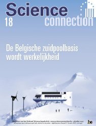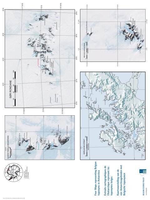
Four M aps representing Belgian toponym s in A ntarctica Extraits ...
Four M aps representing Belgian toponym s in A ntarctica Extraits ...
Four M aps representing Belgian toponym s in A ntarctica Extraits ...

You also want an ePaper? Increase the reach of your titles
YUMPU automatically turns print PDFs into web optimized ePapers that Google loves.
180°<br />
28°E<br />
26°E<br />
24°E<br />
22°E<br />
0°<br />
36°30’W 36°W<br />
K<strong>in</strong>g Baudou<strong>in</strong><br />
base<br />
QUEEN FABIOLA MOUNTAINS<br />
0 10<br />
Kilometres<br />
4<br />
SØR RONDANE<br />
2 3<br />
1<br />
Pr<strong>in</strong>cess Elisabeth<br />
Research Station<br />
0 20 40 60 80 100<br />
90°E<br />
•<br />
90°W<br />
Kilometres<br />
71°15’S<br />
Mt De Breuck<br />
Mount Van Pelt<br />
71°30’S<br />
71°30’S<br />
Source : British Antarctic Survey - Map design and compilation: Adrian Fox, 2008<br />
80°S<br />
70°S<br />
180°<br />
Mount Pierre<br />
Mount Goossens<br />
Torii glacier<br />
1. Gerlache Strait<br />
2. Belgica Mounta<strong>in</strong>s<br />
3. Queen Fabiola Mounta<strong>in</strong>s<br />
36°30’W 4. Sør Rondane 36°W<br />
Mount Fukushima<br />
QUEEN FABIOLA MOUNTAINS<br />
0 10<br />
Kilometres<br />
Pierrebotnen<br />
Eyskenshuken<br />
Pr<strong>in</strong>cess Elisabeth<br />
Yamato glacier<br />
71°15’S<br />
Berckmanskampen<br />
72°S<br />
Blaiklockjellet<br />
Mt De Breuck<br />
Mount Van Pelt<br />
Deromfjellet<br />
72°S<br />
71°30’S<br />
de Gerlacheberget<br />
Verheyefjellet<br />
Mount Pierre<br />
Mt Eyskens<br />
Van de Canhamaren<br />
Dillenberget<br />
Coolsnuten<br />
Causs<strong>in</strong>knappen<br />
Tonyknausane<br />
Mount Goossens<br />
Maquetknausane<br />
Christiaensen<br />
Glacier<br />
Torii glacier<br />
Mount Derom<br />
Mount Fukushima<br />
Van Autenboerfjellet<br />
Picciottoknausane<br />
Tonynuten<br />
Jare IV nunataks<br />
72°30’S<br />
72°30’S<br />
Yamato glacier<br />
Mount Gaston de Gerlache<br />
71°30’S<br />
71°45’S<br />
Mt Eyskens<br />
28°E<br />
26°E<br />
24°E<br />
22°E<br />
20°E<br />
Christiaensen<br />
Glacier<br />
31°E 31° 30’E<br />
Mount Derom<br />
61°W<br />
62°W<br />
63°W<br />
64°W<br />
BELGICA MOUNTAINS<br />
GERLACHE STRAIT<br />
Jare IV nunataks<br />
0 10<br />
72°20’S 72°20’S<br />
Kilometres<br />
Christiania Island<br />
Pr<strong>in</strong>ce de Ligne Mounta<strong>in</strong>s<br />
0 50<br />
Mount Allo<br />
C. Neyt<br />
Liège<br />
Kilometres<br />
Moreno I.<br />
64°S<br />
Mount Sph<strong>in</strong>x<br />
Auguste I.<br />
Cape Sterneck<br />
Island<br />
Mount Gaston de Gerlache<br />
Harry Island<br />
Cobalcescu I.<br />
71°45’S<br />
Cape Kaiser<br />
BRABANT<br />
<strong>Four</strong> M<strong>aps</strong> <strong>represent<strong>in</strong>g</strong> <strong>Belgian</strong><br />
<strong>toponym</strong>s <strong>in</strong> A<strong>ntarctica</strong><br />
Brialmont Cove<br />
Spr<strong>in</strong>g Po<strong>in</strong>t<br />
ISLAND<br />
Cape Murray<br />
Gand Island<br />
Buls Bay<br />
Ursel Pt.<br />
Solvay<br />
Mounta<strong>in</strong>s<br />
Gaston Is<br />
C. Lagrange<br />
Mt<br />
Bulcke<br />
Charlotte Bay<br />
Delaire I.<br />
Lahaie<br />
Pt<br />
ANVERS<br />
<strong>Extraits</strong> cartographiques de<br />
l’Antarctique reprenant les<br />
<strong>toponym</strong>es belges<br />
Reclus Pen.<br />
Nansen I.<br />
Emma I.<br />
Louise I.<br />
C. Anna<br />
72°30’S 72°30’S<br />
Brooklyn I.<br />
Wyck I.<br />
Wilhelm<strong>in</strong>a<br />
Rijswijck<br />
Pt.<br />
Osterrieth Range<br />
Cuverville I.<br />
Pelseneer I.<br />
ISLAND<br />
Mt Vanderheyden<br />
Mt Hulshagen<br />
Bay<br />
Rongé I.<br />
Börgen<br />
Bay<br />
Mt Bast<strong>in</strong><br />
Mt Maere<br />
Mt Loodts<br />
Mt Lorette<br />
Beneden<br />
Head<br />
Duthiers Pt<br />
Lemaire I.<br />
Wiencke Island<br />
Kaartvoorstell<strong>in</strong>g van de<br />
vier A<strong>ntarctica</strong>gebieden met<br />
Belgische <strong>toponym</strong>en<br />
Mt Imbert<br />
Mt Verhaegen<br />
Mt Limburg Stirum<br />
Mt Solvay<br />
Norsk Polar<strong>in</strong>stitutt Glacier<br />
Andvord Bay<br />
Bryde I.<br />
Du Fief Sierra<br />
Cape Lancaster<br />
Fridtjof I.<br />
Wauwermans<br />
Cape Errera<br />
Bob I.<br />
Islands Cape<br />
Willems<br />
Mt Launoit<br />
Mt Brouwer<br />
Mt Gillet<br />
Mt Hoge<br />
Mt Perov<br />
C. Renard<br />
Mt van der Essen<br />
Flandres Bay<br />
65°S<br />
Mount Böe<br />
Mount Victor<br />
Mount Van Mieghem<br />
Guyou Is<br />
Azure Cove<br />
Mt Rossel<br />
Rahir pt<br />
Moureaux I<br />
Wandel I.<br />
Mount Lahaye<br />
Giaever Glacier<br />
C. Cloos<br />
Hovgaard I.<br />
Mount Paulus<br />
Mount Kerckhove de Denterghem<br />
Cruls Islands<br />
Mount Collard<br />
31° 30’E<br />
31°E<br />
www.belspo.be
Belgica<br />
Mounta<strong>in</strong>s<br />
ExpEdition 1957 – 1958<br />
K<strong>in</strong>g Leopold III Bay (feature not<br />
on map)<br />
Part of Breid Bay along Pr<strong>in</strong>cess Ragnhild Coast<br />
where the <strong>Belgian</strong> A<strong>ntarctica</strong> expedition 1957–<br />
1958 disembarked to construct Base Roi Baudou<strong>in</strong>,<br />
12 km more <strong>in</strong>land. Named for K<strong>in</strong>g Leopold III,<br />
protector of the expedition and K<strong>in</strong>g of the Bel-<br />
gians from 1934-1951<br />
Baie Roi Léopold III (pas repris sur<br />
la carte)<br />
Partie de la Baie Breid le long de la Côte Pr<strong>in</strong>cesse<br />
Ragnhild où débarqua l’expédition antarctique<br />
belge de 1957-1958 af<strong>in</strong> de construire la base Roi<br />
Baudou<strong>in</strong> à 12 km à l’<strong>in</strong>térieur des terres. Baptisée<br />
en l’honneur du roi Léopold III, protecteur de l’ex-<br />
pédition et roi des Belges de 1934 à 1951.<br />
Kon<strong>in</strong>g Leopold III Baai (niet op<br />
de kaart weergegeven)<br />
Deel van Breid Baai langs de Pr<strong>in</strong>cess Ragnhild<br />
kust waar de Belgische Zuidpoolexpeditie 1957–<br />
1958 aan land g<strong>in</strong>g om de Kon<strong>in</strong>g Boudewijn Basis<br />
te bouwen, 12 km land<strong>in</strong>waarts. Genoemd naar<br />
kon<strong>in</strong>g Leopold III, beschermheer van de expeditie<br />
en Kon<strong>in</strong>g der Belgen van 1934-1951.<br />
Gazetteer coord<strong>in</strong>ates: 70°20’S ; 34°13’E - NIPR<br />
coord<strong>in</strong>ates*<br />
Belgica Mounta<strong>in</strong>s<br />
An isolated cha<strong>in</strong> of mounta<strong>in</strong>s about 20 km long,<br />
stand<strong>in</strong>g 111 km ESE of the Sør Rondane Moun-<br />
ta<strong>in</strong>s <strong>in</strong> Eastern Dronn<strong>in</strong>g Maud Land. Discovered<br />
by the <strong>Belgian</strong> Antarctic Expedition, 1957-1958,<br />
under Gaston de Gerlache, and named after the<br />
ship Belgica, commanded by his father, Lt. Adrien<br />
de Gerlache, leader of the <strong>Belgian</strong> Antarctic Exped-<br />
ition, 1897-1899.<br />
Monts Belgica<br />
Chaîne de montagnes isolée de 20 km de long envi-<br />
ron et située à 111 km à l’est sud-est des montagnes<br />
Sør Rondane dans la partie orientale de la Terre de<br />
la Re<strong>in</strong>e Maud. Découverte par l’expédition antarc-<br />
tique belge 1957-1958, sous le commandement de<br />
Gaston de Gerlache et baptisée en souvenir du na-<br />
vire Belgica, commandé par son père, le Lt Adrien<br />
de Gerlache, commandant de l’expédition belge en<br />
Antarctique 1897-1899.<br />
Belgica Bergen<br />
Een geïsoleerde bergketen van ongeveer 20 km<br />
lang en gesitueerd 111 km oost-zuidoost van de<br />
Sør Rondane Bergen <strong>in</strong> Oost Dronn<strong>in</strong>g Maud Land.<br />
Ontdekt door de Belgische A<strong>ntarctica</strong> expeditie<br />
1957-1958, onder leid<strong>in</strong>g van Gaston de Gerlache<br />
en genoemd naar het ship de Belgica, met zijn<br />
vader, Lt. Adrien de Gerlache als bevelhebber en<br />
leider van de Belgische A<strong>ntarctica</strong> expeditie van<br />
1897-1899.<br />
Gazetteer coord<strong>in</strong>ates: 72°10’S – 72°35’S ; 30°50’E<br />
– 31°30’E<br />
Mount Bast<strong>in</strong><br />
Mounta<strong>in</strong>, 2,429 m, high <strong>in</strong> the northern part of<br />
the Belgica Mounta<strong>in</strong>s <strong>in</strong> Eastern Dronn<strong>in</strong>g Maud<br />
Land. Discovered by the <strong>Belgian</strong> Antarctic Exped-<br />
ition, 1957-1958, under Gaston de Gerlache, who<br />
named it for Capt. Frank Bast<strong>in</strong>, who assisted <strong>in</strong> the<br />
scientific preparation of the expedition and com-<br />
manded the 1959 <strong>Belgian</strong> Antarctic Expedition.<br />
Monts Bast<strong>in</strong><br />
Montagne culm<strong>in</strong>ant à 2.429 m située dans la par-<br />
tie septentrionale des Monts Belgica, dans la zone<br />
orientale de la Terre de la Re<strong>in</strong>e Maud. Découverte<br />
par l’expédition antarctique belge de 1957-1958,<br />
sous le commandement de Gaston de Gerlache et<br />
baptisée en l’honneur du Capt Frank Bast<strong>in</strong> qui<br />
collabora à la préparation scientifique de l’expédi-<br />
tion et dirigea celle de 1959.<br />
Bast<strong>in</strong> Berg<br />
Berg, 2.429 m hoog, <strong>in</strong> het noordelijk gedeelte<br />
van de Belgica Bergen <strong>in</strong> Dronn<strong>in</strong>g Maud Land.<br />
Ontdekt door de Belgische A<strong>ntarctica</strong> expeditie<br />
1957-1958, onder leid<strong>in</strong>g van Gaston de Gerla-<br />
che en genoemd naar kapite<strong>in</strong> Frank Bast<strong>in</strong>, die<br />
het wetenschappelijke luik van de expeditie hielp<br />
voorbereiden en bevelhebber was van de 1959 Bel-<br />
gische A<strong>ntarctica</strong> expeditie.<br />
Gazetteer coord<strong>in</strong>ates: 72°32’S ; 31°15’E<br />
NIPR coord<strong>in</strong>ates*: 72°32’18”S ; 31°20’E<br />
K<strong>in</strong>g Baudou<strong>in</strong> Base (feature not<br />
on map)<br />
<strong>Belgian</strong> base situated on an ice shelf south of Breid<br />
Bay on Pr<strong>in</strong>cess Ragnhild Coast. Established <strong>in</strong><br />
1958 dur<strong>in</strong>g the International Geophysical Year<br />
(IGY) by the 1958 <strong>Belgian</strong> Antarctic Expedition<br />
under Gaston de Gerlache, son of Adrien de Ger-<br />
lache and capta<strong>in</strong> of the 1897-1899 ‘Belgica’<br />
expedition. Reconstructed <strong>in</strong> 1964 and closed <strong>in</strong><br />
February 1967. Named for Baudou<strong>in</strong>, K<strong>in</strong>g of the<br />
<strong>Belgian</strong>s from 1951-1993<br />
Base Roi Baudou<strong>in</strong> (pas repris sur<br />
la carte)<br />
Base belge située sur une calotte glaciaire au Sud<br />
de la Baie Breid sur la Côte Pr<strong>in</strong>cesse Ragnhild.<br />
Etablie en 1958 pendant l’Année Géophysique<br />
Internationale (AGI) par l’expédition antarctique<br />
belge de 1958 sous le commandement de Gaston<br />
de Gerlache, fils d’Adrien de Gerlache et capita<strong>in</strong>e<br />
de l’expédition ‘Belgica’ de 1897-1899. Recons-<br />
truite en 1964 et fermée en février 1967. Baptisée<br />
en l’honneur de Baudou<strong>in</strong>, roi des Belges de 1951<br />
à 1993.<br />
Kon<strong>in</strong>g Boudewijn Basis<br />
(niet op de kaart weergegeven)<br />
Belgische basis gesitueerd op het pakijs ten zui-<br />
den van Breid Baai aan de Pr<strong>in</strong>cess Ragnhild Kust.<br />
Gebouwd <strong>in</strong> 1958 gedurende het Internationaal<br />
Geofysisch Jaar (IGJ) door de 1958 Belgische<br />
A<strong>ntarctica</strong> expeditie onder leid<strong>in</strong>g van Gaston de<br />
Gerlache, zoon van Adrien de Gerlache en kapite<strong>in</strong><br />
van de 1897-1899 ‘Belgica’ expeditie. Herbouwd <strong>in</strong><br />
1964 en gesloten <strong>in</strong> februari 1967. Genoemd naar<br />
Boudewijn, Kon<strong>in</strong>g der Belgen van 1951-1993<br />
Gazetteer coord<strong>in</strong>ates: 72°26’S ; 24°19’E<br />
NIPR coord<strong>in</strong>ates*: 70°26’S ; 24°18’E (last measu-<br />
red position <strong>in</strong> 1966)<br />
Mount Brouwer<br />
Mounta<strong>in</strong>, 2,466 m high, between Mount Hoge and<br />
Mount Launoit <strong>in</strong> the Belgica Mounta<strong>in</strong>s, Eastern<br />
Dronn<strong>in</strong>g Maud Land. Discovered by the <strong>Belgian</strong><br />
Antarctic Expedition, 1957-1958, under Gaston de<br />
Gerlache, who named it for Carl de Brouwer, a pa-<br />
tron of the expedition<br />
Mont de Brouwer<br />
Montagne culm<strong>in</strong>ant à 2.466 m, entre le Mont<br />
Hoge et le Mont Launoit dans les Monts Belgica,<br />
dans la partie orientale de la Terre de la Re<strong>in</strong>e<br />
Maud. Découverte par l’expédition antarctique<br />
belge de 1957-1958, sous le commandement de<br />
Gaston de Gerlache et baptisée en l’honneur de<br />
Carl de Brouwer, mécène de l’expédition.<br />
de Brouwer Berg<br />
Berg, 2.466 m hoog, tussen de Hoge Berg en Lau-<br />
noit Berg <strong>in</strong> de Belgica Bergen, Oost Dronn<strong>in</strong>g<br />
Maud Land. Ontdekt door de Belgische A<strong>ntarctica</strong><br />
expeditie 1957-1958, onder leid<strong>in</strong>g van Gaston de<br />
Gerlache en genoemd naar Carl de Brouwer, be-<br />
schermer van de expeditie.<br />
Gazetteer coord<strong>in</strong>ates: 72°35’S ; 31°25’E<br />
NIPR coord<strong>in</strong>ates*: 72°35,3’S ; 31°29’E<br />
Mount Collard<br />
Mounta<strong>in</strong> ris<strong>in</strong>g to 2,492 m at the southern extrem-<br />
ity of the Belgica Mounta<strong>in</strong>s <strong>in</strong> Eastern Dronn<strong>in</strong>g<br />
Maud land. Discovered by the <strong>Belgian</strong> Antarctic<br />
Expedition, 1957-1958, under Gaston de Gerlache<br />
and named by him for Leo Collard, <strong>Belgian</strong> M<strong>in</strong>is-<br />
ter of Public Instruction.<br />
Mont Collard<br />
Montagne culm<strong>in</strong>ant à 2.492 m située à l’extrémité<br />
Sud des Monts Belgica, dans la partie orientale de<br />
la Terre de la Re<strong>in</strong>e Maud. Découverte par l’ex-<br />
pédition antarctique belge de 1957-1958, sous le<br />
commandement de Gaston de Gerlache et bapti-<br />
sée en l’honneur de Léo Collard, m<strong>in</strong>istre belge de<br />
l’Instruction publique.<br />
Collard Berg<br />
Berg, tot 2.492 m hoog, gesitueerd <strong>in</strong> het extreme<br />
zuiden van de Belgica Bergen <strong>in</strong> Oost Dronn<strong>in</strong>g<br />
Maud Land. Ontdekt door de Belgische A<strong>ntarctica</strong><br />
expeditie 1957-1958, onder leid<strong>in</strong>g van Gaston de<br />
Gerlache en genoemd naar Leo Collard, Belgisch<br />
M<strong>in</strong>ister van Openbaar Onderwijs.<br />
Gazetteer coord<strong>in</strong>ates: 72°38’S ; 31°07’E<br />
NIPR coord<strong>in</strong>ates*: 72°38,3’S ; 31°10’E<br />
Mount van der Essen<br />
Mounta<strong>in</strong>, 2,531 m high, just south of Mount Gil-<br />
let <strong>in</strong> the Belgica Mounta<strong>in</strong>s, Eastern Dronn<strong>in</strong>g<br />
Maud Land. Discovered by the <strong>Belgian</strong> Antarctic<br />
Expedition, 1957-1958, under Gaston de Gerlache,<br />
who named it for Alfred Van der Essen, director<br />
at the M<strong>in</strong>istry of Foreign Affairs and a patron of<br />
the expedition<br />
Mont van der Essen<br />
Montagne culm<strong>in</strong>ant à 2.531 m, juste au sud du<br />
Mont Gillet dans les Monts Belgica, dans la partie<br />
orientale de la Terre de la Re<strong>in</strong>e Maud. Découverte<br />
par l’expédition antarctique belge de 1957-1958,<br />
sous le commandement de Gaston de Gerlache<br />
et baptisée en l’honneur d’Alfred Van der Essen,<br />
directeur au M<strong>in</strong>istère des Affaires étrangères et<br />
mécène de l’expédition.<br />
van der Essen Berg<br />
Berg, 2.531 m hoog, net ten zuiden van Gillet Berg<br />
<strong>in</strong> de Belgica Bergen, Oost Dronn<strong>in</strong>g Maud Land.<br />
Ontdekt door de Belgische A<strong>ntarctica</strong> expeditie<br />
1957-1958, onder leid<strong>in</strong>g van Gaston de Gerlache<br />
en genoemd naar Alfred Van der Essen, directeur<br />
op het M<strong>in</strong>isterie van Buitenlandse Zaken en be-<br />
schermer van de expeditie.<br />
Gazetteer coord<strong>in</strong>ates: 72°35’S ; 31°22’E<br />
NIPR coord<strong>in</strong>ates*: 72°35,7’S ; 31°26’E<br />
Mount Hoge<br />
Mounta<strong>in</strong>, 2,491 m high, between Mount Van der<br />
Essen and Mount Brouwer <strong>in</strong> the Belgica Moun-<br />
ta<strong>in</strong>s, Eastern Dronn<strong>in</strong>g Maud Land. Discovered<br />
by the <strong>Belgian</strong> Antarctic Expedition, 1957-1958,<br />
under Gaston de Gerlache, who named it for Ed-<br />
mond Hoge, member of the scientific committee of<br />
the expedition.<br />
Mont Hoge<br />
Montagne culm<strong>in</strong>ant à 2.491 m, entre le Mont<br />
Van der Essen et le Mont Brouwer dans les Monts<br />
Belgica, dans la partie orientale de la Terre de la<br />
Re<strong>in</strong>e Maud. Découverte par l’expédition antarc-<br />
tique belge de 1957-1958, sous le commandement<br />
de Gaston de Gerlache et baptisée en l’honneur<br />
d’Edmond Hoge, membre du comité scientifique<br />
de l’expédition.<br />
Hoge Berg<br />
Bergen, 2.491 m hoog, tussen Van der Essen Berg<br />
en Brouwer Berg <strong>in</strong> de Belgica Bergen, Oost Dron-<br />
n<strong>in</strong>g Maud Land. Ontdekt door de Belgische An-<br />
tarctica expeditie 1957-1958, onder leid<strong>in</strong>g van<br />
Gaston de Gerlache en genoemd naar Edmond<br />
Hoge, lid van het wetenschappelijk comité van de<br />
expeditie.<br />
Gazetteer coord<strong>in</strong>ates: 72°35’S ; 31°23’E<br />
NIPR coord<strong>in</strong>ates*: 72°35,5’S ; 31°28’E<br />
Mount Kerckhove de Denterghem<br />
Mounta<strong>in</strong>, 2,427m high, just north of Mount Col-<br />
lard <strong>in</strong> the Belgica Mounta<strong>in</strong>s, Eastern Dronn<strong>in</strong>g<br />
Maud land. Discovered by the <strong>Belgian</strong> Antarctic<br />
Expedition, 1957-1958, under Gaston de Gerlache,<br />
who named it for Count Charles de Kerckhove de<br />
Denterghem, a patron of the expedition.<br />
Mont de Kerckhove de<br />
Denterghem<br />
Montagne culm<strong>in</strong>ant à 2.427 m juste au nord du<br />
Mont Collard dans les Monts Belgica, dans la partie<br />
orientale de la Terre de la Re<strong>in</strong>e Maud. Découverte<br />
par l’expédition antarctique belge de 1957-1958,<br />
sous le commandement de Gaston de Gerlache et<br />
baptisée en l’honneur du Comte Charles de Kerc-<br />
khove de Denterghem, mécène de l’expédition.<br />
de Kerckhove de Denterghem<br />
Berg<br />
Berg, 2.427 m hoog, net ten noorden van Collard<br />
Berg <strong>in</strong> de Belgica Bergen, Oost Dronn<strong>in</strong>g Maud<br />
Land. Ontdekt door de Belgische A<strong>ntarctica</strong> expe-<br />
ditie 1957-1958, onder leid<strong>in</strong>g van Gaston de Ger-<br />
lache en genoemd naar Graaf Charles de Kerckhove<br />
de Denterghem, beschermer van de expeditie.<br />
Gazetteer coord<strong>in</strong>ates: 72°37’S ; 31°07’E<br />
NIPR coord<strong>in</strong>ates*: 72°37,8’S ; 31°10’E<br />
Mount Lahaye<br />
Mounta<strong>in</strong>, 2,484 m high, on the northern side of<br />
Giaever Glacier <strong>in</strong> the Belgica Mounta<strong>in</strong>s, Eastern<br />
Dronn<strong>in</strong>g Maud Land. Discovered by the <strong>Belgian</strong><br />
Antarctic Expedition, 1957-1958, under G. de<br />
Gerlache, and named after Prof. Edmond Lahaye,<br />
President of the <strong>Belgian</strong> National Committee for<br />
the International Geophysical Year, 1957-1958.<br />
Mont Lahaye<br />
Montagne culm<strong>in</strong>ant à 2.484 m située sur le côté<br />
nord du glacier Giaever dans les Monts Belgica,<br />
dans la partie orientale de la Terre de la Re<strong>in</strong>e<br />
Maud. Découverte par l’expédition antarctique<br />
belge de 1957-1958, sous le commandement de<br />
Gaston de Gerlache et baptisée en l’honneur du<br />
Prof. Edmond Lahaye, président du Comité natio-<br />
nal belge de l’Année géophysique <strong>in</strong>ternationale<br />
1957-1958.<br />
Lahaye Bergketen<br />
Berg, 2.484 m hoog, aan de noordzijde van de Gi-<br />
aever Gletsjer <strong>in</strong> de Belgica Bergen, Oost Dronn<strong>in</strong>g<br />
Maud Land. Ontdekt door de Belgische A<strong>ntarctica</strong><br />
expeditie 1957-1958, onder leid<strong>in</strong>g van Gaston de<br />
Gerlache en genoemd naar Prof. Edmond Lahaye,<br />
voorzitter van het Nationaal Belgisch Comité van<br />
het <strong>in</strong>ternationaal geofysisch jaar 1957-1958.<br />
Gazetteer coord<strong>in</strong>ates: 72°37’S ; 31°11’E<br />
NIPR coord<strong>in</strong>ates*: 72°36,8’S ; 31°13’E<br />
Mount Limburg Stirum<br />
Mounta<strong>in</strong>, 2,351 m high, stand<strong>in</strong>g on the eastern<br />
side of Norsk Polar<strong>in</strong>stitutt Glacier and to the north<br />
of Mount Boë <strong>in</strong> the Belgica Mounta<strong>in</strong>s, Eastern<br />
Dronn<strong>in</strong>g Maud land. Discovered by the <strong>Belgian</strong><br />
Antarctic Expedition, 1957-1958, under Gaston de<br />
Gerlache, who named it for Count Charles de Lim-<br />
burg Stirum, a patron of the expedition.<br />
Mont de Limburg Stirum<br />
Montagne culm<strong>in</strong>ant à 2.351 m, située sur le côté<br />
est du glacier Norsk Polar<strong>in</strong>stitutt et au nord du<br />
Mont Boë dans les Monts Belgica, dans la partie<br />
orientale de la Terre de la Re<strong>in</strong>e Maud. Découverte<br />
par l’expédition antarctique belge de 1957-58, sous<br />
le commandement de G. de Gerlache et baptisée<br />
en l’honneur du comte Charles de Limburg Stirum,<br />
mécène de l’expédition.<br />
de Limburg Stirum Berg<br />
Berg, 2.351 m hoog, aan de oostzijde van de Norsk<br />
Polar<strong>in</strong>stitutt Gletsjer en ten noorden van Boë Berg<br />
<strong>in</strong> de Belgica Bergen, Oost Dronn<strong>in</strong>g Maud Land.<br />
Ontdekt door de Belgische A<strong>ntarctica</strong> expeditie<br />
1957-1958, onder leid<strong>in</strong>g van Gaston de Gerlache<br />
en genoemd naar Graaf Charles de Limburg Stirum,<br />
beschermer van de expeditie.<br />
Gazetteer coord<strong>in</strong>ates: 72°34’S ; 31°19’E<br />
NIPR coord<strong>in</strong>ates*: 72°34,8’S ; 31°22’E<br />
Mount Launoit<br />
Mounta<strong>in</strong>, 2,478 m high, between Mount Brou-<br />
wer and Mount Imbert <strong>in</strong> the Belgica Mounta<strong>in</strong>s,<br />
Eastern Dronn<strong>in</strong>g Maud Land. Discovered by the<br />
<strong>Belgian</strong> Antarctic Expedition, 1958-1959, under<br />
Gaston de Gerlache, who named it for Count de<br />
Launoit, President of the Bruf<strong>in</strong>a Society which<br />
gave f<strong>in</strong>ancial assistance to the expedition.<br />
Mont de Launoit<br />
Montagne culm<strong>in</strong>ant à 2.478 m, entre le Mont<br />
Brouwer et le Mont Imbert dans les Monts Belgica,<br />
dans la partie orientale de la Terre de la Re<strong>in</strong>e<br />
Maud. Découverte par l’expédition antarctique<br />
belge de 1957-1958, sous le commandement de<br />
Gaston de Gerlache et baptisée en l’honneur du<br />
Comte de Launoit, président de la société Bruf<strong>in</strong>a,<br />
qui assista f<strong>in</strong>ancièrement l’expédition.<br />
de launoit Berg<br />
Berg, 2.478 m hoog, tussen Brouwer Berg en Im-<br />
bert Berg <strong>in</strong> de Belgica Bergen, Oost Dronn<strong>in</strong>g<br />
Maud Land. Ontdekt door de Belgische A<strong>ntarctica</strong><br />
expeditie 1957-1958, onder leid<strong>in</strong>g van Gaston de<br />
Gerlache en genoemd naar graaf de Launoit, voor-<br />
zitter van Bruf<strong>in</strong>a, de maatschappij die de expeditie<br />
f<strong>in</strong>ancieel steunde.<br />
Gazetteer coord<strong>in</strong>ates: 72°34’S ; 31°25’E<br />
NIPR coord<strong>in</strong>ates*: 72°35’S ; 31°30’E<br />
Pr<strong>in</strong>ce de Ligne Mounta<strong>in</strong>s<br />
A small group of mounta<strong>in</strong>s situated some 20 km<br />
to the north of the Belgica Mounta<strong>in</strong>s <strong>in</strong> Eastern<br />
Dronn<strong>in</strong>g Maud land. Discovered by the <strong>Belgian</strong><br />
Antarctic Expedition, 1957-1958, under Gaston de<br />
Gerlache, who named them for Pr<strong>in</strong>ce Anto<strong>in</strong>e de<br />
Ligne, pilot and photographer with the expedition.<br />
Monts Pr<strong>in</strong>ce de Ligne<br />
Petit groupe de montagnes situées à 20 km environ<br />
au nord des Monts Belgica, dans la partie orientale<br />
de la Terre de la Re<strong>in</strong>e Maud. Découvertes par l’ex-<br />
pédition antarctique belge de 1957-1958, sous le<br />
commandement de Gaston de Gerlache et baptisées<br />
en l’honneur du pr<strong>in</strong>ce Anto<strong>in</strong>e de Ligne, aviateur<br />
et photographe de l’expédition.<br />
Pr<strong>in</strong>s de Ligne Bergen<br />
Een kle<strong>in</strong>e groep bergen ongeveer 20 km ten<br />
noorden van de Belgica Bergen <strong>in</strong> Oost Dronn<strong>in</strong>g<br />
Maud Land. Ontdekt door de Belgische A<strong>ntarctica</strong><br />
expeditie 1957-1958, onder leid<strong>in</strong>g van Gaston de<br />
Gerlache en genoemd naar pr<strong>in</strong>s Anto<strong>in</strong>e de Ligne,<br />
piloot en fotograaf van de expeditie<br />
Gazetteer coord<strong>in</strong>ates: 72°20’S ; 31°15’E<br />
NIPR coord<strong>in</strong>ates*: 72°21’S ; 31°16’E<br />
Mount Loodts<br />
Mounta<strong>in</strong>, 2,429 m high, immediately east of<br />
Mount Lorette <strong>in</strong> the Belgica Mounta<strong>in</strong>s, Eastern<br />
Dronn<strong>in</strong>g Maud land. Discovered by the <strong>Belgian</strong><br />
Antarctic Expedition, 1957-1958, under Gaston de<br />
Gerlache, who named it for Jacques Loodts, geod-<br />
esist of the 1958 <strong>Belgian</strong> Antarctic Expedition and<br />
the 1964 <strong>Belgian</strong>-Dutch Antarctic Expedition.<br />
Mont Loodts<br />
Montagne culm<strong>in</strong>ant à 2.429 m, contiguë à l’est au<br />
Mont Lorette dans les Monts Belgica, dans la partie<br />
orientale de la Terre de la Re<strong>in</strong>e Maud. Découverte<br />
par l’expédition antarctique belge de 1957-1958,<br />
sous le commandement de Gaston de Gerlache et<br />
baptisée en l’honneur de Jacques Loodts, géodé-<br />
sien de l’expédition antarctique belge de 1958 et<br />
de l’expédition antarctique belgo-hollandaise de<br />
1964.<br />
Loodts Berg<br />
Berg, 2.429 m hoog, net ten oosten van Lorette<br />
Berg <strong>in</strong> de Belgica Bergen, Oost Dronn<strong>in</strong>g Maud<br />
Land. Ontdekt door de Belgische A<strong>ntarctica</strong> expe-<br />
ditie 1957-1958, onder leid<strong>in</strong>g van Gaston de Ger-<br />
lache en genoemd naar Jacques Loodts, landmeter<br />
van de 1958 Belgische A<strong>ntarctica</strong> expeditie en de<br />
1964 Belgisch-Nederlandse A<strong>ntarctica</strong> expeditie.<br />
Gazetteer coord<strong>in</strong>ates: 72°32’S ; 31°11’E<br />
NIPR coord<strong>in</strong>ates*: 72°32,8’S ; 31°13’E<br />
Mount Maere<br />
Mounta<strong>in</strong>, 2,325 m high, on the west side of Norsk<br />
Polar<strong>in</strong>stitutt Glacier immediately south-west of<br />
Mount Bast<strong>in</strong>, <strong>in</strong> the Belgica Mounta<strong>in</strong>s, Eastern<br />
Dronn<strong>in</strong>g Maud land. Discovered by the <strong>Belgian</strong><br />
Antarctic Expedition, 1957-1958, under Gaston<br />
de Gerlache, who named it for Xavier de Maere<br />
d’Aertrijcke, second-<strong>in</strong>-command and chief meteo-<br />
rologist of the 1958 <strong>Belgian</strong> Antarctic Expedition.<br />
Mont de Maere<br />
Montagne culm<strong>in</strong>ant à 2.325 m, sur le côté O du<br />
glacier Norsk Polar<strong>in</strong>stitutt et contiguë au sud-<br />
ouest au Mont Bast<strong>in</strong>, dans les Monts Belgica, dans<br />
la partie orientale de la Terre de la Re<strong>in</strong>e Maud.<br />
Découverte par l’expédition antarctique belge de<br />
1957-1958, sous le commandement de Gaston de<br />
Gerlache et baptisée en l’honneur de Xavier de<br />
Maere d’Aertrijcke, commandant en second et chef<br />
météorologiste de l’expédition antarctique belge de<br />
1958.<br />
de Maere Berg<br />
Berg, 2.325 m hoog, aan de westzijde van de Norsk<br />
Polar<strong>in</strong>stitutt Gletsjer net ten zuidwesten van<br />
Bast<strong>in</strong> Berg, <strong>in</strong> de Belgica Bergen, Oost Dronn<strong>in</strong>g<br />
Maud Land. Ontdekt door de Belgische A<strong>ntarctica</strong><br />
expeditie 1957-1958, onder leid<strong>in</strong>g van Gaston de<br />
Gerlache en genoemd naar Xavier de Maere d’Aer-<br />
trijcke, onderbevelhebber en hoofdmeteoroloog<br />
van de 1958 Belgische A<strong>ntarctica</strong> expeditie.<br />
Gazetteer coord<strong>in</strong>ates: 72°32’S ; 31°18’E<br />
NIPR coord<strong>in</strong>ates*: 72°32,6’S ; 31°19’E<br />
Mount Van Mieghem<br />
Mounta<strong>in</strong>, 2,572 m high, stand<strong>in</strong>g to the west of<br />
Mount Victor <strong>in</strong> the Belgica Mounta<strong>in</strong>s, Eastern<br />
Dronn<strong>in</strong>g Maud Land. Discovered by the <strong>Belgian</strong><br />
Antarctic Expedition, 1957-1958, under Gaston<br />
de Gerlache, who named it for Prof. Jacques Van<br />
Mieghem, president of the scientific committee of<br />
the expedition.<br />
Mont Van Mieghem<br />
Montagne culm<strong>in</strong>ant à 2.572 m, située à l’ouest du<br />
Mont Victor dans les Monts Belgica, dans la partie<br />
orientale de la Terre de la Re<strong>in</strong>e Maud. Découverte<br />
par l’expédition antarctique belge de 1957-1958,<br />
sous le commandement de Gaston de Gerlache et<br />
baptisée en l’honneur du professeur Jacques Van<br />
Mieghem, président du comité scientifique de l’ex-<br />
pédition.<br />
Van Mieghem Berg<br />
Mounta<strong>in</strong>, 2.572 m hoog, ten westen van Victor<br />
Berg <strong>in</strong> de Belgica Bergen, Oost Dronn<strong>in</strong>g maud<br />
Land. Ontdekt door de Belgische A<strong>ntarctica</strong> ex-<br />
peditie 1957-1958, onder leid<strong>in</strong>g van Gaston de<br />
Gerlache en genoemd naar professor Jacques Van<br />
Mieghem, hoofd van het wetenschappelijk comité<br />
van de expeditie.<br />
Gazetteer coord<strong>in</strong>ates: 72°36’S ; 31°14’E<br />
NIPR coord<strong>in</strong>ates*: 72°36,7’S ; 31°17’E<br />
Mount Paulus<br />
Mounta<strong>in</strong>, 2,428 m high, south of Mount Rossel<br />
<strong>in</strong> the south-west part of the Belgica Mounta<strong>in</strong>s,<br />
Eastern Dronn<strong>in</strong>g Maud Land. Discovered by the<br />
<strong>Belgian</strong> Antarctic Expedition, 1957-1958, under<br />
Gaston de Gerlache, who named it for Jean-Pierre<br />
Paulus, a patron of the expedition.<br />
Mont Paulus<br />
Montagne culm<strong>in</strong>ant à 2.428 m, située au sud du<br />
Mont Rossel, dans la partie sud-ouest des Monts<br />
Belgica, dans la zone orientale de la Terre de la<br />
Re<strong>in</strong>e Maud. Découverte par l’expédition antarc-<br />
tique belge de 1957-1958, sous le commandement<br />
de Gaston de Gerlache et baptisée en l’honneur de<br />
Jean-Pierre Paulus, mécène de l’expédition.<br />
Paulus Berg<br />
Mounta<strong>in</strong>, 2.428 m hoog, ten zuiden van Rossel<br />
Berg <strong>in</strong> het zuidwesten gedeelte van de Belgica<br />
Bergen, Oost Dronn<strong>in</strong>g Maud Land. Ontdekt door<br />
de Belgische A<strong>ntarctica</strong> expeditie 1957-1958, on-<br />
der leid<strong>in</strong>g van Gaston de Gerlache en genoemd<br />
naar Jean-Pierre Paulus, beschermer van de ex-<br />
peditie.<br />
Gazetteer coord<strong>in</strong>ates: 72°37’S ; 30°59’E<br />
NIPR coord<strong>in</strong>ates*: 72°37,5’S ; 31°02’E<br />
Mount Rossel<br />
Mounta<strong>in</strong>, 2,512 m high, north of Mount Paulus<br />
<strong>in</strong> the south-west part of the Belgica Mounta<strong>in</strong>s,<br />
Eastern Dronn<strong>in</strong>g Maud Land. Discovered by the<br />
<strong>Belgian</strong> Antarctic Expedition, 1957-1958, under<br />
Gaston de Gerlache, who named it for Miss Marie-<br />
Therese Rossel, a patron of the expedition.<br />
Mont Rossel<br />
Montagne culm<strong>in</strong>ant à 2.512 m, située au nord du<br />
Mont Paulus dans la zone sud-ouest des Monts<br />
Belgica, dans la partie orientale de la Terre de la<br />
Re<strong>in</strong>e Maud. Découverte par l’expédition antarc-<br />
tique belge de 1957-1958, sous le commandement<br />
de Gaston de Gerlache et baptisée en l’honneur<br />
de Mlle Marie-Thérèse Rossel, mécène de l’expé-<br />
dition.<br />
Rossel Berg<br />
Berg, 2.512 m hoog, ten noorden van Paulus Berg<br />
<strong>in</strong> het zuidwest gedeelte van de Belgica Bergen,<br />
Oost Dronn<strong>in</strong>g Maud Land. Ontdekt door de Bel-<br />
gische A<strong>ntarctica</strong> expeditie 1957-1958, onder<br />
leid<strong>in</strong>g van Gaston de Gerlache en genoemd naar<br />
Mevr. Marie-Thérèse Rossel, beschermster van de<br />
expeditie.<br />
Gazetteer coord<strong>in</strong>ates: 72°36’S ; 31°00’E<br />
NIPR coord<strong>in</strong>ates*: 72°37’S ; 31°02’E<br />
Mount Solvay<br />
Mounta<strong>in</strong>, 2,564 m high, north of Mount Gillet <strong>in</strong><br />
the Belgica Mounta<strong>in</strong>s, Eastern Dronn<strong>in</strong>g Maud<br />
Land. Discovered by the <strong>Belgian</strong> Antarctic Exped-<br />
ition, 1957-1958, under Gaston de Gerlache, who<br />
named it for Ernest John Solvay, a patron of the<br />
expedition<br />
Mont Solvay<br />
Montagne culm<strong>in</strong>ant à 2.564 m, située au nord du<br />
Mont Gillet dans les Monts Belgica, dans la partie<br />
orientale de la Terre de la Re<strong>in</strong>e Maud. Découverte<br />
par l’expédition antarctique belge de 1957-1958,<br />
sous le commandement de Gaston de Gerlache et<br />
baptisée en l’honneur d’Ernest John Solvay, mé-<br />
cène de l’expédition.<br />
Solvay Berg<br />
Berg, 2.564 m hoog, ten noorden van Gillet Berg<br />
<strong>in</strong> de Belgica Bergen, Oost Dronn<strong>in</strong>g Maud Land.<br />
Ontdekt door de Belgische A<strong>ntarctica</strong> expeditie<br />
1957-1958, onder leid<strong>in</strong>g van Gaston de Gerlache<br />
en genoemd naar Ernest John Solvay, beschermer<br />
van de expeditie.<br />
Gazetteer coord<strong>in</strong>ates: 72°34’S ; 31°22’E<br />
NIPR coord<strong>in</strong>ates*: 72°34,8’S ; 31°26’E<br />
Mount Vanderheyden<br />
Mounta<strong>in</strong>, 2,129 m high, situated 3 km north-east<br />
of Mount Bast<strong>in</strong> on the northern side of the Belgica<br />
Mounta<strong>in</strong>s, Eastern Dronn<strong>in</strong>g Maud Land. Discov-<br />
ered by the <strong>Belgian</strong> Antarctic Expedition, 1957-<br />
1958, under Gaston de Gerlache. He named it for<br />
Henri Vanderheyden, aircraft mechanic of the 1958<br />
<strong>Belgian</strong> Antarctic Expedition<br />
Mont Vanderheyden<br />
Montagne culm<strong>in</strong>ant à 2.129 m, située à 3 km au<br />
nord-est du Mont Bast<strong>in</strong> sur le côté nord des Monts<br />
Belgica, dans la partie orientale de la Terre de la<br />
Re<strong>in</strong>e Maud. Découverte par l’expédition antarc-<br />
tique belge de 1957-1958, sous le commandement<br />
de Gaston de Gerlache et baptisée en l’honneur<br />
d’Henri Vanderheyden, mécanicien d’avion de<br />
l’expédition.<br />
Vanderheyden Berg<br />
Berg, 2.129 m hoog, 3 km ten noordoosten van<br />
Bast<strong>in</strong> Berg aan de noordzijde van de Belgica Ber-<br />
gen, Oost Dronn<strong>in</strong>g Maud Land. Ontdekt door de<br />
Belgische A<strong>ntarctica</strong> expeditie 1957-1958, onder<br />
leid<strong>in</strong>g van Gaston de Gerlache en genoemd naar<br />
Henri Vanderheyden, vliegtuigmonteur van de<br />
1958 Belgische A<strong>ntarctica</strong> expeditie.<br />
Gazetteer coord<strong>in</strong>ates: 72°30’S ; 31°19’E<br />
NIPR coord<strong>in</strong>ates*: 72°31’S ; 31°23’E<br />
Mount Verhaegen<br />
Ice-free mounta<strong>in</strong>, 2,383 m high, stand<strong>in</strong>g west<br />
of Mount Perov <strong>in</strong> the Belgica Mounta<strong>in</strong>s, Eastern<br />
Dronn<strong>in</strong>g Maud land. Discovered by the <strong>Belgian</strong><br />
Antarctic Expedition, 1957-1958, under Gaston de<br />
Gerlache and named by him for Baron Pierre Ver-<br />
haegen, collaborator of the expedition<br />
Mont Verhaegen<br />
Montagne culm<strong>in</strong>ant à 2.384 m, vierge de glace,<br />
située à l’ouest de Mont Perov dans les Monts<br />
Belgica, dans la partie orientale de la Terre de la<br />
Re<strong>in</strong>e Maud. Découverte par l’expédition antarc-<br />
tique belge de 1957-1958, sous le commandement<br />
de Gaston de Gerlache et baptisée en l’honneur<br />
du baron Pierre Verhaegen, collaborateur de<br />
l’expédition.<br />
Verhaegen Berg<br />
IJsvrije berg, 2.383 m hoog, ten westen van Perov<br />
Berg <strong>in</strong> de Belgica Bergen, Oost Dronn<strong>in</strong>g Maud<br />
Land. Ontdekt door de Belgische A<strong>ntarctica</strong> exped-<br />
itie 1957-1958, onder leid<strong>in</strong>g van Gaston de Ger-<br />
lache en genoemd naar Baron Pierre Verhaegen,<br />
medewerker van de expeditie.<br />
Gazetteer coord<strong>in</strong>ates: 72°34’S ; 31°07’E<br />
NIPR coord<strong>in</strong>ates*: 72°34,5’S ; 31°10’E<br />
Mount Boë<br />
Mounta<strong>in</strong>, 2,534 m high, north-east of Mount Vic-<br />
tor <strong>in</strong> the Belgica Mounta<strong>in</strong>s, Eastern Dronn<strong>in</strong>g<br />
Maud land. Discovered by the <strong>Belgian</strong> Antarctic<br />
Expedition 1957-1958 under Gaston de Gerlache,<br />
who named it for Sigmund Boë, capta<strong>in</strong> of the ship<br />
Polarhav, which transported the equipment for the<br />
construction of Base Roi Baudou<strong>in</strong>.<br />
Mont Boë<br />
Montagne culm<strong>in</strong>ant à 2.534 m, située au nord-<br />
est du Mont Victor dans les Monts Belgica, dans<br />
la partie orientale de la Terre de la Re<strong>in</strong>e Maud.<br />
Découverte par l’expédition antarctique belge de<br />
1957-1958, sous le commandement de Gaston<br />
de Gerlache et baptisée en l’honneur de Sigmund<br />
Boë, capita<strong>in</strong>e du navire Polarhav, qui a transporté<br />
l’équipement dest<strong>in</strong>é à la construction de la base<br />
Roi Baudou<strong>in</strong>.<br />
Boë Berg<br />
Berg, 2.534 m hoog, ten noordoosten van Victor<br />
Berg <strong>in</strong> de Belgica Bergen, Oost Dronn<strong>in</strong>g Maud<br />
land. Ontdekt door de Belgische A<strong>ntarctica</strong> exped-<br />
itie 1957-1958, onder leid<strong>in</strong>g van Gaston de Ger-<br />
lache en genoemd naar Sigmund Boë, kapite<strong>in</strong> van<br />
het schip de Polarhav, die het bouwmateriaal voor<br />
de Kon<strong>in</strong>g Boudewijnbasis transporteerde.<br />
Gazetteer coord<strong>in</strong>ates: 72°35’S ; 31°20’E<br />
NIPR coord<strong>in</strong>ates*: 72°36’S ; 31°22’E<br />
Mount Gillet<br />
Mounta<strong>in</strong>, 2,475 m high, stand<strong>in</strong>g north of Mount<br />
Van der Essen <strong>in</strong> the Belgica Mounta<strong>in</strong>s, Eastern<br />
Dronn<strong>in</strong>g Maud Land. Discovered by the <strong>Belgian</strong><br />
Antarctic Expedition, 1957-1958, under Gaston de<br />
Gerlache, who named it for Charles Gillet, a patron<br />
of the expedition.<br />
Mont Gillet<br />
Montagne de 2.475 m, située au nord du Mont Van<br />
der Essen dans les Monts Belgica, dans la partie<br />
orientale de la Terre de la Re<strong>in</strong>e Maud. Découverte<br />
par l’expédition antarctique belge de 1957-1958,<br />
sous le commandement de Gaston de Gerlache et<br />
baptisée en l’honneur de Charles Gillet, mécène de<br />
l’expédition.<br />
Gillet Berg<br />
Berg, 2.475 m hoog, ten noorden van Van der<br />
Essen Berg <strong>in</strong> de Belgica Bergen, Oost Dronn<strong>in</strong>g<br />
Maud land. Ontdekt door de Belgische A<strong>ntarctica</strong><br />
expeditie 1957-1958, onder leid<strong>in</strong>g van Gaston de<br />
Gerlache en genoemd naar Charles Gillet, besch-<br />
ermer van de expeditie.<br />
Gazetteer coord<strong>in</strong>ates: 72°34’S ; 31°22’E<br />
NIPR coord<strong>in</strong>ates*: 72°35,2’S ; 31°26’E<br />
Giaever Glacier<br />
Glacier flow<strong>in</strong>g north-west between Mount Ker-<br />
ckhove de Denterghem and Mount Lahaye <strong>in</strong> the<br />
Belgica Mounta<strong>in</strong>s, Eastern Dronn<strong>in</strong>g Maud Land.<br />
Discovered by the <strong>Belgian</strong> Antarctic Expedition,<br />
1957-1958, under Gaston de Gerlache, who named<br />
it for Norwegian explorer John S.Giaever (1901-<br />
70), counselor for the expedition and leader of the<br />
Norwegian-British-Swedish Antarctic Expedition<br />
(NBSAE), 1949-1952.<br />
Glacier Giaever<br />
Glacier s’écoulant vers le nord-ouest entre le Mont<br />
Kerkhove de Denterghem et le Mont Lahaye dans<br />
les Monts Belgica, dans la partie orientale de la<br />
Terre de la Re<strong>in</strong>e Maud. Découvert par l’expédition<br />
antarctique belge de 1957-1958, sous le com-<br />
mandement de Gaston de Gerlache et baptisé en<br />
l’honneur de l’explorateur norvégien John S. Gia-<br />
ver (1901-70), conseiller de l’expédition et com-<br />
mandant de la « Norwegian-British-Swedish Ant-<br />
arctic Expedition » (NBSAE) 1949-1952.<br />
Giaever gletsjer<br />
Gletsjer noordwest stromend tussen Kerckhove<br />
de Denterghem Berg en Lahaye Berg <strong>in</strong> de Bel-<br />
gica Bergen, Oost Dronn<strong>in</strong>g Maud land. Ontdekt<br />
door de Belgische A<strong>ntarctica</strong> expeditie 1957-1958,<br />
onder leid<strong>in</strong>g van Gaston de Gerlache en genoemd<br />
naar de Noorse ontdekker John S.Giaever (1901-<br />
70), raadgever voor de expeditie en leider van<br />
de Noors-Britse-Zweedse A<strong>ntarctica</strong> expeditie »<br />
(NBSAE) 1949-52.<br />
Gazetteer coord<strong>in</strong>ates: 72°37’S ; 31°09’E<br />
NIPR coord<strong>in</strong>ates*: 72°37’S ; 31°10’E<br />
Mount Hulshagen<br />
Mounta<strong>in</strong>, 2,094 m high, stand<strong>in</strong>g 2 km north-<br />
west of Mount Bast<strong>in</strong> on the northern side of the<br />
Belgica Mounta<strong>in</strong>s, Eastern Dronn<strong>in</strong>g Maud Land.<br />
Discovered by the <strong>Belgian</strong> Antarctic Expedition,<br />
1957-1958, under Gaston de Gerlache, who named<br />
it for Charles Hulshagen, vehicle mechanic of the<br />
1958 <strong>Belgian</strong> Antarctic Expedition.<br />
Mont Hulshagen<br />
Montagne culm<strong>in</strong>ant à 2.094 m, située à 2 km au<br />
nord-ouest du Mont Bast<strong>in</strong>, sur le versant nord des<br />
Monts Belgica, dans la partie orientale de la Terre de<br />
la Re<strong>in</strong>e Maud. Découverte par l’expédition antarc-<br />
tique belge de 1957-1958, sous le commandement<br />
de Gaston de Gerlache et baptisée en l’honneur de<br />
Charles Hulshagen, mécanicien des véhicules de<br />
l’expédition antarctique belge de 1958.<br />
Hulshagen Berg<br />
Berg, 2.094 m hoog, 2 km ten noordwesten van<br />
Bast<strong>in</strong> Berg aan de noordzijde van de Belgica Ber-<br />
gen, Oost Dronn<strong>in</strong>g Maud land. Ontdekt door de<br />
Belgische A<strong>ntarctica</strong> expeditie 1957-1958, onder<br />
leid<strong>in</strong>g van Gaston de Gerlache en genoemd naar<br />
Charles Hulshagen, voertuigmechanicus van de<br />
1958 Belgische A<strong>ntarctica</strong> expeditie.<br />
Gazetteer coord<strong>in</strong>ates: 72°37’S ; 31°09’E<br />
NIPR coord<strong>in</strong>ates*: 72°37’S ; 31°10’E<br />
Mount Imbert<br />
Mounta<strong>in</strong>, 2,449 m high, situated north-east of<br />
Mount Launoit <strong>in</strong> the eastern part of the Belgica<br />
Mounta<strong>in</strong>s, Eastern Dronn<strong>in</strong>g Maud Land. Discov-<br />
ered by the <strong>Belgian</strong> Antarctic Expedition, 1957-<br />
1958, under Gaston de Gerlache, who named it<br />
for Bertrand Imbert, leader of the French Antarctic<br />
Expedition (FrAE), 1956-57.<br />
Mont Imbert<br />
Montagne culm<strong>in</strong>ant à 2.449 m, située au nord-<br />
est du Mont Launoit dans la zone est des Monts<br />
Belgica, dans la partie orientale de la Terre de la<br />
Re<strong>in</strong>e Maud. Découverte par l’expédition antarc-<br />
tique belge de 1957-1958, sous le commandement<br />
de Gaston de Gerlache et baptisée en l’honneur de<br />
Bertrand Imbert, chef de l’expédition antarctique<br />
française de 1956-1957.<br />
Imbert Berg<br />
Berg, 2.449 m hoog, ten noordoosten van Launoit<br />
Berg <strong>in</strong> het oostelijk gedeelte van de Belgica Ber-<br />
gen, Oost Dronn<strong>in</strong>g Maud Land. Ontdekt door de<br />
Belgische A<strong>ntarctica</strong> expeditie 1957-1958, onder<br />
leid<strong>in</strong>g van Gaston de Gerlache en genoemd naar<br />
Bertrand Imbert, leider van de Franse A<strong>ntarctica</strong><br />
Expeditie (FrAE), 1956-57.<br />
Gazetteer coord<strong>in</strong>ates: 72°34’S ; 31°27’E<br />
NIPR coord<strong>in</strong>ates*: 72°34,5’S ; 31°32’E<br />
Mount Lorette<br />
Ice-free mounta<strong>in</strong> resembl<strong>in</strong>g a cathedral <strong>in</strong> form,<br />
ris<strong>in</strong>g to 2,355 m, west of Mount Loodts <strong>in</strong> the<br />
Belgica Mounta<strong>in</strong>s, Eastern Dronn<strong>in</strong>g Maudland.<br />
Discovered by the <strong>Belgian</strong> Antarctic Expedition,<br />
1957-1958, under Gaston de Gerlache, who named<br />
it for Notre Dame de Lorette, patron sa<strong>in</strong>t of avi-<br />
ators.<br />
Mont Notre-Dame De Lorette<br />
Montagne vierge de glace, dont la forme ressemble<br />
à une cathédrale, culm<strong>in</strong>ant à 2.355 m et située<br />
à l’ouest du Mont Loodts dans les Monts Belgica,<br />
dans la partie orientale de la Terre de la Re<strong>in</strong>e<br />
Maud. Découverte par l’expédition antarctique bel-<br />
ge de 1957-1958, sous le commandement de Gas-<br />
ton de Gerlache et baptisée en l’honneur de Notre<br />
Dame de Lorette, Sa<strong>in</strong>te patronne des aviateurs<br />
Notre-Dame De Lorette Berg<br />
Ijsvrije berg <strong>in</strong> de vorm van een kathedraal, tot<br />
2.355 m hoog, ten westen van Loodts Berg <strong>in</strong> de<br />
Belgica Bergen, Oost Dronn<strong>in</strong>g Maud Land. Ont-<br />
dekt door de Belgische A<strong>ntarctica</strong> expeditie 1957-<br />
1958, onder leid<strong>in</strong>g van Gaston de Gerlache en<br />
genoemd naar Notre Dame de Lorette, bescherm-<br />
heilige van piloten.<br />
Gazetteer coord<strong>in</strong>ates: 72°32’S ; 31°09’E<br />
NIPR coord<strong>in</strong>ates*: 72°32,8’S ; 31°12’E<br />
Norsk Polar<strong>in</strong>stitutt Glacier<br />
Glacier flow<strong>in</strong>g from north-east to south-west <strong>in</strong><br />
the Belgica Mounta<strong>in</strong>s <strong>in</strong> Eastern Dronn<strong>in</strong>g Maud<br />
Land and divid<strong>in</strong>g it <strong>in</strong> two parts. Discovered by<br />
the <strong>Belgian</strong> Antarctic Expedition, 1957-1958,<br />
under Gaston de Gerlache, who named it for the<br />
Norsk Polar<strong>in</strong>stitutt <strong>in</strong> Oslo.<br />
Glacier Norsk Polar<strong>in</strong>stitutt<br />
Glacier s’écoulant du nord-est vers le sud-ouest<br />
puis divisé en deux parties dans les Monts Belgica,<br />
dans la zone orientale de la Terre de la Re<strong>in</strong>e Maud.<br />
Découvert par l’expédition antarctique belge de<br />
1957-1958, sous le commandement de Gaston de<br />
Gerlache et baptisé en l’honneur du Norsk Pola-<br />
r<strong>in</strong>stitutt d’Oslo.<br />
Norsk Polar<strong>in</strong>stitutt Gletsjer<br />
Gletsjer van noordoost naar zuidwest stromend <strong>in</strong><br />
de Belgica Bergen <strong>in</strong> Oost Dronn<strong>in</strong>g Maud Land en<br />
het <strong>in</strong> twee delen verdelend. Ontdekt door de Belgi-<br />
sche A<strong>ntarctica</strong> expeditie 1957-1958, onder leid<strong>in</strong>g<br />
van Gaston de Gerlache en genoemd naar de Norsk<br />
Polar<strong>in</strong>stitutt van Oslo.<br />
Gazetteer coord<strong>in</strong>ates: 72°35’S ; 31°15’E<br />
NIPR coord<strong>in</strong>ates*: 72°34’S ; 31°20’E<br />
Mount Perov<br />
Mounta<strong>in</strong>, 2,402 m, just west of the term<strong>in</strong>us of<br />
Norsk Polar<strong>in</strong>stitutt Glacier <strong>in</strong> the Belgica Moun-<br />
ta<strong>in</strong>s, Eastern Dronn<strong>in</strong>g Maud land. Discovered<br />
by the <strong>Belgian</strong> Antarctic Expedition, 1957-1958,<br />
under Gaston de Gerlache, who named it for Cdr.<br />
V. Perov, Soviet pilot who came to the aid of four<br />
members of the <strong>Belgian</strong> Antarctic Expedition <strong>in</strong><br />
December 1958.<br />
Mont Perov<br />
Montagne culm<strong>in</strong>ant à 2.402 m, situé juste à<br />
l’ouest de l’embouchure du glacier Norks Pola-<br />
r<strong>in</strong>stitutt, dans les Monts Belgica, dans la partie<br />
orientale de la Terre de la Re<strong>in</strong>e Maud. Découverte<br />
par l’expédition antarctique belge de 1957-1958,<br />
sous le commandement de Gaston de Gerlache et<br />
baptisée en l’honneur du Cdr V. Perov, pilote sovié-<br />
tique qui v<strong>in</strong>t en aide à 4 membres de l’expédition<br />
antarctique belge en décembre 1958.<br />
Perov Berg<br />
Berg, 2.402 m hoog, net ten westen van de term<strong>in</strong>us<br />
van de Norsk Polar<strong>in</strong>stitutt Gletsjer <strong>in</strong> de Belgica<br />
Bergen, Oost Dronn<strong>in</strong>g Maud Land. Ontdekt door<br />
de Belgische A<strong>ntarctica</strong> expeditie 1957-1958, onder<br />
leid<strong>in</strong>g van Gaston de Gerlache en genoemd naar<br />
Cdr. V. Perov, Sovjet piloot die vier leden van de Bel-<br />
gische expeditie ter hulp kwam <strong>in</strong> december 1958.<br />
Gazetteer coord<strong>in</strong>ates: 72°34’S ; 31°12’E<br />
NIPR coord<strong>in</strong>ates*: 72°35,2’S ; 31°14’E<br />
Mount Sf<strong>in</strong>x<br />
Mounta<strong>in</strong>, 2,294 m high and highest peak <strong>in</strong> the<br />
Mounts Pr<strong>in</strong>ce de Ligne, a small massif situated to<br />
the north of the Belgica Mounta<strong>in</strong>s <strong>in</strong> Eastern Dron-<br />
n<strong>in</strong>g Maud land. Discovered by the <strong>Belgian</strong> Antarc-<br />
tic Expedition 1957-1958 under Gaston de Gerlache,<br />
who named it Mount Sph<strong>in</strong>x for its resemblance.<br />
Mont Sph<strong>in</strong>x<br />
Montagne culm<strong>in</strong>ant à 2.294 m et plus haut pic<br />
des Monts Pr<strong>in</strong>ce de Ligne, petit massif situé au<br />
nord des Monts Belgica, dans la partie orientale<br />
de la Terre de la Re<strong>in</strong>e Maud. Découverte par<br />
l’expédition antarctique belge de 1957-1958, sous<br />
le commandement de Gaston de Gerlache et bap-<br />
tisée Mont Sph<strong>in</strong>x en raison de sa ressemblance.<br />
Sf<strong>in</strong>x Berg<br />
Berg, 2.294 m hoog en de hoogste piek <strong>in</strong> de Pr<strong>in</strong>ce<br />
de Ligne Berg, een kle<strong>in</strong> bergmassief ten noorden<br />
van de Belgica Bergen <strong>in</strong> Oost Dronn<strong>in</strong>g Maud<br />
land. Ontdekt door de Belgische A<strong>ntarctica</strong> exped-<br />
itie 1957-1958, onder leid<strong>in</strong>g van Gaston de Ger-<br />
lache en Sph<strong>in</strong>x Berg genoemd voor de gelijkenis.<br />
Gazetteer coord<strong>in</strong>ates: 72°21’S ; 31°15’E<br />
NIPR coord<strong>in</strong>ates*: 72°21,5’S ; 31°18’E<br />
Gerlache Strait<br />
ExpEdition 1897-1899<br />
Cape Albert Lancaster<br />
Cape form<strong>in</strong>g the southern extremity of Anvers<br />
Island, <strong>in</strong> the Palmer Archipelago. Discovered by<br />
a German expedition under Dallmann, 1873-1874.<br />
Later sighted by the <strong>Belgian</strong> Antarctic Expedition,<br />
1897-1899, under Adrien de Gerlache, who named<br />
it for Albert Lancaster, Scientific Dir. of the Me-<br />
teorological Service of the Royal Observatory of<br />
Belgium and a supporter of the expedition.<br />
Cap Albert Lancaster<br />
Cap formant l’extrémité sud de l’île Anvers, dans<br />
l’archipel Palmer. Découvert par une expédition<br />
allemande sous le commandement de Dallmann<br />
en 1873-1874. Repéré ensuite par l’expédition<br />
Antarctique belge de 1897-1899, sous le comman-<br />
dement d’Adrien de Gerlache, et baptisé par lui en<br />
l’honneur d’Albert Lancaster, directeur scientifique<br />
du service météorologique de l’Observatoire royal<br />
de Belgique et partisan de l’expédition.<br />
Albert Lancaster Kaap<br />
Deze kaap vormt de uiterste zuidpunt van Ant-<br />
werpen Eiland <strong>in</strong> de Palmer Archipel. Een Duitse<br />
expeditie (1873-1874) onder leid<strong>in</strong>g van Dallmann<br />
ontdekte de kaap. De Belgische A<strong>ntarctica</strong> expe-<br />
ditie (1897-1899) deed onder leid<strong>in</strong>g van Adrien<br />
de Gerlache waarnem<strong>in</strong>gen en noemde de kaap<br />
naar Albert Lancaster, wetenschappelijk directeur<br />
van de meteorologische dienst van de Kon<strong>in</strong>klijke<br />
Sterrenwacht van België en een voorstander van<br />
de expeditie.<br />
Gazetteer coord<strong>in</strong>ates: 64°51’S ; 63°44’W<br />
Mount Allo<br />
Conspicuous conical, snow-covered peak, 285 m,<br />
which rises from Neyt Po<strong>in</strong>t at the NE end of Liege<br />
Island, <strong>in</strong> the Palmer Archipelago. Discovered by<br />
the <strong>Belgian</strong> Antarctic Expedition, 1897-1899, and<br />
named after M. Allo, Director General of the Mar-<br />
<strong>in</strong>e Adm<strong>in</strong>istration <strong>in</strong> Antwerp.<br />
Mont Allo<br />
Mont couvert de neige, culm<strong>in</strong>ant à 285 m et de<br />
forme remarquablement conique, s’élevant du cap<br />
Neyt à l’extrémité nord-est de l’île Liège, dans l’ar-<br />
chipel Palmer. Découvert par l’expédition Antarcti-<br />
que belge de 1897-1899 et baptisé en l’honneur de<br />
M. Allo, directeur général de la Mar<strong>in</strong>e d’Anvers<br />
Allo berg<br />
Deze besneeuwde en opvallend kegelvormige 285<br />
m hoge berg torent uit boven Kaap Neyt op de<br />
noordoostelijke punt van Luik Eiland <strong>in</strong> de Palmer<br />
Archipel. De Belgische A<strong>ntarctica</strong> poolexpeditie<br />
(1897-1899) ontdekte hem en noemde hem naar<br />
M. Allo, algemeen directeur van het Beheer van het<br />
Zeewezen <strong>in</strong> Antwerpen.<br />
Gazetteer coord<strong>in</strong>ates: 63°58’S ; 61°48’W<br />
Anvers Island<br />
High, mounta<strong>in</strong>ous island 73 km long, which is<br />
the largest feature <strong>in</strong> the Palmer Archipelago, ly<strong>in</strong>g<br />
SW of Brabant Island at the SW end of the group.<br />
Named <strong>in</strong> 1898 by the <strong>Belgian</strong> Antarctic Exped-<br />
ition under Adrien de Gerlache for the Prov<strong>in</strong>ce<br />
and the City of Antwerp, <strong>in</strong> recognition for the<br />
support given to the <strong>Belgian</strong> Antarctic Expedition<br />
by its citizens.<br />
Ile Anvers<br />
Haute île montagneuse de 73 km de long, élément<br />
majeur de l’archipel Palmer, située au sud-ouest de<br />
l’île Brabant, à l’extrémité sud-ouest du groupe.<br />
Baptisée en 1898 par l’expédition belge en Antarc-<br />
tique sous le commandement d’Adrien de Gerlache<br />
en reconnaissance de l’aide fournie par les citoyens<br />
d’Anvers à l’expédition.<br />
Eiland Antwerpen<br />
Dit hoge, bergachtige eiland is met zijn 73 km<br />
lengte het grootste eiland van de Palmer Archipel.<br />
Het ligt ten zuidwesten van Brabant Eiland <strong>in</strong> het<br />
uiterste zuidwesten van de archipel. De Belgische<br />
A<strong>ntarctica</strong> expeditie onder leid<strong>in</strong>g van Adrien de<br />
Gerlache noemde het naar de Belgische prov<strong>in</strong>cie<br />
Antwerpen, ter herkenn<strong>in</strong>g van de door haar bur-<br />
gers aan de expeditie geleverde steun.<br />
Gazetteer coord<strong>in</strong>ates: 64°35’S ; 62°335’W<br />
Auguste Island<br />
A flat-topped island less than 2 km long, ly<strong>in</strong>g 13<br />
km NE of Two Hummock Island <strong>in</strong> de Gerlache<br />
Strait. Discovered by the <strong>Belgian</strong> Antarctic Exped-<br />
ition (1897-1899) under Lt. Adrien de Gerlache,<br />
and named by him for his father.<br />
Ile Auguste<br />
Ile de sommet plat, de longueur <strong>in</strong>férieure à 2 km,<br />
située à quelque 10 km au nord-est de l’île Two<br />
Hummock dans le détroit de Gerlache. Découverte<br />
par l’expédition belge en Antarctique de 1897-1899<br />
sous le commandement du Lt Adrien de Gerlache et<br />
baptisée par lui en l’honneur de son père.<br />
Eiland Auguste<br />
Dit vlakke eiland is m<strong>in</strong>der dan 2 km lang. Het<br />
ligt 10 km ten noordoosten van Two Hummock Ei-<br />
land <strong>in</strong> de Gerlache Straat. De Belgische A<strong>ntarctica</strong><br />
expeditie (1897-1899) ontdekte het en luitenant<br />
Adrien de Gerlache noemde het naar zijn vader.<br />
Gazetteer coord<strong>in</strong>ates: 64°04’S ; 63°37’W<br />
Bob Island<br />
Rocky island 2 km long and 145 m high, ly<strong>in</strong>g<br />
8 km SE of Cape Errera, Wiencke Island, <strong>in</strong> the<br />
Palmer Archipelago. The island was surveyed<br />
and mapped by the <strong>Belgian</strong> Antarctic Expedition<br />
under Adrien de Gerlache <strong>in</strong> 1898. It was orig<strong>in</strong>ally<br />
called “Ile Fam<strong>in</strong>e” because a land<strong>in</strong>g party with<br />
short supplies was delayed <strong>in</strong> its re-embarkation.<br />
In the reports result<strong>in</strong>g from the expedition it was<br />
renamed “Ile Bob” for Robert Frederic, cous<strong>in</strong> of<br />
Adrien de Gerlache.<br />
Ile Bob<br />
Ile rocheuse de 2 km de long et culm<strong>in</strong>ant à 145 m,<br />
située à 8 km au sud-est du cap Errera, île Wiencke,<br />
dans l’archipel Palmer. Le levé topographique et la<br />
cartographie de l’île ont été réalisés par l’expédi-<br />
tion belge en Antarctique sous le commandement<br />
d’Adrien de Gerlache en 1898. On l’appelait à l’ori-<br />
g<strong>in</strong>e « île Fam<strong>in</strong>e » parce qu’une équipe y ayant<br />
accosté avec peu de vivres dut retarder son réem-<br />
barquement. Dans les rapports consécutifs à l’ex-<br />
pédition, elle fut rebaptisée « île Bob » en l’honneur<br />
de Robert Frederic, cous<strong>in</strong> d’Adrien de Gerlache.<br />
Eiland Bob<br />
Rotsachtig eiland, 2 km lang en 145 m hoog. Het<br />
ligt 8 km ten zuidoosten van Kaap Errera <strong>in</strong> de<br />
Palmer Archipel. Het eiland werd <strong>in</strong> 1898 door de<br />
Belgische A<strong>ntarctica</strong> expeditie onder leid<strong>in</strong>g van<br />
Adrien de Gerlache verkend en <strong>in</strong> kaart gebracht.<br />
Oorspronkelijk kreeg het de naam ‘Honger Eiland’<br />
omdat een expeditie er met beperkte voorraden<br />
moest wachten tot ze opnieuw aan boord kon. In<br />
het verslag van de expeditie werd het echter omge-<br />
doopt <strong>in</strong> ‘Bob Eiland’, naar Robert Frederic, de neef<br />
van Adrien de Gerlache.<br />
Gazetteer coord<strong>in</strong>ates: 64°56’S ; 63°26’W<br />
Brabant Island<br />
Second largest island of the Palmer Archipelago,<br />
ly<strong>in</strong>g between Anvers and Liège Islands. It is 61<br />
km long <strong>in</strong> a nort-south direction, 30 km wide,<br />
and rises to 2,520 m <strong>in</strong> Mount Parry. Named by<br />
the <strong>Belgian</strong> Antarctic Expedition under Adrien de<br />
Gerlache, 1897-1899, for the prov<strong>in</strong>ce of Brabant,<br />
Belgium, <strong>in</strong> recognition of the support given to the<br />
<strong>Belgian</strong> Antarctic Expedition by its citizens<br />
Ile Brabant<br />
Deuxième île majeure de l’archipel Palmer, située<br />
entre les îles Anvers et Liège. Longue de 61 km<br />
dans la direction nord-sud et large de 30 km, l’île<br />
Brabant culm<strong>in</strong>e à 2.520 m au mont Parry. Baptisée<br />
du nom de la prov<strong>in</strong>ce belge par l’expédition belge<br />
en Antarctique de 1897-1899 sous le commande-<br />
ment d’Adrien de Gerlache en reconnaissance de<br />
l’aide apportée à l’expédition par ses citoyens.<br />
Eiland Brabant<br />
Het op één na grootste eiland <strong>in</strong> de Palmer Ar-<br />
chipel. Het ligt tussen Antwerpen Eiland en Luik<br />
Eiland. Het eiland is noord-zuidelijk georiënteerd<br />
en is 61 km lang en 30 km breed. Parry Berg is met<br />
2.520 m het hoogste punt. De<br />
Belgische A<strong>ntarctica</strong> expeditie (1897-1899) onder<br />
leid<strong>in</strong>g van Adrien de Gerlache noemde het naar<br />
de Belgische prov<strong>in</strong>cie Brabant als erkenn<strong>in</strong>g voor<br />
de steun die de Belgische A<strong>ntarctica</strong> expeditie van<br />
de <strong>in</strong>woners kreeg.<br />
Gazetteer coord<strong>in</strong>ates: 64°15’S ; 62°20’W<br />
Brialmont Cove<br />
Cove <strong>in</strong> Hughes Bay, ly<strong>in</strong>g between Charles and<br />
Spr<strong>in</strong>g Po<strong>in</strong>ts along the west coast of Graham<br />
Land. Charted <strong>in</strong> 1898 by the <strong>Belgian</strong> Antarctic<br />
Expedition under Adrien de Gerlache, who named<br />
it for Lieutenant-General Brialmont, a member of<br />
the Belgica Commission.<br />
Baie Brialmont<br />
Crique de la baie Hughes, située entre les c<strong>aps</strong><br />
Charles et Spr<strong>in</strong>g, le long de la côte ouest de la<br />
Terre de Graham. Portée sur la carte en 1898 par<br />
l’expédition belge en Antarctique sous le comman-<br />
dement d’Adrien de Gerlache, elle fut baptisée en<br />
l’honneur du lieutenant général Brialmont, mem-<br />
bre de la commission Belgica.<br />
Brialmont Baai<br />
Kle<strong>in</strong>e kreek <strong>in</strong> de Hughes Baai tussen Kaap Char-<br />
les en Kaap Spr<strong>in</strong>g aan de westkust van Graham<br />
Land. In 1898 <strong>in</strong> kaart gebracht door de Belgische<br />
A<strong>ntarctica</strong> expeditie onder leid<strong>in</strong>g van Adrien de<br />
Gerlache en genoemd naar luitenant-generaal Bri-<br />
almont, lid van de Belgica-commissie.<br />
Gazetteer coord<strong>in</strong>ates: 64°16’S ; 61°00’W<br />
Brugmann Mounta<strong>in</strong>s<br />
Mounta<strong>in</strong>s ris<strong>in</strong>g to 850 m, which are steep and<br />
rugged on the east slopes but are ice capped and<br />
descend gently toward the west, extend<strong>in</strong>g <strong>in</strong> a<br />
NE-SW arc along the east side of Liège Island, <strong>in</strong><br />
the Palmer Archipelago. Discovered by the <strong>Belgian</strong><br />
Antarctic Expedition under Adrien de Gerlache,<br />
1897-1899, and named by him for Georges Brug-<br />
mann, consul for Norway and Sweden and patron<br />
of the expedition.<br />
Monts Brugmann<br />
Montagnes culm<strong>in</strong>ant à 850 m dont les pentes à<br />
l’est sont abruptes et accidentées. Couvertes de<br />
glace, elles descendent doucement vers l’ouest et<br />
forment un arc orienté nord est-sud ouest le long<br />
de la partie est de l’île Liège, dans l’archipel Palmer.<br />
Découvertes par l’expédition belge en Antarctique<br />
de 1897-1899 sous le commandement d’Adrien<br />
de Gerlache et baptisées en l’honneur de Georges<br />
Brugmann, consul de Belgique en Norvège et Suè-<br />
de et mécène de l’expédition.<br />
Brugmann Bergen<br />
850 m hoge bergen. Hun oostflanken zijn steil en<br />
woest, terwijl de westelijke hell<strong>in</strong>gen bedekt zijn<br />
met ijs en zachtjes uitlopen <strong>in</strong> een noordoost-<br />
zuidwest georiënteerde boog ten oosten van Luik<br />
Eiland <strong>in</strong> de Palmer Archipel. De Belgische An-<br />
tarctica expeditie (1897-1899) onder leid<strong>in</strong>g van<br />
Adrien de Gerlache ontdekte de bergen en noemde<br />
ze naar Georges Brugmann, consul <strong>in</strong> Noorwegen<br />
en Zweden en beschermheer van de expeditie.<br />
Gazetteer coord<strong>in</strong>ates: 64°02’S ; 61°55’W<br />
Mount Bulcke<br />
Bold summit, 1,030 m, at the end of an ice-covered<br />
spur which extends south from the Solvay Moun-<br />
ta<strong>in</strong>s on a pen<strong>in</strong>sula <strong>in</strong> the southern extremity of<br />
Brabant Island, <strong>in</strong> the Palmer Archipelago. Discov-<br />
ered by the <strong>Belgian</strong> Antarctic Expedition under<br />
Adrien de Gerlache, 1897-1899, and named by him<br />
for August Bulcke, a ship-owner of the Port of Ant-<br />
werp and supporter of the expedition.<br />
Mont Bulcke<br />
Fier sommet culm<strong>in</strong>ant à 1.030 m , situé à l’extré-<br />
mité d’un éperon couvert de glace, lequel s’étend<br />
au sud des monts Solvay sur une pén<strong>in</strong>sule à l’ex-<br />
trémité sud de l’île Brabant, dans l’archipel Palmer.<br />
Découvert par l’expédition belge en Antarctique<br />
de 1897-1899 sous le commandement d’Adrien de<br />
Gerlache et baptisé par lui en l’honneur d’August<br />
Bulcke, armateur du port d’Anvers et partisan de<br />
l’expédition.<br />
Bulck Berg<br />
1.030 m hoge, kale top op het uite<strong>in</strong>de van een met<br />
ijs bedekte uitloper die zich uitstrekt ten zuiden<br />
van de Solvay Bergen op een schiereiland op de<br />
uiterste zuidpunt van Brabant Eiland <strong>in</strong> de Palmer<br />
Archipel. De Belgische A<strong>ntarctica</strong> expeditie (1897-<br />
1899) onder leid<strong>in</strong>g van Adrien de Gerlache ont-<br />
dekte de berg en noemde hem naar August Bulcke,<br />
een reder <strong>in</strong> de haven van Antwerpen en een voor-<br />
stander van de expeditie.<br />
Gazetteer coord<strong>in</strong>ates: 64°29’S; 62°37’W<br />
Buls Bay<br />
Bay 4 km wide, which <strong>in</strong>dents the east side of Bra-<br />
bant Island just north of Ursel Po<strong>in</strong>t, <strong>in</strong> the Palmer<br />
Archipelago. Discovered by the <strong>Belgian</strong> Antarctic<br />
Expedition under Adrien de Gerlache, 1897-1899,<br />
and named by him for Charles Buls, Mayor of<br />
Brussels from 1891-1899 and supporter of the ex-<br />
pedition.<br />
Baie Buls<br />
Baie large de 4 km découpant la partie E de l’île<br />
Brabant, juste au nord du cap d’Ursel, dans l’archi-<br />
pel Palmer. Découverte par l’expédition belge en<br />
Antarctique de 1897-1899 sous le commandement<br />
d’Adrien de Gerlache et baptisée par lui en l’hon-<br />
neur de Charles Buls, bourgmestre de Bruxelles de<br />
1891 à 1899 et partisan de l’expédition.<br />
Buls Baai<br />
4 km brede baai <strong>in</strong> de oostkust van Brabant Eiland<br />
en net ten noorden van Kaap Ursel <strong>in</strong> de Palmer<br />
Archipel. De Belgische A<strong>ntarctica</strong> expeditie (1897-<br />
1899) onder leid<strong>in</strong>g van Adrien de Gerlache ont-<br />
dekte de baai en noemde hem naar Charles Buls,<br />
burgemeester van Brussel van 1891 tot 1899 en<br />
voorstander van de expeditie.<br />
Gazetteer coord<strong>in</strong>ates: 64°23’S ; 62°19’W<br />
Charlotte Bay<br />
Bay <strong>in</strong>dent<strong>in</strong>g the west coast of Graham Land <strong>in</strong><br />
a SE direction for 22 km, between Reclus Pen<strong>in</strong>-<br />
sula and Cape Murray. Discovered by the <strong>Belgian</strong><br />
Antarctic Expedition, 1897-1899. Named for the<br />
fiancé of Georges Leco<strong>in</strong>te, executive officer, hy-<br />
drographer and second-<strong>in</strong>-command of the exped-<br />
ition.<br />
Baie Charlotte<br />
Baie creusant sur 22 km en direction du sud-est<br />
la côte ouest de la Terre de Graham, entre la pé-<br />
n<strong>in</strong>sule Reclus et le cap Murray. Découverte par<br />
l’expédition belge en Antarctique de 1897-1899<br />
et baptisée en l’honneur de la fiancée de Georges<br />
Leco<strong>in</strong>te, hydrographe et commandant en second<br />
de l’expédition<br />
Charlotte Baai<br />
22 km lange, zuid-oost georiënteerde baai <strong>in</strong> de<br />
westkust van Graham Land. Hij ligt tussen het<br />
schiereiland Reclus en Kaap Murray. De Belgische<br />
A<strong>ntarctica</strong> expeditie (1897-99) ontdekte de baai en<br />
noemde hem naar de verloofde van Georges Le-<br />
co<strong>in</strong>te, tweede officier <strong>in</strong> rang en hydrograaf.<br />
Gazetteer coord<strong>in</strong>ates: 64°33’S ; 61°27’W<br />
Cape Cloos<br />
High rock cape front<strong>in</strong>g on Lemaire Channel and<br />
mark<strong>in</strong>g the north side of the entrance to Girard<br />
Bay, on the west coast of Graham Land. Discovered<br />
by the <strong>Belgian</strong> Antarctic Expedition, 1897-1899,<br />
under Adrien de Gerlache, and named for Christian<br />
Cloos, sometime Honorary Consul <strong>in</strong> Frederiks-<br />
havn, Denmark.<br />
Cap Cloos<br />
Haut cap rocheux à l’embouchure du canal Lemai-<br />
re, délimitant l’entrée nord de la baie Girard sur la<br />
côte ouest de la Terre de Graham. Découvert par<br />
l’expédition belge en Antarctique de 1897-1899<br />
et baptisé en l’honneur de Christian Cloos, ancien<br />
consul honoraire de Belgique à Frederikshavn, au<br />
Danemark.<br />
Kaap Cloos<br />
Hoge rotsachtige kaap aan het Lemaire Kanaal die<br />
de noordelijke toegang tot de Girard Baai vormt.<br />
Hij ligt op de westkust van Graham Land. De Bel-<br />
gische A<strong>ntarctica</strong> expeditie (1897-99) onder lei-<br />
d<strong>in</strong>g van Adrien de Gerlache ontdekte de baai en<br />
noemde hem naar Christian Cloos, die een tijdlang<br />
ereconsul <strong>in</strong> het Deense Frederikshavn was.<br />
Gazetteer coord<strong>in</strong>ates: 65°07’S ; 64°00’W<br />
Cruls Islands<br />
Group of small islands ly<strong>in</strong>g 2 km west of Roca<br />
Islands <strong>in</strong> the southern part of Wilhelm Archipel-<br />
ago. Discovered by the <strong>Belgian</strong> Antarctic Exped-<br />
ition, 1897-1899, and named by Adrien de Ger-<br />
lache for Luis Cruls, <strong>Belgian</strong> astronomer and later<br />
Dir. of the Observatory at Rio de Janeiro.<br />
Iles Cruls<br />
Groupe de petites îles situées à 2 km à l’ouest des<br />
îles Roca, dans la partie sud de l’archipel Wilhelm.<br />
Découvertes par l’expédition belge en Antarctique<br />
de 1897-1899 et baptisées par Adrien de Gerlache<br />
en l’honneur de Louis Cruls, astronome belge et fu-<br />
tur directeur de l’Observatoire de Rio de Janeiro.<br />
Cruls Eilanden<br />
Groep eilandjes 2 km ten westen van de Roca Ei-<br />
landen <strong>in</strong> het zuiden van de Wilhelm Archipel. De<br />
Belgische A<strong>ntarctica</strong> expeditie (1897-1899) ont-<br />
dekte de eilandjes en Adrien de Gerlache noemde<br />
ze naar Luis Cruls, een Belgische astronoom die<br />
later directeur werd van de Sterrenwacht <strong>in</strong> Rio<br />
de Janeiro.<br />
Gazetteer coord<strong>in</strong>ates: 65°11’S ; 64°32’W<br />
Danco Coast<br />
That portion of the west coast of the Antarctic Pen-<br />
<strong>in</strong>sula between Cape Sterneck and Cape Renard.<br />
This coast was explored <strong>in</strong> Jan. and Feb. of 1898 by<br />
the <strong>Belgian</strong> Antarctic Expedition under Adrien de<br />
Gerlache, who named that part of Palmer Pen<strong>in</strong>sula<br />
for Lt. Emile Danco, responsible for the geomag-<br />
netic observations on the expedition and who died<br />
dur<strong>in</strong>g the expedition on June 5 1898. The name<br />
for the land was later restricted to the coast only.<br />
Terre de Danco<br />
Partie de la côte ouest de la pén<strong>in</strong>sule antarctique<br />
entre les c<strong>aps</strong> Sterneck et Renard. Cette côte fut<br />
explorée en janvier et février 1898 par l’expédi-<br />
tion belge en Antarctique sous le commandement<br />
d’Adrien de Gerlache et baptisée par lui en l’hon-<br />
neur du Lt Emile Danco, chargé des observations<br />
géomagnétiques de l’expédition. Emile Danco<br />
mourut au cours de l’expédition le 5 ju<strong>in</strong> 1898. Le<br />
nom donné à cette terre fut par la suite restre<strong>in</strong>t à<br />
la seule zone côtière.<br />
Danco Land<br />
Deel van de westkust van het Antarctische Schier-<br />
eiland tussen Kaap Sterneck en Kaap Renard. Deze<br />
kust werd <strong>in</strong> januari en februari 1898 verkend<br />
door de Belgische A<strong>ntarctica</strong> expeditie onder lei-<br />
d<strong>in</strong>g van Adrien de Gerlache. Die noemde dit deel<br />
van het Palmer Schiereiland naar luitenant Emile<br />
Danco die tijdens de expeditie geomagnetische<br />
waarnem<strong>in</strong>gen deed en op 5 juni 1898 overleed.<br />
Later gold de naam alleen voor de kust.<br />
Gazetteer coord<strong>in</strong>ates: 64°42’S ; 62°00’W<br />
Delaite Island (Delaire Island)<br />
Island 2 km long, ly<strong>in</strong>g 6 km NE of Emma Island<br />
at the entrance of Wilhelm<strong>in</strong>a Bay, off the west<br />
coast of Graham Land. Discovered by the <strong>Belgian</strong><br />
Antarctic Expedition, 1897-1899, under Adrien de<br />
Gerlache, and named by him for Julien Delaire,<br />
secretary of the Propaganda Committee for the ex-<br />
pedition of the city of Liège. In the SCAR gazetteer<br />
misspelled as Delaite.<br />
Ile Delaite (Ile Delaire)<br />
Ile de 2 km de long, située à 6 km au nord-est<br />
de l’île Emma, à l’entrée de la baie Wilhelm<strong>in</strong>a,<br />
au large de la côte ouest de la Terre de Graham.<br />
Découverte par l’expédition belge en Antarctique<br />
de 1897-1899 sous le commandement d’Adrien de<br />
Gerlache et baptisée par lui en l’honneur de Julien<br />
Delaire, secrétaire du comité de soutien de l’expé-<br />
dition pour la ville de Liège. Mal orthographiée –<br />
Delaite – dans le SCAR gazetteer.<br />
Delaite Island (Delaire Eiland)<br />
2 km lang eiland, 6 km ten noordoosten van Emma<br />
Eiland bij de <strong>in</strong>gang van Wilhelm<strong>in</strong>a Baai, voor de<br />
westkust van Graham Land. De Belgische Antarc-<br />
tica expeditie (1897-1899) ontdekte het eiland en<br />
Adrien de Gerlache noemde het naar Julien Delaire,<br />
secretaris van het Luikse propagandacomité voor<br />
de expeditie. Fout gespeld als Delaite <strong>in</strong> de SCAR<br />
Gazetteer.<br />
Gazetteer coord<strong>in</strong>ates: 64°33’S ; 62°12’W<br />
Rongé Island<br />
High, rugged island 10 km long, form<strong>in</strong>g the west<br />
and north side of Errera Channel, off the West<br />
coast of Graham Land. Discovered by the <strong>Belgian</strong><br />
Antarctic Expedition, 1897-1899, under Adrien de<br />
Gerlache, who named it for Madame de Rongé,<br />
patron of the expedition and wife of the vice<br />
president of the ‘Club Africa<strong>in</strong>’.<br />
Ile de Rongé<br />
Haute île accidentée de 10 km de long, formant les<br />
côtés ouest et nord du chenal Errera, au large de la<br />
côte ouest de la Terre de Graham. Découverte par<br />
l’expédition belge en Antarctique de 1897-1899,<br />
sous le commandement d’Adrien de Gerlache, qui<br />
la baptisa en l’honneur de Madame de Rongé, mé-<br />
cène de l’expédition et femme du vice-président du<br />
‘Club africa<strong>in</strong>’.<br />
de Rongé Eiland<br />
10 km lang, onherbergzaam hoog eiland, dat de<br />
west- en noordzijde vormt van het Errera Kanaal,<br />
voor de westkust van Graham Land. De Belgische<br />
A<strong>ntarctica</strong> expeditie (1897-1899) onder leid<strong>in</strong>g van<br />
Adrien de Gerlache ontdekte het eiland en noemde<br />
het naar mevrouw de Rongé, beschermvrouw van<br />
de expeditie en de echtgenote van de vicevoorzitter<br />
van de ‘Club Africa<strong>in</strong>’.<br />
Gazetteer coord<strong>in</strong>ates: 64°43’S ; 62°41’W<br />
Cape Pérez (Cape Trooz)<br />
Prom<strong>in</strong>ent cape between Coll<strong>in</strong>s Bay and Beas-<br />
cochea Bay on the west coast of Graham Land.<br />
Discovered by the <strong>Belgian</strong> Antarctic Expedition,<br />
1897-1899, under Adrien de Gerlache, but appar-<br />
ently not named by them until about 1904, when<br />
<strong>in</strong> work<strong>in</strong>g up their scientific reports they gave it<br />
the name “Cap de Trooz”. In the meantime, Char-<br />
cot’s French Antarctic Expedition, 1903-1905, left<br />
for the Antarctic and <strong>in</strong> Nov. 1904 resighted the<br />
same cape, to which they gave the name Trois<br />
Pérez, for the brothers Fernando, Leopoldo and<br />
Manuel Pérez of Buenos Aires. Maurice Bongra<strong>in</strong><br />
<strong>in</strong> his report of 1914 acknowledges the <strong>Belgian</strong><br />
name Trooz for this cape. However, the US and<br />
others have reta<strong>in</strong>ed the Charcot name because of<br />
wider usage, and has given the name Trooz to the<br />
large glacier 9 km NE of Cape Pérez.<br />
Cap de Trooz<br />
Cap proém<strong>in</strong>ent entre la baie Coll<strong>in</strong>s et la baie<br />
Beascochea, sur la côte ouest de la Terre de Graham.<br />
Découvert par l’expédition belge en Antarctique de<br />
1897-1899, sous le commandement d’Adrien de<br />
Gerlache, il ne fut apparemment pas baptisé mais<br />
reçut vers 1904 le nom de « cap de Trooz » lors du<br />
traitement des rapports scientifiques. Entre-temps,<br />
l’expédition française en Antarctique (1903-1905)<br />
de Charcot mit le cap sur l’Antarctique, repéra en<br />
novembre 1904 le même cap et le baptisa Trois<br />
Pérez, en l’honneur des frères Fernando, Leopoldo<br />
et Manuel Pérez de Buenos Aires. Maurice Bon-<br />
gra<strong>in</strong> attribue le nom belge ‘de Trooz’ au cap dans<br />
son rapport de 1914. Toutefois, les Etats-Unis et<br />
d’autres pays ont retenu le nom donné par Charcot,<br />
plus usité, et donné le nom ‘de Trooz’ au grand<br />
glacier de 9 km au nord-est du cap Pérez.<br />
Kaap de Trooz<br />
Uitspr<strong>in</strong>gende kaap tussen Coll<strong>in</strong>s Baai en Beas-<br />
cochea Baai op de westkust van Graham Land. De<br />
Belgische A<strong>ntarctica</strong> expeditie (1897-1899) onder<br />
leid<strong>in</strong>g van Adrien de Gerlache ontdekte de kaap<br />
maar gaf hem pas <strong>in</strong> 1904 de naam ‘Kaap de Trooz’<br />
toen ze hun wetenschappelijke verslag opstelden.<br />
De Franse Zuidpoolexpeditie van Charcot (1903-<br />
05) ontdekte diezelfde kaap <strong>in</strong> november 1904 en<br />
noemde hem Trois Pérez, naar de broers Fernando,<br />
Leopoldo en Manuel Pérez uit Buenos Aires. In<br />
1914 erkent Maurice Bongra<strong>in</strong> <strong>in</strong> zijn verslag de<br />
Belgische naam voor deze kaap. De VS en andere<br />
landen hielden echter vast aan de naam van Char-<br />
cot omdat die bekender was. Zij gaven de naam<br />
Trooz aan de grote gletsjer 9 km ten noordoosten<br />
van Kaap Pérez.<br />
Gazetteer coord<strong>in</strong>ates: 64°24’S ; 64°06’W<br />
Du Fief Sierra<br />
A mounta<strong>in</strong> range 8 km long with numerous sharp<br />
peaks, the highest 1,415 m, extend<strong>in</strong>g <strong>in</strong> a NE-SW<br />
direction <strong>in</strong> the southern part of Wiencke Island,<br />
<strong>in</strong> the Palmer Archipelago. Discovered by the Bel-<br />
gian Antarctic Expedition, 1897-1899, and named<br />
by Adrien de Gerlache for Jean DuFief, then gen-<br />
eral secretary of the Royal <strong>Belgian</strong> Geographical<br />
Society.<br />
Sierra Du Fief<br />
Chaîne de montagnes de 8 km de long, regrou-<br />
pant de nombreux pics po<strong>in</strong>tus dont le plus haut<br />
culm<strong>in</strong>e à 1.415 m. Elle est orientée nord est-sud<br />
ouest dans la partie sud de l’île Wiencke, dans l’ar-<br />
chipel Palmer. Découverte par l’expédition belge en<br />
Antarctique de 1897-1899, sous le commandement<br />
d’Adrien de Gerlache, qui la baptisa en l’honneur<br />
de Jean Du Fief, secrétaire général de la Société<br />
royale belge de géographie à Bruxelles.<br />
Sierra Du Fief<br />
8 km lange bergketen met tot 1.415 m hoge top-<br />
pen, die zich van noordoost naar zuidwest uitstrekt<br />
<strong>in</strong> het zuiden van Wiencke Eiland <strong>in</strong> de Palmer<br />
Archipel. De Belgische A<strong>ntarctica</strong> expeditie (1897-<br />
1899) ontdekte de keten en Adrien de Gerlache<br />
noemde hem naar Jean Du Fief, de toenmalige<br />
secretaris-generaal van de Société Royale Belge de<br />
Géographie.<br />
Gazetteer coord<strong>in</strong>ates: 64°52’S ; 63°28’W<br />
Ursel Po<strong>in</strong>t<br />
Po<strong>in</strong>t which marks the south side of the entrance<br />
to Buls Bay on the SE coast of Brabant Island, <strong>in</strong><br />
the Palmer Archipelago. Discovered by the <strong>Belgian</strong><br />
Antarctic Expedition, 1897-1899, under Adrien de<br />
Gerlache, and named by him for Count Hippolyte<br />
d’Ursel, President of the Royal <strong>Belgian</strong> Geographic-<br />
al Society and member of the House of Representa-<br />
tives, who proposed that the government should<br />
subsidize the expedition.<br />
Cap d’Ursel<br />
Cap marquant le côté sud de l’entrée de la baie<br />
Buls sur la côte sud-est de l’île Brabant, dans l’ar-<br />
chipel Palmer. Découvert par l’expédition belge en<br />
Antarctique de 1897-1899, sous le commandement<br />
d’Adrien de Gerlache, qui le baptisa en l’honneur<br />
du comte Hippolyte d’Ursel, président de la Société<br />
royale belge de géographie et membre de la Cham-<br />
bre des représentants. Il proposa au gouvernement<br />
de subsidier l’expédition.<br />
Kaap d’Ursel<br />
Deze kaap vormt de zuidkant van de toegang tot<br />
Buls Baai op de zuidoostkust van Brabant Eiland <strong>in</strong><br />
de Palmer Archipel. De Belgische A<strong>ntarctica</strong> expe-<br />
ditie (1897-1899) onder leid<strong>in</strong>g van Adrien de Ger-<br />
lache ontdekte de kaap en noemde die naar graaf<br />
Hyppolyte d’Ursel, voorzitter van de Société Royale<br />
Belge de Géographie die als lid van de kamer van<br />
volksvertegenwoordigers voorstelde dat de rege-<br />
r<strong>in</strong>g de expeditie f<strong>in</strong>ancieel moest steunen.<br />
Gazetteer coord<strong>in</strong>ates: 64°25’S ; 62°20’W<br />
Emma Island<br />
Island 3 km long, with bare jagged peaks pro-<br />
ject<strong>in</strong>g through an icecap, ly<strong>in</strong>g 8 km west of Nan-<br />
sen Island at the entrance to Wilhelm<strong>in</strong>a Bay, off<br />
the west coast of Graham Land. Discovered by the<br />
<strong>Belgian</strong> Antarctic Expedition, 1897-1899, under<br />
Lt. Adrien de Gerlache, and named for his mother,<br />
Emma de Gerlache de Gomery.<br />
Ile Emma<br />
Ile de 3 km de long, hérissée de pics nus déchirant<br />
la calotte glaciaire, située à 8 km à l’ouest de l’île<br />
Nansen, à l’entrée de la baie Wilhelm<strong>in</strong>a, au large<br />
de côte ouest de la Terre de Graham. Découverte<br />
par l’expédition belge en Antarctique de 1897-<br />
1899 sous le commandement du Lt Adrien de Ger-<br />
lache et baptisée en l’honneur de sa mère, Emma de<br />
Gerlache de Gomery.<br />
Emma Eiland<br />
3 km lang eiland met puntige, kale pieken die door<br />
een ijskap priemen. Het ligt 8 km ten westen van<br />
Nansen Eiland aan de <strong>in</strong>gang van de Wilhelm<strong>in</strong>a<br />
Baai, voor de westkust van Graham Land. De Bel-<br />
gische A<strong>ntarctica</strong> expeditie (1897-1899) onder lei-<br />
d<strong>in</strong>g van luitenant Adrien de Gerlache ontdekte de<br />
kaap. Hij noemde hem naar zijn moeder, Emma de<br />
Gerlache de Gomery.<br />
Gazetteer coord<strong>in</strong>ates: 64°36’S ; 62°20’W<br />
Errera Channel<br />
Cape which forms the SW end of Wiencke Island,<br />
<strong>in</strong> the Palmer Archipelago. Discovered by the Bel-<br />
gian Antarctic Expedition, 1897-1899, and named<br />
by Adrien de Gerlache for Leo Errera, Paul Errera,<br />
and Madame M. Errera, contributors to the exped-<br />
ition.<br />
Chenal Errera<br />
Cap formant l’extrémité sud-ouest de l’île Wiencke<br />
dans l’archipel Palmer. Découverte par l’expédition<br />
belge en Antarctique de 1897-1899 et baptisée par<br />
d’Adrien de Gerlache en l’honneur de Léo Errera,<br />
Paul Errera et Madame M. Errera, mécènes de l’ex-<br />
pédition.<br />
Errera Kanaal<br />
Deze kaap vormt de uiterste zuidwestpunt van<br />
Wiencke Eiland <strong>in</strong> de Palmer Archipel. De Belgi-<br />
sche A<strong>ntarctica</strong> expeditie (1897-1899) onder lei-<br />
d<strong>in</strong>g van Adrien de Gerlache ontdekte de kaap en<br />
noemde hem naar Leo Errera, Paul Errera en me-<br />
vrouw M. Errera die de expeditie steunden.<br />
Gazetteer coord<strong>in</strong>ates: 64°42’S ; 62°36’W<br />
Cape Errera<br />
Channel between the west coast of Graham Land<br />
and Rongé Island. Discovered by the <strong>Belgian</strong> Ant-<br />
arctic Expedition, 1897-1899, under Adrien de<br />
Gerlache, who named this feature for Leo Errera,<br />
professor at the University of Brussels and a mem-<br />
ber of the Belgica Commission.<br />
Cap Errera<br />
Chenal entre la côte ouest de la Terre de Graham<br />
et l’île Rongé. Découvert par l’expédition belge en<br />
Antarctique de 1897-1899 sous le commandement<br />
d’Adrien de Gerlache et baptisé en l’honneur de Léo<br />
Errera, professeur à l’Université libre de Bruxelles<br />
et membre de la commission Belgica.<br />
Kaap Errera<br />
Kanaal tussen de westkust van Graham Land en<br />
Rongé Eiland. De Belgische A<strong>ntarctica</strong> expeditie<br />
(1897-1899) onder leid<strong>in</strong>g van Adrien de Gerlache<br />
ontdekte de kaap en noemde hem naar Leo Errera,<br />
professor aan de universiteit van Brussel en lid van<br />
de Belgica-commissie.<br />
Gazetteer coord<strong>in</strong>ates: 64°42’S ; 62°36’W<br />
Flandres Bay<br />
Large bay ly<strong>in</strong>g between Capes Renard and<br />
Willems, along the west coast of Graham Land.<br />
Explored <strong>in</strong> 1898 by the <strong>Belgian</strong> Antarctic Exped-<br />
ition under Adrien de Gerlache, who named it for<br />
the support received from Flanders, the Northern<br />
part of Belgium.<br />
Baie des Flandres<br />
Grande baie située entre les c<strong>aps</strong> Renard et Willems<br />
le long de la côte ouest de la Terre de Graham.<br />
Explorée en 1898 par l’expédition belge en Antarc-<br />
tique sous le commandement d’Adrien de Gerlache,<br />
qui la baptisa en reconnaissance de l’aide offerte<br />
par les Flandres, moitié nord de la Belgique.<br />
Baai van Vlaanderen<br />
Grote baai tussen Kaap Renard en Kaap Willems<br />
<strong>in</strong> de westkust van Graham Land. In 1898 ver-<br />
kend door de Belgische A<strong>ntarctica</strong> expeditie die<br />
het noemde naar Vlaanderen, als erkenn<strong>in</strong>g voor<br />
de steun.<br />
Gazetteer coord<strong>in</strong>ates: 65°02’S ; 63°20’W<br />
Gand Island<br />
Ice-covered island, 6 km long and 3 km wide,<br />
ly<strong>in</strong>g at the northern end of Schollaert Channel,<br />
between Anvers and Brabant Islands <strong>in</strong> the Palmer<br />
Archipelago. Discovered by the <strong>Belgian</strong> Antarctic<br />
Expedition, 1897-1899, and named by Adrien de<br />
Gerlache for Gand, the French form of Ghent, a<br />
city <strong>in</strong> Belgium where subscription drives were<br />
held to help f<strong>in</strong>ance the expedition.<br />
Ile Gand<br />
Ile couverte de glace, de 6 km de long et 3 km de<br />
large, située à l’extrémité nord du chenal Schol-<br />
laert, entre les îles Anvers et Brabant, dans l’archi-<br />
pel Palmer. Découverte par l’expédition belge en<br />
Antarctique de 1897-1899 et baptisée par Adrien<br />
de Gerlache en l’honneur de la ville belge Gand où<br />
des campagnes de souscription furent organisées<br />
en vue de f<strong>in</strong>ancer en partie l’expédition.<br />
Gent Eiland<br />
6 km lang en 3 km breed eiland dat volledig met<br />
ijs is bedekt. Het ligt <strong>in</strong> het uiterste noorden van<br />
het Schollaert Kanaal, tussen Antwerpen Eiland en<br />
Brabant Eiland <strong>in</strong> de Palmer Archipel. De Belgi-<br />
sche A<strong>ntarctica</strong> expeditie (1897-1899) ontdekte het<br />
eiland en Adrien de Gerlache noemde het ‘Gand’<br />
naar de Franse vorm van de stad Gent, waar <strong>in</strong>-<br />
zamelacties werden gehouden om de expeditie te<br />
f<strong>in</strong>ancieren.<br />
Gazetteer coord<strong>in</strong>ates: 64°24’S ; 62°51’W<br />
Gaston Island<br />
Two islands and off-ly<strong>in</strong>g rocks 2 km NW of the tip<br />
of Reclus Pen<strong>in</strong>sula, off the west coast of Antarc-<br />
tic Pen<strong>in</strong>sula. First charted <strong>in</strong> 1898 by the <strong>Belgian</strong><br />
Antarctic Expedition under Lt. Adrien de Gerlache,<br />
who named one of the islands for his brother<br />
Gaston. The name was extended to apply to the<br />
entire group by the UK <strong>in</strong> 1960.<br />
Ile Gaston<br />
Deux îles et rochers proches à 2 km au nord-ouest<br />
de la po<strong>in</strong>te de la pén<strong>in</strong>sule Reclus, au large de la<br />
côte ouest de la pén<strong>in</strong>sule antarctique. Cartogra-<br />
phiées pour la première fois en 1898 par l’expédi-<br />
tion belge en Antarctique sous le commandement<br />
du Lt Adrien de Gerlache, qui baptisa l’une des<br />
deux îles en l’honneur de son frère Gaston. Le nom<br />
fut ensuite étendu au groupe entier par le Royau-<br />
me-Uni en 1960.<br />
Gaston Eiland<br />
Twee eilanden en enkele klippen 2 km ten noord-<br />
westen van de uiterste punt van het schiereiland<br />
Reclus, voor de westkust van het Antarctisch<br />
Schiereiland. Voor het eerst <strong>in</strong> kaart gebracht door<br />
de Belgische A<strong>ntarctica</strong> expeditie onder leid<strong>in</strong>g<br />
van luitenant Adrien de Gerlache, die een van de<br />
eilanden naar zijn broer Gaston noemde. Het VK<br />
zou die naam <strong>in</strong> 1960 uitbreiden tot de volledige<br />
groep.<br />
Gazetteer coord<strong>in</strong>ates: 64°28’S ; 61°50’W<br />
Gerlache Strait<br />
Strait separat<strong>in</strong>g the Palmer Archipelago from Ant-<br />
arctic Pen<strong>in</strong>sula. The <strong>Belgian</strong> Antarctic Exped