Sainte Sabine Îlots déstructurés MRC Brome-Missisquoi ...
Sainte Sabine Îlots déstructurés MRC Brome-Missisquoi ...
Sainte Sabine Îlots déstructurés MRC Brome-Missisquoi ...

Create successful ePaper yourself
Turn your PDF publications into a flip-book with our unique Google optimized e-Paper software.
! ! ! ! ! !<br />
!<br />
!<br />
! !<br />
!<br />
! ! ! ! ! !<br />
!<br />
! !<br />
! ! ! !<br />
!<br />
!<br />
! !<br />
!<br />
!<br />
!<br />
! ! ! ! ! !<br />
!<br />
! !<br />
!<br />
!<br />
! !<br />
!<br />
! !<br />
! ! !<br />
!<br />
! ! ! ! ! ! ! ! ! !<br />
! !<br />
! ! !<br />
!<br />
!<br />
Rue Wilfrid<br />
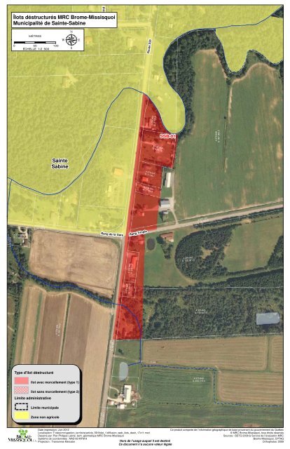
<strong>Îlots</strong> <strong>déstructurés</strong> <strong>MRC</strong> <strong>Brome</strong>-<strong>Missisquoi</strong><br />
Municipalité de <strong>Sainte</strong>-<strong>Sabine</strong><br />
Rue André Sud<br />
! !<br />
! !<br />
0<br />
MÈTRES<br />
50<br />
100<br />
ÉCHELLE 1:2 500<br />
µ<br />
Route 235<br />
! !<br />
! ! ! !<br />
! ! ! ! !<br />
! !<br />
! ! ! !<br />
! ! ! ! ! ! !<br />
! ! ! !<br />
! ! ! ! ! !<br />
! !<br />
! ! ! !<br />
! !<br />
! !<br />
! !<br />
! !<br />
! !<br />
! !<br />
! !<br />
4 376 953<br />
S: 2 734,2<br />
SSB-01<br />
4 375 948<br />
S: 387 860,5<br />
4 376 954<br />
S: 6 241,0<br />
<strong>Sainte</strong><br />
<strong>Sabine</strong><br />
4 376 945<br />
S: 3 136,7<br />
4 376 943<br />
S: 1 384,0<br />
4 376 923<br />
S: 2 737,8<br />
4 376 924<br />
S: 2 257,4<br />
4 377 099<br />
S: 20 182,6<br />
Rang de la Gare<br />
Rang Tringle<br />
4 377 124<br />
S: 22 953,6<br />
4 375 947<br />
S: 125 061,2<br />
4 376 942<br />
S: 2 012,5<br />
4 376 941<br />
S: 1 073,7<br />
4 375 945<br />
S: 116 967,0<br />
4 376 905<br />
S: 432 754,0<br />
Type d'îlot déstructuré<br />
îlot avec morcellement (type 1)<br />
îlot sans morcellement (type 2)<br />
Limite administrative<br />
Limite municipale<br />
Zone non agricole<br />
4 377 348<br />
S: 13 693,7 4 377 349<br />
S: 16 584,4<br />
4 376 913<br />
S: 5 000,0<br />
! !<br />
! ! ! !<br />
! !<br />
! ! ! ! ! !<br />
! !<br />
4 375 940<br />
S: 408 319,4<br />
! !<br />
! !<br />
! ! ! ! ! ! ! ! ! ! ! !<br />
! ! !<br />
! !<br />
! !<br />
Date impression: Juin 2012<br />
Localisation: T:\data\mrc\gestion_territoire\article_59\Volet_1\diffusion_web_ilots_destr_17x11.mxd<br />
Dessiné par: Pier-Philippe Labrie, tech. géomatique <strong>MRC</strong> <strong>Brome</strong>-<strong>Missisquoi</strong><br />
Système de coordonnées : NAD 83 MTM 8<br />
Projection : Transverse Mercator<br />
Hors de l’usage auquel il est destiné<br />
Ce document n’a aucune valeur légale<br />
Ce produit comporte de l’information géographique de base provenant du gouvernement du Québec<br />
© <strong>MRC</strong> <strong>Brome</strong>-<strong>Missisquoi</strong>, tous droits réservés<br />
Sources : BDTQ 2008 & Service de l’évaluation <strong>MRC</strong><br />
<strong>Brome</strong>-<strong>Missisquoi</strong>, CPTAQ<br />
Orthophotos: 2009
! ! ! ! ! !<br />
!<br />
!<br />
! !<br />
!<br />
! ! ! ! ! !<br />
!<br />
! !<br />
! ! ! !<br />
!<br />
!<br />
! !<br />
!<br />
! ! ! ! !<br />
<strong>Îlots</strong> <strong>déstructurés</strong> <strong>MRC</strong> <strong>Brome</strong>-<strong>Missisquoi</strong><br />
Municipalité de <strong>Sainte</strong>-<strong>Sabine</strong><br />
SSB-01<br />
4 375 945<br />
S: 116 967,0<br />
0<br />
MÈTRES<br />
50<br />
100<br />
ÉCHELLE 1:2 500<br />
µ<br />
4 377 349<br />
S: 16 584,4<br />
! !<br />
! ! ! !<br />
! !<br />
! ! ! ! ! !<br />
! !<br />
! !<br />
! !<br />
4 376 913<br />
S: 5 000,0<br />
<strong>Sainte</strong><br />
<strong>Sabine</strong><br />
! ! ! ! ! ! ! ! ! ! ! !<br />
4 376 905<br />
S: 432 754,0<br />
4 375 940<br />
S: 408 319,4<br />
Route 235<br />
4 377 348<br />
S: 13 693,7<br />
4 376 912<br />
S: 5 000,0<br />
SSB-02<br />
4 376 910<br />
S: 3 471,6<br />
4 375 939<br />
S: 393 703,3<br />
4 376 909<br />
S: 2 519,9<br />
4 376 908<br />
S: 1 684,6<br />
4 376 907<br />
S: 1 625,8<br />
Type d'îlot déstructuré<br />
îlot avec morcellement (type 1)<br />
îlot sans morcellement (type 2)<br />
Limite administrative<br />
4 377 108<br />
S: 127 235,9<br />
Limite municipale<br />
4 377 116<br />
S: 14 615,9<br />
4 377 347<br />
S: 21 418,0<br />
4 376 906<br />
S: 10 829,3<br />
4 375 941<br />
S: 448 228,7<br />
Zone non agricole<br />
Date impression: Juin 2012<br />
Localisation: T:\data\mrc\gestion_territoire\article_59\Volet_1\diffusion_web_ilots_destr_17x11.mxd<br />
Dessiné par: Pier-Philippe Labrie, tech. géomatique <strong>MRC</strong> <strong>Brome</strong>-<strong>Missisquoi</strong><br />
Système de coordonnées : NAD 83 MTM 8<br />
Projection : Transverse Mercator<br />
Hors de l’usage auquel il est destiné<br />
Ce document n’a aucune valeur légale<br />
Ce produit comporte de l’information géographique de base provenant du gouvernement du Québec<br />
© <strong>MRC</strong> <strong>Brome</strong>-<strong>Missisquoi</strong>, tous droits réservés<br />
Sources : BDTQ 2008 & Service de l’évaluation <strong>MRC</strong><br />
<strong>Brome</strong>-<strong>Missisquoi</strong>, CPTAQ<br />
Orthophotos: 2009
! ! ! ! ! ! ! ! ! ! ! ! ! ! ! ! ! ! ! ! ! ! ! ! ! ! ! ! ! ! ! ! ! ! ! ! ! ! ! ! ! ! ! ! ! ! ! ! ! ! ! ! ! ! ! ! !<br />
!<br />
!<br />
<strong>Îlots</strong> <strong>déstructurés</strong> <strong>MRC</strong> <strong>Brome</strong>-<strong>Missisquoi</strong><br />
Municipalité de <strong>Sainte</strong>-<strong>Sabine</strong><br />
4 376 905<br />
µ<br />
S: 432 754,0<br />
MÈTRES<br />
0 50<br />
100<br />
ÉCHELLE 1:2 500<br />
4 376 904<br />
S: 77 998,7<br />
4 377 348<br />
S: 13 693,7<br />
4 376 908<br />
S: 1 684,6<br />
SSB-02<br />
4 376 907<br />
S: 1 625,8<br />
4 375 939<br />
S: 393 703,3<br />
4 376 906<br />
S: 10 829,3<br />
4 377 116<br />
S: 14 615,9<br />
4 375 941<br />
S: 448 228,7<br />
4 377 108<br />
S: 127 235,9<br />
Route 235<br />
! ! ! ! ! ! ! ! ! ! ! ! ! ! ! ! ! ! ! ! ! ! ! ! ! ! ! ! ! ! ! ! ! ! ! ! ! ! ! ! ! ! ! ! ! ! ! ! ! ! ! ! ! ! ! ! ! ! ! ! ! ! ! ! ! ! ! ! ! ! ! ! ! ! ! ! ! ! ! ! ! ! ! ! ! ! ! ! ! ! ! ! ! ! !<br />
4 376 901<br />
S: 5 890,2<br />
4 375 937<br />
S: 126 997,5<br />
4 376 894<br />
S: 5 861,7<br />
4 375 934<br />
S: 155 246,5<br />
4 377 110<br />
S: 68 907,0<br />
4 376 899<br />
S: 1 846,7<br />
4 376 903<br />
S: 5 814,5<br />
4 375 933<br />
S: 142 263,0<br />
<strong>Sainte</strong>-<strong>Sabine</strong><br />
4 377 347<br />
S: 21 418,0<br />
SSB-03<br />
4 376 898<br />
S: 2 290,8<br />
! !<br />
! ! !<br />
! !<br />
! ! ! !<br />
! ! ! !<br />
! ! !<br />
! !<br />
! ! !<br />
! !<br />
Type d'îlot déstructuré<br />
4 377 112<br />
S: 97 445,4<br />
4 376 897<br />
S: 5 000,0<br />
4 375 932<br />
S: 368 126,9<br />
! ! !<br />
! ! !<br />
! !<br />
! ! !<br />
! !<br />
îlot avec morcellement (type 1)<br />
! ! ! !<br />
! !<br />
îlot sans morcellement (type 2)<br />
! !<br />
! ! ! !<br />
Limite administrative<br />
! ! ! !<br />
Limite municipale<br />
! ! ! ! ! !<br />
! !<br />
Zone non agricole<br />
4 376 896<br />
S: 4 053,0<br />
Date impression: Juin 2012<br />
Localisation: T:\data\mrc\gestion_territoire\article_59\Volet_1\diffusion_web_ilots_destr_17x11.mxd<br />
Dessiné par: Pier-Philippe Labrie, tech. géomatique <strong>MRC</strong> <strong>Brome</strong>-<strong>Missisquoi</strong><br />
Système de coordonnées : NAD 83 MTM 8<br />
Projection : Transverse Mercator<br />
Hors de l’usage auquel il est destiné<br />
Ce document n’a aucune valeur légale<br />
Ce produit comporte de l’information géographique de base provenant du gouvernement du Québec<br />
© <strong>MRC</strong> <strong>Brome</strong>-<strong>Missisquoi</strong>, tous droits réservés<br />
Sources : BDTQ 2008 & Service de l’évaluation <strong>MRC</strong><br />
<strong>Brome</strong>-<strong>Missisquoi</strong>, CPTAQ<br />
Orthophotos: 2009
! !<br />
! !<br />
! ! ! !<br />
! ! ! ! ! !<br />
! !<br />
! ! ! !<br />
!<br />
! ! ! ! !<br />
! ! ! ! ! ! ! ! ! ! !<br />
Route 235<br />
!<br />
! !<br />
!<br />
! ! !<br />
! ! ! ! ! !<br />
! ! !<br />
! ! ! !<br />
<strong>Îlots</strong> <strong>déstructurés</strong> <strong>MRC</strong> 4 377 114 <strong>Brome</strong>-<strong>Missisquoi</strong><br />
S: 152 008,9<br />
Municipalité de <strong>Sainte</strong>-<strong>Sabine</strong><br />
4 375 931<br />
S: 220 185,0<br />
0<br />
MÈTRES<br />
50<br />
100<br />
ÉCHELLE 1:2 500<br />
µ<br />
4 377 477<br />
S: 13 134,0<br />
4 376 888<br />
S: 4 875,0<br />
4 375 930<br />
S: 203 783,0<br />
60 m<br />
4 376 887<br />
S: 4 874,4<br />
SSB-04<br />
4 377 081<br />
S: 154 042,1<br />
4 377 230<br />
S: 3 779,1<br />
4 376 883<br />
S: 1 393,0<br />
4 376 886<br />
S: 2 934,6<br />
4 375 929<br />
S: 389 947,9<br />
4 376 882<br />
S: 1 393,0<br />
60 m<br />
4 376 885<br />
S: 2 879,2<br />
4 377 459<br />
S: 3 766,5<br />
Rang Coulombe<br />
60 m<br />
4 376 879<br />
S: 2 669,8<br />
4 376 881<br />
S: 2 786,0<br />
4 376 880<br />
S: 3 227,6<br />
4 376 884<br />
S: 5 757,0<br />
4 377 103<br />
S: 14 775,0<br />
<strong>Sainte</strong><br />
<strong>Sabine</strong><br />
4 377 229<br />
S: 17 985,8<br />
4 377 612<br />
S: 17 985,8<br />
4 376 877<br />
S: 1 388,7<br />
4 375 928<br />
S: 218 200,3<br />
60 m<br />
4 377 123<br />
S: 123 683,3<br />
4 376 876<br />
S: 3 405,8<br />
4 377 613<br />
S: 203 349,8<br />
! !<br />
! ! ! !<br />
! ! ! !<br />
! ! ! ! !<br />
! !<br />
! ! ! ! ! ! ! ! ! ! !<br />
! !<br />
! !<br />
! ! ! !<br />
4 376 995<br />
S: 16 454,3<br />
4 375 927<br />
S: 8 844,7<br />
! ! ! !<br />
! ! ! !<br />
! !<br />
! !<br />
! !<br />
! ! ! ! ! !<br />
! !<br />
! ! !<br />
! !<br />
! !<br />
! !<br />
! !<br />
! !<br />
! !<br />
! !<br />
! ! ! !<br />
! !<br />
! ! ! ! ! !<br />
! !<br />
Type d'îlot déstructuré<br />
! !<br />
! !<br />
! ! ! !<br />
! !<br />
! ! ! ! ! ! ! ! ! !<br />
îlot avec morcellement (type 1)<br />
4 375 923<br />
S: 428 843,7<br />
4 377 161<br />
S: 85 769,4<br />
îlot sans morcellement (type 2)<br />
Limite administrative<br />
Limite municipale<br />
Zone non agricole<br />
Date impression: Juin 2012<br />
Localisation: T:\data\mrc\gestion_territoire\article_59\Volet_1\diffusion_web_ilots_destr_17x11.mxd<br />
Dessiné par: Pier-Philippe Labrie, tech. géomatique <strong>MRC</strong> <strong>Brome</strong>-<strong>Missisquoi</strong><br />
Système de coordonnées : NAD 83 MTM 8<br />
Projection : Transverse Mercator<br />
Hors de l’usage auquel il est destiné<br />
Ce document n’a aucune valeur légale<br />
Ce produit comporte de l’information géographique de base provenant du gouvernement du Québec<br />
© <strong>MRC</strong> <strong>Brome</strong>-<strong>Missisquoi</strong>, tous droits réservés<br />
Sources : BDTQ 2008 & Service de l’évaluation <strong>MRC</strong><br />
<strong>Brome</strong>-<strong>Missisquoi</strong>, CPTAQ<br />
Orthophotos: 2009
<strong>Îlots</strong> <strong>déstructurés</strong> <strong>MRC</strong> <strong>Brome</strong>-<strong>Missisquoi</strong><br />
Municipalité de <strong>Sainte</strong>-<strong>Sabine</strong><br />
0<br />
MÈTRES<br />
50<br />
100<br />
ÉCHELLE 1:2 500<br />
µ<br />
4 377 060<br />
S: 28 268,8<br />
4 376 841<br />
S: 221 442,3<br />
<strong>Sainte</strong><br />
<strong>Sabine</strong><br />
4 376 914<br />
S: 8 619,4<br />
Rang Beaulieu<br />
4 376 837<br />
S: 6 087,7<br />
4 376 832<br />
S: 10 995,1<br />
! ! ! ! ! !<br />
Rang de la Gare<br />
! ! ! !<br />
! ! ! ! ! ! ! ! ! ! ! ! ! ! ! ! ! ! ! ! ! ! ! ! ! ! ! ! ! ! ! ! ! ! ! ! ! ! ! ! ! ! ! ! ! ! ! ! ! ! ! ! ! ! ! ! ! ! ! ! ! ! ! ! ! ! ! ! ! ! ! ! ! ! ! ! ! ! ! ! ! ! ! ! ! ! ! ! ! ! ! ! ! !<br />
4 376 831<br />
S: 5 000,0<br />
4 376 834<br />
S: 2 642,1<br />
4 376 838<br />
S: 512 323,0<br />
4 377 047<br />
S: 188 954,3<br />
4 376 842<br />
S: 8 623,2<br />
4 377 099<br />
S: 20 182,6<br />
SSB-06<br />
4 377 324<br />
S: 21 595,1<br />
4 376 835<br />
S: 51 748,3<br />
4 377 046<br />
S: 41 341,9<br />
4 376 836<br />
S: 238 165,0<br />
4 377 100<br />
S: 12 940,6<br />
4 376 829<br />
S: 22 213,7<br />
Rang Campbell<br />
Type d'îlot déstructuré<br />
îlot avec morcellement (type 1)<br />
îlot sans morcellement (type 2)<br />
Limite administrative<br />
Limite municipale<br />
Zone non agricole<br />
4 376 830<br />
S: 379 553,8<br />
Date impression: Juin 2012<br />
Localisation: T:\data\mrc\gestion_territoire\article_59\Volet_1\diffusion_web_ilots_destr_17x11.mxd<br />
Dessiné par: Pier-Philippe Labrie, tech. géomatique <strong>MRC</strong> <strong>Brome</strong>-<strong>Missisquoi</strong><br />
Système de coordonnées : NAD 83 MTM 8<br />
Projection : Transverse Mercator<br />
Hors de l’usage auquel il est destiné<br />
Ce document n’a aucune valeur légale<br />
Ce produit comporte de l’information géographique de base provenant du gouvernement du Québec<br />
© <strong>MRC</strong> <strong>Brome</strong>-<strong>Missisquoi</strong>, tous droits réservés<br />
Sources : BDTQ 2008 & Service de l’évaluation <strong>MRC</strong><br />
<strong>Brome</strong>-<strong>Missisquoi</strong>, CPTAQ<br />
Orthophotos: 2009
<strong>Îlots</strong> <strong>déstructurés</strong> <strong>MRC</strong> <strong>Brome</strong>-<strong>Missisquoi</strong><br />
Municipalité de <strong>Sainte</strong>-<strong>Sabine</strong><br />
MÈTRES<br />
0 50<br />
100<br />
ÉCHELLE 1:2 500<br />
µ<br />
4 377 073<br />
S: 70 428,4<br />
4 377 537<br />
S: 108 647,5<br />
4 377 059<br />
S: 135 571,6<br />
4 375 948<br />
S: 387 860,5<br />
4 375 952<br />
S: 44 093,4<br />
4 375 985<br />
S: 5 828,3<br />
4 375 955<br />
S: 2 647,9<br />
4 375 954<br />
S: 5 000,0<br />
4 375 951<br />
S: 11 423,4<br />
4 375 950<br />
S: 11 514,5<br />
4 375 984<br />
S: 135 295,6<br />
4 375 986<br />
S: 1 312,6<br />
4 375 987<br />
S: 2 611,1<br />
4 377 463<br />
S: 9 667,9<br />
SSB-07-B<br />
4 377 124<br />
S: 22 953,6<br />
Rang Tringle<br />
SSB-07-A<br />
4 375 988<br />
S: 4 874,6<br />
4 375 989<br />
S: 432 243,3<br />
4 375 994<br />
S: 701 013,8<br />
4 375 949<br />
S: 8 821,6<br />
4 375 947<br />
S: 125 061,2<br />
Type d'îlot déstructuré<br />
4 375 953<br />
S: 344 892,5<br />
îlot avec morcellement (type 1)<br />
îlot sans morcellement (type 2)<br />
Limite administrative<br />
Limite municipale<br />
Zone non agricole<br />
4 375 945<br />
S: 116 967,0<br />
<strong>Sainte</strong>-<strong>Sabine</strong><br />
Date impression: Juin 2012<br />
Localisation: T:\data\mrc\gestion_territoire\article_59\Volet_1\diffusion_web_ilots_destr.mxd<br />
Dessiné par: Pier-Philippe Labrie, tech. géomatique <strong>MRC</strong> <strong>Brome</strong>-<strong>Missisquoi</strong><br />
Système de coordonnées : NAD 83 MTM 8<br />
Projection : Transverse Mercator<br />
Hors de l’usage auquel il est destiné<br />
Ce document n’a aucune valeur légale<br />
Ce produit comporte de l’information géographique de base provenant du gouvernement du Québec<br />
© <strong>MRC</strong> <strong>Brome</strong>-<strong>Missisquoi</strong>, tous droits réservés<br />
Sources : BDTQ 2008 & Service de l’évaluation <strong>MRC</strong><br />
<strong>Brome</strong>-<strong>Missisquoi</strong>, CPTAQ<br />
Orthophotos: 2009
<strong>Îlots</strong> <strong>déstructurés</strong> <strong>MRC</strong> <strong>Brome</strong>-<strong>Missisquoi</strong><br />
Municipalité de <strong>Sainte</strong>-<strong>Sabine</strong><br />
µ<br />
MÈTRES<br />
0 50<br />
100<br />
ÉCHELLE 1:2 500<br />
4 355 783<br />
S: 236 946,4<br />
! ! ! ! ! ! ! ! ! ! ! ! ! ! ! ! ! ! ! ! ! ! ! ! ! ! ! ! ! ! ! ! ! ! ! ! ! ! ! ! ! ! ! ! ! ! ! ! ! ! ! ! ! ! ! ! ! ! ! ! ! ! ! ! ! ! ! ! ! ! ! ! ! !<br />
4 355 781<br />
S: 153 787,8<br />
4 355 804<br />
S: 27 903,9<br />
FAR-16<br />
4 353 798<br />
S: 27 925,0<br />
4 353 797<br />
S: 12 539,6<br />
4 353 794<br />
S: 8 174,3<br />
4 354 027<br />
S: 1 849,8<br />
4 354 234<br />
S: 25 969,3<br />
Farnham<br />
4 354 011<br />
S: 11 920,8<br />
SSB-08<br />
4 377 371<br />
S: 2 859,1<br />
Ch. Jetté<br />
4 354 235<br />
S: 14 527,8<br />
4 375 866<br />
S: 998,4<br />
4 375 867<br />
S: 1 396,5<br />
4 375 873<br />
S: 1 374,3<br />
Rue Couture<br />
Route 235<br />
Rue Fortier<br />
4 375 864<br />
S: 45 768,7<br />
4 375 863<br />
S: 314 667,2<br />
Rue Guérin<br />
Rue Laflamme<br />
4 375 865<br />
S: 64 525,7<br />
Type d'îlot déstructuré<br />
îlot avec morcellement (type 1)<br />
îlot sans morcellement (type 2)<br />
Limite administrative<br />
<strong>Sainte</strong><br />
<strong>Sabine</strong><br />
Rue André Nord<br />
Limite municipale<br />
Zone non agricole<br />
Date impression: Juin 2012<br />
Localisation: T:\data\mrc\gestion_territoire\article_59\Volet_1\diffusion_web_ilots_destr_17x11.mxd<br />
Dessiné par: Pier-Philippe Labrie, tech. géomatique <strong>MRC</strong> <strong>Brome</strong>-<strong>Missisquoi</strong><br />
Système de coordonnées : NAD 83 MTM 8<br />
Projection : Transverse Mercator<br />
Hors de l’usage auquel il est destiné<br />
Ce document n’a aucune valeur légale<br />
Ce produit comporte de l’information géographique de base provenant du gouvernement du Québec<br />
© <strong>MRC</strong> <strong>Brome</strong>-<strong>Missisquoi</strong>, tous droits réservés<br />
Sources : BDTQ 2008 & Service de l’évaluation <strong>MRC</strong><br />
<strong>Brome</strong>-<strong>Missisquoi</strong>, CPTAQ<br />
Orthophotos: 2009