

FKKD - DOUALA - CARACTÃRISTIQUES DE L'AÃRODROME
FKKD - DOUALA - CARACTÃRISTIQUES DE L'AÃRODROME
FKKD - DOUALA - CARACTÃRISTIQUES DE L'AÃRODROME

Create successful ePaper yourself
Turn your PDF publications into a flip-book with our unique Google optimized e-Paper software.
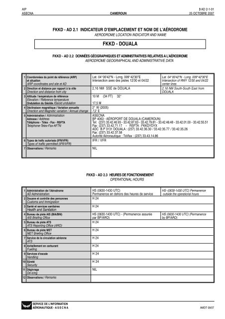
3 AD 2-1-02 AIP27 SEPTEMBRE 2007 CAMEROUN ASECNA<strong>FKKD</strong> - AD 2.4 SERVICES D’ESCALE ET D’ASSISTANCEHANDLING SERVICES AND FACILITIES1 Services de manutention du frêt Matériel de la Société des aéroports du Cameroun Handling equipments Cameroun AirportCargo handling facilities (ADC)) (ADC)2 Types de carburants et de lubrifiant AVGAS 100 LL - JET A1Fuel/Oil types3 Services et capacité d’avitaillement Static refuelling : Static refuelling JET A1 : 2 tanksen carburant / Fuelling facilities / capacity JET A1 : 2 cuves 720 M 3 chacune- débit 120 M 3 /H 720 M 3 each one - Flow 120 M 3 /HJET A 2 : Citerne ravitailleur 5 M 3 JET A2 : tank truck 5 M 3débit 15 M 3 /H de la station MOBIL Flow 15 M 3 /H Mobil station3 oléoserveurs 3 oléoserveursAVGAS 100LL disponible au dépôt pétrolier et en fûts4 Services de dégivrage NILDe-icing facilities5 Hangars utilisables pour les aéronefs de NILpassage / Hangar space for visiting aircrafts6 Services de réparations utilisable pour les Possibilité de petites et moyennes réparations par Small and minor repairs possibility byaéronefs de passage / Repair facilities for Cameroun Airlines, Cameroun Hélicoptères et Cameroon Airlines, Cameroon Helicoptersvisiting aircrafts Armée de l'Air and Air Force7 Observations / Remarks NIL<strong>FKKD</strong> - AD 2.5 SERVICES AUX PASSAGERSPASSENGER FACILITIES1 Hôtels / Hotels En ville In the city2 Restaurants / Restaurants A l'aéroport (<strong>DOUALA</strong>IR) et en ville At the AD (<strong>DOUALA</strong>IR) and in the city3 Moyens de transport / Transportation facilities Taxis - Voitures de location avec ou Taxis - rental cars with or withoutsans chauffeurdriver4 Services médicaux / Medical facilities Infirmerie de l’aéroport - Hôpitaux, dispensaires, AD infirmary, Hospital, free clinics,laboratoires et cliniques en villelaboratories and private clinics in the city5 Service bancaires et postaux A l’aéroport et en ville. Ouverture pendant les At the AD and in the city. Open duringBank and Post Office heures de service the operational hours6 Services d’information touristique Bureau en ville Office in the cityTourist Office7 Observations / Remarks NIL<strong>FKKD</strong> - AD 2.6 SERVICES <strong>DE</strong> SAUVETAGE ET <strong>DE</strong> LUTTE CONTRE L’INCENDIERESCUE AND FIRE FIGHTING SERVICES1 Catégorie de l’aérodrome pour la lutte Niveau de protection assuré : 8 Ensured protection level : 8contre l’incendie / AD category for fire fighting H 24 H 242 Véhicules incendie 1 VIPP 4425C 4000 L eau + 400 L émulseur + 250 KG poudreFire Fighting Vehicles1 VIMP 91125S 9000 L eau + 1000 L émulseur + 250 KG poudre1 VIMP 81025C 8000 L eau + 1000 L émulseur+ 250 KG poudre1 FLYCO équipée de dispositifs d’effarouchement et lutte contre le péril aviaireADD : 1 VIMP 71025S 7500 L eau + 1150 L émulseur + 250 KG poudreErsi : (renfort) 1 VIMP 71025S 7500 L eau + 1150 L émulseur + 250 KG poudreADD 1 VIPP 3325S 3000 L eau + 300 L émulseur + 150 KG poudreForces Aériennes Camerounaises : NILMoyens en ville : 2 véhicules citernes - 1 motopompeCapacité des véhicules : 3500L eau + (émulseur variable en bidons)3 Equipement de sauvetage Conformément aux recommandations OACI In accordance with ICAO standardsRescue Equipment4 Moyens d’enlèvement des aéronefs NILaccidentellement immobilisésCapability for removal of disabled aircrafts5 Observations / Remarks NIL1 Types d’équipement NILTypes of clearing equipment2 Priorité de déneigement NILClearance priority3 Observations / Remarks NIL<strong>FKKD</strong> - AD 2.7 DISPONIBILITÉS SAISONNIÉRES - DÉNEIGEMENTSEASONAL AVAILABILITY - CLEARINGAMDT 07/07SERVICE <strong>DE</strong> L’INFORMATIONAÉRONAUTIQUE - A S E C N A
AIP 3 AD 2-1-05ASECNA CAMEROUN 15 FÉVRIER 2007<strong>FKKD</strong> - AD 2.12 CARACTÉRISTIQUES PHYSIQUES <strong>DE</strong>S PISTESRUNWAY PHYSICAL CHARACTERISTICSRelèvements Dimensions Résistance (PCN) et Altitude du seuil et duNuméro VRAI et MAG des RWY (M) revêtement des RWY et SWY Coordonnées du seuil point le plus élevé de la TDZde piste True and Mag Dimensions of Strength (PCN) and Threshold THR THR elevation and highestRWY NR Bearing RWY (M) surface of RWY and SWY Coordinates elevation of TDZ of precision RWY1 2 3 4 5 612 116,8° VRAI 2850 x 45 PCN 59/F/C/X/U 04°00’42,72”N Seuil 12 : 10 M (34 FT)119° MAG Composite 009°42’28,96”E30 293,8° VRAI 2850 x 45 PCN 59/F/C/X/U 04°00’00,87”N Seuil 30 : 4 M (14 FT)299° MAG Composite 009°43’51,51”E TDZ : 10 M (34 FT)Pente de Dimensions Dimensions Zone dégagéeRWY/SWY PA (M) PD (M) Dimensions de la bande (M) d’obstacle ObservationsRWY/SWY SWY CWY Strip Dimensions Obstacle free zone RemarksSlope Dimensions Dimensions (OFZ)7 8 9 10 11 1212 50 100 2950 x 45 Voir carte d’obstacle Seuil 12 : 10 M (34 FT)30 50 2900 x 45 Seuil 30 : 4 M (14 FT)TDZ : 10 M (34 FT)<strong>FKKD</strong> - AD 2.13 DISTANCES DÉCLARÉES<strong>DE</strong>CLARED DISTANCESDésignation de la piste TORA TODA ASDA LDA ObservationsRWY NR (M) (M) (M) (M) Remarks1 2 3 4 5 612 2850 2950 2900 2850 PA/SWY = 50 M - PD/CWY = 100 M30 2850 2850 2900 2850 PA/SWY = 50 MSERVICE <strong>DE</strong> L’INFORMATIONAÉRONAUTIQUE - ASECNA AMDT 02/07
3 AD 2-1-06 AIP03 JUILLET 2008 CAMEROUN ASECNA<strong>FKKD</strong> - AD 2.14 DISPOSITIF LUMINEUX D’APPROCHE ET BALISAGE LUMINEUX <strong>DE</strong> PISTEAPPROACH AND RUNWAY LIGHTINGDésignation de la Type et intensité du balisage Couleur des feux PAPI Zone depiste lumineux d’approche de seuil et barres Position/Pente toucher des rouesRWY designator Approach lighting type, length intensity THR Lights colour wing Location/Slope TDZ, LGT,bar lights WBAR MEHT (FT) length1 2 3 4 512 Vert Gauche 3° NILBalisage diurne30 HI Cat. 1 - 900 M directionnelle à Vert NILbarrettes avec balle traçanteDay paint markingBI omnidirectionnelle simplifiéeLongueur, espacement, Longueur, espacement, Couleur des feux Longueur, couleurcouleur des feux d’axe couleur des feux de bord de piste d’extrémité de piste des feux de Observationsde piste RWY edge lights, length, RWY end lights, LEN, prolongement d’arrêt RemarksRWY centre line, length, spacing, colour, intensity spacing, colour, intensity SWY lights lengthspacing, colour, intensitycolour6 7 8 9 10NIL 2850 M - 60 M - Blanc HI Rouge RougeNIL 2850 M - 60 M - White HI Red Red<strong>FKKD</strong> - AD 2.15 AUTRES DISPOSITIFS LUMINEUX, ALIMENTATION AUXILIAIREOTHER LIGHTING, SECONDARY POWER SUPPLY1 Emplacement, caractéristique et heures de NILfonctionnement des phares d’aérodrome/d’identification / ABN/IBN location, characteristicsand hours of operation2 Emplacement et éclairage de l’anémomètre/ Anémomètres installés près du Glide/ILS Anemometers installed near Glide/ILSIndicateur de sens d’atterrissage et au parc MTO station and in the MTO parkAnemometer location and lighting Manche à air lumineuse Lighted windsockLDI location and lighting3 Feux de bord de voies de circulation et Feux de voies de circulation : Bleus TWY edge lights : Bluefeux axiaux de voies de circulation Feux axiaux de voies de circulation : NIL TWY centerline lights : NILTWY edge and centre line lighting4 Alimentation électrique auxiliaire/ Alimentation secourue par 2 groupes de 250 KVA Stand-by power provided by 2 dieseldélai de commutation et par des onduleurs. emergency power units 250 KVA and UPSSecondary power supply / switch-over time Temps de commutation : inférieur à 10s et à 1s Switch-over time : less than 10s and 1sen fonctionnement ”secours inversé”if ”emergency inverse” in service5 Observations / Remarks Obstacles importants balisés de jour et de nuit High obstacles with day marking and night1 feu aéronautique au sol <strong>DOUALA</strong> - 5.é (12 sec) obstruction light - 1 ground aeronauticalLat. 04°01'N - Long. 09°43'Elight <strong>DOUALA</strong> 5.é (12 sec)Lat. 04°01'N - Long. 09°43'E<strong>FKKD</strong> - AD 2.16 AIRE D’ATTERRISSAGE D’HÉLICOPTÈRESHELICOPTER LANDING AREA1 Coordonnées TLOF ou THR de la FATO H1, H2 :Lat. 04°01’06,70”N - lONG; 009°42’33,77”ECoordinates TLOF or THR of FATOParking CHC Lat. : 04°01'10,2"N - Long. : 009°42'52,74"E2 Altitude TLOF/FATO (M/Ft) H1 et H2 : 9 M (30 FT)TLOF and FATO elevation (M/Ft)3 TLOF + FATO : Aire, dimensions, revêtement, H1, H2 : Deux aires de 18,5 x 7 m2 chacune, Béton, Résistance : 9T, Balisage diurnerésistance, balisage / TLOF and FATO area Parking CHC : 61,84 x 39,20 m2 , Béton, Résistance : 27 T , Balisage diurnedimensions, surface, strength, marking4 Relèvements vrai et magnétique de la FATO 1070 m QDR 047° ARPTrue and mc agnetibearing of FATO5 Distances déclarées disponiblesDeclared distances available6 Dispositif lumineux d’approche et de FATO H2 : Balisage fixe : feux jaunes omnidirectionnels disposés en cercle au solApproach and FATO lightingParking CHC : Balisage mobile : douze feux blancs omnidirectionnels disposés en cercpour chaque atterrissage7 Observations / Remarks Obstacle situé au 300° de H2 à 0,6 NM : Hauteur 200 FTH1 et H2 : propriétés de Cameroon HelicoptersParking CHC : propriété de CHC Helicopter corporationAMDT 05/08SERVICE <strong>DE</strong> L’INFORMATIONAÉRONAUTIQUE - A S E C N A
AIP 3 AD 2-1-07ASECNA CAMEROUN 16 JANVIER 2008<strong>FKKD</strong> - AD 2.17 ESPACE AÉRIEN ATSATS AIRSPACE1 Désignation et limites latérales CTR <strong>DOUALA</strong> : Cercle de 30 NM de rayon centré <strong>DOUALA</strong> CTR : Circle of 30 NMDesignation and laterals limits sur le VOR/DME ”DLA” radius centred on the VOR/DME ”DLA”03°59'38,1"N - 009°44'36,5"E03°59'38,1"N- 009°44'36,5"E2 Limites verticales / Vertical limits FL 60/SOL-MER FL 60/GND-MSL3 Classification de l’espace aérien DAirspace classification4 Indicatif d’appel et langues de l’organe <strong>DOUALA</strong> TOUR - Français (Fr) - Anglais (En)ATS unit call sign/Languages5 Altitude de transition / Transition altitude 2200 FT6 Observations / Remarks Aérodrome interdit aux aéronefs non munis de AD prohibited for ACFT not equippedradiocommunications bilatérales. Demi-tour complet with bilateral radio communicationsinterdit sur la piste 12/30 pour tout aéronef d'un poids Complete U-turn on RWY 12/30supérieur à 40 TN. A l'atterrissage, le demi-tour prohibited for ACFT superior to 40 Tdoit être effectué aux extrémités de piste sur les weight. After take-off, u-turn must beraquettes de retournement. De nuit, tout décollage effected in the end of runway on thed'avions à réaction entre 2000 et 0600 UTC devra turn-arounds areas. Night take-off ofse faire au QFU 12. Le décollage au QFU 30 ne jet aircrafts between 2000 and 0600 UTCsera autorisé que sur demande expresse du must be effected in RWY 12. Take-off inCommandant de Bord si les conditions météorolo- RWY 30 will be authorized only on urgentgiques rendent le décollage dans ce sens request of the pilot in command if theobligatoiremeteorological conditions obliged thetake-off to use obligatory that way.<strong>FKKD</strong> - AD 2.18 INSTALLATIONS <strong>DE</strong> TÉLÉCOMMUNICATION <strong>DE</strong>S SERVICES<strong>DE</strong> LA CIRCULATION AÉRIENNE / ATS COMMUNICATION FACILITIESDésignation Indicatif d’appel Fréquences Heures de Observationsdu service Call sign (MHZ - KHZ) fonctionnement RemarksService designation Frequency Hours of operation1 2 3 4 5TWR <strong>DOUALA</strong> TOUR 119,7 MHZ H 24 Assure APPACC <strong>DOUALA</strong> CONTROLE 129,5 MHZ H 24 P : 50 W5493 - 5873 - 6559 - 8873 -8903 - P : 1 KW5519 - 6666 - 13294KHZ<strong>FKKD</strong> - AD 2.19 AI<strong>DE</strong>S <strong>DE</strong> RADIONAVIGATION ET D’ATTERRISSAGERADIO NAVIGATION AND LANDING AIDSType d’Aide/ Fréquences Heures de Coordonnées Altitude deDéclinaison Identification (MHZ-KHZ) fonctionnement antenne émission l’antenne ObservationsType of AID Identification Freguency Hours of Site of antenna Elevation of RemarksMagnetic variation operation coordinates DME antenna1 2 3 4 5 6 7VOR/DME DLA 112,9 MHZ H 24 03°59’38,1”N 12 M P. VOR : 50 W2° W (2005) CH 76 X 009°44'36,5"E (39 FT) P. DME : 1 KWILS/LLZ DL 110,3 MHZ H 24 04°00'48,94"N 9 M 424 M seuil 12CAT. II 009°42'16,69"E (31 FT) QDR 299°2° W (2005)ALD/DME.P 335 MHZ H 24 04°00'02,07"N 10 M Angle descente : 3°2° W (2005) CH 40X 009°43'40,14"E (33 FT) Glide path slope : 3°CAT. II jusqu’au seuilCat. II until the THR of RWYNDB YK 398,5 KHZ H 24 03°58'29,1"N 38 M 6488 M seuil 30009°47'01,0"E (126 FT) QDR 118° - P. : 100 WL <strong>DE</strong> 362 KHZ H 24 03°47'26,8"N P. : 100 W010°08'17,0"ESERVICE <strong>DE</strong> L’INFORMATIONAÉRONAUTIQUE - ASECNA AMDT 01/08
![KYIV/Boryspil' / ÐÐÐÐ/ÐоÑиÑÐ¿Ð¾Ð»Ñ UKBB AD 2 [] State Aviation ...](https://img.yumpu.com/40921659/1/184x260/kyiv-boryspil-3-4-nn-3-4-n-ukbb-ad-2-state-aviation-.jpg?quality=85)