A survey of Lepidoptera in three priority areas of the Minnesota state ...
A survey of Lepidoptera in three priority areas of the Minnesota state ...
A survey of Lepidoptera in three priority areas of the Minnesota state ...

Create successful ePaper yourself
Turn your PDF publications into a flip-book with our unique Google optimized e-Paper software.
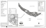
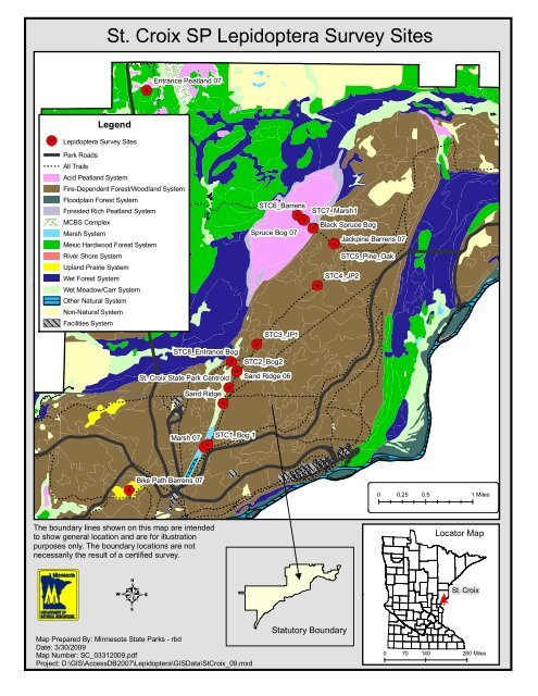
Legend<br />
<strong>Lepidoptera</strong> Survey Sites<br />
Park Roads<br />
All Trails<br />
Acid Peatland System<br />
Fire-Dependent Forest/Woodland System<br />
Floodpla<strong>in</strong> Forest System<br />
Forested Rich Peatland System<br />
MCBS Complex<br />
Marsh System<br />
Mesic Hardwood Forest System<br />
River Shore System<br />
Upland Prairie System<br />
Wet Forest System<br />
Wet Meadow/Carr System<br />
O<strong>the</strong>r Natural System<br />
Non-Natural System<br />
Facilities System<br />
St. Croix SP <strong>Lepidoptera</strong> Survey Sites<br />
Entrance Peatland 07<br />
STC8_Entrance Bog<br />
St. Croix State Park Centroid<br />
Sand Ridge<br />
Marsh 07<br />
Bike Path Barrens 07<br />
The boundary l<strong>in</strong>es shown on this map are <strong>in</strong>tended<br />
to show general location and are for illustration<br />
purposes only. The boundary locations are not<br />
necessarily <strong>the</strong> result <strong>of</strong> a certified <strong>survey</strong>.<br />
STC1_Bog 1<br />
Map Prepared By: M<strong>in</strong>nesota State Parks - rbd<br />
Date: 3/30/2009<br />
Map Number: SC_03312009.pdf<br />
Project: D:\GIS\AccessDB2007\<strong>Lepidoptera</strong>\GISData\StCroix_09.mxd<br />
STC6_Barrens<br />
Spruce Bog 07<br />
STC3_JP1<br />
STC2_Bog2<br />
Sand Ridge 06<br />
STC7_Marsh1<br />
Black Spruce Bog<br />
Jackp<strong>in</strong>e Barrens 07<br />
STC5_P<strong>in</strong>e_Oak<br />
STC4_JP2<br />
Statutory Boundary<br />
0 0.25 0.5 1 Miles<br />
Locator Map<br />
St. Croix<br />
0 70 140 280 Miles