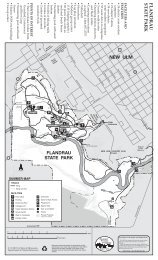
Garden Island SRA map - Minnesota Department of Natural ...
Garden Island SRA map - Minnesota Department of Natural ...
Garden Island SRA map - Minnesota Department of Natural ...

Create successful ePaper yourself
Turn your PDF publications into a flip-book with our unique Google optimized e-Paper software.
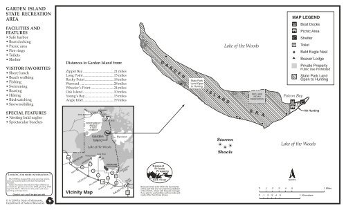
GARDEN ISLAND<br />
STATE RECREATION<br />
AREA<br />
FACILITIES AND<br />
FEATURES<br />
• Safe harbor<br />
• Boat docking<br />
• Picnic area<br />
• Fire rings<br />
•Toilets<br />
• Shelter<br />
VISITOR FAVORITIES<br />
• Shore lunch<br />
• Beach walking<br />
• Fishing<br />
•Swimming<br />
• Boating<br />
•Hiking<br />
• Birdwatching<br />
• Snowmobiling<br />
Distances to <strong>Garden</strong> <strong>Island</strong> from:<br />
Zippel Bay ....................................21 miles<br />
Long Point....................................15 miles<br />
Rocky Point ..................................18 miles<br />
Warroad ........................................28 miles<br />
Wheeler’s Point ...........................24 miles<br />
Oak <strong>Island</strong> ....................................10 miles<br />
Young’s Bay..................................15 miles<br />
Angle Inlet....................................19 miles<br />
GARDEN<br />
State Park<br />
Land Open<br />
to Hunting<br />
ISLAND<br />
Lake <strong>of</strong> the Woods<br />
RED LAKE<br />
INDIAN<br />
RESERVATION<br />
MAP LEGEND<br />
Falcon Bay<br />
Boat Docks<br />
Picnic Area<br />
Shelter<br />
Toilet<br />
Bald Eagle Nest<br />
Beaver Lodge<br />
Private Property<br />
Public Use Prohibited<br />
State Park Land<br />
Open to Hunting<br />
SPECIAL FEATURES<br />
• Nesting bald eagles<br />
• Spectacular beaches<br />
ANGLE INLET<br />
NORTHWEST<br />
ANGLE<br />
STATE<br />
FOREST<br />
PENASSE<br />
Young’s<br />
Bay<br />
OAK ISLAND<br />
S. R. A.<br />
No Hunting<br />
LOOKING FOR MORE INFORMATION ?<br />
The DNR has <strong>map</strong>ped the state showing federal,<br />
state and county lands with their recreational<br />
facilities.<br />
Public Recreation Information Maps (PRIM) are<br />
available for purchase from the DNR gift shop, DNR<br />
regional <strong>of</strong>fices, <strong>Minnesota</strong> state parks and major<br />
sporting and <strong>map</strong> stores.<br />
Check it out - you'll be glad you did.<br />
313<br />
WARROAD<br />
SWIFT<br />
12<br />
ARNESON<br />
ROOSEVELT<br />
17<br />
Vicinity Map<br />
<strong>Garden</strong><br />
<strong>Island</strong><br />
Lake <strong>of</strong> the Woods<br />
Rocky Point<br />
8<br />
WILLIAMS<br />
Long Point<br />
2<br />
LUDE<br />
11<br />
GRACETON<br />
ZIPPEL BAY<br />
STATE PARK<br />
4<br />
8<br />
PITT<br />
172<br />
6<br />
Big <strong>Island</strong><br />
BAUDETTE<br />
WHEELER'S<br />
POINT<br />
RAINY<br />
RIVER<br />
72<br />
Because lands exist within the boundaries<br />
<strong>of</strong> this park that are not under the jurisdiction<br />
<strong>of</strong> the D.N.R., check with the park manager<br />
if you plan to use facilities such as trails and<br />
roads other than those shown.<br />
Starren<br />
Shoals<br />
Lake <strong>of</strong> the Woods<br />
0 .1 .2 .3 .4<br />
NORTH<br />
.5 1 Miles<br />
0 .1 .2 .3 .4 .5 1 Kilometers<br />
© 9/2009 by State <strong>of</strong> <strong>Minnesota</strong>,<br />
<strong>Department</strong> <strong>of</strong> <strong>Natural</strong> Resources
GARDEN ISLAND<br />
STATE RECREATION AREA<br />
Minneapolis/<br />
St. Paul •<br />
Duluth<br />
•<br />
GARDEN ISLAND<br />
STATE RECREATION AREA<br />
FOR MORE INFORMATION<br />
Zippel Bay State Park<br />
3684 54th Avenue NW<br />
Williams, MN 56686<br />
(218) 783-6252<br />
♦<br />
<strong>Department</strong> <strong>of</strong> <strong>Natural</strong> Resources<br />
Information Center<br />
500 Lafayette Road<br />
St. Paul, MN 55155-4040<br />
(651) 296-6157 (Metro Area)<br />
1-888-646-6367 (MN Toll Free)<br />
TDD (Telecommunications<br />
Device for Deaf)<br />
(651) 296-5484 (Metro Area)<br />
1-800-657-3929 (MN Toll Free)<br />
DNR Web Site: www.dnr.state.mn.us<br />
<strong>Garden</strong> <strong>Island</strong> State Recreation Area is located 18<br />
miles due north <strong>of</strong> Zippel Bay State Park. It is situated<br />
in the SE corner <strong>of</strong> the Northwest Angle, some 15<br />
miles from the Angle Inlet and 10 miles from Oak<br />
<strong>Island</strong>.<br />
Getting out to this 762-acre island is part <strong>of</strong> its<br />
attraction. Setting course across the Big Traverse Bay<br />
<strong>of</strong> Lake <strong>of</strong> the Woods to <strong>Garden</strong> <strong>Island</strong> is a great<br />
experience in itself. As visitors set their bearings from<br />
the lake’s south shore for this island that can not yet<br />
be seen across the distant horizon, they will truly<br />
appreciate the size <strong>of</strong> this big lake. Once visitors have<br />
reached <strong>Garden</strong> <strong>Island</strong>, they are still not even close<br />
to the northern side <strong>of</strong> this massive lake. At its farthest<br />
reaches, Lake <strong>of</strong> the Woods is 90 miles long by 55<br />
miles wide. This lake is truly ocean-like in its size<br />
and moods. Imagine a lake with 1,485 square miles<br />
<strong>of</strong> water, 65,000 miles <strong>of</strong> shoreline and over 14,000<br />
islands! Or better yet, come and experience it for<br />
yourself.<br />
<strong>Garden</strong> <strong>Island</strong> <strong>of</strong>fers a sandy beach for swimming<br />
and boat docking, accessible by even the largest <strong>of</strong><br />
boats found on the lake. Most visitors to the island<br />
are fishermen taking a break from the confines <strong>of</strong><br />
their boat. However, this island is worthy <strong>of</strong> making<br />
the voyage out just to walk the undeveloped beaches<br />
or explore its thick forest interior.<br />
In order to perpetuate the recreational opportunities<br />
<strong>Garden</strong> <strong>Island</strong> provides to the public, the State <strong>of</strong><br />
<strong>Minnesota</strong> purchased 324 acres on the island in 1998.<br />
This land combined with 402 acres <strong>of</strong> existing stateowned<br />
property was developed as a State Recreation<br />
Area in that same year. The Red Lake Band <strong>of</strong><br />
Chippewa Indians owns the remaining 36 acres on<br />
the island.<br />
SNOWMOBILING: <strong>Garden</strong> <strong>Island</strong> lies along the Ballard<br />
snowmobile trail about 35 miles from Baudette. This<br />
snowmobile trail continues up to Oak <strong>Island</strong> and the<br />
Angle Inlet. A ride across the open expanse <strong>of</strong> snowcovered<br />
ice will leave a lasting impression, with a<br />
feeling <strong>of</strong> crossing the Arctic tundra. A shelter is<br />
present on <strong>Garden</strong> <strong>Island</strong> near this trail as a place to<br />
take a break and escape the winter’s wind. A snowmobile<br />
trail from Warroad to the Angle Inlet also runs<br />
past the island’s western tip.<br />
WILDLIFE: A walk along the beach can be a<br />
shorebirder’s paradise. Shorebirds <strong>of</strong> all kinds stop<br />
to rest and feed on the sand beaches <strong>of</strong> this island<br />
during their annual migrations. Pelicans, cormorants,<br />
gulls and terns are all commonly seen on the sand<br />
spit stretching out to the island’s eastern tip. The<br />
island interior also <strong>of</strong>fers a variety <strong>of</strong> habitats ranging<br />
from inland open marsh to cedar forest. Much <strong>of</strong> the<br />
overstory consists <strong>of</strong> aspen, balsam poplar, box elder,<br />
elm, spruce and cedar. Deer, bear, beaver, mink, otter,<br />
fox and snowshoe hare can be observed on the island.<br />
Grey wolves may also be seen on occasion in the<br />
winter months hunting the island. Also present on<br />
the island are seven bald eagle nests. At least two <strong>of</strong><br />
these nests are occupied by breeding pairs each year.<br />
HISTORY: Evidence <strong>of</strong> human habitation on the shores<br />
<strong>of</strong> Lake <strong>of</strong> the Woods and the Rainy River date back<br />
at least 8,000 years. This lake <strong>of</strong>fered a bountiful<br />
supply <strong>of</strong> fish, wildlife, and wild rice. It was also a<br />
main hub in a large transportation network <strong>of</strong> its<br />
time. To the west and south, its tributaries connected<br />
with land routes to the plains and prairies. The northern<br />
routes from Lake <strong>of</strong> the Woods extended up to<br />
Hudson Bay. To the east, a connection <strong>of</strong> waterways<br />
led people to the Great Lakes and eventually to the<br />
Atlantic Ocean. This latter route is what brought the<br />
first European explorers to this area.<br />
In 1688, Jacques Du Noyon, a young French explorer,<br />
constructed a trading post near the lake along the<br />
Rainy River. This established himself as the first<br />
European to have seen Lake <strong>of</strong> the Woods. It was not<br />
until 44 years later, however, when the man most<br />
responsible for exploring this area appeared.<br />
It was mid-July, 1732, at a time when George Washington<br />
was but four months old, when another French<br />
explorer by the name <strong>of</strong> Pierre Gaultier, sieur de la<br />
Verendrye paddled past the eastern tip <strong>of</strong> <strong>Garden</strong><br />
<strong>Island</strong> reporting an area populated with Cree, Monsonis,<br />
Assiniboine and Dakota Indians. The Ojibwe<br />
(or Chippewa) had not yet pushed westward in large<br />
numbers as far as Lake <strong>of</strong> the Woods. La Verendrye<br />
and his fleet <strong>of</strong> 50 canoes were on their way to establish<br />
Fort St. Charles. This historic fort (a reconstruction<br />
<strong>of</strong> which now stands on the original site), is located<br />
on what is now Magnuson’s <strong>Island</strong> in the Angle inlet,<br />
12 miles from <strong>Garden</strong> <strong>Island</strong>.<br />
From this outpost, LaVerendrye managed the exploration<br />
work which would eventually open up the<br />
north and west to a tide <strong>of</strong> traders who came to gather<br />
the rich harvest <strong>of</strong> furs provided by the forest and<br />
lake environment. Fort St. Charles was abandoned<br />
by 1763, when claim to the area was transferred to<br />
the British at the end <strong>of</strong> the Seven Years War.<br />
THE FALCON: Shaw-Shaw-Wa-Be-Na-Se, translated<br />
as the Falcon, was one <strong>of</strong> the most fascinating characters<br />
to have ever roamed this area. Born in 1779 as<br />
the son <strong>of</strong> a pioneer clergyman, John Tanner was<br />
kidnapped by the Shawnee from his frontier Kentucky<br />
home at the age <strong>of</strong> ten. He spent two years captive<br />
by them until he was rescued by an Ottawa woman<br />
known as Net-No-Kwa, or Otter Woman. She raised<br />
Tanner as one <strong>of</strong> her own, took good care <strong>of</strong> him and<br />
gave him the name <strong>of</strong> the Falcon. They eventually<br />
traveled to the Lake <strong>of</strong> the Woods area where he grew<br />
to adulthood learning the ways <strong>of</strong> the Indian. He<br />
spent much <strong>of</strong> his time living on <strong>Garden</strong> <strong>Island</strong>. He<br />
soon grew to become known as one <strong>of</strong> the greatest<br />
hunters in the area, gaining great respect from all that<br />
knew him. He worked with his new family as a<br />
trapper and hunter selling furs and hides to the<br />
trading posts.<br />
Tanner once successfully led a group <strong>of</strong> twenty <strong>of</strong><br />
his companions and fifty mercenary soldiers to retake<br />
Fort Daer, a Hudson Bay Company fort, near what<br />
is now Pembina, North Dakota. This fort had just<br />
been seized by men <strong>of</strong> the Northwest Trading Company.<br />
Lord Alexander Selkirk, a Scottish nobleman<br />
and founder <strong>of</strong> the Selkirk settlement in the vicinity<br />
<strong>of</strong> where Winnipeg now stands, rewarded Tanner for<br />
his heroism by giving him 20 pounds per year for<br />
life. He also helped reunite him with his family in<br />
Kentucky whom he thought had been killed. The<br />
Falcon, however, soon returned to the home that he<br />
knew on Lake <strong>of</strong> the Woods and the surrounding<br />
area.<br />
In 1823 he was shot and nearly killed. He was<br />
returned to health by a military surgeon at a nearby<br />
fort. During his long stay, the surgeon learned from<br />
the trappers and Native Americans that passed by <strong>of</strong><br />
the fascinating story <strong>of</strong> the Falcon that he was treating<br />
at the time. In 1830, the surgeon published the narratives<br />
<strong>of</strong> John Tanner, and the Falcon became nationally<br />
known. Later in life he became an interpreter in Sault<br />
St. Marie, Michigan. While there, he was accused <strong>of</strong><br />
killing the brother <strong>of</strong> Henry Rowe Schoolcraft, the<br />
famed discoverer <strong>of</strong> the headwaters <strong>of</strong> the Mississippi<br />
River at Lake Itasca. The Falcon fled in exile. The true<br />
murderer <strong>of</strong> Schoolcraft later confessed and the Falcon<br />
was exonerated. He may have returned to his gardens<br />
on the big lake, no one will ever know, for he was<br />
never to be heard from again.<br />
THE GARDEN: It is not known for sure when <strong>Garden</strong><br />
<strong>Island</strong> was given its name. However, how the name<br />
came about is not difficult to understand. John Tanner<br />
wrote in his narratives <strong>of</strong> frequently taking care <strong>of</strong><br />
gardens on this island in the early 1800s. Simon J.<br />
Dawson, an explorer and surveyor, was sent by Her<br />
Majesty Queen Victoria in 1859 to find a land and<br />
water route for emigration from eastern Canada to<br />
the Red River Valley <strong>of</strong> the North. When Dawson<br />
stopped on <strong>Garden</strong> <strong>Island</strong> to inquire from the resident<br />
Indians the most efficient route, he was amazed to<br />
see a well-cultivated garden located on the east end<br />
<strong>of</strong> the island. He reported to parliament that it included<br />
a cornfield <strong>of</strong> at least five acres and another three<br />
acres <strong>of</strong> pumpkins, squash and potatoes. The last<br />
garden he had seen had been more than a thousand<br />
miles away along the St. Lawrence. Imagine his surprise!<br />
Dawson did not learn <strong>of</strong> the well-traveled trail<br />
used by the Native Americans that day. He did however,<br />
eventually establish the famed Dawson Trail<br />
which began at the very northwestern tip <strong>of</strong> the<br />
Northwest Angle and traveled to what is now the<br />
City <strong>of</strong> Winnipeg.<br />
125 years earlier, La Verendrye had claimed to have<br />
taught the local residents how to raise corn. He wrote<br />
in his journal in 1734: ”I have induced two families<br />
<strong>of</strong> Indians, by earnest solicitations, to sow maize. I<br />
trust that the benefits they will derive therefrom will<br />
induce others to follow their example.” La Verendrye<br />
would have been proud!<br />
Up until the early 1900s, before the lake level increased<br />
due to the construction <strong>of</strong> the Kenora dam,<br />
Native Americans were known to have walked from<br />
the village <strong>of</strong> Warroad along the shore <strong>of</strong> the lake and<br />
out to <strong>Garden</strong> <strong>Island</strong> to tend to their gardens. The<br />
gardens were still in existence at that time.<br />
COMMERCIAL FISHING INDUSTRY: Commercial<br />
fishing began on the American side <strong>of</strong> Lake <strong>of</strong> the<br />
Woods along its south shore in 1888 and on the Canadian<br />
side in 1892. Fish were plentiful, and the<br />
industry developed rapidly. The principle catch was<br />
sturgeon and whitefish.<br />
<strong>Garden</strong> <strong>Island</strong> had several commercial fishing<br />
outposts beginning around 1915. Most <strong>of</strong> the fish<br />
harvested in the area were whitefish. The largest <strong>of</strong><br />
these operations was the Boothe Fishery. Located at<br />
the eastern end <strong>of</strong> the island, it included a large fishery<br />
house, a bunk house for the men that worked there,<br />
a manager’s house, a huge ice house that stored lake<br />
ice packed in sawdust for cooling the summer’s catch,<br />
and a 70-foot dock. The Boothe fishery operated on<br />
the island until 1923 when a new law limited the<br />
number <strong>of</strong> nets that could be used on the American<br />
side <strong>of</strong> the lake.<br />
Commercial fishing gradually switched over to<br />
walleye, sauger, northern pike, and a variety <strong>of</strong> rough<br />
fish as the sturgeon and whitefish numbers declined.<br />
The industry remained viable up to the time when<br />
the State <strong>of</strong> <strong>Minnesota</strong> bought out the commercial<br />
licenses from the fishery owners in 1985. Commercial<br />
fishing continues to take place on the Canadian side<br />
<strong>of</strong> the lake.<br />
Lake <strong>of</strong> the Woods continues to be a world-class<br />
fishery, best known for its excellent walleye fishing.<br />
Walleye can be found around <strong>Garden</strong> <strong>Island</strong> yearround.<br />
Sauger, a smaller relative <strong>of</strong> the walleye is also<br />
found in great numbers in Lake <strong>of</strong> the Woods. In<br />
addition, many <strong>of</strong> the 27 American islands and the<br />
Angle Inlet <strong>of</strong> the Northwest Angle provide some <strong>of</strong><br />
the best muskie, northern pike, and small mouth bass<br />
fishing anywhere.<br />
<strong>Garden</strong> <strong>Island</strong> is now a popular shore lunch destination<br />
for Lake <strong>of</strong> the Woods’ fishermen. It’s a great<br />
place to take a break from fishing. Visitors can stretch<br />
their legs while on a walk along the waters edge, then<br />
cook up a fresh catch <strong>of</strong> fish in the picnic area along<br />
a beautiful sandy beach.<br />
REGULATIONS: <strong>Garden</strong> <strong>Island</strong> State Recreation Area<br />
is for day use only. Overnight camping, at this time,<br />
is prohibited. Trespassing on private property, as<br />
identified on the <strong>map</strong>, is not allowed. Waterfowl<br />
hunting is permitted in season.<br />
Please do not leave any garbage on the island. Take<br />
nothing but pictures, leave nothing but footprints.<br />
♦<br />
This information is available in<br />
alternative format upon request.<br />
“Equal opportunity to participate in and benefit from<br />
programs <strong>of</strong> the <strong>Minnesota</strong> <strong>Department</strong> <strong>of</strong> <strong>Natural</strong><br />
Resources is available to all individuals regardless <strong>of</strong><br />
race, color, creed or religion, national origin, sex, marital<br />
status, status with regard to public assistance, sexual<br />
orientation, age or disability. Discrimination inquires<br />
should be sent to the <strong>Minnesota</strong> <strong>Department</strong> <strong>of</strong> <strong>Natural</strong><br />
Resources, 500 Lafayette Road, St. Paul, MN 55155-4031;<br />
or the Equal Opportunity Office, <strong>Department</strong><br />
<strong>of</strong> the Interior, Washington, D.C.<br />
<strong>Minnesota</strong><br />
20240.<br />
© 9/2009 by State <strong>of</strong> <strong>Minnesota</strong>,<br />
<strong>Department</strong> <strong>of</strong> <strong>Natural</strong> Resources<br />
DEPARTMENT OF<br />
DNR Maps