

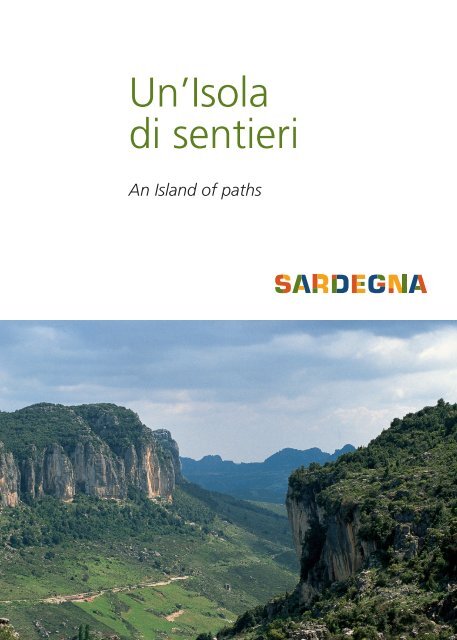
Un'Isola di sentieri - Vacanze in Sardegna - Sito ufficiale della ...
Un'Isola di sentieri - Vacanze in Sardegna - Sito ufficiale della ...
Un'Isola di sentieri - Vacanze in Sardegna - Sito ufficiale della ...

Create successful ePaper yourself
Turn your PDF publications into a flip-book with our unique Google optimized e-Paper software.
Un’Isola<br />
<strong>di</strong> <strong>sentieri</strong><br />
An Island of paths
76 it<strong>in</strong>erari<br />
per il trekk<strong>in</strong>g<br />
<strong>in</strong> <strong>Sardegna</strong><br />
76 hik<strong>in</strong>g trails <strong>in</strong> Sar<strong>di</strong>nia<br />
Su Gorroppu<br />
3
Progetto f<strong>in</strong>anziato dall’Unione Europea<br />
Il POR <strong>Sardegna</strong> 2000-2006 (Mis. 4.14b) per <strong>in</strong>terventi strutturali nello<br />
sviluppo turistico e rurale, si prefigge <strong>di</strong> accrescere e promuovere lo<br />
sviluppo culturale e turistico del territorio sardo con il preciso scopo <strong>di</strong><br />
preservare le risorse naturali e gli ecosistemi e <strong>di</strong> dare impulso al livello<br />
occupazionale. In <strong>di</strong>verse zone <strong>della</strong> <strong>Sardegna</strong> sono stati creati it<strong>in</strong>erari<br />
che mettono <strong>in</strong> relazione fra loro tesori naturali e biologici come alberi<br />
monumentali, punti panoramici e elementi dei contesti culturali del<br />
Me<strong>di</strong>terraneo.<br />
Foto <strong>di</strong> copert<strong>in</strong>a:<br />
Ogliastra, paesaggio dei<br />
tonneri<br />
Front cover picture:<br />
Ogliastra, Tonneri’s<br />
landscape<br />
Foto ultima <strong>di</strong> copert<strong>in</strong>a:<br />
Gennargentu, neve a<br />
Bruncu Sp<strong>in</strong>a<br />
Back cover picture:<br />
Gennargentu, Bruncu<br />
Sp<strong>in</strong>a peak covered<br />
with snow<br />
Tutte le carte dei <strong>sentieri</strong><br />
sono reperibili presso<br />
l’ Ente Foreste<br />
<strong>della</strong> <strong>Sardegna</strong><br />
viale Luigi Merello, 86<br />
09123 Cagliari,<br />
tel. +39 070 27991,<br />
o scaricabili dal sito<br />
www.sardegnaforeste.it<br />
You can collect<br />
all maps from:<br />
viale Luigi Merello, 86<br />
09123 Cagliari,<br />
tel. +39 070 27991,<br />
it is also possible<br />
to download<br />
the maps from<br />
www.sardegnaforeste.it<br />
A project funded by the European Union<br />
The Regional Operational Programme 2000-2006 (ROP Sar<strong>di</strong>nia,<br />
Measure 4.14b) cover<strong>in</strong>g structural actions for tourist and rural<br />
development, aims at foster<strong>in</strong>g the island’s cultural and tourist<br />
development <strong>in</strong> order to protect natural resources and habitats and<br />
boost employment. In various areas of Sar<strong>di</strong>nia, nature trails have been<br />
mapped, l<strong>in</strong>k<strong>in</strong>g natural and biological treasures <strong>in</strong>clu<strong>di</strong>ng monumental<br />
trees, panoramic viewpo<strong>in</strong>ts and sites belong<strong>in</strong>g to the Me<strong>di</strong>terranean<br />
cultural heritage.<br />
viale Luigi Merello, 86 - 09123 Cagliari<br />
Tel. +39 (0)70 27991, fax +39 (0)70 272086<br />
<strong>in</strong>fo@enteforestesardegna.it - www.sardegnaforeste.it<br />
® 2008 Regione Autonoma <strong>della</strong> <strong>Sardegna</strong><br />
Realizzazione a cura dell’Ente Foreste <strong>della</strong> <strong>Sardegna</strong><br />
Immag<strong>in</strong>i: Ente Foreste <strong>della</strong> <strong>Sardegna</strong>, Cocco e Saba, Horus Film s.r.l.<br />
L’Ente Foreste <strong>della</strong> <strong>Sardegna</strong> pubblica i dati qui elencati al solo scopo<br />
<strong>di</strong>vulgativo, per cui decl<strong>in</strong>a ogni responsabilità da possibili errori <strong>di</strong> stampa o da<br />
<strong>in</strong>volontarie omissioni.<br />
The Sar<strong>di</strong>nian Forestry Agency has published the <strong>in</strong>formation conta<strong>in</strong>ed here<strong>in</strong><br />
for <strong>in</strong>formation purposes only, and cannot accept liability of any k<strong>in</strong>d for any<br />
pr<strong>in</strong>t<strong>in</strong>g errors or <strong>in</strong>voluntary omissions..<br />
4
Per scoprire una terra bisogna percorrerla passo passo<br />
L’Ente Foreste <strong>della</strong> <strong>Sardegna</strong> presenta una nuova opera e<strong>di</strong>toriale,<br />
composta da 12 mappe per un totale <strong>di</strong> 76 <strong>sentieri</strong>, con l’obiettivo<br />
<strong>di</strong> promuovere la valorizzazione ecologica e sociale del patrimonio<br />
naturale e culturale.<br />
L’<strong>in</strong>iziativa e<strong>di</strong>toriale denom<strong>in</strong>ata “Un’Isola <strong>di</strong> <strong>sentieri</strong>” è parte<br />
<strong>in</strong>tegrante del POR <strong>Sardegna</strong> 2000-2006 (mis. 4.14b) per <strong>in</strong>terventi<br />
strutturali mirati allo sviluppo turistico e rurale. Il Programma si prefigge<br />
<strong>di</strong> migliorare e accrescere le potenzialità turistiche e culturali del<br />
territorio sardo, preservando le risorse naturali e gli ecosistemi, e <strong>di</strong><br />
migliorare il livello occupazionale. Lo sviluppo <strong>della</strong> <strong>Sardegna</strong> procede<br />
<strong>in</strong>fatti su due fronti che simboleggiano la dualità del territorio sardo:<br />
le zone costiere, caratterizzate da un turismo <strong>di</strong> massa, e le zone<br />
<strong>in</strong>terne che sono state co<strong>in</strong>volte <strong>in</strong> una sorta <strong>di</strong> cambiamento turistico.<br />
Un cambiamento che mira a riconoscere il valore del patrimonio<br />
antropologico e ambientale dei paesi sar<strong>di</strong>.<br />
“Un’Isola <strong>di</strong> <strong>sentieri</strong>” nasce dall’idea che i paesi e i loro territori<br />
siano luoghi importanti per sviluppare <strong>in</strong>iziative culturali, turistiche,<br />
ecologiche e sportive e che la scarsa antropizzazione nei loro territori<br />
abbia <strong>in</strong> qualche modo preservato tutte quelle caratteristiche naturali e<br />
culturali ora considerate come peculiari.<br />
Grazie ai 76 <strong>sentieri</strong>, l’escursionista, l’appassionato o il semplice curioso<br />
potranno constatare che il “profilo” <strong>della</strong> <strong>Sardegna</strong>, lungi dall’essere<br />
solo quello relativo alla costa e alle spiagge, assume anche i contorni<br />
delle valli, delle coll<strong>in</strong>e e dei piccoli paesi pieni <strong>di</strong> storia, usi e leggende.<br />
La <strong>Sardegna</strong> mostra se stessa come un cont<strong>in</strong>ente caratterizzato non<br />
solo dalle bellissime spiagge, ma anche dalla presenza <strong>di</strong> <strong>di</strong>fferenti<br />
specie arboree e faunistiche come quelle appartenenti alla Macchia<br />
me<strong>di</strong>terranea, un’area dom<strong>in</strong>ata dalla presenza <strong>di</strong> varie tipologie <strong>di</strong><br />
arbusti come il cisto, un piccolo arbusto <strong>della</strong> famiglia delle Cistacee, il<br />
mirto, utilizzato per produrre il famoso liquore, il corbezzolo, il leccio e<br />
il lentisco. Il territorio da anche ospitalità a un’ampia congerie <strong>di</strong> specie<br />
animali come, solo per citarne alcuni, il muflone, la volpe, l’aquila reale<br />
e altri numerosi uccelli selvatici.<br />
5
L’<strong>in</strong>iziativa dell’Ente Foreste <strong>della</strong> <strong>Sardegna</strong> si caratterizza dunque per<br />
l’obiettivo f<strong>in</strong>ale <strong>di</strong> recuperare i vecchi camm<strong>in</strong>amenti, <strong>di</strong> migliorare<br />
la sicurezza sui tracciati, <strong>di</strong> implementare il turismo sostenibile e <strong>di</strong><br />
realizzare nuovi cartelli, segnali e punti <strong>di</strong> ristoro per i turisti.<br />
Le tematiche che caratterizzano i percorsi <strong>in</strong> maniera evidente sono:<br />
Temi naturalistico-biologici<br />
percorsi che uniscono e raccordano emergenze <strong>di</strong> carattere naturalistico<br />
e biologico, come alberi monumentali, punti <strong>di</strong> osservazione, specie<br />
protette e giar<strong>di</strong>ni botanici.<br />
Temi antropologici<br />
percorsi legati a particolari elementi dei paesaggi culturali del<br />
Me<strong>di</strong>terraneo, quali quelli degli antichi mestieri (carbonai, pastori<br />
erranti), delle architetture (chiese campestri, architetture rurali<br />
tra<strong>di</strong>zionali) e dei paesaggi rurali (percepibili ad esempio dalle vedette).<br />
Ogni mappa presenta due lati, un lato con la sezione cartografica e<br />
l’altro con brevi descrizioni dei territori e le loro caratteristiche artistiche<br />
e culturali.<br />
To <strong>di</strong>scover a land you need to cross it step by step<br />
The Sar<strong>di</strong>nian Forestry Agency is pleased to publish this guide book,<br />
compris<strong>in</strong>g 12 tourist maps for a total of 76 walk<strong>in</strong>g and hik<strong>in</strong>g trails,<br />
with the aim of enhanc<strong>in</strong>g our Region’s outstan<strong>di</strong>ng natural and<br />
cultural heritage.<br />
This publication entitled “An Island of Paths” is funded by the Regional<br />
Operational Programme 2000-2006 (ROP Sar<strong>di</strong>nia, Measure 4.14b)<br />
cover<strong>in</strong>g structural actions for tourist and rural development, and aims<br />
at foster<strong>in</strong>g the island’s cultural and tourist development <strong>in</strong> order to<br />
protect natural resources and habitats and boost employment. In fact,<br />
the development of Sar<strong>di</strong>nia is procee<strong>di</strong>ng on two fronts, mirror<strong>in</strong>g the<br />
twofold nature of the Region’s territory: the coastal areas, targeted by<br />
mass tourism, and the h<strong>in</strong>terland, which is develop<strong>in</strong>g an alternative<br />
type of tourism, focused on the cultural and environmental heritage of<br />
Sar<strong>di</strong>nian villages.<br />
6
”An Island of Paths” focuses on the opportunities for alternative<br />
cultural, nature <strong>di</strong>scovery and outdoor activities offered by these rural<br />
areas marked by small scattered villages and unspoilt habitats, which<br />
have preserved a unique human and natural heritage.<br />
Thanks to these 76 trails, hikers and day-trippers will <strong>di</strong>scover that<br />
the gems of Sar<strong>di</strong>nia are not only its coasts and beaches, but also its<br />
valleys, hills and small villages steeped <strong>in</strong> history, customs and legends.<br />
Sar<strong>di</strong>nia could be likened to a small cont<strong>in</strong>ent, which <strong>in</strong> ad<strong>di</strong>tion to<br />
its enchant<strong>in</strong>g beaches also boasts a unique heritage of plant life , <strong>in</strong><br />
particular Me<strong>di</strong>terranean maquis and scrubland with various shrub and<br />
tree species, such as cistus salvifolius, a small shrub of the rock rose<br />
family, the myrtle, which is used to produce an aromatic liqueur, the<br />
strawberry tree, the cork oak and the pistacia lentiscus. Sar<strong>di</strong>nia is also<br />
home to rich and varied wildlife <strong>in</strong>clu<strong>di</strong>ng, to mention just a few, the<br />
fox, the mouflon, the hare, the marten, the Sar<strong>di</strong>nian red deer and<br />
several species of endemic birds.<br />
The objective of the Sar<strong>di</strong>nian Forestry Agency is to restore the old<br />
routes, ma<strong>in</strong>ta<strong>in</strong> the trails to ensure their safety, promote susta<strong>in</strong>able<br />
tourism and equip hik<strong>in</strong>g routes with signs, <strong>in</strong><strong>di</strong>cations and rest areas<br />
for walkers.<br />
The 12 maps focus on two ma<strong>in</strong> themes:<br />
Natural heritage<br />
Nature trails lea<strong>di</strong>ng to the <strong>di</strong>scovery of natural treasures, such as<br />
monumental trees, panoramic viewpo<strong>in</strong>ts, protected species and<br />
botanical gardens.<br />
Cultural heritage<br />
Routes for <strong>di</strong>scover<strong>in</strong>g the Me<strong>di</strong>terranean cultural landscape, <strong>in</strong>clu<strong>di</strong>ng<br />
the traces of old crafts (charcoal burners and shepherds), the built<br />
heritage (country churches, rural buil<strong>di</strong>ngs and sheepfolds) and rural<br />
landscapes (which can be appreciated from the lookout po<strong>in</strong>ts.<br />
Each map has two sides, one with the maps, the other with brief<br />
descriptions of the areas and their artistic and cultural features.<br />
7
1. Baronie<br />
Il territorio<br />
La cart<strong>in</strong>a <strong>di</strong> questo<br />
territorio è reperibile<br />
presso:<br />
Comune <strong>di</strong> Lula<br />
Via dei Mille, 5<br />
Lula (NU)<br />
Comune <strong>di</strong> Lodè<br />
C.so Villanova, 10<br />
Lodè (NU)<br />
Contatti per <strong>in</strong>formazioni:<br />
Comune <strong>di</strong> Lula<br />
Tel. + 39 0784 416427<br />
Comune <strong>di</strong> Lodè<br />
Tel. + 39 0784 898018<br />
Il territorio delle Baronie spazia dalla catena calcarea del Montalbo s<strong>in</strong>o<br />
al massiccio del Tuttavista, <strong>in</strong> un’area caratterizzata da corsi d’acqua<br />
come l’Isalle e il Cedr<strong>in</strong>o e vaste pianure alluvionali. In questo contesto<br />
il Montalbo riveste un ruolo <strong>di</strong> fondamentale importanza dal punto<br />
<strong>di</strong> vista naturalistico: <strong>in</strong>fatti esso per le sue caratteristiche e per il suo<br />
stato <strong>di</strong> conservazione, ospita numerose specie <strong>di</strong> flora e fauna rare,<br />
endemiche o <strong>di</strong> <strong>in</strong>teresse biogeografico; tra queste ricor<strong>di</strong>amo la<br />
Santol<strong>in</strong>a corsica, la Lactuca longidentata, il geotritone del Montalbo,<br />
il gracchio corall<strong>in</strong>o, l’aquila reale e il muflone. Lungo i <strong>sentieri</strong> è<br />
possibile <strong>in</strong>oltre imbattersi <strong>in</strong> piccole colonie <strong>di</strong> mufloni, osservare<br />
i segni <strong>della</strong> presenza dei carbonai e sostare presso gli antichi ovili<br />
(p<strong>in</strong>nettos).<br />
Come arrivare<br />
Da Nuoro si prende la SS 131 d.c.n. verso Olbia. Raggiunto il bivio <strong>di</strong><br />
Lula, se si prosegue verso il paese, si percorre la SP 3 e si trovano gli<br />
<strong>in</strong>gressi per i <strong>sentieri</strong> dal versante <strong>di</strong> Lodè; se dal bivio si procede lungo<br />
la SP 45, si trova l’<strong>in</strong>gresso ai <strong>sentieri</strong> dal versante <strong>di</strong> Lula.<br />
8
A destra:<br />
Punta Ferulargiu<br />
On the right:<br />
Punta Ferulargiu<br />
The territory<br />
You can collect a map of<br />
this area from:<br />
Municipality of Lula,<br />
Via dei Mille, 5 - Lula (NU)<br />
Municipality of Lodè, C.so<br />
Villanova, 10 - Lodè (NU)<br />
Contacts for further<br />
<strong>in</strong>formation:<br />
Municipality of Lula<br />
Tel. +39 0784 416427<br />
Municipality of Lodè<br />
Tel. +39 0784 898018<br />
A s<strong>in</strong>istra:<br />
Cuile Ortorutta,<br />
piccola area <strong>di</strong> sosta<br />
On the left:<br />
Cuile Ortorutta,<br />
Small picnic area<br />
The territory of the Baronie runs from limestone cha<strong>in</strong> of Monte Albo<br />
to the massif of Tuttavista, an area marked by streams and rivers such<br />
as the Isalle and the Cedr<strong>in</strong>o and vast alluvial pla<strong>in</strong>s. The Monte Albo<br />
range <strong>in</strong> particular is an area of great natural <strong>in</strong>terest: thanks to its<br />
environmental characteristics and good conservation status, it is home<br />
to numerous animal and plant species, either rare, endemic or of<br />
bio-geographical <strong>in</strong>terest. Here we should mention Santol<strong>in</strong>a corsica,<br />
Lactuca longidentata, the Monte Albo cave salamander, the red-billed<br />
chough, the golden eagle and the mouflon. Along the paths it is<br />
possible to come across small groups of mouflon, f<strong>in</strong>d old charcoal pits<br />
and make a stop at the old sheepfolds (p<strong>in</strong>nettos).<br />
How to get there<br />
From Nuoro, take highway 131 d.c.n. <strong>in</strong> the <strong>di</strong>rection of Olbia. At<br />
the turn<strong>in</strong>g for the town of Lula, head towards the town along SP 3<br />
and you will f<strong>in</strong>d the entrance to the nature trails on the Lodè side of<br />
the mounta<strong>in</strong>; alternatively, if at the turn<strong>in</strong>g you proceed <strong>in</strong> the other<br />
<strong>di</strong>rection along SP 45, you will f<strong>in</strong>d the entrance to the trails from the<br />
Lula side.<br />
9
2. Goceano<br />
Il territorio<br />
Il territorio del Goceano è un’area prevalentemente montuosa ubicata<br />
fra il Monte Acuto e i territori <strong>della</strong> Barbagia e del Margh<strong>in</strong>e.<br />
É caratterizzato dal rilievo del Monte Rasu, dal fiume Tirso e dai suoi<br />
affluenti che ospitano una grande varietà <strong>di</strong> uccelli acquatici. Nell’area<br />
sono presenti le Foreste Demaniali <strong>di</strong> “Fiorent<strong>in</strong>i” e “Anela”, tra le<br />
più antiche foreste demaniali <strong>della</strong> <strong>Sardegna</strong>. Di grande <strong>in</strong>teresse<br />
paesaggistico e naturalistico sono le località “Sa Fraigada” e “Sa<br />
Pruna”, dove si trova una Tomba dei Giganti, e “Monte Unturzu”,<br />
il cui toponimo ricorda la passata presenza dell’avvoltoio grifone.<br />
La cart<strong>in</strong>a <strong>di</strong> questo<br />
territorio è reperibile<br />
presso:<br />
Ente Foreste <strong>della</strong><br />
<strong>Sardegna</strong> via Roma, 62<br />
Sassari<br />
Centro <strong>di</strong> cantiere<br />
Fiorent<strong>in</strong>i<br />
Comune <strong>di</strong> Bultei via IV<br />
Novembre Bultei (SS)<br />
Come arrivare<br />
Da Nuoro prendere SS 131 d.c.n. <strong>in</strong> <strong>di</strong>rezione Macomer-Sassari,<br />
seguire la SS 129 al bivio per Bottidda girare a destra e proseguire f<strong>in</strong>o<br />
all’<strong>in</strong>crocio con la strada a scorrimento veloce. Proseguire f<strong>in</strong>o a Bultei,<br />
attraversare il centro abitato, prendere la strada prov<strong>in</strong>ciale Bultei<br />
-Ozieri (SP 36) ed al Km 18 si arriva alla caserma forestale Fiorent<strong>in</strong>i.<br />
Contatti per <strong>in</strong>formazioni:<br />
Ente Foreste<br />
<strong>della</strong> <strong>Sardegna</strong><br />
Centro del Complesso<br />
Monte Pisanu<br />
Tel. +39 079 791253<br />
Centro <strong>di</strong> Cantiere<br />
Fiorent<strong>in</strong>i<br />
Tel. + 39 079 791122<br />
10
A destra:<br />
Monte Pisanu, sughera<br />
On the right:<br />
A cork oak<br />
The territory<br />
You can collect a map<br />
of this area from:<br />
Sar<strong>di</strong>nian Forestry Agency<br />
via Roma, 62 Sassari<br />
Fiorent<strong>in</strong>i Station<br />
Municipality of Bultei via<br />
IV Novembre Bultei (SS)<br />
Contacts for further<br />
<strong>in</strong>formation:<br />
Monte Pisanu Station<br />
Tel. +39 079 791253<br />
Fiorent<strong>in</strong>i Station<br />
Tel. + 39 079 791122<br />
Goceano is a mostly mounta<strong>in</strong>ous area ly<strong>in</strong>g between Monte Acuto<br />
and the territories of Barbagia and Margh<strong>in</strong>e. The landscape is marked<br />
by Monte Rasu and by the river Tirso and its tributaries, home to a large<br />
variety of water birds. This area also <strong>in</strong>cludes the “Goceano” (Fiorent<strong>in</strong>i<br />
and Anela) Regional Forest, one of the oldest State forests <strong>in</strong> Sar<strong>di</strong>nia.<br />
Of great landscape and natural <strong>in</strong>terest are the “Sa Fraigada” and “Sa<br />
Pruna” areas, the latter with a Giants’ tomb (megalithic grave), and<br />
“Monte Unturzu”, whose name recalls the past presence of the griffon<br />
vulture.<br />
How to get there<br />
From Nuoro take SS 131 d.c.n. towards Macomer-Sassari, then follow<br />
SS 129; at the turn<strong>in</strong>g for Bottidda turn right and drive on until you<br />
reach the ma<strong>in</strong> road. Cont<strong>in</strong>ue to Bultei, drive through the village,<br />
take the Bultei-Ozieri road (SP 36) and after 18 km you will reach the<br />
Forestry Agency Station at Fiorent<strong>in</strong>i.<br />
A s<strong>in</strong>istra:<br />
Tomba <strong>di</strong> Giganti<br />
<strong>di</strong> Sas Presones<br />
On the left:<br />
The Giants’ grave of<br />
Sas Presones<br />
11
3. Guilcer Barigadu<br />
Mandrolisai<br />
Il territorio<br />
La cart<strong>in</strong>a <strong>di</strong> questo<br />
territorio è reperibile<br />
presso:<br />
Comune <strong>di</strong> Se<strong>di</strong>lo, Piazza<br />
S. Giovanni 09076 Se<strong>di</strong>lo<br />
Contatti per <strong>in</strong>formazioni:<br />
Comune <strong>di</strong> Se<strong>di</strong>lo:<br />
Tel. +39 0785 560033<br />
+39 0785 560035<br />
Paleotur 95 Società<br />
Coop. A.r.l., Località Losa<br />
Abbasanta<br />
Tel. + 39 0785 52302<br />
e Cell. + 39 329 7260732<br />
Ente Foreste<br />
<strong>della</strong> <strong>Sardegna</strong><br />
Servizio Territoriale<br />
<strong>di</strong> Oristano<br />
Tel. +39 0783 34341<br />
L’area territoriale denom<strong>in</strong>ata Guilcer situata <strong>in</strong> una porzione centrale<br />
dell’isola è da secoli crocevia <strong>di</strong> attività commerciali. Si tratta <strong>di</strong> un<br />
altopiano basaltico comprendente la pianura alluvionale del fiume<br />
Tirso, <strong>in</strong>teressata per gran parte dall’<strong>in</strong>vaso artificiale del Lago Omodeo.<br />
L’antico territorio del Barigadu è ubicato a sud del Lago Omodeo ed è<br />
caratterizzato dalla presenza delle riserve naturali <strong>di</strong> Assai e <strong>di</strong> Monte<br />
Santa Vittoria, situate fra i paesi <strong>di</strong> Neoneli e Nughedu. Il paesaggio<br />
è caratterizzato dalla macchia me<strong>di</strong>terranea. Nel Mandrolisai sono<br />
presenti ampi pascoli, sugherete, boschi <strong>di</strong> castagno e numerosi<br />
vigneti. La produzione <strong>di</strong> v<strong>in</strong>i rappresenta per il territorio una delle più<br />
importanti risorse economiche.<br />
Come arrivare<br />
Per chi proviene da Sassari e/o da Cagliari, dalla strada statale 131,<br />
<strong>in</strong> prossimità del nuraghe Losa <strong>di</strong> Abbasanta, si deve procedere <strong>in</strong><br />
<strong>di</strong>rezione Nuoro, e raggiungere il centro abitato <strong>di</strong> Se<strong>di</strong>lo, dal quale<br />
hanno <strong>in</strong>izio i <strong>sentieri</strong> del Guilcer, Barigadu e Mandrolisai.<br />
12
A destra:<br />
Lago Omodeo,<br />
panoramica<br />
On the right:<br />
Omodeo Lake,<br />
panorama<br />
The territory<br />
You can collect a map<br />
of this area from:<br />
Municipality of Se<strong>di</strong>lo:<br />
Piazza S. Giovanni 09076<br />
Se<strong>di</strong>lo<br />
Contacts for further<br />
<strong>in</strong>formation:<br />
Municipality of Se<strong>di</strong>lo:<br />
Tel. +39 0785 560033<br />
+39 0785 560035<br />
Paleotur 95 Società<br />
Coop. A.r.l., Località Losa<br />
Abbasanta<br />
Tel. + 39 0785 52302<br />
e Cell. + 39 329 7260732<br />
Sar<strong>di</strong>nian Forestry Agency,<br />
Oristano Branch<br />
Tel. + 39 0783 34341<br />
Thanks to its central location on the island the area known as Guilcer<br />
has for centuries been a crossroads of trade. It consists of a basalt<br />
plateau and <strong>in</strong>cludes the alluvial pla<strong>in</strong> of the river Tirso, now mostly<br />
submerged by an artificial reservoir, Lake Omodeo. The ancient territory<br />
of Barigadu lies south of Lake Omodeo and <strong>in</strong>cludes the nature reserves<br />
of Assai and Monte Santa Vittoria, between the towns of Neoneli<br />
and Nughedu. The landscape is rich <strong>in</strong> Me<strong>di</strong>terranean scrub. In the<br />
Mandrolisai area we f<strong>in</strong>d extensive pasturelands, cork tree forests,<br />
chestnut woods and many v<strong>in</strong>eyards. W<strong>in</strong>emak<strong>in</strong>g is one of the ma<strong>in</strong><br />
activities of this area.<br />
How to get there<br />
For travellers com<strong>in</strong>g from Sassari and/or Cagliari, on the 131 ma<strong>in</strong><br />
road, take the turn<strong>in</strong>g for Nuoro <strong>in</strong> the vic<strong>in</strong>ity of the Losa nuraghe at<br />
Abbasanta, then follow the signs for the town of Se<strong>di</strong>lo, from which<br />
the nature trails of Guilcer, Barigadu and Mandrolisai start.<br />
A s<strong>in</strong>istra:<br />
Carbonaia <strong>in</strong> fase<br />
<strong>di</strong> allestimento<br />
On the left:<br />
A charcoal pile<br />
13
4. Supramonte<br />
Ogliastr<strong>in</strong>o<br />
Il territorio<br />
La cart<strong>in</strong>a <strong>di</strong> questo<br />
territorio è reperibile<br />
presso:<br />
Comune <strong>di</strong> Urzulei, via<br />
Grazia Deledda, 23 (OG)<br />
Contatti per <strong>in</strong>formazioni:<br />
Comune <strong>di</strong> Urzulei<br />
Tel. + 39 0782 649023<br />
Ente Foreste <strong>della</strong><br />
<strong>Sardegna</strong>, UGB Silana<br />
Tel. + 39 320 4331248<br />
Il Supramonte è un altopiano calcareo dall’estensione <strong>di</strong> 35.000 Ha.<br />
Gli eventi geologici e l’erosione hanno creato <strong>in</strong> milioni <strong>di</strong> anni la<br />
morfologia aspra e selvaggia del territorio, caratterizzato da crepacci,<br />
dol<strong>in</strong>e, grotte (Su Palu, S’edera e altre) e canyon detti codule. Qui<br />
vivono il rarissimo ghiro sardo, il geotritone, l’aquila reale e il muflone.<br />
Solo qui è possibile trovare il Ramno <strong>di</strong> <strong>Sardegna</strong>, unica specie arborea<br />
esclusiva dell’Isola <strong>in</strong>sieme a numerose altre piante endemiche e rare.<br />
Sparsi nel territorio vi sono i Cuiles o Barracos, strutture <strong>di</strong> pietra e<br />
legno utilizzati per secoli dai pastori come rifugi e ovili. Numerose le<br />
testimonianze <strong>di</strong> epoca nuragica tra cui le tombe dei giganti <strong>di</strong> Fennau<br />
e il nuraghe Gorroppu.<br />
Come arrivare<br />
Da Arbatax si arriva ad Urzulei seguendo la strada <strong>in</strong> <strong>di</strong>rezione Lotzorai<br />
e svoltando al bivio per Urzulei/Talana. Da Olbia si percorre la SS<br />
125 verso Nuoro, proseguendo per Dorgali, f<strong>in</strong>o ad arrivare al bivio<br />
<strong>di</strong> “Giustizieri”. Da qui dopo 1 Km si svolta a destra e dopo 5 Km si<br />
giunge a Urzulei.<br />
14
A destra:<br />
Codula de Luna,<br />
panoramica<br />
O the right:<br />
Codula de Luna,<br />
panorama<br />
The territory<br />
You can collect a map<br />
of this area from:<br />
Municipality of Urzulei,<br />
via Grazia Deledda, 23<br />
Urzulei (OG)<br />
Contacts for further<br />
<strong>in</strong>formation:<br />
Municipality of Urzulei<br />
Tel. +39 0782 649023<br />
Sar<strong>di</strong>nian Forestry Agency,<br />
UGB Silana<br />
Tel. +39 320 4331248<br />
The Supramonte is a limestone tableland stretch<strong>in</strong>g over 35,000<br />
hectares. Over millions of years, geological events and weather<strong>in</strong>g<br />
processes have shaped this area’s rugged, wild landscape, rich <strong>in</strong><br />
crevasses, s<strong>in</strong>k-holes, caves (Su Palu, S’edera and many others) and<br />
canyons known as codule. This area is home to the extremely rare<br />
Sar<strong>di</strong>nian dormouse, the Sar<strong>di</strong>nian cave salamander, the golden eagle<br />
and the mouflon. Only here are visitors able to f<strong>in</strong>d the Sar<strong>di</strong>nian<br />
buckthorn (Rhammus), the only tree species exclusive to the island, as<br />
well as many other endemic and rare plants. Scattered over the territory<br />
are the Cuiles or Barracos, stone and wooden structures used for<br />
centuries by the shepherds as shelters and sheepfolds. There are many<br />
rema<strong>in</strong>s from Nuraghic times <strong>in</strong>clu<strong>di</strong>ng a Giants’ tomb at Fennau and<br />
the Gorroppu nuraghe.<br />
How to get there<br />
A s<strong>in</strong>istra:<br />
Cala Luna,<br />
panoramica<br />
On the left:<br />
Cala Luna, panorama<br />
If travell<strong>in</strong>g from Arbatax, take the road towards Lotzorai and turn off<br />
for Urzulei at the Urzulei/Talana turn<strong>in</strong>g. If you are driv<strong>in</strong>g from Olbia,<br />
take SS 125 towards Nuoro, then drive on towards Dorgali, until you<br />
reach the “Giustizieri” turn<strong>in</strong>g. After 1 km, make a turn right and after<br />
5 km you will reach Urzulei.<br />
15
5. Gennargentu<br />
Il territorio<br />
La cart<strong>in</strong>a <strong>di</strong> questo<br />
territorio è reperibile<br />
presso:<br />
Ente Foreste <strong>della</strong><br />
<strong>Sardegna</strong>, Servizio<br />
Territoriale Nuoro<br />
Via Deffenu 7/9<br />
Contatti per <strong>in</strong>formazioni:<br />
Ente Foreste<br />
<strong>della</strong> <strong>Sardegna</strong><br />
Servizio Territoriale Nuoro<br />
Tel. + 39 0784 228200<br />
Il Gennargentu è un massiccio montuoso che ospita le vette più elevate<br />
dell’Isola (Punta La Marmora 1834 m e Bruncu Sp<strong>in</strong>a 1828 m). Da qui<br />
si gode <strong>di</strong> un panorama che spazia su tutta l’Isola. L’area è <strong>di</strong> grande<br />
pregio per la presenza <strong>di</strong> habitat e specie endemiche e rare. Qui è<br />
possibile vedere l’aquila reale o imbattersi <strong>in</strong> gruppi <strong>di</strong> mufloni. La<br />
vegetazione è costituita da prati, garighe e macchie, presenti anche fitti<br />
ontaneti e roverelle monumentali. Chi percorre i <strong>sentieri</strong> potrà <strong>di</strong>ssetarsi<br />
presso le freschissime sorgenti, ammirare fioriture <strong>di</strong> rara bellezza e un<br />
sorprendente numero <strong>di</strong> <strong>in</strong>setti. Nei fondovalle si trovano gli antichi ovili<br />
a volte ancora <strong>in</strong> uso. Nei paesi è possibile visitare musei, degustare i<br />
prodotti locali e acquistare i manufatti dell’artigianato.<br />
Come arrivare<br />
Da Nuoro si prende la SS 389 verso Lanusei, dopo 20 km si svolta per<br />
Fonni e da qui si prende la SP 7 verso Desulo. Giunti al passo <strong>di</strong> Tascusì<br />
si trovano le <strong>in</strong><strong>di</strong>cazioni per le reti dei <strong>sentieri</strong> <strong>di</strong> Desulo e <strong>di</strong> Tonara.<br />
16
A destra:<br />
Aquila reale con preda<br />
On the right:<br />
Golden eagle with prey<br />
The territory<br />
You can collect a map<br />
of this area from:<br />
Sar<strong>di</strong>nian Forestry Agency,<br />
Nuoro Branch,<br />
Via Deffenu 7/9 - Nuoro<br />
Contacts for further<br />
<strong>in</strong>formation:<br />
Sar<strong>di</strong>nian Forestry Agency,<br />
Nuoro Branch<br />
Tel. +39 0784 228200<br />
A s<strong>in</strong>stra:<br />
Panoramica<br />
del Gennargentu<br />
On the left:<br />
Gennargentu,<br />
panorama<br />
The Gennargentu is a mounta<strong>in</strong> massif which has the highest peaks on<br />
the island (Punta La Marmora 1834 m and Bruncu Sp<strong>in</strong>a 1828 m). From<br />
here, visitors can enjoy a view rang<strong>in</strong>g over the whole island. This area<br />
has great natural value and <strong>in</strong>cludes various habitats with endemic and<br />
rare species. Here it is possible to spot the golden eagle or come across<br />
groups of mouflons. The plant cover consists of meadows, garigue<br />
and shrubland, but there are also thick alder stands and monumental<br />
pubescent oaks. Trekkers can stop and dr<strong>in</strong>k from icy cold spr<strong>in</strong>gs,<br />
and admire flower<strong>in</strong>g plants of extraor<strong>di</strong>nary beauty, as well as a wide<br />
range of <strong>in</strong>sect life. In the valleys below are ancient sheepfolds, some<br />
still <strong>in</strong> use. In the small towns and villages, visitors can browse through<br />
museums, taste the local food and w<strong>in</strong>e products and purchase<br />
tra<strong>di</strong>tional han<strong>di</strong>crafts.<br />
How to get there<br />
From Nuoro take SS 389 <strong>in</strong> the <strong>di</strong>rection of Lanusei. After 20 km take<br />
the turn<strong>in</strong>g for Fonni and then take SP 7 <strong>in</strong> the <strong>di</strong>rection of Desulo.<br />
Once you reach the Tascusì pass, you will f<strong>in</strong>d <strong>di</strong>rections to the<br />
trailheads of Desulo and Tonara.<br />
17
Cala Luna,<br />
veduta panoramica<br />
View of Cala Luna<br />
19
6. Gennargentu<br />
Ogliastr<strong>in</strong>o<br />
Il territorio<br />
La cart<strong>in</strong>a <strong>di</strong> questo<br />
territorio è reperibile<br />
presso:<br />
Ente Foreste<br />
<strong>della</strong> <strong>Sardegna</strong> via Pisc<strong>in</strong>as,<br />
5 Lanusei.<br />
Comune <strong>di</strong> Talana, P.zza<br />
Santa Marta, Talana (OG)<br />
Associazione Turistica<br />
Pro Loco Talana<br />
via Nuoro 17 - Talana (OG)<br />
Sull’orig<strong>in</strong>e del nome Ogliastra esistono due teorie: secondo la prima<br />
esso deriverebbe dalla <strong>di</strong>ffusa presenza dell’Olivastro; per la seconda<br />
<strong>in</strong>vece deriverebbe dall’imponente guglia, “l’Agugliastra”, <strong>di</strong> Pedra<br />
Longa che dom<strong>in</strong>a il mare a nord <strong>di</strong> Santa Maria Navarrese. Si tratta<br />
<strong>di</strong> un territorio perlopiù montuoso compreso tra la costa e le vette<br />
del Gennargentu che appare come un immenso anfiteatro volto al<br />
mare. Il sistema costiero è variegato e comprende falesie a picco sul<br />
mare e splen<strong>di</strong>de spiagge come: Cala Luna, Cala Goloritzè, Orrì, Cea<br />
e Sarrala. I paesaggi dell’<strong>in</strong>terno sono altrettanto ricchi e spaziano dal<br />
Supramonte <strong>di</strong> Baunei ed Urzulei ai boschi e le montagne <strong>di</strong> Talana,<br />
Villagrande, Seui e Ussassai, dal Gennargentu <strong>di</strong> Arzana ai tacchi e le<br />
valli <strong>di</strong> Gairo, Jerzu, Os<strong>in</strong>i e Ulassai.<br />
Come arrivare<br />
Da Tortolì si prende la SS 125 verso Lotzorai, dopo 5 km si svolta per<br />
la SP 56 verso Talana. Giunti al ponte sul Rio Co ‘e Serra si trovano le<br />
<strong>in</strong><strong>di</strong>cazioni per il sentiero <strong>di</strong> Sorber<strong>in</strong>e e per il sentiero dei carbonai.<br />
Contatti per <strong>in</strong>formazioni:<br />
Comune <strong>di</strong> Talana,<br />
P.zza Santa Marta,<br />
Talana (OG)<br />
Tel. + 39 0782 646603<br />
Associazione Turistica<br />
Pro Loco Talana<br />
via Nuoro 17 - Talana (OG)<br />
Tel. + 39 0782 646954<br />
prolocotalana@tiscali.it<br />
Ente Foreste<br />
<strong>della</strong> <strong>Sardegna</strong><br />
via Pisc<strong>in</strong>as, 5 Lanusei<br />
Tel. + 39 0782 490700<br />
20
A destra:<br />
Vista sui monti<br />
d’Ogliastra<br />
On the right:<br />
View of the Ogliastra’s<br />
mounta<strong>in</strong>s<br />
You can collect a map<br />
of this area from:<br />
Sar<strong>di</strong>nian Forestry Agency,<br />
via Pisc<strong>in</strong>as, 5 Lanusei<br />
Municipality of Talana,<br />
P.zza Santa Marta, Talana<br />
(OG)<br />
Tourist Association Pro<br />
Loco Talana, Via Nuoro,<br />
17 - Talana (OG)<br />
Contacts for further<br />
<strong>in</strong>formation:<br />
Municipality of Talana,<br />
P.zza Santa Marta,<br />
Talana (OG)<br />
Tel. +39 0782 646603<br />
Tourist Association Pro<br />
Loco Talana, Via Nuoro,<br />
17, Talana (OG)<br />
Tel. +39 0782 646954<br />
prolocotalana@tiscali.it<br />
Sar<strong>di</strong>nian Forestry Agency,<br />
Via Pisc<strong>in</strong>as, 5, Lanusei<br />
Tel. +39 0782 490700<br />
A s<strong>in</strong>istra:<br />
Sentiero Sorber<strong>in</strong>e<br />
On the left:<br />
Sorber<strong>in</strong>e trail<br />
The territory<br />
There are two theories about the orig<strong>in</strong> of the name Ogliastra: the<br />
first is that it derives from the widespread presence of the wild olive<br />
or oleaster, whereas the other attributes it to the impos<strong>in</strong>g spire, the<br />
“Agugliastra”, of Pedra Longa which looks out over the sea to the<br />
north of Santa Maria Navarrese. Ogliastra is a ma<strong>in</strong>ly mounta<strong>in</strong>ous<br />
territory set between the coast and the peaks of the Gennargentu<br />
massif, form<strong>in</strong>g a great natural amphitheatre fac<strong>in</strong>g towards the sea.<br />
The coast is very varied and <strong>in</strong>cludes cliffs dropp<strong>in</strong>g sheer <strong>in</strong>to the sea<br />
<strong>in</strong>terspersed with splen<strong>di</strong>d beaches such as Cala Luna, Cala Goloritzè,<br />
Orrì, Cea and Sarrala. The landscape of the <strong>in</strong>terior is equally varied,<br />
rang<strong>in</strong>g from the Supramonte highlands of Baunei and Urzulei to the<br />
woods and mounta<strong>in</strong>s of Talana, Villagrande, Seui and Ussassai, from<br />
the Gennargentu of Arzana to the “Tacchi” (limestone rock formations)<br />
and valleys of Gairo, Jerzu, Os<strong>in</strong>i and Ulassai.<br />
How to get there<br />
From Tortolì, take SS 125 <strong>in</strong> the <strong>di</strong>rection of Lotzorai. After 5 km turn<br />
on to SP 56 for Talana. Once you reach the bridge over the Rio Co ‘e<br />
Serra, you will f<strong>in</strong>d <strong>di</strong>rections for the Sorber<strong>in</strong>e trail and the charcoal<br />
burners’ trail.<br />
21
7. Barbagia<br />
Il territorio<br />
La cart<strong>in</strong>a <strong>di</strong> questo<br />
territorio è reperibile<br />
presso:<br />
Ente Foreste<br />
<strong>della</strong> <strong>Sardegna</strong><br />
Servizio Territoriale<br />
<strong>di</strong> Nuoro Via Deffenu 7/9<br />
Contatti per <strong>in</strong>formazioni:<br />
Ente Foreste<br />
<strong>della</strong> <strong>Sardegna</strong><br />
Servizio Territoriale<br />
<strong>di</strong> Nuoro<br />
Tel: + 39 0784 228200<br />
L’area <strong>della</strong> Barbagia-Mandrolisai è caratterizzata dalla totale assenza <strong>di</strong><br />
zone pianeggianti e dalla forte presenza <strong>di</strong> massicci montuosi. La natura<br />
geologica delle rocce conferisce a questi rilievi caratteri <strong>di</strong> suggestiva<br />
bellezza paesaggistica, variando dalla roccia scistosa del Gennargentu<br />
ai torrioni calcarei <strong>della</strong> Barbagia <strong>di</strong> Belvì. Il territorio è noto per le<br />
tra<strong>di</strong>zioni popolari e per la gastronomia che si <strong>di</strong>st<strong>in</strong>gue per gli ottimi<br />
arrosti <strong>di</strong> carne, le seadas e il v<strong>in</strong>o Cannonau. Nei paesi <strong>di</strong> Belvì e Aritzo<br />
si possono apprezzare le caratteristiche abitazioni rurali e osservare<br />
gli artigiani del legno. Inoltre sono presenti importanti monumenti<br />
archeologici quali domus de janas, menhir, dolmen, nuraghi, tombe dei<br />
giganti e resti <strong>di</strong> villaggi nuragici.<br />
Come arrivare<br />
Da Nuoro si prende la SS 389 verso Lanusei. Dopo 20 km si svolta per<br />
Fonni e da qui si prende la SP 7 verso Desulo. Giunti al passo <strong>di</strong> Tascusì<br />
si prosegue per Aritzo dove si trovano le <strong>in</strong><strong>di</strong>cazioni per le reti dei<br />
<strong>sentieri</strong> <strong>di</strong> Aritzo, Belvì e Meana Sardo.<br />
22
A destra:<br />
Tacco Texile<br />
On the right:<br />
Tacco Texile<br />
The territory<br />
You can collect a map<br />
of this area from:<br />
Sar<strong>di</strong>nian Forestry Agency,<br />
Nuoro Branch,<br />
Via Deffenu, 7/9, Nuoro<br />
Contacts for further<br />
<strong>in</strong>formation:<br />
Sar<strong>di</strong>nian Forestry Agency,<br />
Nuoro Branch<br />
Tel. +39 0784 228200<br />
The Barbagia-Mandrolisai area is predom<strong>in</strong>antly mounta<strong>in</strong>ous,<br />
with hardly any level areas. The geological composition of the rock<br />
formations has given rise to a landscape of unique beauty, rang<strong>in</strong>g<br />
from the schist rocks of the Gennargentu to the limestone towers<br />
of the Barbagia <strong>di</strong> Belvì. The territory is well known for its popular<br />
tra<strong>di</strong>tions and gastronomy, <strong>in</strong>clu<strong>di</strong>ng excellent roasted meat, seadas (a<br />
fritter with fresh cheese fill<strong>in</strong>g, dressed with honey) and its excellent<br />
Cannonau red w<strong>in</strong>e. In the small towns of Belvì and Aritzo, visitors can<br />
admire the characteristic village houses and watch the woodcarvers<br />
at work. The countryside is dotted with important archaeological<br />
monuments such as domus de janas, menhirs, dolmens, nuraghi,<br />
giants’ tombs and the rema<strong>in</strong>s of Nuraghic villages.<br />
How to get there<br />
A s<strong>in</strong>istra:<br />
Area attrezzata<br />
<strong>di</strong> Onistri<br />
On the left:<br />
Onistri rest area<br />
From Nuoro take SS 389 <strong>in</strong> the <strong>di</strong>rection of Lanusei. After 20 km, take<br />
the turn<strong>in</strong>g for Fonni and then take SP 7 <strong>in</strong> the <strong>di</strong>rection of Desulo.<br />
When you reach the Tascusì pass, cont<strong>in</strong>ue on for Aritzo where you will<br />
f<strong>in</strong>d <strong>di</strong>rections to the trailheads and trail network of Aritzo, Belvì and<br />
Meana Sardo.<br />
23
8. Sarcidano<br />
Il territorio<br />
La regione del Sarcidano si estende tra la pianura del Campidano<br />
e le montagne <strong>della</strong> Barbagia. Il centro abitato più importante è<br />
Laconi che si contrad<strong>di</strong>st<strong>in</strong>gue, oltre che per le emergenze naturali e<br />
paesaggistiche, per gli <strong>in</strong>se<strong>di</strong>amenti preistorici. Numerosi sono <strong>in</strong>fatti sul<br />
territorio i siti <strong>di</strong> <strong>in</strong>teresse archeologico e nel paese è presente il Museo<br />
dei Menhir Dolmen e Nuraghi. Testimonianza del secolo scorso sono<br />
<strong>in</strong>vece il Castello e il Parco <strong>di</strong> Aymerich ed il ricordo dell’umile frate<br />
Sant’Ignazio da Laconi, santificato da papa Pio XII.<br />
La cart<strong>in</strong>a <strong>di</strong> questo<br />
territorio è reperibile<br />
presso:<br />
Comune <strong>di</strong> Laconi, Piazza<br />
Marconi, 1 - Laconi (OR);<br />
Per <strong>in</strong>formazioni<br />
Comune <strong>di</strong> Laconi,<br />
Tel. + 39 0782 866200<br />
Ente Foreste<br />
<strong>della</strong> <strong>Sardegna</strong>, C. F.<br />
Sarcidano<br />
Tel. + 39 0782 869343.<br />
Come arrivare<br />
Partendo da Oristano, si percorre la SP 35 e si attraversano i centri<br />
abitati <strong>di</strong> Simaxis e Usellus. Qu<strong>in</strong><strong>di</strong> si giunge al quadrivio <strong>di</strong> Escovedu.<br />
Da qui si lascia la strada prov<strong>in</strong>ciale e ci si immette sulla SS 442 che<br />
conduce al paese <strong>di</strong> Laconi. La strada risulta abbastanza scorrevole e si<br />
percorrono i 60 km <strong>in</strong> poco meno <strong>di</strong> un’ora.<br />
24
A destra:<br />
Nuraghe<br />
Genna ‘e Corte<br />
On the right:<br />
Nuraghe<br />
Genna ‘e Corte<br />
The territory<br />
You can collect a map<br />
of this area from:<br />
Municipality of Laconi,<br />
Piazza Marconi, 1 - Laconi<br />
(OR)<br />
Contacts for further<br />
<strong>in</strong>formation:<br />
Municipality of Laconi<br />
Tel. +39 0782 866200<br />
Sar<strong>di</strong>nian Forestry Agency,<br />
C. F. Sarcidano<br />
Tel. +39 0782 869343<br />
A s<strong>in</strong>istra:<br />
Parco Aymerich,<br />
castello<br />
On the left:<br />
Aymerich park,<br />
the castle<br />
The Sarcidano <strong>di</strong>strict stretches between the Campidano pla<strong>in</strong> and the<br />
Barbagia mounta<strong>in</strong>s. Its most important town is Laconi, famous not<br />
only for the beauty of its nature and landscape but also for the many<br />
prehistoric sites scattered <strong>in</strong> the area. The town has a f<strong>in</strong>e Museum of<br />
sculpted Menhirs. Just outside the town are the 19th-century Castle<br />
and Park of the Aymerich family. Laconi was also the hometown of the<br />
Capuch<strong>in</strong> friar Ignatius of Laconi, who was canonized by Pope Pius XII.<br />
How to get there<br />
From Oristano, take SP 35 and drive through the villages of Simaxis<br />
and Usellus. This will br<strong>in</strong>g you to the Escovedu crossroads. From here,<br />
leave the prov<strong>in</strong>cial road and take SS 442 as far as Laconi. This is a<br />
reasonably easy drive and you should cover the 60 km <strong>in</strong> slightly less<br />
than one hour.<br />
25
9. Tacchi<br />
d’Ogliastra<br />
Il territorio<br />
La cart<strong>in</strong>a <strong>di</strong> questo<br />
territorio è reperibile<br />
presso:<br />
Ente Foreste <strong>della</strong><br />
<strong>Sardegna</strong>, Servizio<br />
Territoriale <strong>di</strong> Lanusei, Via<br />
Pisc<strong>in</strong>as n.5 Lanusei (OG)<br />
Comune <strong>di</strong> Ulassai, Via<br />
Garibal<strong>di</strong>, 41 Ulassai (OG)<br />
Comune <strong>di</strong> Os<strong>in</strong>i, Via S.<br />
Lucia, 1 Os<strong>in</strong>i (OG)<br />
I Tacchi d’Ogliastra sono monti calcareo-dolomitici dalla tipica<br />
conformazione che caratterizzano una porzione importante del<br />
territorio ogliastr<strong>in</strong>o. Fra i “Tacchi” è possibile menzionare Perda Liana<br />
(Gairo) poiché uno dei più noti. È possibile ricordare anche il Tacco <strong>di</strong><br />
Monte Tisiddu, il Tacco Arba <strong>di</strong> Ussassai, il Monte Lumburau, il Monte<br />
Arquerì, il Taccu Anguil’e Ferru, Punta Corongiu, il passo <strong>di</strong> San Giorgio<br />
e le grotte <strong>di</strong> Su Marmuri. Sui Tacchi si possono visitare luoghi selvaggi<br />
ed habitat unici, caratterizzati dalla presenza <strong>di</strong> specie animali e vegetali<br />
<strong>di</strong> particolare <strong>in</strong>teresse. Numerosi gli <strong>in</strong>se<strong>di</strong>amenti nuragici, tra cui quelli<br />
<strong>di</strong>: Serbissi, Sanu, Urceni, Mela, Is Cocorronis, Pranu e Su Samuccu.<br />
Nel territorio si conservano le antiche attività agropastorali come<br />
l’allevamento, la viticoltura e l’artigianato.<br />
Come arrivare<br />
Da Lanusei si prende la SS 198 verso Gairo-Seui. Dopo 12 km si<br />
<strong>in</strong>contra Gairo, lo si attraversa e si prosegue sulla SS 198 per altri 5 Km<br />
f<strong>in</strong>o al bivio the porta ai paesi <strong>di</strong> Os<strong>in</strong>i e Ulassai.<br />
Contatti per <strong>in</strong>formazioni:<br />
Ente Foreste <strong>della</strong><br />
<strong>Sardegna</strong>, Servizio<br />
Territoriale <strong>di</strong> Lanusei, Via<br />
Pisc<strong>in</strong>as n.5 Lanusei (OG)<br />
Tel. + 39 0782 490700<br />
26
A destra:<br />
Sentiero Genna Filigi,<br />
Anello <strong>di</strong> Perda Liana<br />
On the right:<br />
Path of Genna Filigi,<br />
Anello <strong>di</strong> Perda Liana<br />
You can collect a map<br />
of this area from:<br />
Sar<strong>di</strong>nian Forestry Agency,<br />
Lanusei Branch,<br />
Via Pisc<strong>in</strong>as, 5 - Lanusei<br />
(OG)<br />
Municipality of Ulassai,<br />
Via Garibal<strong>di</strong>, 41 - Ulassai<br />
(OG) Municipality of Os<strong>in</strong>i,<br />
Via S. Lucia, 1 - Os<strong>in</strong>i (OG)<br />
Contacts for further<br />
<strong>in</strong>formation:<br />
Sar<strong>di</strong>nian Forestry Agency,<br />
Lanusei Branch,<br />
Via Pisc<strong>in</strong>as, 5 - Lanusei<br />
(OG) Tel. +39 0782<br />
490700<br />
The territory<br />
The Tacchi of Ogliastra, impos<strong>in</strong>g dolomitic-limestone outcrops,<br />
characterise the landscape of much of the territory of Ogliastra.<br />
One of the best known is Perda Liana (Gairo), but we should also<br />
mention the Tacco of Monte Tisiddu, Tacco Arba of Ussassai, Monte<br />
Lumburau, Monte Arquerì, Taccu Anguil’e Ferru, Punta Corongiu, the<br />
pass of San Giorgio and the caves of Su Marmuri. The Tacchi preserve<br />
unspoilt nature provi<strong>di</strong>ng unique habitats to a for a rich variety of<br />
wildlife and flora. The area has a number of Nuraghic sites, such as<br />
Serbissi, Sanu, Urceni, Mela, Is Cocorronis, Pranu and Su Samuccu.<br />
The area’s tra<strong>di</strong>tional agro-pastoral economy is still thriv<strong>in</strong>g, the ma<strong>in</strong><br />
activities be<strong>in</strong>g free-range stock rais<strong>in</strong>g, grape grow<strong>in</strong>g and han<strong>di</strong>craft<br />
production.<br />
How to get there<br />
A s<strong>in</strong>istra:<br />
Seui, la vecchia stazione<br />
“Anulù - Montarbu”<br />
On the left:<br />
Seui, the old<br />
“Anulù -Montarbu”<br />
railway station<br />
From Lanusei take SS 198 <strong>in</strong> the <strong>di</strong>rection of Gairo-Seui. After 12 km<br />
you will reach Gairo, drive through it and cont<strong>in</strong>ue along SS 198 for<br />
another 5 km, until the turnoff lea<strong>di</strong>ng until the turn<strong>in</strong>g for<br />
the villages of Os<strong>in</strong>i and Ulassai.<br />
27
10. Barbagia<br />
<strong>di</strong> Seulo<br />
Il territorio<br />
La cart<strong>in</strong>a <strong>di</strong> questo<br />
territorio è reperibile<br />
presso:<br />
Ente Foreste <strong>della</strong><br />
<strong>Sardegna</strong> via Santa<br />
Croce, 20 Sadali.<br />
Ente Foreste <strong>della</strong><br />
<strong>Sardegna</strong> Complesso<br />
Forestale <strong>di</strong> Montarbu<br />
Contatti per <strong>in</strong>formazioni:<br />
Ente Foreste <strong>della</strong><br />
<strong>Sardegna</strong> Sadali:<br />
Tel. +39 0782 59359.<br />
Ente Foreste <strong>della</strong><br />
<strong>Sardegna</strong> Complesso<br />
Forestale <strong>di</strong> Montarbu<br />
Tel. +39 0782 55855<br />
La Barbagia <strong>di</strong> Seulo è un territorio ricco <strong>di</strong> risorse naturali che merita<br />
<strong>di</strong> essere conosciuto ed esplorato. Il territorio è prevalentemente<br />
montuoso e coll<strong>in</strong>are ed è quasi <strong>di</strong>sabitato nelle aree più impervie.<br />
Numerosi sono i fenomeni carsici: grotte, <strong>in</strong>ghiottitoi, cunicoli. Tra<br />
le più note la Grutta de is janas <strong>di</strong> Sadali, considerata tra le più belle<br />
grotte <strong>della</strong> <strong>Sardegna</strong>. L’area riveste un’importanza naturalistica<br />
elevatissima. Ne è un esempio la splen<strong>di</strong>da Foresta demaniale <strong>di</strong><br />
Montarbu un’<strong>in</strong>contam<strong>in</strong>ata oasi ambientale <strong>di</strong> quasi 3000 ha <strong>in</strong> cui<br />
si possono ammirare molte specie endemiche <strong>della</strong> flora e <strong>della</strong> fauna<br />
sarda nonché ampi tratti <strong>di</strong> boschi secolari e alberi monumentali<br />
che si ergono nelle vallate o tra i <strong>di</strong>rupi rocciosi. Luogo ideale per gli<br />
appassionati <strong>di</strong> escursionismo.<br />
Come arrivare<br />
Da Cagliari percorrendo la SS 131 s<strong>in</strong>o al bivio <strong>di</strong> con la SS 128<br />
<strong>di</strong>rezione Senorbì. Si percorre la SS 128 f<strong>in</strong>o al bivio con la SS 198<br />
<strong>di</strong>rezione Sadali-Seui. Dopo 32 km si raggiunge Sadali. Proseguendo<br />
per 9 km si arriva a Seui; superato il paese dopo circa 4 km si svolta a<br />
s<strong>in</strong>istra e seguendo i cartelli <strong>in</strong><strong>di</strong>catori si giunge alla sede del Complesso<br />
Forestale <strong>di</strong> Montarbu.<br />
28
A destra:<br />
Seulo, cascata <strong>di</strong> Su<br />
stampu e su Turrunu<br />
On the right:<br />
Seulo, water fall<br />
of Su stampu e su<br />
Turrunu<br />
You can collect a map<br />
of this area from:<br />
Sar<strong>di</strong>nian Forestry Agency,<br />
via Santa Croce, 20<br />
Sadali (CA)<br />
Ente Foreste <strong>della</strong><br />
<strong>Sardegna</strong> C. F. Montarbu<br />
Contacts for further<br />
<strong>in</strong>formation:<br />
Sar<strong>di</strong>nian Forestry<br />
Agency - Sadali<br />
Tel. +39 070 59359<br />
Ente Foreste <strong>della</strong><br />
<strong>Sardegna</strong> C. F. Montarbu<br />
Tel. +39 0782 55855<br />
The territory<br />
The Barbagia of Seulo is a territory with a rich natural heritage to<br />
explore and <strong>di</strong>scover. It is ma<strong>in</strong>ly mounta<strong>in</strong>ous and hilly and its most<br />
rugged areas are almost un<strong>in</strong>habited. There are numerous karst<br />
formations: caves, s<strong>in</strong>kholes, underground passages. Amongst the<br />
best known is the Grutta de is janas at Sadali, considered one of the<br />
most beautiful caves <strong>in</strong> Sar<strong>di</strong>nia. This area is of outstan<strong>di</strong>ng natural<br />
value, s<strong>in</strong>ce its geographical isolation led to the development of a large<br />
number of species exclusive to Sar<strong>di</strong>nia. Its plant life <strong>in</strong>cludes endemic<br />
and rare species, as well as large stretches of secular woodland and<br />
monumental trees to be found <strong>in</strong> the valleys and rav<strong>in</strong>es. Thanks to its<br />
varied habitats, the area is home to a rich cross section of the island’s<br />
wildlife.<br />
How to get there<br />
A s<strong>in</strong>istra:<br />
Foresta Cannas,<br />
sentiero<br />
On the left:<br />
Cannas forest, a trail<br />
From Cagliari take SS 131 as far as the turn<strong>in</strong>g for SS 128 <strong>in</strong> the<br />
<strong>di</strong>rection of Senorbì. Cont<strong>in</strong>ue along SS 128 as far as the <strong>in</strong>tersection<br />
with SS 198 and follow the <strong>di</strong>rections for Sadali-Seui. After 32 km you<br />
will reach Sadali. Estimated time: 1 hr 37 m<strong>in</strong>.<br />
29
11. Iglesiente<br />
Il territorio<br />
Le <strong>in</strong>formazioni e<br />
le cart<strong>in</strong>e <strong>di</strong> questo<br />
territorio sono reperibili<br />
presso:<br />
Cantiere forestale<br />
“Portixeddu”<br />
loc. Portixeddu , SP 83<br />
Buggerru (CI)<br />
Tel. + 39 0781 54934;<br />
Complesso Forestale<br />
“Marganai” Iglesias<br />
Tel. + 39 0781 20068;<br />
Comune <strong>di</strong> Buggerru<br />
Via Roma, 59 (CI)<br />
Tel. + 39 0781 54104;<br />
“Buggerru Ospitalità” via<br />
Mar<strong>in</strong>a, 37<br />
“Locali ex Centrale”<br />
Tel. + 39 0781 350103<br />
La zona dell’Iglesiente è dotata <strong>di</strong> un notevole patrimonio naturalistico<br />
che unisce il mare al paesaggio costiero. L’<strong>in</strong>tera area è particolarmente<br />
ricca <strong>di</strong> una rete <strong>di</strong> <strong>sentieri</strong> e <strong>di</strong> un tessuto viario rurale, testimonianza<br />
sia dell’attività m<strong>in</strong>eraria che <strong>di</strong> quella dei boscaioli toscani nell’800.<br />
I sei <strong>sentieri</strong> proposti costituiscono una rete escursionistica che<br />
consente <strong>di</strong> visitare il territorio <strong>di</strong> Buggerru offrendo scorci culturali e<br />
<strong>di</strong> paesaggio che vanno dagli <strong>in</strong>se<strong>di</strong>amenti paleolitici al periodo punico<br />
e alla colonizzazione pisana, f<strong>in</strong>o ai giorni nostri. In modo particolare<br />
le m<strong>in</strong>iere ma anche le numerose aree naturalistiche e geologiche<br />
presenti, come ad esempio i boschi <strong>di</strong> P<strong>in</strong>o domestico e <strong>di</strong> Quercia<br />
sp<strong>in</strong>osa, i canyon <strong>di</strong> Gutturu Cardaxius e le conformazioni rocciose a<br />
strapiombo che caratterizzano la costa.<br />
Come arrivare<br />
Da Cagliari si percorre la SS 130 <strong>di</strong>rezione Iglesias. Si prosegue sulla SS<br />
126 f<strong>in</strong>o all’<strong>in</strong>tersezione con la SP 83; si prosegue su quest’ultima f<strong>in</strong>o a<br />
Buggerru. Tempo previsto 1 ora e 41 m<strong>in</strong>uti.<br />
30
A destra:<br />
Panoramica sulla costa<br />
On the right:<br />
View of Coast<br />
You can collect a map<br />
of this area and further<br />
<strong>in</strong>formation from:<br />
Portixeddu Forestry<br />
Station, locality<br />
Portixeddu, SP 83 -<br />
Buggerru (CI)<br />
Tel. +39 0781 54934<br />
Marganai Forestry Station<br />
- Iglesias<br />
Tel. +39 0781 20068<br />
Municipality of Buggerru,<br />
Via Roma, 59<br />
Buggerru (CI)<br />
Tel. +39 0781 54104<br />
“Buggerru Ospitalità”<br />
via Mar<strong>in</strong>a, 37 “Locali ex<br />
Centrale” - Buggerru<br />
Tel. +39 0781 350103<br />
The territory<br />
The Iglesiente area boasts a remarkable natural heritage both <strong>in</strong> the<br />
h<strong>in</strong>terland and along the coast. The area is rich <strong>in</strong> a network of trails<br />
and country roads, l<strong>in</strong>ked to the old m<strong>in</strong><strong>in</strong>g sites and the activity of<br />
the Tuscan loggers and woodcutters who lived and worked here <strong>in</strong><br />
the 19th century. The six trails we suggest form a network across the<br />
territory of Buggerru enabl<strong>in</strong>g you to <strong>di</strong>scover heritage and scenic sites<br />
rang<strong>in</strong>g from Palaeolithic settlements to the Punic period, to the period<br />
of Pisan colonisation, up to the present time. In ad<strong>di</strong>tion to the sites<br />
l<strong>in</strong>ked to the long m<strong>in</strong><strong>in</strong>g history of this <strong>di</strong>strict, there are also many<br />
areas of natural and geological <strong>in</strong>terest, <strong>in</strong>clu<strong>di</strong>ng woods of umbrella<br />
p<strong>in</strong>e and scarlet oak, the canyons of Gutturu Cardaxius and the sheer<br />
rocky cliffs along the coasts.<br />
How to get there<br />
A s<strong>in</strong>istra:<br />
Bugerru, costa<br />
On the left:<br />
Bugerru, coast<br />
From Cagliari take SS 130 <strong>in</strong> the <strong>di</strong>rection of Iglesias. Then take SS<br />
126 as far as the <strong>in</strong>tersection with SP 83; cont<strong>in</strong>ue as far as Buggerru.<br />
Estimated time: 1 hr 41 m<strong>in</strong>.<br />
31
12. Gerrei<br />
Il territorio<br />
La cart<strong>in</strong>a <strong>di</strong> questo<br />
territorio è reperibile<br />
presso:<br />
Comune <strong>di</strong> Villasalto:<br />
Corso Repubblica, 57<br />
Villasalto (CA)<br />
Contatti per <strong>in</strong>formazioni:<br />
Comune <strong>di</strong> Villasalto:<br />
Tel. +39 070 95690202<br />
Ente Foreste <strong>della</strong><br />
<strong>Sardegna</strong>: Centro <strong>di</strong><br />
cantiere Cea Romana:<br />
Tel. +39 070 956545<br />
L’area del Gerrei, e <strong>in</strong> particolare l’altopiano <strong>di</strong> Villasalto, ha rappresentato<br />
per secoli un importante crocevia <strong>di</strong> raccordo fra le aree montane più<br />
<strong>in</strong>terne e le zone a valle del Flumendosa, nel quale avveniva il transito del<br />
bestiame nel corso dei trasferimenti stagionali. L’attività agropastorale<br />
<strong>in</strong> tempi moderni, si è <strong>in</strong>tersecata con l’attività m<strong>in</strong>eraria che a metà del<br />
ventesimo secolo ha determ<strong>in</strong>ato un forte <strong>in</strong>cremento <strong>della</strong> popolazione<br />
e lo sviluppo dell’<strong>in</strong>se<strong>di</strong>amento urbano. I quattro <strong>sentieri</strong> proposti offrono<br />
una suggestiva visione <strong>di</strong> quella che un tempo era la vita degli abitanti <strong>di</strong><br />
Villasalto caratterizzata da attività agro-pastorali e fortemente segnata<br />
dall’apertura e poi chiusura negli anni ottanta <strong>della</strong> m<strong>in</strong>iera <strong>di</strong> Su Suergiu.<br />
Tutto questo <strong>in</strong>castonato <strong>in</strong> uno splen<strong>di</strong>do contesto naturalistico <strong>in</strong> cui<br />
non mancano sorgenti d’acqua pura, aree boscate, bastioni calcarei e<br />
grotte carsiche famose per la presenza del Geotritone.<br />
Come arrivare<br />
Da Cagliari si arriva a Villasalto percorrendo la SS 387 e attraversando il<br />
centro abitato <strong>di</strong> Sant’Andrea Frius. Giunti a San Nicolò Gerrei si lascia la<br />
strada statale e si imbocca la strada prov<strong>in</strong>ciale che conduce a Villasalto e<br />
Armungia. Nonostante i tornanti la strada risulta me<strong>di</strong>amente scorrevole<br />
e si percorrono i 64 chilometri <strong>in</strong> poco meno <strong>di</strong> un’ora.<br />
32
A destra:<br />
Panorama <strong>della</strong> valle<br />
del Flumendosa<br />
On the right:<br />
Fumendosa, panorama<br />
The territory<br />
You can collect a map of<br />
this area from:<br />
Municipality of Villasalto,<br />
Corso Repubblica, 57<br />
Villasalto (CA)<br />
Contacts for further<br />
<strong>in</strong>formation:<br />
Municipality of Villasalto<br />
Tel. +39 070 95690202<br />
Sar<strong>di</strong>nian Forestry Agency,<br />
Cea Romana Station<br />
Tel. +39 070 956545<br />
A s<strong>in</strong>istra:<br />
Vedetta<br />
<strong>di</strong> Monte Genis<br />
On the left:<br />
Lookout po<strong>in</strong>t<br />
of Mount Genis<br />
The Gerrei area, and <strong>in</strong> particular the Villasalto plateau, has for<br />
centuries been an important crossroads between the <strong>in</strong>terior mounta<strong>in</strong><br />
areas and the Flumendosa valley, for the seasonal transhumance<br />
of flocks and herds. Tra<strong>di</strong>tional farm<strong>in</strong>g and pastoral activity were<br />
flanked <strong>in</strong> modern times by m<strong>in</strong><strong>in</strong>g activity, which <strong>in</strong> the 1950s led<br />
to a significant <strong>in</strong>crease <strong>in</strong> population and the development of urban<br />
centres. The four suggested trails provide a fasc<strong>in</strong>at<strong>in</strong>g <strong>in</strong>sight <strong>in</strong>to<br />
the tra<strong>di</strong>tional life of the people of Villasalto, marked by farm<strong>in</strong>g and<br />
pastoral activity and later by the open<strong>in</strong>g of the Su Suergiu m<strong>in</strong>e, which<br />
was closed down <strong>in</strong> the 1980s. All landmarks and heritage sites are set<br />
<strong>in</strong> a splen<strong>di</strong>d natural environment, with abundance of pure spr<strong>in</strong>gs,<br />
wooded areas and karst caves famous for the presence of a rare<br />
salamander, the Speleomantes Dubois.<br />
How to get there<br />
From Cagliari make for Villasalto along S.S. 387, driv<strong>in</strong>g through<br />
Sant’Andrea Frius. Once you reach San Nicolò Gerrei leave the state<br />
road and take the prov<strong>in</strong>cial road to Villasalto and Armungia. In spite of<br />
the bends, this is a relatively easy road and you should manage the 64<br />
km drive <strong>in</strong> slightly less than one hour.<br />
33
34<br />
Nuraghe Ardasai a Seui
Quadro <strong>di</strong> <strong>in</strong>sieme delle carte escursionistiche<br />
dell’Ente Foreste <strong>della</strong> <strong>Sardegna</strong>
UNIONE EUROPEA<br />
www.sardegnaforeste.it<br />
Progetto f<strong>in</strong>anziato dall’Unione Europea<br />
POR <strong>Sardegna</strong> 2000/2006, Misura 4.14b<br />
36
![Bando [file.pdf] - Regione Autonoma della Sardegna](https://img.yumpu.com/25681504/1/184x260/bando-filepdf-regione-autonoma-della-sardegna.jpg?quality=85)
![Stima immobile via Caprera 15 [file.pdf] - Regione Autonoma della ...](https://img.yumpu.com/25681438/1/184x260/stima-immobile-via-caprera-15-filepdf-regione-autonoma-della-.jpg?quality=85)
![Scheda di valutazione LERCANIDIPINA [file.pdf] - Regione ...](https://img.yumpu.com/25681401/1/184x260/scheda-di-valutazione-lercanidipina-filepdf-regione-.jpg?quality=85)
![Disciplinare di gara [file.pdf] - Regione Autonoma della Sardegna](https://img.yumpu.com/25681391/1/190x245/disciplinare-di-gara-filepdf-regione-autonoma-della-sardegna.jpg?quality=85)
![Delibera del 18 gennaio 2012, n. 2/14 [file .pdf] - Regione Autonoma ...](https://img.yumpu.com/25681389/1/184x260/delibera-del-18-gennaio-2012-n-2-14-file-pdf-regione-autonoma-.jpg?quality=85)
![Delibera del 22 gennaio 2013, n. 3/17 [file .pdf] - Regione Autonoma ...](https://img.yumpu.com/25681380/1/184x260/delibera-del-22-gennaio-2013-n-3-17-file-pdf-regione-autonoma-.jpg?quality=85)
![4 Enti Locali [file .pdf] - Regione Autonoma della Sardegna](https://img.yumpu.com/25681373/1/184x260/4-enti-locali-file-pdf-regione-autonoma-della-sardegna.jpg?quality=85)