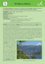
Itinerari consigliati a piedi nei dintorni di Menaggio con piantina
Itinerari consigliati a piedi nei dintorni di Menaggio con piantina
Itinerari consigliati a piedi nei dintorni di Menaggio con piantina
- No tags were found...

You also want an ePaper? Increase the reach of your titles
YUMPU automatically turns print PDFs into web optimized ePapers that Google loves.
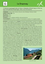
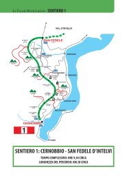
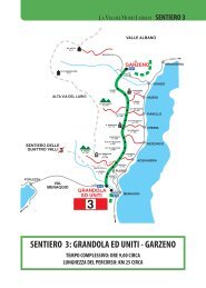
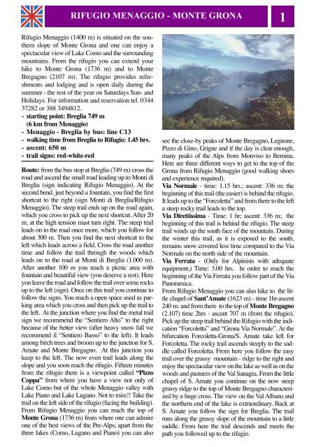
RIFUGIO MENAGGIO - MONTE GRONA1Rifugio <strong>Menaggio</strong> (1400 m) is situated on the southernslope of Monte Grona and one can enjoy aspectacular view of Lake Como and the surroun<strong>di</strong>ngmountains. From the rifugio you can extend yourhike to Monte Grona (1736 m) and to MonteBregagno (2107 m). The rifugio provides refreshmentsand lodging and is open daily during thesummer - the rest of the year on Saturdays Sun- andHolidays. For information and reservation tel. 034437282 or 388 3494812.- starting point: Breglia 749 m(6 km from <strong>Menaggio</strong>)- <strong>Menaggio</strong> - Breglia by bus: line C13- walking time from Breglia to Rifugio: 1.45 hrs.- ascent: 650 m- trail signs: red-white-redRoute: from the bus stop at Breglia (749 m) cross theroad and ascend the small road lea<strong>di</strong>ng up to Monti <strong>di</strong>Breglia (sign in<strong>di</strong>cating Rifugio <strong>Menaggio</strong>). At these<strong>con</strong>d bend, just beyond a fountain, you find the firstshortcut to the right (sign Monti <strong>di</strong> Breglia/Rifugio<strong>Menaggio</strong>). The steep trail ends up on the road again,which you cross to pick up the next shortcut. After 20m, at the high tension mast turn right. The steep trailleads on to the road once more, which you follow forabout 300 m. Then you find the next shortcut to theleft which leads across a field. Cross the road anothertime and follow the trail through the woods whichleads on to the road at Monti <strong>di</strong> Breglia (1.000 m).After another 100 m you reach a picnic area withfountain and beautiful view (you deserve a rest). Hereyou leave the road and follow the trail over some rocksup to the left (sign). Once on this trail you <strong>con</strong>tinue tofollow the signs. You reach a open space used as parkingarea which you cross and then pick up the trail tothe left. At the junction where you find the metal trailsign we recommend the “Sentiero Alto” to the rightbecause of the better view (after heavy snow fall werecommend il “Sentiero Basso” to the left). It leadsamong birch trees and broom up to the junction for S.Amate and Monte Bregagno. At this junction youkeep to the left. The now even trail leads along theslope and you soon reach the rifugio. Fifteen minutesfrom the rifugio there is a viewpoint called “PizzoCoppa” from where you have a view not only ofLake Como but of the whole <strong>Menaggio</strong> valley withLake Piano and Lake Lugano. Not to miss!! Take thetrail on the left side of the rifugio (facing the buil<strong>di</strong>ng).From Rifugio <strong>Menaggio</strong> you can reach the top ofMonte Grona (1736 m) from where one can admireone of the best views of the Pre-Alps; apart from thethree lakes (Como, Lugano and Piano) you can alsosee the close-by peaks of Monte Bregagno, Legnone,Pizzo <strong>di</strong> Gino, Grigne and if the day is clear enough,many peaks of the Alps from Monviso to Bernina.Here are three <strong>di</strong>fferent ways to get to the top of theGrona from Rifugio <strong>Menaggio</strong> (good walking shoesand experience required).Via Normale - time: 1.15 hrs.; ascent: 336 m; thebeginning of this trail (the easier) is behind the rifugio.It leads up to the “Forcoletta” and from there to the lefta steep rocky trail leads to the top.Via Direttissima - Time: 1 hr; ascent: 336 m; thebeginning of this trail is behind the rifugio. The steeptrail winds up the south face of the mountain. Duringthe winter this trail, as it is exposed to the south,remains snow covered less time compared to the ViaNormale on the north side of the mountain.Via Ferrata - (Only for Alpinists with adequateequipment,) Time: 3.00 hrs. In order to reach thebeginning of the Via Ferrata you follow part of the ViaPanoramica.From Rifugio <strong>Menaggio</strong> you can also hike to the littlechapel of Sant’Amate (1623 m) - time 1hr-ascent240 m. and from there to the top of Monte Bregagno(2.107) time 2hrs - ascent 707 m (from the rifugio).Pick up the steep trail behind the Rifugio with the in<strong>di</strong>cation“Forcoletta” and “Grona Via Normale”. At thebifurcation Forcoletta-Grona/S. Amate take left forForcoletta. The rocky trail ascends steeply to the saddlecalled Forcoletta. From here you follow the easytrail over the grassy mountain - ridge to the right andenjoy the spectacular view on the lake as well as on thewoods and pastures of the Val Sanagra. From the littlechapel of S. Amate you <strong>con</strong>tinue on the now steepgrassy ridge to the top of Monte Bregagno characterizedby a huge cross. The view on the Val Albano andthe northern end of the lake is extraor<strong>di</strong>nary. Back atS. Amate you follow the sign for Breglia. The trailruns along the grassy slope of the mountain to a littlesaddle. From here the trail descends and meets thepath you followed up to the rifugio.