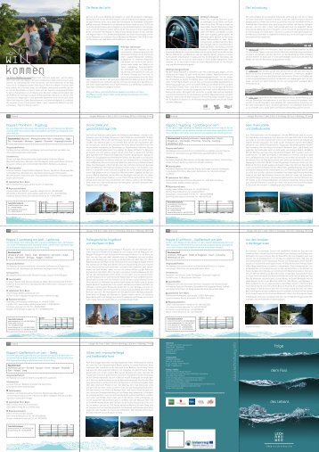
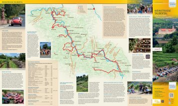
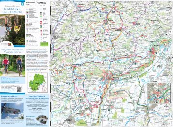
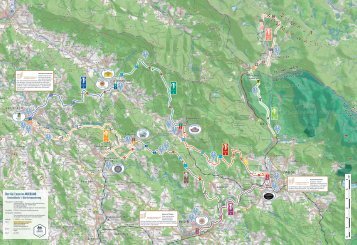
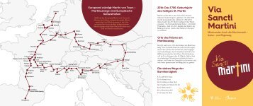
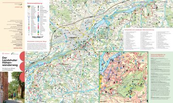
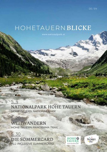
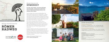
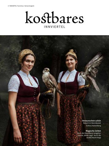
Route 3 SAURIS UND
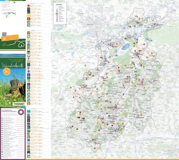
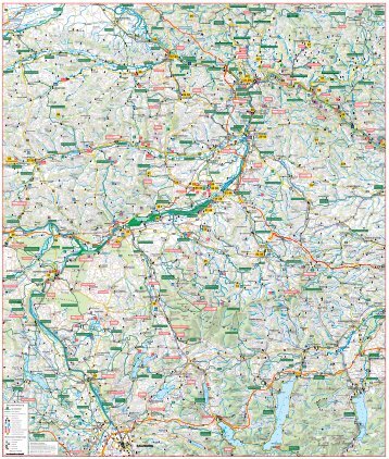
Route 3 SAURIS UND NATURPARK WEISSENSEE SAURIS AND WEISSENSEE NATURE PARK Sauris Weissensee Lake Weissensee Plöckenpass Plöcken Pass Spaghettikurven für Fortgeschrittene Von Hermagor aus geht es auf das Nassfeld (1.552 m), vorbei an Kärntens größtem Skigebiet nach Pontebba in Italien. Weiter durch das sehenswerte Val d’Aupa Richtung Moggio und Tolmezzo. Man folgt der Straße Richtung Ampezzo, wo man rechts nach Sauris abbiegt. Nun geht es auf der sehr schmalen und kurvenreichen Straße mit teilweise unbeleuchteten Tunnels hinauf nach Sauris auf 1.400 m (höchstgelegene Gemeinde in Friaul). Sauris ist eine deutsche Sprachinsel – hier spricht man im Alltag großteils Zahrisch. Als Delikatesse ist der Schinken aus Sauris bekannt. Ein Rohschinken mit Gebirgskräutern gewürzt und leicht geräuchert. Weiter geht es zum Pass Sella di Razzo und am Ende der Passstraße rechts Richtung Prato und Comeglians nach Paluzza. Die Route führt dann weiter Richtung Timau über den gut ausgebauten Plöckenpass auf 1.360 m bis nach Kötschach-Mauthen. Dort geht es in nördliche Richtung weiter über den Gailbergpass nach Oberdrauburg. Hier biegt man rechts ab und die restliche Strecke führt durch das Obere Drautal entlang der Drau nach Greifenburg. Über den Kreuzbergpass (1.077 m) geht es dann wieder zurück ins Gailtal nach Hermagor. Hairpins for the advanced From Hermagor, the route heads to Nassfeld (1,552 m), Carinthia’s biggest ski resort, to Pontebba in Italy. Then you continue on through the Val d’Aupa towards Moggio and Tolmezzo. You follow the road towards Ampezzo, where you then turn right to Sauris. You now ascend on a very narrow and curvy road, with some unlit tunnels, up to Sauris at 1,400 m (the highest municipality in Friuli). Sauris is a German-speaking enclave – where “Zahrisch” is widely spoken in everyday life. The prosciutto from Sauris is known as a delicacy: a raw ham seasoned with mountain herbs and lightly smoked. You continue to the pass “Sella di Razzo” and at the end of the pass road, head right towards Prato and Comeglians to Paluzza. The route then continues towards Timau along the well-developed Plöcken Pass at 1,360 m to Kötschach-Mauthen. There it continues north over the Gailberg Pass to Oberdrauburg, where you turn right. The remainder of the route leads through the Upper Drau Valley along the River Drau to Greifenburg and over the Kreuzberg Pass (1,077 m) back to Hermagor into the Gail Valley. Hermagor Nassfeldpass Sella di Cereschiatis Sella di Razzo Sella Valcalda Plöckenpass Gailbergsattel Kreuzberg GPS-Daten / GPS data: www.motorradland.kaernten.at Streckenlänge / Route length: 261 km Essen und Trinken / Eating and drinking: Alla Pace, 33020 Sauris di Sotto, Via Sauris di Sotto 38, Tel.: +39 0433 86010; Bärenwirt, 9620 Hermagor, Hauptstraße 17, Tel.: +43 4282 2052 Werkstatt / Repairs: Obereder Motos, 9754 Steinfeld, Josef-Fräß-Ehrfeld-Straße 18b, Tel.: +43 664 5140883 Sehenswert / Worth seeing: Garnitzenklamm, Sauris, Frontmuseum Kötschach-Mauthen, Naturpark Weißensee / Garnitzenklamm Gorge, Sauris, Kötschach-Mauthen Front Museum, Weissensee Nature Park.
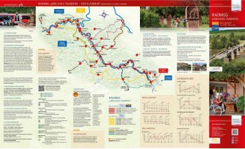
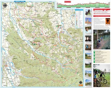
Route 4 TRIGLAV-NATIONALPARK TRIGLAV NATIONAL PARK Vršič-Straße Vršič Road Lago del Predil Mangartstraße Mangart Road Schräglage mit Geschichte Von Hermagor geht es entlang der B 111 nach Arnoldstein. Weiter nach Hart, dort abbiegen nach Kranjska Gora – Slowenien. Über den Wurzenpass (1.073 m) mit seiner engen, kurvenreichen Straße und bis zu 18 % Steigung bietet sich hier Fahrspaß der besonderen Art. Entlang der Save beginnt die anspruchsvolle Straße zum Vršič- Pass, mit 1.611 m der höchste Gebirgspass Sloweniens. Die 48 Haarnadelkurven bestehen im nördlichen Teil der Passstraße teilweise aus Kopfsteinpflaster. Am Vršič-Pass hat man einen herrlichen Panoramablick über den Triglav- Nationalpark. Weiter geht es hinunter ins Sočatal nach Bovec und dort über den Predil-Pass nach Italien. Wer möchte, kann vor der Grenze einen Abstecher über die ca. 12 km lange Mangartstraße zur Mangarthütte (1.906 m) am Fuße des 2.677 m hohen Mangarts machen. Im Tal führt die Strecke weiter in Richtung Sella Nevea und Chiusaforte nach Moggio Udinese. Dort biegt man ab ins nördlich verlaufende Val d’Aupa Richtung Pontebba. Nun geht es hinauf zum Nassfeldpass auf 1.552 m. Die Abfahrt auf österreichischer Seite bietet tolle Kurven und Kehren, die, gepaart mit einem guten Fahrbahnzustand, jedes Bikerherz höher schlagen lassen. A gradient with history From Hermagor, the route goes along the B111 to Arnoldstein, then on to Hart, turning there towards Kranjska Gora in Slovenia. You travel over the Wurzen Pass (1,073 m) with its narrow, curvy road and a gradient of up to 18%, offering a special kind of motorbiking fun. Along the River Save, the challenging road to the Vršič Pass starts, and at 1,611 m it is the highest mountain pass in Slovenia. The 48 hairpin bends partly consist of cobblestones in the northern part of the pass road. At the Vršič Pass you have a wonderful panoramic view over Triglav National Park. You continue down further into the Soča Valley to Bovec and there over the Predil Pass to Italy. Those who want to can take a detour before the border along the approx. 12-km-long Mangart Road to the Mangart lodge (1,906 m) at the foot of the 2,677-metre-high Mangart. In the valley, the route continues towards Sella Nevea and Chiusaforte to Moggio Udinese, where you turn into the northerly Val d’Aupa towards Pontebba. There the road ascends to the Nassfeld Pass at 1,552 m. The descent on the Austrian side offers great curves and bends, which, together with good road conditions, will delight every biker. Hermagor Wurzenpass Vršic`´ Sella di Cereschiatis Passo del Predil Sella Nevea Nassfeldpass GPS-Daten / GPS data: www.motorradland.kaernten.at Streckenlänge / Route length: 210 km Essen und Trinken / Eating and drinking: Wallnerwirt, 9601 Arnoldstein, Kärntner Straße 50, Tel.: +43 4255 2356; Da Livio Wulfenia, Nassfeld – Passo Pramollo 8, Tel.: +43 660 3186877 Werkstatt / Repairs: Motorradklinik Villach, 9500 Villach, Badstubenweg 68, Tel.: +43 4242 30788 Sehenswert / Worth seeing: Russische Kapelle an der Vršič-Straße, Triglav-Nationalparkzentrum in Trenta, Wildwasserfluss Soča / Russian chapel at the Vršič Road, Triglav National Park Centre in Trenta, Soča white water river