localização dos pontos de espera de práticos - Praticagem da Barra ...
localização dos pontos de espera de práticos - Praticagem da Barra ...
localização dos pontos de espera de práticos - Praticagem da Barra ...

You also want an ePaper? Increase the reach of your titles
YUMPU automatically turns print PDFs into web optimized ePapers that Google loves.
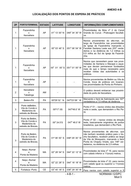
LOCALIZAÇÃO DOS PONTOS DE ESPERA DE PRÁTICOS<br />
ANEXO 4-B<br />
ZP PORTO/TERMINAL ESTADO LATITUDE LONGITUDE INFORMAÇÕES COMPLEMENTARES<br />
1<br />
1<br />
1<br />
1<br />
2<br />
Fazendinha<br />
x<br />
Itacoatiara<br />
Fazendinha<br />
x<br />
Itacoatiara<br />
Fazendinha<br />
x<br />
Itacoatiara<br />
Fazendinha<br />
X<br />
Itacoatiara<br />
Itacoatiara<br />
x<br />
Tabatinga<br />
AP 01 o 13’ 00” N 049 o 34’ 30” W<br />
AP 00 o 03’ 46” S 051 o 06’ 54” W<br />
AP 00 o 01’ 00” S 051 o 01’ 00” W<br />
AP<br />
-<br />
AM - -<br />
3 Belém-PA PA 00º29´32´´ N 047º23´08´´ W<br />
3<br />
3<br />
3<br />
4<br />
4<br />
Porto <strong>de</strong>Belém,<br />
Vila do Con<strong>de</strong> e<br />
Ma<strong>de</strong>ireira do<br />
estreito <strong>de</strong> Breves.<br />
Porto <strong>de</strong> Belém,<br />
Vila do Con<strong>de</strong> e<br />
Ma<strong>de</strong>ireira do<br />
estreito <strong>de</strong> Breves.<br />
Porto <strong>de</strong> Belém,<br />
Vila do Con<strong>de</strong> e<br />
Ma<strong>de</strong>ireira do<br />
estreito <strong>de</strong> Breves.<br />
Itaqui, Alumar<br />
e<br />
Ponta <strong>da</strong> Ma<strong>de</strong>ira<br />
Itaqui, Alumar<br />
e<br />
Ponta <strong>da</strong> Ma<strong>de</strong>ira<br />
PA 00º17’.0S 047º49.0’ W<br />
PA 00 o 24.5’S<br />
-<br />
047 o 46.0’ W<br />
PA 01º 06’ 00’’ S 048º 29’ 30’’ W<br />
MA 02 o 28’ 54” S 044 o 22’ 12” W<br />
MA 02 o 22’ 28” S 044 o 18’ 18” W<br />
Proximi<strong>da</strong><strong>de</strong>s <strong>da</strong> Bóia n o 2 do Canal<br />
Gran<strong>de</strong> do Curuá - <strong>Praticagem</strong> facultativa.<br />
Navios provenientes do alto-mar, ao<br />
largo <strong>de</strong> Fazendinha nas proximi<strong>da</strong><strong>de</strong>s<br />
<strong>da</strong> Igreja <strong>de</strong> Fazendinha marcando o<br />
Farolete Santana Leste aos 253 o ver<strong>da</strong><strong>de</strong>iros<br />
e na distância <strong>de</strong> 1,2 milhas ou<br />
0,5 milha ao Sul <strong>da</strong> Igreja <strong>da</strong> Fazendinha.<br />
Navios que necessitem parar nas proximi<strong>da</strong><strong>de</strong>s<br />
<strong>de</strong> Santana e Macapá e aqueles<br />
que <strong>de</strong>vam permanecer fun<strong>de</strong>a<strong>dos</strong><br />
mais do que o tempo necessário para<br />
receber visitas <strong>da</strong>s autori<strong>da</strong><strong>de</strong>s e os<br />
<strong>práticos</strong>.<br />
Navios provenientes <strong>de</strong> Belém ou Vila do<br />
Con<strong>de</strong>, troca <strong>de</strong> <strong>práticos</strong> em Icoaraci,<br />
nas proximi<strong>da</strong><strong>de</strong>s <strong>da</strong> Ponta do Pinheiro.<br />
O prático <strong>de</strong>verá embarcar nas proximi<strong>da</strong><strong>de</strong><br />
do porto <strong>de</strong> Itacoatiara.<br />
Marcando o farol <strong>de</strong> Salinópolis aos 167º<br />
ver<strong>da</strong><strong>de</strong>iros a 7,5 milhas <strong>de</strong> distância.<br />
Ponto nº 01 – navios vin<strong>dos</strong> <strong>da</strong>s direções<br />
norte e oeste, que <strong>de</strong>man<strong>de</strong>m o Rio Pará.<br />
Ponto nº 02 – navios vin<strong>dos</strong> <strong>da</strong> direção<br />
leste, basicamente originários <strong>de</strong> portos<br />
brasileiros, que <strong>de</strong>man<strong>de</strong>m o Rio Pará.<br />
Navios provenientes <strong>de</strong> alto-mar, que<br />
não tenham recebido prático para o trecho<br />
facultativo, recebem prático ao largo<br />
<strong>da</strong> Vila do Mosqueiro, marcando o farol<br />
Ponta do Chapéu Virado, aos 146º ver<strong>da</strong><strong>de</strong>iros,<br />
na distância <strong>de</strong> 2,5 milhas.<br />
Proximi<strong>da</strong><strong>de</strong>s <strong>da</strong> bóia n o 19, para navios<br />
com calado inferior a 11(onze) metros.<br />
Proximi<strong>da</strong><strong>de</strong>s <strong>da</strong> bóia n o 22, para navios<br />
com calado igual ou superior a 11(onze)<br />
metros.<br />
5 Fortaleza -Porto CE 03 o 40’ 18” S 038 o 29’ 30” W Para navios com calado superior a 9<br />
- 4-B-1 - NORMAM-12/DPC<br />
Mod 5
do Mucuripe metros.<br />
ANEXO 4-B<br />
ZP PORTO/TERMINAL ESTADO LATITUDE LONGITUDE INFORMAÇÕES COMPLEMENTARES<br />
5<br />
Fortaleza - Porto<br />
do Mucuripe<br />
CE 03 o 41’ 40” S 038 o 29’ 52” W<br />
5 Porto do Pecém CE 03 o 28’30”S 038 o 47’48”W<br />
6<br />
Areia Branca<br />
(Termisa)<br />
RN 04 o 43’ 36” S 036o 55’ 36” W<br />
7 Natal RN 05 o 44’ 48” S 035 o 10’ 30” W<br />
8 Cabe<strong>de</strong>lo PB 06 o 56’ 00” S 034 o 48’ W<br />
9 Recife e Suape PE 08 o 02’ 17” S 034 o 50’ 32” W Canal <strong>de</strong> Olin<strong>da</strong>.<br />
Para navios com calado inferior a 9 metros.<br />
9 Recife e Suape PE 08 o 04’ 09” S 034 o 50’ 56” W Canal do Sul <strong>de</strong> Recife.<br />
9 Recife e Suape PE 08 o 23’ 03” S 034 o 55’95” W Suape.<br />
10<br />
11<br />
11<br />
12<br />
Maceió<br />
e<br />
Terminal Químico<br />
AL 09 o 42’ 03” S 035 o 44’ 22” W<br />
Aracajú e <strong>Barra</strong><br />
<strong>dos</strong> Coqueiros SE 10 o 58’ 54” S 036 o 59’ 25” W<br />
Terminal Marítimo<br />
Inácio Barbosa<br />
(TMIB))<br />
Salvador, Portos e<br />
Terminais <strong>da</strong> Baía<br />
<strong>de</strong> To<strong>dos</strong> os<br />
Santos<br />
SE<br />
10 o 51’ 00” S<br />
036 o 54’ 00” W<br />
BA 12 o 59’ 00” S 038 o 33’ 00” W<br />
13 Ilhéus BA 14 o 45’ 53” S 039 o 01’ 28” W Porto do Malhado<br />
14 <strong>Barra</strong> do Riacho ES 19 o 50’ 30” S 040 o 02’ 00” W<br />
14<br />
14<br />
Vitória, Tubarão,<br />
Praia Mole, cais<br />
do Paul e Capuaba.<br />
Vitória, Tubarão,<br />
Praia Mole e seguintes<br />
terminais:<br />
Granéis líqui<strong>dos</strong>,<br />
Carvão e produtos<br />
si<strong>de</strong>rúrgicos.<br />
ES 20 o 19’ 34” S 040 o 15’ 16” W Porto <strong>de</strong> Vitória.<br />
Terminais, Hidrovias e Estaleiro no Estuário<br />
do Rio Sergipe.<br />
Terminal Marítimo Inácio Barbosa (TMIB)<br />
ES 20 o 20’ 00” S 040 o 14’ 12” W Terminais <strong>de</strong> Tubarão e Praia Mole<br />
14 UBU ES 20 o 46’ 24” S 040 o 32’ 33” W<br />
15 Forno RJ 22 o 58’ 24” S 041 o 59’ 06” W<br />
- 4-B-2 - NORMAM-12/DPC<br />
Mod 5
ANEXO 4-B<br />
ZP PORTO/TERMINAL ESTADO LATITUDE LONGITUDE INFORMAÇÕES COMPLEMENTARES<br />
15<br />
15<br />
15<br />
16<br />
16<br />
16<br />
17<br />
18<br />
21<br />
Rio <strong>de</strong> Janeiro,Niterói<br />
e seguintes<br />
terminais: Exxon,<br />
Esso, Shell,<br />
Manguinhos, Ilha<br />
d`Água e Redon<strong>da</strong>,<br />
Ponte do Thun<br />
e Texaco.<br />
Sepetiba, Ilha<br />
Guaíba, Ilha<br />
Gran<strong>de</strong> (TEBIG) e<br />
Angra <strong>dos</strong> Reis<br />
Sepetiba, Ilha<br />
Guaíba (MBR),<br />
Ilha<br />
Gran<strong>de</strong> (TEBIG) e<br />
Angra <strong>dos</strong> Reis<br />
São Sebastião<br />
e<br />
TEBAR<br />
São Sebastião e<br />
TEBAR<br />
Porto <strong>de</strong> Santos,<br />
Terminais : Co<strong>de</strong>sp,Cosipa,Cargill,<br />
Cutrale,<br />
Armazens Gerais,<br />
Dow Química,<br />
Libra, TECON,<br />
S.Francisco, Teaçu,<br />
Ultrafértil,<br />
ABTL e <strong>de</strong>mais<br />
terminais <strong>da</strong> baixa<strong>da</strong><br />
santista.<br />
Paranaguá ,<br />
Antonina e seguintesterminais:Petrobrás,<br />
Catalini e Ponta do<br />
Felix.<br />
São Francisco do<br />
Sul<br />
Itajaí, Navegantes,<br />
Shell,<br />
Dow Química ,<br />
Liquigás e terminal<br />
RJ<br />
23 o 00’ 00” S<br />
043 o 08’ 48” W<br />
RJ 23 o 08’ 36” S 044 o 04’ 36” W Entra<strong>da</strong> Leste.<br />
RJ 23 o 11’ 24” S 044 o 24’ 48” W Entra<strong>da</strong> Oeste.<br />
SP 23 o 42’ 00” S 045 o 21’ 00” W Entra<strong>da</strong> Norte.<br />
SP 23 o 53’ 30” S 045 o 29’ 30” W Entra<strong>da</strong> Sul.<br />
SP 24 o 00’ 33” S 046 o 20’ 12”W<br />
PR 25 o 37’ 22” S 048 o 15’ 36” W<br />
SC<br />
26°11’00”S<br />
048°28’06”W<br />
SC 26 o 55’ 00”S 048 o 34’ 30” W<br />
Entra<strong>da</strong> pelo canal dragado ou embarcações<br />
provenientes do litoral Sul.<br />
- 4-B-3 - NORMAM-12/DPC<br />
Mod 5
<strong>da</strong> Braskarne e<br />
<strong>de</strong>mais terminais<br />
do Rio Itajaí-Açu.<br />
ANEXO 4-B<br />
ZP PORTO/TERMINAL ESTADO LATITUDE LONGITUDE INFORMAÇÕES COMPLEMENTARES<br />
22 Imbituba SC 28 o 12’ 32” S 048 o 38’ 44” W<br />
19<br />
20<br />
Portos e terminais<br />
do interior <strong>da</strong> ZP.<br />
Lagoa <strong>dos</strong> Patos,<br />
Rios, Portos e<br />
Terminais<br />
Interiores<br />
RS 32 o 14’ 02” S 051 o 58’ 05” W<br />
RS 32 o 03’ 21” S 052 o 03’ 12” W<br />
- 4-B-4 - NORMAM-12/DPC<br />
Mod 5