a aplicação do landsat-tm no balizamento de parte da ... - Inpe
a aplicação do landsat-tm no balizamento de parte da ... - Inpe
a aplicação do landsat-tm no balizamento de parte da ... - Inpe

Create successful ePaper yourself
Turn your PDF publications into a flip-book with our unique Google optimized e-Paper software.
A APLICAÇÃO DO LANDSAT-TM NO BALIZAMENTO DE PARTE DA HIDROVIA<br />
DO RIO TAPAJÓS, ESTADO DO PARÁ<br />
ADERBAL C. CORRÊA 1<br />
GERALDO PEREIRA DA SILVA 2<br />
AGESANDRO C. CORRÊA 3<br />
1 UFPA- Universi<strong>da</strong><strong>de</strong> Fe<strong>de</strong>ral <strong>do</strong> Pará, CG/DGL/LAGEOS<br />
Av. Augusto Corrêa, 1, Guamá, 66075-900 Belém, PA, Brasil<br />
correa@marajo.secom.ufpa.br<br />
2 SUDAM- Superintendência <strong>do</strong> Desenvolvimento <strong>da</strong> Amazônia, DRN/CHSRA<br />
Av. Almirante Barroso, 426, Marco, 66090-000 Belém, PA, Brasil<br />
3 ETFPA- Escola Técnica Fe<strong>de</strong>ral <strong>do</strong> Pará, DE/Coord. Eletrônica<br />
Av. Almirante Barroso, 1155, Marco, 66093-020 Belém, PA, Brasil<br />
Abstract. The Amazon River and its major tributaries like the Tapajós River, are natural candi<strong>da</strong>tes for<br />
satellite monitoring of navigation conditions because of their importance to Brazil and <strong>no</strong>rthern South<br />
America. The study used Landsat TM <strong>da</strong>ta acquired in August and September, during the dry season,<br />
when the water level in the Tapajós River is fairly low. The results indicate that obstacles to navigation,<br />
such as shallow sand banks, can be accurately mapped taking into account the spatial resolution of the<br />
<strong>da</strong>ta. The excellent results of this study benefited in part of the unusually clear water of the Tapajós<br />
River.<br />
Keywords: Landsat TM, fluvial navigation, Amazon
1. Introdução<br />
O Rio Tapajós e seus afluentes tem um papel importante<br />
na re<strong>de</strong> <strong>de</strong> transporte fluvial regional, particularmente<br />
na região produtora <strong>de</strong> ouro com o mesmo <strong>no</strong>me, e<br />
como elo <strong>de</strong> ligação entre o Baixo Amazonas e a zona<br />
agrícola <strong>do</strong> Centro-Oeste brasileiro.<br />
O problema <strong>do</strong> <strong>balizamento</strong> <strong>de</strong> hidrovias requer a<br />
obtenção <strong>de</strong> <strong>da</strong><strong>do</strong>s sobre o curso <strong>de</strong> um rio tais como a<br />
posição <strong>de</strong> suas margens, ilhas, corre<strong>de</strong>iras, bancos <strong>de</strong><br />
areia e batimetria. Fotografias aéreas pancromáticas<br />
tem si<strong>do</strong> utiliza<strong>da</strong>s tradicionalmente como fonte <strong>de</strong><br />
<strong>da</strong><strong>do</strong>s. Entretanto, o custo <strong>de</strong> levantamentos periódicos<br />
é alto e a resolução espectral <strong>de</strong>ssas fotos é ina<strong>de</strong>qua<strong>da</strong><br />
para obter os <strong>da</strong><strong>do</strong>s <strong>de</strong>seja<strong>do</strong>s. Os <strong>da</strong><strong>do</strong>s obti<strong>do</strong>s por<br />
sistemas <strong>de</strong> ra<strong>da</strong>r <strong>de</strong> visa<strong>da</strong> lateral aerotransporta<strong>do</strong>s ou<br />
orbitais também tem utili<strong>da</strong><strong>de</strong> limita<strong>da</strong> uma vez que<br />
não propiciam informações sobre obstáculos à<br />
navegação que estejam submersos.<br />
2. Objetivos<br />
O estu<strong>do</strong> teve como objetivo principal o mapeamento<br />
planimétrico <strong>do</strong> Rio Tapajós, com a finali<strong>da</strong><strong>de</strong> <strong>de</strong><br />
<strong>balizamento</strong>, <strong>no</strong> trecho entre Itaituba e Jacareacanga.<br />
Os objetivos secundários foram <strong>do</strong>is. Um <strong>de</strong>les foi<br />
a avaliação <strong>de</strong> meto<strong>do</strong>logia utiliza<strong>da</strong> <strong>no</strong> Centro <strong>de</strong><br />
Hidroclimatologia e Sensoriamento Remoto (CHSRA).<br />
O outro foi o <strong>de</strong> analisar as limitações <strong>da</strong> tec<strong>no</strong>logia<br />
emprega<strong>da</strong>, visan<strong>do</strong> sua <strong>aplicação</strong> em ambientes fluviais<br />
potencialmente mais <strong>de</strong>sfavoráveis.<br />
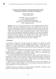
o<br />
0<br />
4<br />
8<br />
o<br />
o<br />
58 o<br />
W. GREENWICH<br />
AMAZONAS<br />
SURINAME<br />
Rio Tapajos<br />
Jacareacanga<br />
Rio Amazonas<br />
Itaituba<br />
54 o<br />
Santarem<br />
AMAPA<br />
Rio<br />
PARA<br />
Xingu<br />
MATO GROSSO<br />
50 o<br />
Rio Araguaia<br />
o o<br />
58 54 50 o<br />
OCEANO ATLANTICO<br />
Rio Tocantins<br />
BELEM<br />
TOCANTINS<br />
46 o<br />
MARANHAO<br />
0 100 200 300 Km<br />
46 o<br />
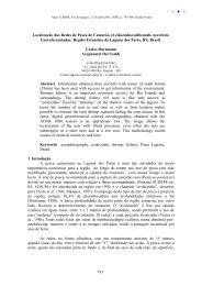
Fig. 1. Mapa <strong>de</strong> localização mostran<strong>do</strong> a área mapea<strong>da</strong>.<br />
3. A Área <strong>do</strong> Projeto<br />
0<br />
4<br />
8<br />
o<br />
o<br />
o<br />
A área <strong>de</strong> interesse <strong>do</strong> projeto é o curso <strong>do</strong> médio Rio<br />
Tapajós, com 343km <strong>de</strong> extensão, entre as ci<strong>da</strong><strong>de</strong>s <strong>de</strong><br />
Itaituba (4 o 16’S e 56 o 00’W) e Jacareacanga (6 o 14’S e<br />
57 o 46’W) <strong>no</strong> Esta<strong>do</strong> <strong>do</strong> Pará (Fig. 1). Esse trecho <strong>do</strong> rio<br />
está encaixa<strong>do</strong> em estruturas <strong>do</strong> embasamento cristali<strong>no</strong><br />
<strong>do</strong> Escu<strong>do</strong> Brasileiro e por isso apresenta condições <strong>de</strong><br />
difícil navegabili<strong>da</strong><strong>de</strong> (Ventura et al., 1975).<br />
4. Meto<strong>do</strong>logia<br />
A meto<strong>do</strong>logia aplica<strong>da</strong> ao estu<strong>do</strong> envolve a utilização<br />
<strong>da</strong> imagens multiespectrais <strong>do</strong> satélite Landsat-TM.<br />
Essa meto<strong>do</strong>logia é exemplifica<strong>da</strong> em trabalhos<br />
reuni<strong>do</strong>s por Williams e Carter (1976). Meneses et al.<br />
(1994) estu<strong>da</strong>ram as condições <strong>de</strong> navegabili<strong>da</strong><strong>de</strong> <strong>do</strong><br />
Rio Araguaia, utilizan<strong>do</strong> as ban<strong>da</strong>s TM-3, TM-4 e TM-<br />
5 para obter seus resulta<strong>do</strong>s. As ban<strong>da</strong>s TM-1 e TM-2<br />
não foram utiliza<strong>da</strong>s por sofrerem <strong>de</strong>gra<strong>da</strong>ção <strong>de</strong><br />
quali<strong>da</strong><strong>de</strong> <strong>de</strong>vi<strong>do</strong> ao espalhamento a<strong>tm</strong>osférico.<br />
O trabalho <strong>no</strong> Rio Tapajós utilizou imagens<br />
recentes <strong>do</strong> Landsat, obti<strong>da</strong>s <strong>no</strong> perío<strong>do</strong> <strong>de</strong> julho a<br />
<strong>de</strong>zembro, quan<strong>do</strong> o rio tem o nível <strong>de</strong> água mais baixo.<br />
O perio<strong>do</strong> <strong>de</strong> estiagem na região infelizmente também é<br />
a época <strong>da</strong>s queima<strong>da</strong>s, que contribuem com a fumaça<br />
para prejudicar a quali<strong>da</strong><strong>de</strong> <strong>da</strong>s imagens <strong>de</strong> satélites <strong>do</strong><br />
tipo Landsat.<br />
As ban<strong>da</strong>s TM-1, TM-2 e TM-3 (0,45-0,52, 0,52-<br />
0,60 e 0,63-0,69µm respectivamente) são as mais<br />
apropria<strong>da</strong>s para registrar as informações referentes aos<br />
obstáculos à navegação submersos. As ban<strong>da</strong>s TM-4,<br />
TM-5 e TM-7 (0,76-0,90, 1,55-1,75 e 2,08-2,35 µm<br />
respectivamente) na região <strong>do</strong> infravermelho próximo e<br />
médio, registram com precisão o contacto terra-água<br />
mas não fornecem <strong>da</strong><strong>do</strong>s sobre o ambiente aquático. A<br />
ban<strong>da</strong> TM-6 (10,40-12,50 µm), não utiliza<strong>da</strong> neste<br />
estu<strong>do</strong>, tem pouca resolução espacial (120m).<br />
A meto<strong>do</strong>logia aplica<strong>da</strong> incluiu a criação <strong>de</strong> uma<br />
base cartográfica com a utilização <strong>do</strong> AutoCad e o<br />
processamento digital <strong>da</strong>s imagens realiza<strong>do</strong> em um PC<br />
Sitim. Os resulta<strong>do</strong>s foram integra<strong>do</strong>s na fase final <strong>do</strong><br />
trabalho e reproduzi<strong>do</strong>s em mapas <strong>de</strong> 1:50.000.<br />
5. Da<strong>do</strong>s Utiliza<strong>do</strong>s e Procedimento <strong>de</strong> Trabalho<br />
As imagens utiliza<strong>da</strong>s foram coleta<strong>do</strong>s em 1991 e 1994,<br />
<strong>no</strong> perío<strong>do</strong> <strong>de</strong> julho a <strong>de</strong>zembro, com me<strong>no</strong>s <strong>de</strong> 10% <strong>de</strong><br />
cobertura <strong>de</strong> nuvens: WRS 229/64, 228/63, e 228/64.<br />
As imagens foram processa<strong>da</strong>s inicialmente para<br />
corrigir distorções radiométricas e geométricas. A<br />
correção geométrica foi realiza<strong>da</strong> utilizan<strong>do</strong> a<br />
convolução cúbica.<br />
As ban<strong>da</strong>s TM-1, TM-2 e TM-3 são essenciais<br />
para registrar com exatidão os obstáculos à navegação.<br />
Para sintetizar as informações <strong>no</strong> meio aquático foi<br />
aplica<strong>da</strong> a Análise por Principal Componente (APC)<br />
para essas ban<strong>da</strong>s. A PC1 foi utiliza<strong>da</strong> como uma <strong>da</strong>s<br />
tres ban<strong>da</strong>s em composições colori<strong>da</strong>s, juntamente com
as ban<strong>da</strong>s TM-2 e TM-5 processa<strong>da</strong>s individualmente,<br />
para realçar as informações <strong>de</strong> interesse. Para to<strong>da</strong> a<br />
área foram cria<strong>da</strong>s composições colori<strong>da</strong>s 5R PC1G 2B.<br />
Os procedimentos associa<strong>do</strong>s ao processamento<br />
digital <strong>de</strong> imagens incluiram o registro em filme <strong>da</strong><br />
imagens processa<strong>da</strong>s, a transferência <strong>da</strong> informação<br />
temática <strong>de</strong> interesse para a base cartográfica por meio<br />
<strong>de</strong> um equipamento ótico-mecânico (Procon).<br />
A base cartográfica utiliza<strong>da</strong> para registrar os<br />
resulta<strong>do</strong>s foi digitaliza<strong>da</strong> a partir <strong>de</strong> mapas na escala <strong>de</strong><br />
1:100.000 e 1:250.000 <strong>do</strong> IBGE e DSG <strong>de</strong> 1981, 1982 e<br />
1984. A área <strong>de</strong> interesse foi reproduzi<strong>da</strong> em 18 mapas<br />
limita<strong>do</strong>s por coor<strong>de</strong>na<strong>da</strong>s UTM. A projeção usa<strong>da</strong> foi a<br />
<strong>do</strong> elipsói<strong>de</strong> <strong>de</strong> Hayford, com o meridia<strong>no</strong> central a 57 o<br />
Oeste. O AutoCad foi usa<strong>do</strong> para fazer to<strong>da</strong> a<br />
apresentação cartográfica <strong>do</strong>s mapas impressos na<br />
escala <strong>de</strong> 1:50.000.<br />
6. Resulta<strong>do</strong>s e Conclusões<br />
Os resulta<strong>do</strong>s obti<strong>do</strong>s para as tres cenas <strong>do</strong> Landsat-TM<br />
atingiriram os objetivos propostos. Foram mapea<strong>da</strong>s as<br />
margens e ilhas, praias, e bancos <strong>de</strong> areia emersos e<br />
submersos. As águas <strong>do</strong> Rio Tapajós forneceram<br />
informações qualitativas sobre a batimetria. As imagens<br />
forneceram também indicações sobre as concentrações<br />
<strong>de</strong> sedimentos em suspensão.<br />
O traça<strong>do</strong> <strong>da</strong>s margens <strong>do</strong> Rio Tapajós a partir <strong>da</strong>s<br />
imagens <strong>do</strong> Landsat-TM não difere muito <strong>do</strong> mostra<strong>do</strong><br />
<strong>no</strong>s mapas topográficos <strong>de</strong> 1:100.000.<br />
A resolução espacial <strong>de</strong> 30m <strong>da</strong>s imagens implica<br />
na possibili<strong>da</strong><strong>de</strong> <strong>de</strong> não terem si<strong>do</strong> mapea<strong>do</strong>s obstáculos<br />
à navegação com dimensões me<strong>no</strong>res que essa. A<br />
meto<strong>do</strong>logia utiliza<strong>da</strong> obteve bons resulta<strong>do</strong>s mas há<br />
evi<strong>de</strong>ntemente a necessi<strong>da</strong><strong>de</strong> <strong>de</strong> se a<strong>do</strong>tar <strong>no</strong> futuro um<br />
processo totalmente digital.<br />
7. Agra<strong>de</strong>cimentos<br />
Os autores agra<strong>de</strong>cem ao Dr. Antonio Alberto Peque<strong>no</strong><br />
<strong>de</strong> Barros, Superinten<strong>de</strong>nte <strong>da</strong> AHIMOR e à<br />
SUDAM/DRN/CHSRA a autorização para publicar esse<br />
trabalho. Agra<strong>de</strong>cemos também a contribuição feita pela<br />
Enga. Isabel Bergh , Arq. Dirce Bibas, e técnicos Pedro<br />
Silva Neto, Luiz A. Fonseca e João Rodrigues.<br />
8. Referências Cita<strong>da</strong>s<br />
Meneses, P.R.; Ferreira Jr., L.G.; Souza, N.M.; Zerbini,<br />
N.; Riehl Jr., W.; Brod, J.A. e Lucatelli, G. Assessing<br />
Araguaia River navegability conditions through<br />
Landsat-TM image processing and Geographical<br />
Information Systems. Anais <strong>do</strong> ISPRS Commission VII<br />
Symposium, Rio <strong>de</strong> Janeiro 26-30 Set. 1994, Vol. 30,<br />
Parte 7b, 1994, pp.253-257.<br />
Ventura, L.M.; D’Ávila, L.M. e Barbosa, G.V. Geomorfologia<br />
in Folha SB.21 Tapajós -- Geologia, Geomor-<br />
fologia, Solos, Vegetação e Uso Potencial <strong>da</strong> Terra.<br />
DNPM, Projeto RADAM, 1975, Vol. 7, pp. 119-159.<br />
Williams, R.S. e Carter, W.D. ERTS-1 a new win<strong>do</strong>w<br />
on our planet. U.S. Geological Survey Prof. Paper 929,<br />
1976.