Gamaespectrometria da Ocorrência de Ouro do ... - Geologia Ufpr
Gamaespectrometria da Ocorrência de Ouro do ... - Geologia Ufpr
Gamaespectrometria da Ocorrência de Ouro do ... - Geologia Ufpr

Create successful ePaper yourself
Turn your PDF publications into a flip-book with our unique Google optimized e-Paper software.
7CISBGf/PS5<br />
<strong>Gamaespectrometria</strong> <strong>da</strong> Ocorrência <strong>de</strong> <strong>Ouro</strong> <strong>do</strong> Morro <strong>do</strong> Carneiro Branco-SC<br />
Luiz Fornazzari Neto (1,2) ; Francisco José Fonseca Ferreira (2) ; Maximilian Forlin (2) ; Sidnei Pires Rostirolla (3)<br />
(1)<br />
Curso <strong>de</strong> Pós-Graduação em <strong>Geologia</strong>-UFPR; (2) Laboratório <strong>de</strong> Pesquisas em Geofísica Aplica<strong>da</strong>, LPGA/UFPR;<br />
(3)<br />
Departamento <strong>de</strong> <strong>Geologia</strong>, UFPR<br />
Abstract<br />
One of the mo<strong>de</strong>rn applications of<br />
gammaspectrometry is the i<strong>de</strong>ntification of<br />
hydrothermally altered areas and the investigation of<br />
their relationships with mineralizing processes in a<br />
number of geological settings. The research <strong>de</strong>limits<br />
the terrain's gammaspectrometric signature in areas<br />
over which gold occurs. The gold occurences are<br />
characterized by sulphi<strong>de</strong>-rich quartz veins of average<br />
thickness of 2 m, with average gra<strong>de</strong>s of 6 g/ton<br />
(locally up to 17 g/ton over a shear zone associated<br />
with the intrusion of a small granitoid body. The<br />
terrains's gammaspectrometric signature <strong>de</strong>notes high<br />
U and Th gra<strong>de</strong>s, low Th/k ratios and anomalous F =<br />
K.U/Th values. Such geophyisical behavior reflects a<br />
hydrothermal alteration zone characterized by intense<br />
sericitization of potassic feldspars.<br />
Introdução<br />
A gamaespectrometria é tradicionalmente utiliza<strong>da</strong><br />
como apoio ao mapeamento geológico regional e à<br />
prospecção mineral. Recentemente, a introdução <strong>de</strong><br />
levantamentos <strong>de</strong> alta resolução e a transformação <strong>da</strong>s<br />
contagens por segun<strong>do</strong> em concentrações <strong>de</strong> K (%),<br />
eU e eTh em ppm, tem permiti<strong>do</strong> extrair informações<br />
valiosas <strong>de</strong>stes <strong>da</strong><strong>do</strong>s. Uma <strong>da</strong>s aplicações <strong>da</strong><br />
gamaespectrometria, aérea e terrestre, é a<br />
possibili<strong>da</strong><strong>de</strong> <strong>de</strong> i<strong>de</strong>ntificar áreas altera<strong>da</strong>s<br />
hidrotermalmente e, em conseqüência, explorar suas<br />
relações com processos <strong>de</strong> mineralização <strong>de</strong> ouro e<br />
prata, além <strong>de</strong> metais base (Cu-Pb-Zn), em vários<br />
ambientes geológicos. Neste senti<strong>do</strong>, o presente<br />
trabalho visa <strong>de</strong>finir a assinatura<br />
gamaespectrométrica terrestre <strong>da</strong> ocorrência <strong>de</strong> ouro e<br />
prata <strong>do</strong> Morro <strong>do</strong> Carneiro Branco (MCB), com o<br />
objetivo <strong>de</strong> estabelecer relações com os <strong>da</strong><strong>do</strong>s aéreos,<br />
permitin<strong>do</strong> <strong>de</strong>sta forma sugerir novos alvos<br />
exploratórios no âmbito <strong>da</strong> Folha Botuverá-SC<br />
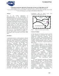
(Fornazzari et al., neste congresso). A ocorrência<br />
pesquisa<strong>da</strong> situa-se na porção central <strong>da</strong> menciona<strong>da</strong><br />
quadrícula (1:50.000), a qual é limita<strong>da</strong> pelas<br />
coor<strong>de</strong>na<strong>da</strong>s 27 o 00’ e 27 o 15’ <strong>de</strong> latitu<strong>de</strong> sul e 49 o 15’ e<br />
49 o 00’ <strong>de</strong> longitu<strong>de</strong> oeste (Figura 1).<br />
O trabalho envolveu um levantamento terrestre,<br />
assim como o processamento <strong>do</strong>s <strong>da</strong><strong>do</strong>s e a<br />
integração com informações geológicas e<br />
geoquímicas <strong>da</strong> região <strong>do</strong> MCB, além <strong>da</strong> <strong>de</strong>scrição <strong>de</strong><br />
seções <strong>de</strong>lga<strong>da</strong>s.<br />
25°<br />
26°<br />
27°<br />
28°<br />
29°<br />
54°<br />
53°<br />
52° 51° 50° 49° 48°<br />
PARANÁ<br />
SANTA CATARINA<br />
RIO GRANDE DO SUL<br />
CURITIBA<br />
FLORIANÓPOLIS<br />
54° 53° 52° 51° 50° 49° 48°<br />
Figura 1 – Mapa <strong>de</strong> localização <strong>da</strong> área <strong>do</strong> MCB<br />
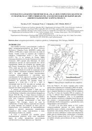
<strong>Geologia</strong> <strong>da</strong> Região <strong>do</strong> Morro <strong>do</strong> Carneiro Branco<br />
A região <strong>do</strong> Morro <strong>do</strong> Carneiro Branco situa-se no<br />
contexto <strong>da</strong> Folha Botuverá, cuja geologia é<br />
resumi<strong>da</strong>mente <strong>de</strong>scrita em Fornazzari et al. (neste<br />
congresso).<br />
O mapa geológico <strong>da</strong> região <strong>do</strong> MCB (Figura 2)<br />
foi organiza<strong>do</strong> a partir <strong>de</strong> informações coleta<strong>da</strong>s na<br />
déca<strong>da</strong> <strong>de</strong> 80 e cedi<strong>da</strong>s pela empresa <strong>de</strong> mineração<br />
Novo Prisma Lt<strong>da</strong> (Ribas, 1991). Localiza<strong>da</strong> na bor<strong>da</strong><br />
setentrional <strong>do</strong> granitói<strong>de</strong> Lajea<strong>do</strong> Baixo <strong>do</strong> fácies<br />
Valsungana (Cal<strong>da</strong>sso et al., 1995), a região envolve<br />
metapelitos (xistos) e metarcósios líticos pertencentes<br />
ao Complexo Brusque (Proterozóico Inferior-Médio),<br />
corpos granitói<strong>de</strong>s <strong>do</strong> Proterozóíco Superior e<br />
hornfels.<br />
O <strong>do</strong>mínio <strong>da</strong>s rochas metapelíticas agrupa<br />
sericita-xistos, sericita-quartzo xistos, micaxistos e<br />
mica-quartzo xistos (com biotita e/ou muscovita),<br />
xistos grafitosos, entre outros. Apresentam-se<br />
finamente folia<strong>do</strong>s, granulação fina, as vezes<br />
ban<strong>da</strong><strong>do</strong>s com intercalações milimétricas <strong>de</strong> quartzo.<br />
O metamorfismo regional atingiu a fácies xisto ver<strong>de</strong>.<br />
Os metapelitos são extremamente <strong>de</strong>forma<strong>do</strong>s,<br />
<strong>do</strong>bra<strong>do</strong>s e cataclasa<strong>do</strong>s, refletin<strong>do</strong> a forte tectônica<br />
plástica e rígi<strong>da</strong> impressa à região. Nas zonas <strong>de</strong> falha<br />
que cortam a área, com direções gerais E-W e N45E,<br />
os metapelitos exibem concentrações <strong>de</strong> óxi<strong>do</strong>s <strong>de</strong><br />
ferro dissemina<strong>da</strong>s na rocha e em fraturas, além <strong>de</strong><br />
vênulas <strong>de</strong> quartzo hidrotermal cobertas por uma<br />
película <strong>de</strong> manganês. Em alguns pontos ocorrem<br />
níveis <strong>de</strong> clorita-quartzo xistos finamente folia<strong>do</strong>s,<br />
com até 20% <strong>de</strong> pirita estratiforme e dissemina<strong>da</strong>,<br />
25°<br />
26°<br />
27°<br />
28°<br />
29°<br />
625
Assinatura Gamaespectrométrica<br />
acompanha<strong>da</strong> por injeções <strong>de</strong> quartzo hidrotermal, as<br />
vezes com sulfeto dissemina<strong>do</strong>.<br />
Os metarcósios líticos constituem<br />
metassedimentos <strong>de</strong> origem <strong>de</strong>tritica <strong>de</strong> granulação<br />
grossa, com matriz rica em quartzo e fenocristais<br />
nodulares subarre<strong>do</strong>n<strong>da</strong><strong>do</strong>s <strong>de</strong> até 3cm <strong>de</strong> diâmetro,<br />
além <strong>de</strong> porções ricas em clorita e outras em biotita.<br />
Ocorrem vênulas <strong>de</strong> quartzo, possivelmente <strong>de</strong><br />
origem hidrotermal, com 15 cm <strong>de</strong> espessura,<br />
exibin<strong>do</strong> pirita dissemina<strong>da</strong> em algumas porções. Os<br />
contatos com as <strong>de</strong>mais litologias são difusos e pouco<br />
níti<strong>do</strong>s, dificultan<strong>do</strong> sua cartografia.<br />
Os metapelitos e metarcóseos encontram-se<br />
intensamente afeta<strong>do</strong>s por metamorfismo termal<br />
relaciona<strong>do</strong> às intrusões graníticas presentes na área,<br />
caracterizan<strong>do</strong> importantes zonas <strong>de</strong> hornfels. Estas,<br />
no geral, apresentam-se intensamente sericitiza<strong>da</strong>s e<br />
muscovitiza<strong>da</strong>s, <strong>de</strong> granulação fina a média com a<br />
xistosi<strong>da</strong><strong>de</strong> preserva<strong>da</strong> e, em alguns locais,<br />
graiseniza<strong>da</strong>s. Localmente atingiram o fácies<br />
anfibolito.<br />
Quanto aos granitói<strong>de</strong>s, além <strong>do</strong> fácies<br />
Valsungana, o qual pre<strong>do</strong>mina na área, também<br />
ocorrem pequenos stocks atribuí<strong>do</strong>s ao fácies<br />
Guabiruba (Ribas, 1991)<br />
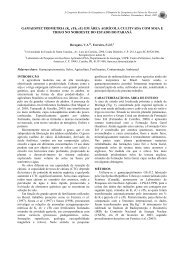
Ocorrências <strong>de</strong> <strong>Ouro</strong> <strong>da</strong> Região <strong>do</strong> MCB<br />
A região <strong>do</strong> MCB encerra diversas ocorrências <strong>de</strong><br />
ouro, as quais configuram pelo menos 8 alvos<br />
exploratórios (Figura 3), parcialmente avalia<strong>do</strong>s por<br />
algumas empresas <strong>de</strong> mineração e distribuí<strong>do</strong>s em<br />
uma área aproxima<strong>da</strong> <strong>de</strong> 800 ha.<br />
O alvo principal (MCB), motivo <strong>do</strong> presente<br />
estu<strong>do</strong>, é <strong>de</strong>fini<strong>do</strong> por um conjunto <strong>de</strong> veios <strong>de</strong><br />
quartzo sulfeta<strong>do</strong>s, dispostos segun<strong>do</strong> uma zona <strong>de</strong><br />
cisalhamento com direção geral N75 o -85 o W, a qual<br />
intercepta um pequeno corpo granitói<strong>de</strong> classifica<strong>do</strong><br />
como micro-monzonito, através <strong>de</strong> estu<strong>do</strong> petrológico<br />
preliminar (Vasconcelos, 1999), compatível com o<br />
fácies Valsungana <strong>de</strong> Cal<strong>da</strong>sso et al. (1995). Esta<br />
rocha apresenta feições <strong>de</strong> alteração hidrotermal,<br />
caracteriza<strong>da</strong> por uma intensa sericitização <strong>do</strong>s<br />
feldspatos potássicos (microclínio e oligoclásio).<br />
Na zona <strong>de</strong> cisalhamento os veios estão<br />
encaixa<strong>do</strong>s em um pacote <strong>de</strong>lga<strong>do</strong>, <strong>de</strong>forma<strong>do</strong> e<br />
concor<strong>da</strong>nte, <strong>de</strong> clorita-biotita-muscovita-quartzo<br />
xistos e muscovita-quartzo xistos, classifica<strong>do</strong>s como<br />
milonitos, on<strong>de</strong> observa-se os pares SS e SC <strong>de</strong><br />
transposição, indican<strong>do</strong> movimento lateral direito.<br />
A espessura média <strong>do</strong>s veios mineraliza<strong>do</strong>s é <strong>de</strong><br />
2m, po<strong>de</strong>n<strong>do</strong> atingir até 4,5m, com mergulho <strong>de</strong> 45 o<br />
para sul. Afloran<strong>do</strong> por cerca <strong>de</strong> 200m, exibem teores<br />
médios <strong>de</strong> 6g/t <strong>de</strong> ouro, po<strong>de</strong>n<strong>do</strong> atingir pontualmente<br />
até 17g/t, e 15g/t <strong>de</strong> prata (Gold Stan<strong>da</strong>rd Minas S.A.,<br />
comunicação pessoal), além <strong>de</strong> cobre e arsênio em<br />
menores proporções.<br />
Especula-se uma relação genética <strong>do</strong>s veios com<br />
os granitói<strong>de</strong>s Valsungana/Guabiruba, caracterizan<strong>do</strong><br />
um sistema mesotermal posiciona<strong>do</strong> em zona <strong>de</strong><br />
cúpula (Cal<strong>da</strong>sso et al., 1995), além <strong>de</strong> acentua<strong>do</strong><br />
controle estrutural, apesar <strong>da</strong> carência <strong>de</strong> estu<strong>do</strong>s.<br />
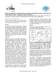
<strong>Gamaespectrometria</strong><br />
O levantamento geofísico terrestre foi realiza<strong>do</strong><br />
através <strong>de</strong> um gamaespectrômetro <strong>de</strong> 512 canais (GS-<br />
512, fabrica<strong>do</strong> pela Scintrex/Geofyzika), proce<strong>de</strong>n<strong>do</strong>se<br />
leituras em 160 pontos, espaça<strong>da</strong>s <strong>de</strong> 50m e 25m,<br />
ao longo <strong>do</strong>s acessos existentes (Figura 4), incluin<strong>do</strong><br />
8 <strong>de</strong>terminações nas encaixantes imediatas <strong>do</strong>s veios<br />
quartzo-auríferos, on<strong>de</strong> se dispunha <strong>de</strong> <strong>da</strong><strong>do</strong>s<br />
geoquímicos <strong>de</strong> amostras <strong>de</strong> canal (Figura 5).<br />
As leituras gamaespectrométricas foram<br />
toma<strong>da</strong>s em contagens por segun<strong>do</strong> e<br />
automaticamente transforma<strong>da</strong>s em concentrações <strong>de</strong><br />
K (%) e <strong>de</strong> eU e eTh em ppm, com base em<br />
procedimento <strong>de</strong> calibração realiza<strong>do</strong> no Instituto <strong>de</strong><br />
Radioproteção e Dosimetria – IRD, <strong>da</strong> Comissão<br />
Nacional <strong>de</strong> Energia Nuclear – CNEN. Os resulta<strong>do</strong>s<br />
finais são apresenta<strong>do</strong>s após a remoção <strong>do</strong><br />
background atmosférico para ca<strong>da</strong> canal, ou seja:<br />
K(%) = 0; U = 0.1 ppm e Th = 1.8 ppm, realiza<strong>da</strong><br />
sobre lâmina d’água superior a 2m.<br />
Além <strong>do</strong>s <strong>da</strong><strong>do</strong>s <strong>de</strong>stes três canais, foram<br />
calcula<strong>da</strong>s as razões U/Th, Th/K e U/K, além <strong>do</strong><br />
parâmetro F = K*U/Th (Gnojek & Prichystal, 1985).<br />
Os valores <strong>da</strong> média (x), <strong>do</strong> <strong>de</strong>svio padrão (s),<br />
mínimo, máximo e coeficiente <strong>de</strong> variação (CV),<br />
po<strong>de</strong>m ser visualiza<strong>do</strong>s na Tabela 1. Nota-se que os<br />
coeficientes <strong>de</strong> variação são menores que 1,<br />
admitin<strong>do</strong>-se uma distribuição normal para o<br />
conjunto <strong>de</strong> <strong>da</strong><strong>do</strong>s.<br />
x s x+1s Min Max CV<br />
K 3,08 1,04 4,12 1,1 6,2 0,34<br />
U 3,20 1,49 4,69 0,5 9,7 0,47<br />
TH 17,85 7,50 25,35 4,2 42,3 0,42<br />
F 0,59 0,32 0,91 0,11 1,737 0,54<br />
U/TH 0,19 0,08 0,27 0,05 0,47 0,41<br />
TH/K 6,25 2,97 9,22 2,19 17,64 0,47<br />
U/K 1,12 0,60 1,72 0,24 3,54 0,53<br />
Tabela 1 – Estatística básica <strong>da</strong>s variáveis<br />
gamaespectrométricas.<br />
A análise <strong>de</strong>stas relações gamaespectrométricas<br />
foi nortea<strong>da</strong> por alguns resulta<strong>do</strong>s <strong>da</strong> literatura<br />
internacional, obti<strong>do</strong>s através <strong>de</strong> testes em áreas<br />
mineraliza<strong>da</strong>s e seu relacionamento com o quimismo<br />
626
Assinatura Gamaespectrométrica<br />
<strong>da</strong>s rochas envolvi<strong>da</strong>s. Constatou-se que em zonas <strong>de</strong><br />
alteração hidrotermal associa<strong>da</strong>s à mineralizações <strong>de</strong><br />
ouro em ambiente similar ao <strong>da</strong> área em questão,<br />
ocorre um enriquecimento <strong>de</strong> K e U em <strong>de</strong>trimento <strong>do</strong><br />
Th, o qual po<strong>de</strong>, em alguns casos, até ser <strong>de</strong>pleta<strong>do</strong><br />
(Dickson & Scott 1997). Estas relações também são<br />
evi<strong>de</strong>ncia<strong>da</strong>s pelo parâmetro F =K*U/Th.<br />
GAMAESPECTROMETRIA GEOQUÍMICA<br />
K<br />
%<br />
U<br />
ppm<br />
Th<br />
ppm<br />
Th/K U/K U/Th<br />
Ppm<br />
F K<br />
%<br />
Au<br />
ppb<br />
Ag<br />
ppm<br />
1 4,2 4,2 27,2 6,48 1 0,15 0,65 1,9 28 4,1<br />
2 5,7 6,6 25,3 4,44 1,16 0,26 1,49 3,7 8 1,5<br />
3 4 6,2 24,6 6,15 1,55 0,25 1,0 2,9 15 1,5<br />
4 5,1 5,1 30,7 6,02 1 0,17 0,85 2,7 5 1,5<br />
5 4,7 4,1 18,9 4,02 0,87 0,22 1,02 3,6 1003 1,5<br />
6 4,2 5 17,4 4,14 1,19 0,29 1,21 3,6 1003 1,5<br />
7 3,6 4,5 31,4 8,72 1,25 0,14 0,5 1,1 1722 15<br />
8 6,2 3,7 22,5 3,63 0,6 0,16 1,02 NÃO ANALISADO<br />
Tabela 2 – Resulta<strong>do</strong>s geofísicos e geoquímicos <strong>do</strong> veio e<br />
<strong>da</strong>s encaixantes <strong>do</strong> MCB.<br />
Resulta<strong>do</strong>s Obti<strong>do</strong>s<br />
Os resulta<strong>do</strong>s obti<strong>do</strong>s permitiram <strong>de</strong>terminar a<br />
assinatura gamaespectrométrica <strong>da</strong> ocorrência <strong>do</strong><br />
MCB, cuja representação gráfica po<strong>de</strong> ser observa<strong>da</strong><br />
nas figuras 6, 7 e 8, enquanto a Tabela 2 exibe os<br />
<strong>da</strong><strong>do</strong>s geofísicos e geoquímicos <strong>do</strong>s veios e <strong>de</strong> suas<br />
encaixantes imediatas (Figura 5). Esta assinatura é<br />
caracteriza<strong>da</strong> por teores <strong>de</strong> potássio e urânio acima <strong>da</strong><br />
média (Figura 6). Apesar <strong>da</strong> razão Th/K não<br />
evi<strong>de</strong>nciar claramente, para algumas amostras, um<br />
enriquecimento expressivo <strong>de</strong> K em relação ao Th<br />
(Figura 7), este comportamento sugere que o tório<br />
também po<strong>de</strong> ter migra<strong>do</strong>, juntamente com o potássio<br />
e o urânio (Figura 8), durante o processo <strong>de</strong> alteração<br />
hidrotermal, apesar <strong>do</strong> antagonismo entre tais<br />
elementos (Efimov, 1978 apud Gnojek & Prichystal,<br />
1985). Porém, <strong>de</strong> acor<strong>do</strong> com Dickson & Scoott<br />
(1997), este comportamento, apesar <strong>de</strong> atípico, foi<br />
verifica<strong>do</strong> em algumas mineralizações <strong>de</strong>ste tipo. O<br />
parâmetro F, como espera<strong>do</strong>, apresentou valores<br />
eleva<strong>do</strong>s nas encaixantes imediatas <strong>do</strong>s veios<br />
mineraliza<strong>do</strong>s.<br />
Os teores <strong>de</strong> K (%) obti<strong>do</strong>s por<br />
gamaespectrometria e por análises geoquímicas <strong>de</strong><br />
amostras <strong>de</strong> canais <strong>do</strong>s veios, pelo méto<strong>do</strong> <strong>de</strong><br />
digestão multiáci<strong>da</strong>/ICP (Figura 9), mostra que há<br />
uma certa correlação qualitativa entre estes méto<strong>do</strong>s.<br />
Os teores geoquímicos são inferiores aos<br />
gamaespectrométricos, possivelmente porque a<br />
amostragem <strong>do</strong>s canais representa os teores médios<br />
<strong>do</strong> segmento amostra<strong>do</strong>, enquanto que as leituras<br />
radiométricas são pontuais. Estes teores eleva<strong>do</strong>s <strong>de</strong><br />
potássio nos milonitos ao longo <strong>da</strong> zona <strong>de</strong><br />
cisalhamento, são condizentes com a intensa<br />
sericitização e muscovitização verifica<strong>da</strong>s em campo<br />
e em seções <strong>de</strong>lga<strong>da</strong>s. Cabe ressaltar que assinatura<br />
semelhante também foi verifica<strong>da</strong> por estu<strong>do</strong><br />
gamaespectrométrico aéreo no conjunto <strong>da</strong> Folha<br />
Botuverá (Fornazzari et al., neste congresso).<br />
Conclusões<br />
A assinatura gamaespectrométrica <strong>da</strong> ocorrência <strong>de</strong><br />
ouro <strong>do</strong> MCB foi caracteriza<strong>da</strong> por enriquecimentos<br />
<strong>de</strong> K, U e <strong>do</strong> parâmetro F e por relativamente baixas<br />
razões Th/K. Tal comportamento é interpreta<strong>do</strong> pela<br />
intensa sericitização <strong>do</strong>s milonitos na zona <strong>de</strong><br />
cisalhamento, junto aos veios e no granitói<strong>de</strong><br />
encaixante. O processo hidrotermal é caracteriza<strong>do</strong><br />
por uma zona <strong>de</strong> alteração fílica e pervasiva, em<br />
correspondência com este tipo <strong>de</strong> mineralização em<br />
várias partes <strong>do</strong> mun<strong>do</strong>. Os resulta<strong>do</strong>s <strong>de</strong>sta pesquisa<br />
apontam para a necessi<strong>da</strong><strong>de</strong> <strong>de</strong> incrementar este tipo<br />
<strong>de</strong> estu<strong>do</strong> no Brasil, em <strong>de</strong>pósitos minerais com bons<br />
controles geológico e geoquímico, no senti<strong>do</strong> <strong>de</strong> não<br />
apenas <strong>de</strong>terminar suas assinaturas<br />
gamaespectrométricas, mas, sobretu<strong>do</strong>, sugerir novos<br />
alvos exploratórios.<br />
Referências Bibliográficas<br />
Cal<strong>da</strong>sso et al. 1995. <strong>Geologia</strong> <strong>da</strong> Folha Botuverá<br />
(SG.22-Z-D-I-2), Esta<strong>do</strong> <strong>de</strong> Santa Catarina,<br />
Escala 1:50.000. Programa Levantamentos<br />
Geológicos Básicos <strong>do</strong> Brasil,<br />
MME/SMM/CPRM, 303p.<br />
Dickson, B.L. & Scoott, K.M. 1997. Interpretation of<br />
aerial gamma-ray surveys – adding the<br />
geochemical factors. In: Airborne Magnetic and<br />
Radiometric Surveys, AGSO Journal of<br />
Australian Geology & Geophysics, 17(2):187-<br />
200.<br />
Fornazzari Neto, L.; Ferreira, F.J.F.; Campos, A.F.<br />
2001. <strong>Gamaespectrometria</strong> Aplica<strong>da</strong> à Prospecção<br />
<strong>de</strong> <strong>Ouro</strong> na Folha Botuverá-SC (neste congresso).<br />
Gnojek, I. & Prichystal, A. 1985. A new zinc<br />
mineralization <strong>de</strong>tected by airbornegamma-ray<br />
spectrometry in northern Moravia<br />
(Czechoslovakia). Geoexploration, 23(4), 491-<br />
502.<br />
Ribas, A.U. 1991. Relatório Parcial <strong>de</strong> Pesquisa –<br />
Área <strong>do</strong> Morro <strong>do</strong> Carneiro Branco. DNPM,<br />
processo N o 815.097/88, GEOCON – <strong>Geologia</strong> e<br />
Consultoria Lt<strong>da</strong>.<br />
Vasconcellos, E.G. 1999. Análise Petrográfica <strong>de</strong><br />
Rochas (MCB), Gold Stan<strong>da</strong>rd Minas S. A.<br />
(inédito).<br />
627
Assinatura Gamaespectrométrica<br />
X (K)<br />
8<br />
7<br />
6<br />
U (ppm)<br />
5<br />
4<br />
3<br />
X (U)<br />
2<br />
1<br />
0<br />
0,5 1,0 1,5 2,0 2,5 3,0 3,5 4,0 4,5 5,0 5,5 6,0 6,5<br />
Figura 2 – Mapa geológico <strong>da</strong> região <strong>do</strong> MCB<br />
K (ppm)<br />
GERAL<br />
VEIO (Au)<br />
Figura 6 - Correlação gamaespectrométrica entre U e K<br />
16<br />
X (F)<br />
14<br />
12<br />
10<br />
Th/K<br />
8<br />
6<br />
4<br />
2<br />
X (Th/K)<br />
0<br />
0,0 0,2 0,4 0,6 0,8 1,0 1,2 1,4 1,6 1,8 2,0<br />
PARÂMETRO F = K*U/Th<br />
GERAL<br />
VEIO (Au)<br />
Figura 3 – Mapa <strong>de</strong> amostragem <strong>de</strong> ouro em rocha<br />
Figura 7 - Correlação gamaespectrométrica entre Th/K e F<br />
8<br />
X (Th)<br />
7<br />
6<br />
U (ppm)<br />
5<br />
4<br />
3<br />
X (U)<br />
2<br />
1<br />
Figura 4 – Mapa <strong>de</strong> pontos gamaespectrométricos<br />
0<br />
0 5 10 15 20 25 30 35 40 45 50<br />
Th (ppm)<br />
GERAL<br />
VEIO (Au)<br />
Figura 8 - Correlação gamaespectrométrica entre U e Th<br />
a)<br />
veios <strong>de</strong><br />
quartzo<br />
Planta<br />
Estra<strong>da</strong><br />
8<br />
xisto<br />
6<br />
7<br />
5<br />
granito<br />
0 4 8 12m<br />
N<br />
solo<br />
b)<br />
Perfil<br />
2 3 4<br />
1<br />
granito xisto<br />
veio <strong>de</strong> quartzo<br />
0 2 4m<br />
granito<br />
Ponto Gamaespectrométrico<br />
Canal <strong>de</strong> Amostragem <strong>de</strong> Rocha<br />
Figura 5 – Croquis <strong>de</strong> amostragem <strong>de</strong> canais e pontos <strong>de</strong><br />
leitura gamaespectrométrica<br />
S<br />
K (%)<br />
6<br />
5<br />
4<br />
3<br />
2<br />
1<br />
0<br />
1 2 3 4 5 6 7<br />
K_ gama<br />
Amostras<br />
K_geoq<br />
Figura 9 - Resulta<strong>do</strong>s <strong>de</strong> K obti<strong>do</strong>s por gama e geoquímica<br />
628