PolÃtica de Distribuição de Imagens do INPE e o - INPE/OBT/DGI
PolÃtica de Distribuição de Imagens do INPE e o - INPE/OBT/DGI
PolÃtica de Distribuição de Imagens do INPE e o - INPE/OBT/DGI
- No tags were found...

You also want an ePaper? Increase the reach of your titles
YUMPU automatically turns print PDFs into web optimized ePapers that Google loves.
Política <strong>de</strong> Distribuição<strong>de</strong> <strong>Imagens</strong> <strong>do</strong> <strong>INPE</strong>e oCDSR – CENTRO DE DADOS DESENSORIAMENTO REMOTOLuís Geral<strong>do</strong>lgeral<strong>do</strong>@dgi.inpe.br5o.SEMINÁRIO DE SENSORIMENTO REMOTO,INTERPRETAÇÃO E PROCESSAMENDE IMAGENS25 <strong>de</strong> novembro <strong>de</strong> 2008
HISTÓRICO DO SENSORIAMENTO REMOTO NO BRASIL• JUN/1972 - Satélite ERTS• ABR/1973 – Brasil passa a receberos da<strong>do</strong>s• Cobertura <strong>de</strong> 80% da América <strong>do</strong> Sul• Satélites:•LANDSAT-1973, SPOT1-1988,ERS1-1991, ERS2-1995,CBERS1-1999, RADARSAT1-2001, SPOT4-2003, CBERS2-2003 e CBERS2B-2007• 2004 – Projeto CDSR e as imagensCBERS sem custo pela Internet• 2006 – Abertura <strong>do</strong> Catálogo CDSRpara América <strong>do</strong> Sul• 2007 – Abertura <strong>do</strong> Catálogo para oMun<strong>do</strong>•2008 – Antena ENVISAT em C.P.
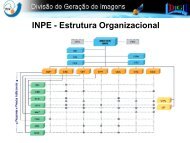
MINISTÉRIO DA CIÊNCIA E TECNOLOGIA<strong>INPE</strong>-INSTITUTO NACIONALDE PESQUISAS ESPACIAISCOORDENAÇÃO GERAL DEOBSERVAÇÃO DA TERRA-<strong>OBT</strong>– <strong>DGI</strong>-DIVISÃO DE GERAÇÃO DE IMAGENS• Estação <strong>de</strong> Recepção e Gravação – CuiabáMT• Estação <strong>de</strong> Processamento – C.Paulista SP– DPI-DIVISÃO DE PROCESSAMENTO DEIMAGENS(Spring e TerraLib)– DSR-DIVISÃO DE SENSORIAMENTO REMOTO
CDSR – CENTRO DE DADOS DE SR• O Centro <strong>de</strong> Da<strong>do</strong>s <strong>de</strong> Sensoriamento Remotoimplementa uma política agressiva, facilita<strong>do</strong>ra <strong>do</strong>uso <strong>de</strong> sensoriamento remoto no país.Status:– CBERS-2 – 2003 até 21 <strong>de</strong> novembro 2007 (<strong>de</strong>forma regular);– CBERS-2B – Distribuin<strong>do</strong> da<strong>do</strong>s WFI, CCD eHRC;– LANDSAT 1, 2, 3 – 1973 a 1983– LANDSAT 5 e 7 – 1984-2008• Usuários ativos: +16.000• <strong>Imagens</strong> já distribuidas: +679.000• 2004=+57mil;• 2005,2006 e 2007=+100mil• 2008= + 278.496 imagens (24-11-2008-18:10h)
VOLUME DE DADOS• Acervo:– Mais <strong>de</strong> 220TB (LANDSAT; CBERS; ERS; SPOT;RADARSAT; MODIS)• Da<strong>do</strong>s Brutos Grava<strong>do</strong>s por Dia:– 2 passagens por dia para cada satélite• LANDSAT-5 – 14.000 imagens por ano (TM)• CBERS 2B – 124.750 imagens por ano(CCD22.000 + 2.750 WFI + 100.000 HCR)• CBERS-2 – 46.750 imagens por ano (CCD22.000 + IRMS 22.000 + 2.750 WFI)
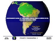
CDSR – CENTRO DE DADOS DE SR• DESCRIÇÃO DO PROJETO– Orçamento:• 2002-2004 - R$ 2.090.000,00– (FINEP R$ 1.300.000,00 e <strong>INPE</strong> - R$ 790.000,00)• 2005-2006 - R$ 700.000,00 <strong>INPE</strong>– Expansão <strong>do</strong> Centro <strong>de</strong> Da<strong>do</strong>s, <strong>de</strong> 45TB para 140TB epara 280TB.• 2007 - R$ 200.000,00 <strong>INPE</strong>– Para melhorar a eficiência <strong>do</strong> sistema <strong>de</strong>armazenameno.• 2008 – R$ 8.500.000,00– 500.000,00 EM EQUIPAMENTOS, 1.100.000,00 NOVA SUBESTAÇÃO DEENERGIA, 600.000,00 AR CONDICIONADO, 1.800.000,00MODERNIZAÇÃO DA ESTAÇÃO DE CUIABÁ E 4.500.000,00 ANTENAENVISAT EM CP.– Será investi<strong>do</strong> cerca <strong>de</strong> R$ 500.000,00 ano
COM A CRIAÇÃO DO CDSR• Transposição <strong>de</strong> mídia <strong>do</strong> acervo garantin<strong>do</strong> asegurança <strong>do</strong>s da<strong>do</strong>s;• Recuperação e distribuição <strong>do</strong>s da<strong>do</strong>s históricos (1973-1983), em formato GeoTIFF, pela internet;• Distribuição <strong>do</strong>s da<strong>do</strong>s CBERS e LANDSAT pela internetsem custos para o usuário;• Da<strong>do</strong>s disponíveis no mesmo dia da passagem <strong>do</strong>satélite (RNP);• Nacionalização <strong>do</strong> sistema <strong>de</strong> produção <strong>de</strong> imagens;• Sistema <strong>de</strong> Recepção e <strong>de</strong> Processamento Multisatélites;• A partir <strong>de</strong> 2004 assumiu a li<strong>de</strong>rança mundial emdistribuição <strong>de</strong> imagens.
EM ANDAMENTO• Ingestão das <strong>Imagens</strong> LANDSAT-TM eETM+, inclusive por solicitação <strong>do</strong> usuário;• Produto CBERS - Nível 3 - georeferencia<strong>do</strong>por Ponto <strong>de</strong> Controle;• Ingestão <strong>de</strong> <strong>Imagens</strong> HRC/CBERS-2B(2,7m), última atualização SET/2008;• Mais <strong>de</strong> 70 mil HRC disponíveis e mais <strong>de</strong> 35 milpedi<strong>do</strong>s atendi<strong>do</strong>s• Com o CBERS-2B, entendimentos paraimplantação <strong>de</strong> estações <strong>de</strong> recepção eprocessamento em outros países sãoretoma<strong>do</strong>s;
EM ANDAMENTO• AQUA/TERRA – da<strong>do</strong>s MODIS – Estarãodisponíveis até mea<strong>do</strong>s <strong>de</strong> 2009;• ENVISAT – Antena em C.Paulista SP,MERIS e ASAR, receben<strong>do</strong> eprocessan<strong>do</strong> até fevereiro <strong>de</strong> 2009;• Acor<strong>do</strong> com a Índia para recepção eprocessamento <strong>do</strong> satélite IRS(instrumentos com resolução <strong>de</strong> 23m e50m);
PRODUTOS <strong>DGI</strong>CaracterísticasReamostragemDatumGra<strong>de</strong>amentoFormatoProjeçãoCartográficaCorreçãoProduto PadrãoConvoluçãoCúbicaSAD 69Base/PontoGeotiffUTMRadiométricatrica/Geométrica
PRODUTOS LANDSAT• MSS (LANDSAT 1, 2 e 3)» 1973/1984– 82m - G,R,NIR,NIR - 185km• TM (LANDSAT 5)» Des<strong>de</strong> 1984– 30m e 120m - B,G,R,NIR,MIR,TIR,DIR - 185km• ETM+ (LANDSAT 7)» 1999/2003– 15m e 30m e 60m - PAN,B,G,R,NIR,MIR,TIR*,DIR -185km
Imagea<strong>do</strong>res <strong>do</strong>s CBERS-1 e CBERS-2CâmerasResoluçãoBandasFaixaimageadaCCD20 mB, G, R,NIR, PAN113 km,visada lateral(32 o )IRMSS80 m160mMIR, PAN,TIR120 kmWFI260 mR, NIR890 kmGravação a bor<strong>do</strong> <strong>do</strong>s da<strong>do</strong>s da CCD
Imagea<strong>do</strong>res <strong>do</strong> CBERS-2BCâmerasResoluçãoBandasFaixaimageadaCCD20 mB, G, R,NIR, PAN113 km,visada lateral(32 o )HRC2,7 mPAN27 km, visadalateral (4 o )WFI260 mR, NIR890 kmGravação a bor<strong>do</strong> <strong>do</strong>s da<strong>do</strong>s da CCD, HRC e WFI
High Resolution Panchromatic Camara – HRC (CBERS-2B)• Spectral Bands :0,50 - 0,80 µm (pan)• Spatial Resolution :2,7 x 2,7 m• Band Width : 27 km• Temporal Resolution :130 days (26x5);((in the mo<strong>de</strong> of operation a<strong>do</strong>pted)• Rate of data in the Image :432 Mbit/s (antes da compressão)
<strong>INPE</strong> - Planejamento <strong>de</strong> Lançamento2010 2015 2020CBERS-3CBERS-4CBERS-5CBERS-6AMAZONIA-3AMAZONIA-1AMAZONIA-2MAPSAR-1MAPSAR-2
Amazônia-1 (carga útil óptica)Bandas Espectrais(µm)AWFI0,45-0,52 B0,52-0,59 G0,63-0,69 R0,77-0,89 NIRResolução Espacial (m) 40Faixa imageada (km) 780Revisita (dias) 5– Garantir imageamento global a cada <strong>do</strong>is diasao operar em conjunto com o CBERS-3– Prover da<strong>do</strong>s ambientais para o planeta
Imagea<strong>do</strong>res <strong>do</strong>s CBERS-3 e CBERS-4CâmerasResoluçãoBandasFaixaimageadaPAN5 m10mPAN,G, R, NIR60 km, visadalateral (32 o )MUX20 mB, G, R,NIR120 kmIRS40 m80 mNIR, MIR,TIR120 kmWFI73 mB, G, R,NIR890 kmGravação a bor<strong>do</strong> <strong>do</strong>s da<strong>do</strong>s <strong>de</strong> todas as câmeras
CBERS 5 – 6 Sensor ConfigurationCCD 20 m (800 km)HRC 2.5 m (60 km)0.4 0.5 0.7 0.9 1.1 1.5 1.7 2.1 2.3CBERS-5 (high-resolution)CBERS-6 (wi<strong>de</strong> swath)µm
POLÍTICA DE IMPLEMENTAÇÃO DE ESTAÇÕESCBERS• Taxa <strong>de</strong> Acesso seguirá a <strong>do</strong> LANDSAT(taxa anual básica);• Não há custo adicional para Distribuição<strong>de</strong> <strong>Imagens</strong>;• Cada estação é responsável pelaDistribuição <strong>do</strong>s Da<strong>do</strong>s na área <strong>de</strong>recepção;• As estações são encorajadas a DistribuirDa<strong>do</strong>s CBERS livre <strong>de</strong> custos pela Web;
EM ANDAMENTO PROJETOCBERS• O <strong>INPE</strong> preten<strong>de</strong> colocar mais uma estaçãopara receber da<strong>do</strong>s em Boa Vista (RR);• O <strong>INPE</strong> esta negocian<strong>do</strong> colocar estaçãoCBERS: na Africa <strong>do</strong> Sul, Ilhas Canárias e naEtiópia, isto cobriria as florestas tropicais.– Apoio será da<strong>do</strong> para uso <strong>de</strong> SR eacompanhamento <strong>do</strong> <strong>de</strong>smatamento com atecnologia <strong>do</strong> PRODES e DETER.• Também em vista uma estação na Austrália,on<strong>de</strong> <strong>de</strong>mostraram interesse no CBERS, queunida a estação chinesa cobriria a In<strong>do</strong>nésia.
CBERSCBERS ground stations will cover most of the Earth’s land massbetween 30 0 N and 30 0 S
CBERSCBERS ground stations will cover most of the Earth’s land massbetween 30 0 N and 30 0 S
CBERSCBERS ground stations will cover most of the Earth’s land massbetween 30 0 N and 30 0 S
IMPORTÂNCIA DO PROJETOCBERS• Desenvolvimento tecnológico• Popularização <strong>do</strong> sensoriamento remoto• Desenvolvimento <strong>de</strong> novas aplicações• Gera<strong>do</strong>r <strong>de</strong> <strong>de</strong>mandas para novos satélites• Sedimentação da necessida<strong>de</strong> <strong>do</strong> ProgramaEspacial <strong>de</strong> Sensoriamento Remoto• Qualificação da industria nacional• Capacitação <strong>de</strong> pessoal• Destaque da importância <strong>do</strong> <strong>INPE</strong>• Exemplo <strong>de</strong> política <strong>de</strong> distribuição <strong>de</strong>imagens
Catálogo <strong>de</strong> <strong>Imagens</strong>: (www.dgi.inpe.br)Consulta:SatéliteInstrumentoLocalização:• base & ponto• área geográfica• município• mapaRestrições:Cobertura <strong>de</strong> nuvensIntervalo temporal
ACESSO PELA INTERNETwww.dgi.inpe.br
ACESSOS INTERESSANTES• Home Page <strong>INPE</strong> – www.inpe.br– Acesso a todas as áreas da instituição, Noticias,Calendário <strong>de</strong> cursos, etc.• Home Page <strong>DGI</strong> - www.dgi.inpe.br– Pesquisa aos catálogos <strong>de</strong> imagens, Informaçõessobre produtos, catálogo para pedir imagens;<strong>de</strong>mo <strong>de</strong> <strong>Imagens</strong>, imagem <strong>do</strong> dia, etc.– Cursos semipresenciais e eventos para usuários.• Home Page DSR - www.dsr.inpe.br– Cursos, livros, Pós-Graduação, etc.• www.dsr.inpe.br/education.htm• Home Page DPI - www.dpi.inpe.br– Cursos Rápi<strong>do</strong>s <strong>de</strong> SR, Pós-Graduação, etc.• Programa Spring – www.dpi.inpe.br/spring
ACESSOS INTERESSANTES• Home Page CBERS–www.cbers.inpe.br• Principais Documentos CBERS–www.obt.inpe.br/cbers/<strong>do</strong>c.htm• Catálogo para Pesquisa e Pedi<strong>do</strong> <strong>de</strong><strong>Imagens</strong>–www.dgi.inpe.br/CDSR/
Visão <strong>de</strong> Futuro – Projeto CBERS• Estações terrenas <strong>de</strong> satélites CBERSabrangerão a maior parte da Terra entre30 0 N e 30 0 S;• Brasil e China irão estabelecer programas<strong>de</strong> capacitação para os países em<strong>de</strong>senvolvimento;• CBERS será um mo<strong>de</strong>lo “Sul-Sul” <strong>de</strong>cooperação on<strong>de</strong> Nações em<strong>de</strong>senvolvimento serão as beneficiadas.
ALGUMAS CONSIDERAÇÕES• A Política <strong>de</strong> Distribuição <strong>de</strong> <strong>Imagens</strong> a<strong>do</strong>tou:– Custo zero• Permite o aumento <strong>do</strong> número <strong>de</strong>usuários;– Atendimento rápi<strong>do</strong>• Torna o Sensoriamento Remoto umaferramenta mais ágil;– Acesso facilita<strong>do</strong> ao produto• <strong>Imagens</strong> pela Internet facilita o uso <strong>do</strong>Sensoriamento Remoto pelos usuários.
CONCLUSÃO• Maior acompanhamento, fiscalização econtrole <strong>do</strong>s recursos naturais e <strong>do</strong>meio ambiente;• Maior número <strong>de</strong> empresas e serviços<strong>de</strong> SR sen<strong>do</strong> ofereci<strong>do</strong>s;• Maior interesse no meio educacionalpelo SR, em to<strong>do</strong>s os níveis (médio,fundamental, superior).
CONCLUSÃOQUEM GANHA ?USUÁRIOSOCIEDADE<strong>INPE</strong>GOVERNO
CONCLUSÃOO planeta Terraganha!!!Com maior acompanhamento,fiscalização e controle <strong>do</strong>srecursos naturais e <strong>do</strong> meioambiente.
Luís Geral<strong>do</strong>lgeral<strong>do</strong>@dgi.inpe.brOBRIGADO!!
ConviteXIV SBSRSimpósio Brasileiro <strong>de</strong>Sensoriamento RemotoCentro <strong>de</strong> ConvençõesNatal – RN – BRASIL25 a 30 abril <strong>de</strong> 2009www.dsr.inpe.br/sbsr2009