Projeto PANAMAZÃNIA II - INPE/OBT/DGI
Projeto PANAMAZÃNIA II - INPE/OBT/DGI
Projeto PANAMAZÃNIA II - INPE/OBT/DGI
SHOW LESS
- No tags were found...

You also want an ePaper? Increase the reach of your titles
YUMPU automatically turns print PDFs into web optimized ePapers that Google loves.
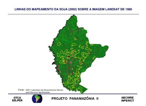
LINHAS DO MAPEAMENTO DA SOJA (2002) SOBRE A IMAGEM LANDSAT DE 1980Fonte : DSR / Laboratório de Sensoriamento Remotopara Recursos Agroflorestais