
Create successful ePaper yourself
Turn your PDF publications into a flip-book with our unique Google optimized e-Paper software.
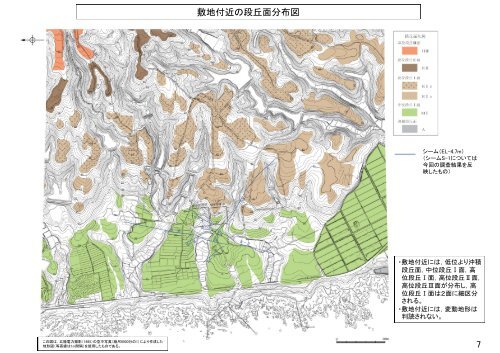
この図は,北陸電力撮影(1985)の空中写真(縮尺8000分の1)により作成した<br />
地形図(等高線は1m間隔)を使用したものである。<br />
敷地付近の段丘面分布図<br />
シーム(EL-4.7m)<br />
(シームS-1については<br />
今回の調査結果を反<br />
映したもの)<br />
・敷地付近には,低位より沖積<br />
段丘面,中位段丘Ⅰ面,高<br />
位段丘Ⅰ面,高位段丘Ⅱ面,<br />
高位段丘Ⅲ面が分布し,高<br />
位段丘Ⅰ面は2面に細区分<br />
される。<br />
・敷地付近には,変動地形は<br />
判読されない。<br />
7