
You also want an ePaper? Increase the reach of your titles
YUMPU automatically turns print PDFs into web optimized ePapers that Google loves.
430 430<br />
440 440<br />
450 450<br />
460 460<br />
470 470<br />
480 480<br />
490 490<br />
500 500<br />
510 510<br />
520 520<br />
530 530<br />
540 540<br />
3970 3970<br />
3960 3960<br />
3950 3950<br />
3940 3940<br />
3930 3930<br />
3920 3920<br />
3910 3910<br />
3900 3900<br />
3890 3890<br />
3880 3880<br />
3870 3870<br />
3860 3860<br />
3850 3850<br />
3840 3840<br />
3830 3830<br />
3820 3820<br />
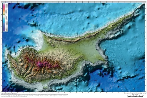
PLATE X: Topography and Bathymetry of the Island of Cyprus.<br />
This image is a composite of the 25 m DTM of Cyprus, together with the 181,748 soundings from the UKHD/UKHO hydrographic surveys interpolated to 25 m, plus every 20 th center beam sounding from NES Strakhov Cruises 5 and 10, and depth soundings digitized from the navigational charts of the Head Department<br />
of Navigation and Oceanography of the Russian Federation. Black dots show the locations of the depth soundings in these last two datasets. The deeper bathymetry was interpolated to a 100 m grid, using multiquadric surfaces, and overlain by the land topography and nearshore bathymetry reduced to 50 m. These<br />
datasets are described in Volume II, Chapter 15, p. 135-148. The resulting grid file, produced by Global Mapper® v. 6.09 in Universal Transverse Mercator (UTM) projection in Zone 36, was then plotted out as hypsometrically colored shaded relief by Surfer® 8. The graticule is in kilometers. This compilation shows<br />
some similarities and a number of differences with Figure 15.8 (Volume II, page 145) where the land and nearshore bathymetry are overlaid on the 50 m contours of the 1:625,000 scale Mercator chart of the Eastern Mediterranean (Hall, 1994). A few of the isolated peaks are probably from unreliable spot soundings.<br />
The need for seamless multibeam coverage is evidenced by the hints of structure in the widely dispersed sounding coverage.<br />
550 550<br />
560 560<br />
570 570<br />
580 580<br />
590 590<br />
600 600<br />
610 610<br />
620 620<br />
630 630<br />
640 640<br />
Universal Transverse Mercator Projection (UTM - Zone 36)<br />
Scale 1:250,000<br />
0 5 10 15 20 25 Km<br />
650 650<br />
660 660