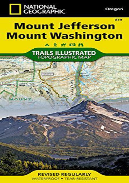
Mount Jefferson, Mount Washington (National Geographic Trails Illustrated Map)
Mount Jefferson, Mount Washington (National Geographic Trails Illustrated Map)
Mount Jefferson, Mount Washington (National Geographic Trails Illustrated Map)

You also want an ePaper? Increase the reach of your titles
YUMPU automatically turns print PDFs into web optimized ePapers that Google loves.
<strong>Mount</strong> <strong>Jefferson</strong>, <strong>Mount</strong> <strong>Washington</strong> (<strong>National</strong> <strong>Geographic</strong> <strong>Trails</strong> <strong>Illustrated</strong> <strong>Map</strong>) (<strong>National</strong> <strong>Geographic</strong> <strong>Map</strong>s - <strong>Trails</strong> <strong>Illustrated</strong>) • Waterproof • Tear-Resistant • Topographic <strong>Map</strong>The <strong>Mount</strong> <strong>Jefferson</strong> and <strong>Mount</strong> <strong>Washington</strong> Wilderness Areas are characterized by picturesque mountains, glaciers, alpine meadows, pine and fir forests, and over 175 lakes. <strong>National</strong> <strong>Geographic</strong>’s <strong>Trails</strong> <strong>Illustrated</strong> map of <strong>Mount</strong> <strong>Jefferson</strong> and <strong>Mount</strong> <strong>Washington</strong> combines unmatched detail with helpful information to offer an invaluable tool for making the most of your visit to the High Cascades. Expertly researched and created in partnership with local land management agencies, this map features key points of interest including Menagerie Wilderness; Detroit, Suttle, Clear, Marion, and Blue River lakes; McKenzie and Metolius rivers; and Santiam Pass Summer OHV Area. With hundreds of miles of mapped trails including portions of the Pacific Crest <strong>National</strong> Scenic Trail, Metolius-Windigo Trail, Lava River <strong>National</strong> Recreation Trail, this map can guide you off the beaten path and back again. Trail use is easy to identify, whether you’re hiking, biking, horseback riding, or OHVing. The McKenzie Pass–Santiam Pass and West Cascades scenic byways are noted for those wishing to take in the scenery by car. Many recreation features are noted as well, including campgrounds, horse camps, boat<br />
ramps, water ski and swimming areas, whitewater access, ski areas, sno-parks, interpretive sites, and points of interest. The map base includes contour lines and elevations for summits and passes.Every <strong>Trails</strong> <strong>Illustrated</strong> map is printed on "Backcountry Tough" waterproof, tear-resistant paper. A full UTM grid is printed on the map to aid with GPS navigation.Other features found on this map include: Black Butte, Cougar Reservoir, Deschutes <strong>National</strong> Forest, Detroit Lake, Green Ridge, Middle Santiam Wilderness, <strong>Mount</strong> <strong>Jefferson</strong>, <strong>Mount</strong> <strong>Jefferson</strong> Wilderness, <strong>Mount</strong> <strong>Washington</strong> Wilderness, Three Sisters Wilderness, Willamette <strong>National</strong> Forest.<strong>Map</strong> Scale = 1:75,000Sheet Size = 25.5" x 37.75"Folded Size = 4.25" x 9.25"<br />
<strong>Mount</strong> <strong>Jefferson</strong>, <strong>Mount</strong><br />
<strong>Washington</strong> (<strong>National</strong> <strong>Geographic</strong><br />
<strong>Trails</strong> <strong>Illustrated</strong> <strong>Map</strong>)


![Mount Rogers High Country [Grayson Highlands State Park] (National Geographic Trails Illustrated Map)](https://img.yumpu.com/59273457/1/184x260/mount-rogers-high-country-grayson-highlands-state-park-national-geographic-trails-illustrated-map.jpg?quality=85)